Showing posts with label Yarrowee River. Show all posts

20 April, 2016

Making tracks: decisions! Decisions!

Over the past six months and 21 blog posts, I've followed in the tracks of the gold diggers making their way from Geelong to Ballarat, looking at how they travelled, where they travelled, who they might have met along the way and what conditions they faced. The aim was to decide which - if any - of the various tracks was the "main" route to the goldfields - a claim made of each of these tracks at one time or another.
Google Earth image showing the likely routes via Shelford (red),
the Geelong-Buninyong Track (green) and Steiglitz (blue)
Teesdale it is claimed at a local park lay on the "main gold route". The Eclipse Inn north of Steiglitz was situated on the "best line of road" to the goldfields, boasted a real estate agent in 1853. A report by the Victorian Heritage Database states that "later the Warrenheip Road to Ballarat became the main gold fields route from Geelong", whilst in 1943 a local resident of the town of Meredith recounted that "when gold was first discovered at nearby Buninyong, Ballarat, Steiglitz and Bendigo, most of the traffic to those places started from Geelong and came through Meredith by bullock teams along bush tracks."
Even Skene St in the Geelong suburb of Newtown was claimed as part of "the main route to the Ballarat goldfields" - presumably a reflection of the flow of traffic west towards Fyansford and across the Moorabool River to the Geelong-Buninyong Track near the future site of Gheringhap.
The one thing which does seem clear is that each claim had its own angle: the best road, the main route, the most traffic, a particular point in time. What is clear however, is that over the years, huge amounts of traffic flowed along all routes to the goldfields of Ballarat. But were all the routes equivalent?
Store drays camped on road to Ballarat, TS Gill, 1855, Image held by the
National Library of Australia
Well, the distance of each was not the same. The journey from Geelong to Ballarat via the Geelong-Buninyong Track and the Plank Rd was around 50 miles (80km). From Geelong via Steiglitz and Warrenheip to Ballarat was about 59 miles (95km) whilst the track via the Leigh Rd to Shelford and then to Buninyong and along the Plank Rd was also around 59 miles. If travelling via Magpie Gully instead of the Plank Rd, then an extra mile or more could be added to the journey.
A difference of 9 miles or 15km is not so much on modern roads with fast cars, but to a digger walking the distance, this could amount to almost half a day's extra walking. If however, a dray were to become mired in Scott's Swamp, not only hours, but days could be lost, not to mention the potential for broken wheels and axles, the loss of an expensive horse or bullock or even the significant physical exertion required to unload and reload an entire dray full of supplies in order to lighten the load and escape the bog. As a result, whilst the shortest route may appeal to those on foot, road conditions may have been more important than distance to those travelling by vehicle.
To complicate the issue further, there were any number of alternate routes and tracks connecting each of the three roads running north-south. From the Steiglitz road it was possible to cross the Moorabool River and reach the Geelong-Buninyong Track via the Melbourne-Buninyong Rd intersecting at Green Tent, Sharp's Crossing which intersected at the same point, the Steiglitz-Meredith Rd and at least one other unnamed crossing to name a few.
From the west, it was possible to cross the Leigh River at 'Narmbool' and possibly also at an informal crossing near Bamganie. Today, a number of small fords cross the Leigh on private property, presumably it was no different in the 1850s. In a time when a bad track or tricky creek-crossing saw travellers take to the bush, forging their own path, it is not surprising that informal tracks and crossings proliferated.
Google Earth image showing the interconnecting tracks between Geelong and Ballarat. Red
lines show tracks marked on survey maps, blue lines show approximate routes described, yellow
lines show likely connections along and between routes using modern roads, green lines
show estimated routes based on surveyor's field books. Early inns along the routes are also shown.
Click to enlarge
Another important factor was date. When the gold rush first broke out in August, 1851 everyone wanted to be at Hiscock's Gully. Two weeks later, after the discovery of Golden Point, they were also flooding to Ballarat along the Geelong to Buninyong Track. The surface alluvial deposits however, were quickly worked out and within a short time, deep lead mining became common. As the miners followed these leads, mining activities spread out across the Sebastopol Plateau following the course of an ancient river underlying the Leigh. It makes sense that anyone travelling to these mines during the 1860s would consider travelling via Shelford.
At Steiglitz, the discovery of quartz reefs in 1855,  drew traffic from Geelong and also from Ballarat, presumably making the route from Geelong to Ballarat via Steiglitz and Warrenheip more appealing at that time. This road also provided access to other nearby goldfields such as Mt Egerton, Dolly's Creek and Gordon to name a handful.
Despite all of this however, it is worth remembering that coaches - including Cobb & Co.'s famous Leviathan Coach capable of carrying 89 passengers - continued to run directly between Geelong and Ballarat along what soon became the Geelong-Buninyong Rd. After the discoveries at Steiglitz, extra services ran via Hope's Bridge over Sutherland's Creek to the town, however coaches from Steiglitz for Ballarat still travelled via Meredith, Buninyong and Magpie Gully, rather than the Eclipse Inn and Warrenheip. A comparison of distance shows the coach route to be only a mile or so shorter than travelling via Warrenheip. I cannot see any mention of a coach service via Mt Mercer throughout the gold rush period, however the Portland Bay service from Geelong did pass through Shelford, Cressy and Fiery Creek further to the west.
Cobb & Co.'s Leviathan Coach, c1862. Image held by the Victorian State Library
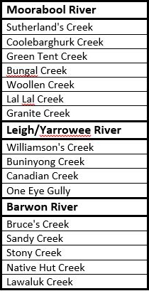
Regardless of which route the diggers chose, one thing was certain: at some point they would have to cross, walk alongside or take water from the the tributaries of the Barwon River. Whichever route they chose would require not just one, but numerous creek and river crossings. Whether at Batesford, Fyansford or east of Buninyong, the Moorabool River had to be crossed. Travelling via Shelford also meant crossing the Leigh/Yarrowee River at least twice, if not three times, not to mention the many creeks and gullies along the way. Below is a list of the main creeks along the three routes, grouped according to the river into which they flow.
In the early days before bridges were built, fording creeks and rivers was inevitable and bad weather could have a significant impact, not only on the road surface, but also on the ease with which a creek or river could be crossed - if it could be crossed at all. Newspaper reports of flooding often also came with reports of drownings, both of animals and humans as attempts were made to cross dangerously swollen creeks and rivers. Another reason for diggers to consider carefully which route to take.
There is one other factor which could also influence the decision and which could significantly alter the flow of traffic along a particular road: maps.
And some of those maps will be the topic of my next post.

10 February, 2016

Making tracks: beside Yuille's Swamp

When gold was first discovered at Hiscock's Gully in August, 1851, the track from Geelong led to Buninyong. There was no town at Ballarat. At the time, the only European settlement in the area that would become Ballarat, was a squatting run. It was occupied in 1838 by 19 year old Scottish settler, William Cross Yuille and his cousin Archibald Buchanan Yuille who had left their earlier run on the Barwon River at Murgheboluc after coming into conflict with the local Wathaurong tribe.
In March, 1838 therefore, they selected 10,000 acres north west of Mt Buninyong on the shores of a swamp. This run which in today's terms included the inner suburbs of Ballarat and extended south as far as Sebastopol was known as "Ballaarat". When William Cross Yuille first arrived (shortly before his cousin), he camped on the edge of what was then known as Black Swamp. Soon it became known as Yuille's Swamp and today is recognised as Lake Wendouree.
A memorial erected in 1938 on the banks of Lake Wendouree
(near the end of Pleasant St) commemorating the arrival of
William C Yuille, the first European to live in the district
Whilst William remained only a short time in the district before heading to New Zealand in 1840, his cousin retained the license for the run until 1857. One of his nearest neighbours was Henry Anderson who settled at what became known as Winter's Flat at about the same time. He named his 26,000 acre run "Waverley Park" and built a homestead near the junction of Woolshed Creek and the Yarrowee River. He did not remain long in the district however and in 1842, sold out to John 'Jock' Winter who renamed the run "Bonshaw".
Photo of William Cross Yuille, taken in 1894. Image
held by the State Library of Victoria
The homestead built by Anderson however, was taken over by Archibald Yuille who also began constructing a more permanent house on the property. With the coming of the gold rush however, Yuille abandoned his plans for the run and by 1852, had left the district.
The site of the homestead was described some years later in The History of Ballarat from the First Pastoral Settlement to the Present Time (WB Withers, 1887, 2nd Edition)
Down the valley of the Leigh where the Sebastopol streets and fences run over the eastern escarpment of the table land, may still be seen the sandstone foundations of a station begun by the Messrs. Yuille, whom the coming of the first hosts of gold-hunters scared away from a place no longer fit, in their opinion, for pastoral occupation. Those unfinished walls are in a paddock overlooking a little carse of some four or five acres by the creek side, owned by an Italian farmer, and close to the junction of the Woolshed Creek with the main stream in the valley.
In today's terms, the homestead site would have been situated at the end of Bala Street in Sebastopol and the "little carse" later owned by Mr J Grenno forms part of the wetlands next to the river, through which the Yarrowee Trail now passes.
Sketch of the homestead on Woolshed Creek, built by Henry Anderson and later'
occupied by Archibald Yuille. Image held by the National Library of Australia
When the Yuilles first arrived however, there was no Sebastopol and no Ballarat township.The tracks made by their bullocks and those of the other squatters spreading out across the region became the road from Buninyong. The branch of the track which led to the Pyrenees region near Avoca, passed only a stone's throw from the Yuille's homestead. In time, this section of the track became Albert Street; now one of the oldest roads in inland Victoria.
After passing the Yuille's homestead on Woolshed Creek, the track followed the ridge line above the Yarrowee River before curving away to the north - somewhere near the intersection of Grant and Moyle Streets - taking a path to the east of Lake Wendouree towards the Pyrenees.
At that time, Yuille's Swamp really was a swamp, teeming with wildlife and a summer camping place for the local Wathaurong people. After the town of Ballarat was established however, earthworks were built and modifications were made in order to provide a water supply for the town, resulting in the lake we see today.
The view across Yuille's Swamp (now Lake Wendouree) from the site of W.C.
Yuille's first camp
Whilst the very first gold diggers to spread out from Hiscock's Gully to search the creeks and waterways of the area may have forged their own paths through the bush, those who came after them, followed the bullock tracks and stock routes used by the Yuilles and other squatters in the area.
The track to the Pyrenees district also led to the town of Clunes, where gold had been discovered a few weeks before Hiscock's discovery at Buninyong, so some of those disappointed at Hiscock's Gully, decided to try their luck at Clunes instead.
Others, upon hearing the news, rushed to investigate the new find by Dunlop and Regan only a few miles away on the Yuille's Ballarat run.  Taking to the track once again, they made the much shorter journey to Poverty Point, taking with them their pans, cradles, tents and what supplies they had, hoping this time to strike it rich.

23 September, 2015

Branching out - silting up

On 1st July, 1851 two things occurred which changed the face of the Barwon catchment forever. On that date, Victoria was declared a separate colony from New South Wales and gold was discovered at Clunes on Creswick Creek, a tributary of the Lodden River. Five days later, James Esmond arrived in Geelong with samples of the gold found by himself and his two companions. Two days after that, the Geelong Advertiser published the news. By the end of the month, the Victorian gold rush had begun.
The first gold discovery in the Barwon catchment occurred only weeks after the initial discovery at Clunes on 8th August.
Information board near the site of Hiscock's first gold
discovery, situated roughly opposite the Buninyong Cemetery.
On that day, Thomas Hiscock - a blacksmith who had migrated from England ten years before - discovered gold in a gully which now bears his name, in the Buninyong Ranges west of the town.
Like the many creeks and gullies in the area, Hiscock's Gully ultimately drains into the Yarrowee/Leigh River and empties into the Barwon River at Inverleigh.

A memorial erected some distance to the east of the above
sign and which commemorates Hiscock's discovery
Ten days later, gold was also discovered at Poverty Point, Ballarat, on the banks of Canadian Creek only a few hundred metres from its confluence with the Yarrowee River. Within a matter of months around 20,000 hopeful prospectors had flocked to the region to work the easily accessible alluvial deposits.
Sign describing the first Ballarat gold discovery and
subsequent events
This initial rush was followed in subsequent years by the arrival of the big mining companies with the heavy equipment used to mine the deeper quartz reefs of the district. This saw excavation along the Leigh/Yarrowee, extend downstream past Garibaldi to the Leigh Grand Junction and beyond. 
The impact on the river and the creeks and gullies which flow into it was profound. The initial alluvial mining saw a significant reduction in the native vegetation as trees were cleared to make way for mining exploits or harvested for use in construction of the necessary infrastructure. Across the upper part of the catchment, the miners dug into the banks of the waterways, diverted water flows and turned over the soils of the creeks and river flats of the catchment. As they worked, large piles of discarded timber from felled trees washed downstream, causing logjams and impeding water flow. At the same time tonnes of rock and soil were displaced, leaving huge piles of tailings or mullock heaps littering the landscape.
Consequently, as early as the 1860s, the finer sediments from these deposits began to wash into the waterways and make their way into the Yarrowee River before working their way downstream towards the Barwon. On 29th October, 1869 a correspondent to the Geelong Advertiser wrote that:
For a number of years residents on and near the banks of the [Leigh River], and also those on that part of the Barwon below Inverleigh, have quietly looked upon their lands becoming impoverished by the settlement of silt upon them. The effect of the late flood, however, places the matter in a very serious light, and calls for immediate action. Beautiful flats of rich black soil have been converted into beds of clay, and that of the very worst description. Farms that a few years ago would have been suitable for the most exhaustive crops, are now rendered by the accumulation of sludge unfit for the production of grass....The bed of the river is rapidly filling up, consequently such floods must be more frequent and more disastrous.
By 1906 a Sludge Abatement Board had been established to monitor the water quality of rivers and was being called upon to address the complaints of the shires downstream on the Leigh which continued to bear the brunt of the problem. The sludge could be anywhere from about 45 - 180cm thick, with the largest deposits occurring on river bends. As the sediment flowed downstream and filled in pools and hollows, the rate of flow and the volume of the channel would also have decreased.
This image of the Yarrowee Dredging Co mine, 1889 (possibly the Yarrowee
Creek No 1 Gold Dredging Co) shows the degree of deforestation and erosion
caused by mining activity along the river. Image held by the
State Library of Victoria
In recent years, reports commissioned by the Corangamite Catchment Management Authority have confirmed what was evident 150 years ago. Modern understanding of the way vegetation affects hydrology, has also revealed the role deforestation must have played in increasing the quantity and rate at which runoff water entered the river. Today, the silts which were deposited after the beginning of the gold rush are referred to as Post Mining Alluvium and form the surface layer of soil in the area around Shelford and Inverleigh.
Meanwhile over on the Moorabool River, gold was also the order of the day, although the discovery and subsequent mining boom was a little later in coming. Gold was first discovered on the Durdidwarrah property of Augustus von Stieglitz in 1851, however the quantities were not considered workable. Some activity ensued in 1853 when Andrew Love and George Morton discovered alluvial gold on Sutherland's Creek, however, it was not until 1855 when William Hooley and Joseph Davis discovered a gold reef on Sutherland's Creek near Steiglitz that the rush really began.
From 1855 onwards, alluvial gold was extracted at various creeks and gullies along the Moorabool River including Sutherland's Creek, Dolly's Creek, Tea Tree Creek, Mt Doran, the Stony Rises (Elaine) and from the banks of the Moorabool itself at Morrison's however it was not until the 1860s that the large companies moved in and reef mining began in earnest.
The remaining brick footings of the United Albion Mine near Steiglitz
It seems however that the threat of a sludge deluge such as that seen on the Leigh, was not as much of an issue for the Moorabool River. Perhaps this is a reflection of the relatively greater proportion of reef mining in comparison to alluvial activity on the Moorabool.
It is interesting to note that a 2006 report commissioned for the Corangamite Catchment Management Authority showed that despite the greater water flow of the Barwon and the historic issues of increased sedimentation due to mining activities along the Leigh, it is the Moorabool which makes the greatest contribution to sediment deposited downstream at Lake Connewarre. There is no indication that this is related to earlier mining activities, instead it is postulated that the greater overall change in gradient along its length (by comparison with the Barwon and the Leigh) may account for the difference.

02 September, 2015

Branching out - The Garibaldi Bridge

My previous post illustrated the changes in materials used over the last century and beyond to patch and repair existing bridges in order to extend their useful lifespan. This has resulted in many bridges in the Barwon catchment region becoming hybrids, neither timber nor steel, concrete nor stone, but in many cases, a combination of different building materials.
Another great example of this type of evolving bridge, is the old bridge (now replaced by a modern concrete structure) across the Yarrowee/Leigh River on the Buninyong-Mt Mercer Road at Garibaldi. According to the media of the day, the foundation stone for the original bridge was laid in November, 1866 amidst much fanfare by the Buninyong Shire President Mr WH Bacchus. The region he declared, was in urgent need of a bridge as three people had lost their lives in recent years, attempting to ford the river during floods. The president was presented with an inscribed, silver trowel which he used to lay the stone along with a time capsule containing issues of several local newspapers and "a document in reference to the constitution of the shire, and the various coins of the realm". Once the president had declared the stone "well and truly laid", the company retired to the nearby Garibaldi Hotel where luncheon was laid on for 50 invited guests, with a keg of beer also provided for members of the local community. November, 2016 will mark the 150th anniversary of this event.
The old Garibaldi Bridge today
Less than a year later in April, 1867, under the name of the Durham Bridge, the new structure was officially opened. Disappointment was expressed at the event (which also included speeches, toasts and another luncheon) at the small number present to mark the occasion.
I can find no image of the bridge in its original (or any) form which shows its exact construction, but at the time of its opening, the bridge was described as measuring 100 ft in length and including three spans of 33 ft each, secured at each end by bluestone ashlar abutments and in the centre by two stone buttresses (pillars). The wooden deck was supported within each span by spandrels atop rows of 7 corbels resting on the stonework of each abutment or buttress and - it was proudly claimed - stood 6 ft clear of the highest recorded flood mark. The total cost of construction was £2,699.
Looking upriver from the bridge, August, 2015
The first real test of the new structure came barely two years later in 1869 when the Yarrowee flooded, leaving large parts of Ballarat under water. It is a testament to the strength of stone bridges, that there is no further mention of the bridge throughout the remainder of the 19th century and this despite regular reports of substantial flooding over the years. In fact it seems that substantial maintenance was not required until December, 1914 when then shire engineer CCP Wilson reported that the bridge superstructure had been removed and the masonry prepared for replacement of the deck with a concrete structure. Interestingly, although they may not have foreseen the development of concrete in the construction of bridges, the original stonework was built in 1867 with a view to the future replacement of the timber structures with masonry.
These repairs it would seem stood for a further 19 years until December, 1933 when the Yarrowee/Leigh River experienced substantial flooding - the largest it was claimed in 50 years. Over the course of three days from 30th November to the 2nd December, catchments across the region were deluged, causing the bridge to collapse, washing away two of the three spans.
One abutment and parts of the deck of the Garibaldi Bridge washed away
during the 1933 floods. Image held by the Federation University Australia's
EJ Barker Library
Remains of the Garibaldi Bridge during the 1933 floods. Image held by the
Federation University Historical Collection
So great was the destruction across parts of the state that it was beyond the capacity of many municipalities to pay for the damage. This was certainly the case for Buninyong Shire which along with other shires sent a delegation to wait upon the minister to plead their case for funds. On this occasion, the government declined to offer flood relief for the affected shires. Buninyong looked at taking out a loan or applying for grants to cover their costs.
The Garibaldi Bridge, 2015 looking to the south east
Early estimates indicated that it would cost in the vicinity of £1,750 to repair the damage to the Garibaldi Bridge, however in March the following year, engineer Wilson stated that the job could be done for £1,000 - possibly less. The following month, approval was granted to purchase the necessary materials to complete the reconstruction.
It is perhaps this sequence of events and the need to economise which lead to the evolution of the bridge as we see it today. The deck appears to me to be narrower than the original structure of which, only one stone abutment, one buttress and the stone parapets remain. The other buttress and the southern abutment have been reconstructed in concrete as has the deck which is supported across two of its spans by concrete corbels. The span at the northern end of the bridge however, is not the same as the other two and seems to have been repaired in a different style and perhaps at a different time - although I can find no record of this.
The central and northern spans of the bridge, looking south west
The handrails which top the deck are typical of the water pipe and cyclone wire constructions used by CCP Wilson on other projects and the overall structure is not dissimilar to the Blue Bridge on the Yendon-Egerton Road, also repaired by Wilson. These repairs whilst perhaps looking a little unorthodox, have survived the test of time. The bridge carried traffic until as recently as 2007 when the annual report for the Golden Plains Shire for 2006/2007 indicated that a new bridge had been completed (slightly downstream) at a cost of $853,000.
The new Garibaldi Bridge
Today, the original bridge stands disused and largely unnoticed beside the new Garibaldi Bridge.

11 September, 2014

Branching out - a walk along the Leigh

Over the past fortnight, I have been fortunate to have the opportunity to walk along a section of the Yarrowee/Leigh River above the Junction Bridge near Mt Mercer, accompanied by the land owner. I am intending to look at the Junction Bridge in a separate post so for now I will focus on the section of river which we walked along.
The first walk (and the topic of this post) saw us start near the bridge and walk along the western bank for about 2.5km.
The land along this part of the river, despite having been altered by white settlement, retains a wide variety of natural diversity which was eagerly pointed out to us. In addition to the flora and fauna, there are also a number of manmade changes to the surrounding landscape.

Mullock heap
One notable human remnant is a large mullock heap, the tailings from a mining venture along the banks of the river. Scattered through the area are many shallow diggings which mark places where miners have tested the ground in their search for gold.

A natural beach on the opposite bank
The river itself, is narrow and in many places quite shallow, however this can vary depending on the season with river levels rising dramatically and quickly during times of flood. One feature which was pointed out to us was a distinctive ledge which marked the edge of a basalt flow, a visible reminder of the volcanic plains through which the Barwon and its tributaries flow towards the sea.
Basalt flow running down to the river
The Leigh carves a path through the basalt
Reflections
Further upstream is a striking stand of Candlebarks (aka Eucalyptus rubida) with their pale trunks and piles of bark shed by the tree which cluster at the bottom, giving the impression (according to Wikipedia) of a candle stub. It was pointed out to us how clear of undergrowth the ground beneath the Candlebarks was, in contrast to other parts of the surrounding bushland which were carpeted by grasses and bracken.
The Candlebarks


Although much of the native flora is evident, also to be seen are a number of pervasive weeds such as blackberry, gorse, periwinkle and wattle trees. Whilst ongoing attempts have been made over the years to clear the land of these pervasive pests, nearby crown land has not been likewise maintained, meaning that reinfestation is a continuous battle.
Looking towards the conjunction of Upper Williamsons Creek and the
Leigh (notice the gorse bushes with their yellow flowers)
The above picture was taken roughly near the confluence of Williamsons Creek and the river which above the confluence is known as the Yarrowee River and below it as the Leigh. This was roughly then end point of our first walk.
Our second walk will be the subject of a future post.


26 June, 2014

A watershed moment

As this blog has progressed over the last three years, its scope has grown to include the two major tributaries of the Barwon - the Leigh/Yarrowee and Moorabool Rivers - as well as the smaller creeks which also drain into each of the three rivers. Then, a while back I was asked what area was included in the watershed of the Barwon.
Good question! I knew in general terms that it would include the three rivers and any creeks and streams which flowed into them, but just how far did that extend? So I thought I'd have a bit of a look an see what maps and diagrams were available that would provide a visual image.
On the Australian National Library's website I soon found several historical maps which outlined the area including the following map published in the 1950s:

Map of the Barwon watershed. Image produced by the Victorian State
Rivers and Water Supply Commission, 1954 and held by the State Library
of Victoria (Click to enlarge)
As expected, the extremities of the watershed to the headwaters of the three rivers and the Barwon river mouth at Barwon Heads. The most southerly extent of the catchment lies to the south of the township of Forrest in the Otway Ranges, with the peaks of that mountain range providing a dividing line between the Upper Barwon and the Victorian coastline. In the north, the watershed extends from Ballarat where the Yarrowee River rises in the city, to a point north of Ballan in the Wombat Sate Forest where the east and west branches of the Moorabool River begin their journey to the sea.
For administrative purposes, the Barwon catchment area falls within the boundaries Corangamite Catchment Management Authority (CCMA). The Corangamite Catchment is responsible for some 13,340 square kilometres from Ballarat to Geelong and the Bellarine Peninsula and along the coast to the town of Peterborough which lies about 50km east of Warrnambool. It is one of ten such authorities which cover Victoria.
Map of the Victorian catchment management authorities taken from the
Department of Environment and Primary Industries website
For provision of services such as drinking water and sewerage, the Barwon and its tributaries - as far as I can tell - fall under the jurisdiction of two water authorities. The majority of catchment area is contained within the area serviced by Barwon Water which includes an area of about 8,100 square kilometres from Apollo Bay in the west to Meredith and Cressy in the north and to Little River and the Bellarine Peninsula in the north and east. This map on the Barwon Water website shows the extent of the area of supply. Those parts which do not fall under the auspices of Barwon Water are the upper reaches of the Moorabool and Yarrowee/Leigh Rivers which lie in the area controlled by Central Highlands Water servicing an area of 9,275 square kilometres.
But this still doesn't exactly answer the question: what is the combined catchment area of the three rivers - Barwon, Moorabool and Leigh/Yarrowee?
Another 1950s depiction of the Barwon watershed, titled Catchments
of Barwon River and inland Basins, created by the Victorian State Rivers
and Water Supply Commission and held by the Victorian State Library
(click to enlarge)
According to Wikipedia, the watershed of the Barwon and its tributaries makes up about 8,590 square kilometres, however I have not been able to independently verify this and suspect it may refer to the full extent of Barwon Water which includes catchment regions which are not part of the Barwon system. According to various other websites, the Moorabool River accounts for 2,300 square kilometres, the Yarrowee/Leigh River for around 890 square kilometres, however it seems very hard to find a clear answer for the Barwon itself.
The City of Great Geelong website indicates that the Barwon's catchment extends to 3,700 square kilometres. Given the area covered I believe this refers only to water flowing directly into the Barwon however the wording is ambiguous. Assuming that my interpretation is correct, then the combined catchment area of the three rivers is in the region of 7,790 square kilometres or more than three quarters of a million hectares - but less than the 8,590 square kilometres suggested by Wikipedia.
So, in short, I'm not precisely sure, however if anyone can provide a figure, I would be pleased to add it to this post.
NOTE: subsequent to publishing this post, the CCMA inform me that "Corangamite CMA's GIS (Geographic Information System) figure is 495,480 ha for the entire basin including Upper Barwon, Barwon, Murdeduke, Leigh, Moorabool" which converts to the much smaller figure of 4,955 square kilometres for the Barwon watershed plus the Murdeduke Basin.

03 July, 2012

Branching out - Big Storm on the New Gold Mountain

This week-end saw us spend the night in Ballarat - a place I have been to on and off my entire life. In keeping with the accepted stereotype, it was cold and wet which somewhat limited photographic opportunities.
Despite this, I did still manage to snap a few shots of the Yarrowee River as it runs through town on its way down to join the Barwon at Inverleigh (by which time it has become the Leigh). At this point, I know very little about the Yarrowee and what I've seen so far isn't impressive. This poor river as it runs through Ballarat is little more than an open drain.
Grant Street bridge over the bluestone-lined Yarrowee River
A quick history lesson courtesy of my other good friend Mr Wiki, informs me that the Yarrowee was prone to flooding, causing problems for the initial inhabitants of the township of Ballarat. This was remedied in 1877 when a dam was built out of town at Gong Gong near the river's headwaters which also supplied water for the town.
The Yarrowee River looking upstream from Grant Street towards town and
the confluence with Canadian Creek
During the gold rush era the river through Ballarat was used not only a supply of drinking water but also provided water for the mines as well as itself being mined for alluvial gold. Problems at this time with erosion and flooding saw much of the watercourse through town lined with bluestone. These stone-lined channels can still be seen across the city, not only along the Yarrowee but also along the several creeks which feed into the river as it passes through the suburbs.
The same view as above on a nicer day
During the early 20th century, the river became very polluted as industry grew and then in the 1960s, the river through the CBD was rerouted and completely sealed over so that it now runs through an underground channel along Grenville St before re-emerging downstream near Dana St.
View from Grant St looking down river
In more recent times there has been a push to improve river health, including the construction of wetlands which naturally filter the stormwater running into the river. This is not a new idea. The largest and best known wetland associated with the Yarrowee through Ballarat is of course Lake Wendouree which was constructed during the gold rush days from the area known as Yuille's Swamp after Archibald Buchanan Yuille, an early squatter who built his home on the edge of the swamp.
"Lake" Wendouree in May, 2007 during the drought with Mt Buninyong
in the distance
At this point it might also be of interest to provide definitions for a few names, most of which come from the local Wathaurong clan of Boro gundidj. The name Ballarat - originally Balla arat - is thought to have meant "resting place". Wendouree is a corruption of the Wathaurong word wendaaree meaning "go away". Legend has it that this was the response given by a local tribeswoman when asked by William Cross Yuille (brother of Archibald) what the name of the place was.
The origins of the name Yarrowee however are not so clear. It seems to be most commonly held that the name was given to the river by the Scottish settlers to the district who named it after Yarrow Water, a river in Scotland. However while we were in town we dropped in to the Gold Museum at Sovereign Hill. Here I found an alternative explanation. It was suggested that Yarrowee is in fact a Wathaurong word meaning "big storm".
Other names from the region reflect the influx of peoples of all nationalities to the goldfields. A tributary of the Yarrowee I mentioned earlier is Canadian Creek. Out of town and south west of Buninyong (a Wathaurong word meaning "man lying on his back with his knee raised" - yes, really!) is Scotchman's Lead.
One ethnic group who represented a quarter of those on the goldfields but who were intensely disliked by the other miners were the Chinese. Whilst their presence is not prominently reflected in today's place names, I do know that the Chinese referred to the Victorian gold diggings as "The New Gold Mountain" - the other being the diggings in California - and hence the title of this blog post.
As I said, no spectacular photography for this post, but hopefully I will soon rectify this with some photos of the more rural parts of the river.

13 March, 2012

Branching out - a look at the Leigh

For some time I have intended to spend a little more time investigating the Leigh River. In addition to the Moorabool River it is one of only two rivers which are tributaries of the Barwon.
The Leigh begins its journey in the suburbs of Ballarat where it rises as the Yarrowee River in Redan, flowing south through the foothills of the Great Dividing Range where it becomes known as the Leigh River at its confluence with Williamson Creek west of the township of Elaine. From here it flows past Bamganie, through Shelford to Inverleigh where it joins with the Barwon River outside of the township.
Previously I have walked the short section of the river between the township of Inverleigh and its confluence with the Barwon.
The confluence of the Barwon (right) and Leigh Rivers (left).
It is rural, pretty and popular with walkers and fishermen. There is a path running from the township to the junction of the two rivers and beyond that, a rough walking/driving track which extends to the Inverleigh-Winchelsea Road. To one side is the town and across the river on the opposite bank is farm land.
Leigh River downstream of Inverleigh
Today the weather was fine and we decided to investigate the Leigh upstream of the town, but first, a little history:
It has been suggested that the first European to visit the region was the escaped convict William Buckley after whom Buckley Falls on the Barwon is named, but this has not been proven.
The Leigh itself appears to have been named by the surveyor J.H. Wedge in 1835 after his Tasmanian property called "Leighlands". By the late 1830s the surrounding land, known as Weatherboard Station, was owned by the Derwent Company.
Our first stop on our walk was Lawson's Tree near the banks of the river. It was under this tree some time between 1836 and 1838 that William Lawson, a blacksmith from Weatherboard Station, erected his first home.
Lawson's Tree, Inverleigh
By 1842 he had built an establishment which he called - appropriately enough - the Horseshoe Inn, only a short distance away. The township which grew up here - Inverleigh - was known in those early days as Lawson's, although the man himself left the district in 1852.
Where the Hamilton Highway now crosses the Leigh was the site of a ford used by the early settlers traveling to and from the Western District and Geelong. The first bridge was built here by the Lawson family but was replaced in the 1870s by the shire council.
Footings of the old Inverleigh Bridge
Today the bridge is a modern concrete construction, but the footings of the earlier bridge can still be seen slightly upstream of the present structure.
From Lawson's Tree, we made our way to the much newer Federation Bridge built - yes - in 2001 to mark the centenary of Federation.
Federation Bridge over the Leigh River

It is a suspension bridge designed for pedestrian traffic and from here one can walk some distance upstream along a dirt path through areas of remnant vegetation, crossing dry creek beds and in our case, surrounded by fluttering butterflies.
Creek bed along the Leigh River
Efforts to encourage re-vegetation in the area are also under way, however there is also clear evidence of the early days of European settlement along some parts of the river where peppercorn trees jostle for space with gum trees and blackberries have taken over a small island in the middle of the stream.
Peppercorns and Eucalypts, Leigh River
Somewhat like the Moorabool, but in contrast to the Barwon, the channel through which the Leigh flows in this area is relatively deep with steep sides.
Channel carved by the Leigh River
Also like the Moorabool, the water level during floods can rise quite dramatically. The level of a previous flood event is clearly indicated by a hay bale wedged firmly in a tree, well above head height.
Hay bale stuck in a tree
We followed the path to its end and then returned the way we had come to the Federation Bridge where we took the opportunity to climb up to the lookout and view the surrounding countryside. From there, we followed the undulating (and in places slippery) gravel path along the river back to the Hamilton Highway where we crossed the bridge to complete our circuit and retired to the store for coffee and an ice-cream.