Showing posts with label Gold mining. Show all posts

22 May, 2016

Mapping the Barwon Catchment

Before the arrival of John Batman and his party on the shores of Port Phillip Bay in 1835, the indigenous tribes of the Barwon catchment walked the land, following traditional "songlines" which had evolved over thousands of years. The songs and stories of the many tribes, described the land and the physical pathways they used to cross the countryside, enabling them to navigate long distances, passing safely through unfamiliar territory. I discussed songlines in my previous post.
Europeans on the other hand, saw the land very differently to the indigenous population and used very different navigation techniques. The Europeans too used maps, however they drew their maps on paper, measured distance, calculated elevations and aligned everything according to compass bearings. And they way they travelled was vastly different too. Whilst many still walked, others rode horses and drove bullock drays and it wasn't long before the paths of the songlines became the bullock tracks of the squatters. They in turn were followed by the surveyors with their chains and newfangled theodolites who marked out the roads of the selectors and villagers.
The settlers were also quick to start applying their own mapping techniques to their new surroundings. The squatter's runs were plotted out and the bullock tracks which linked them with the towns which began to pop up, were marked as vague wavy lines.
Section of Surveyor Alexander Skene's 1845 map of the Geelong District
showing early tracks and the names of squatters and early landholders
across the catchment. Original image held by the State Library of Victoria
The more the number of settlers increased however, and the more they extended the boundaries of their settled districts, the more maps were created. Not only did these maps indicate direction and location, but there were also administrative maps, electoral maps, geological maps, maps which indicated individual land ownership (an unfamiliar concept to the indigenous peoples), weather maps and many other types of maps besides. Soon the entire colony had been layered with maps and amongst the earliest of these maps were survey maps.
In order to better administer the vast areas of the new colony, the land was formally divided for the purpose of administering the sale and distribution of land. From the late 1840s until the 1890s, the government progressively undertook a comprehensive survey of the  Colony of Victoria, reclaiming the squatters' leaseholds and breaking up the thousands of acres into village allotments and farm-sized blocks. To aid administration, county boundaries were established and within each county the land was subdivided into civil parishes.
Portion of the Victorian Counties Atlas, 1874, showing those counties which fall
within the Barwon Catchment. Image taken from the State Library of Victoria
Initially, the county boundaries were by necessity ill-defined and changed according to need. The following description from the Geelong Advertiser 17th July, 1841, claiming to give the first official description of Grant County's limits, shows both how they changed over time and - like the Wathaurong whose lands it covered - how the new settlers also used the natural landscape to define boundaries.
The Coast Line from the mouth of the Werriby(sic), Port Phillip, round to a point bearing south of the sources of the Barwon [Barwon Heads]. An imaginary line from that point to the sources of the Barwon [the Otways]. the Barwon from its sources to its junction with the Native Hut Creek. The Native Hut Creek from that junction to the Buninyong and Melbourne road(sic). The line of that road to the Werriby, and The Werriby River to its mouth.
By 1871, the 37 Victorian counties as we know them today were in place. Counties and their accompanying civil parishes were - and still are - used entirely for real estate purposes, enabling the physical description of a piece of land.
Section of 1881 Victorian civil parishes map. Original image held by the
State Library of Victoria
With European settlement came the English system of government. Having been declared a separate colony from New South Wales on 1st July, 1851, Victoria needed to put a government in place, however it was not quite the system we have today. The original Victorian parliament was unicameral - having only one house. Called the Legislative Council, it was composed of 16 electoral districts from which 30 members were chosen. Ten were nominated by the Lieutenant-Governor and 20 were elected from the eligible voting population. To be eligible to vote a person had to be a male British citizen over the age of 21 who paid more than £10 per annum in rent or held the freehold for property valued at more than £100. Once again the colony was mapped and divided. This time for electoral purposes. The Wikipedia map below shows the original electoral districts and I have indicated the general area of the Barwon catchment within the black box.
Electoral districts of the original Victorian Legislative Council, 1851.
Original image from Wikipedia
Within a handful of years however, electoral boundaries were being shuffled and in 1856 a second or lower house - the Legislative Assembly - was introduced, resulting in the system we have today.
State electoral districts for both the upper and lower houses of the Victorian parliament have continued to change in response to the growing population. Today there are 88 electoral districts, each corresponding to a seat in the Legislative Assembly. These are combined into eight districts from which five Legislative Council members are elected, giving a total of 40 members in the upper house.
Current boundaries of the state electoral districts (lower house) which
cover the Barwon catchment. Original image from Wikipedia
In 1901, the cartographic landscape of the Barwon catchment changed once again with the advent of Federation. The Colony of Victoria became the State of Victoria and was divided for the purpose of voting into federal electoral divisions. These were (and still are) different to the electoral districts of the state government. The electorates of Corangamite, Ballarat and Corio are all, at least in part, within the catchment.
Federal seats within the Barwon catchment. Original image from Wikipedia
Of course, beneath the federal and state levels of government is local government. In the 19th century, local government stemmed from the need to raise funds for roads and infrastructure, consequently a series of "road districts" were gazetted across the colony. Within a few years, the road districts were transformed into shires which along with cities and boroughs today make up the various municipal districts of the local government system. Not surprisingly, as with state and federal electorates as well as county and parish boundaries, the banks of the creeks and rivers of the Barwon catchment often formed the boundaries of these early shires too. Also in keeping with other levels of government, the number of municipal districts has changed over the years. For instance, in 1915, the Shire of Meredith was amalgamated with that of Bannockburn.
Country Roads Board map, 1961 showing parish boundaries. Original image held by the
State Library of Victoria
In 1994, sweeping changes saw the amalgamation of many smaller shires and city councils in to a lesser number of much larger shires and cities. Where before the catchment contained perhaps as many as many as 15 shires and cities, after the amalgamations, this number fell to around six.
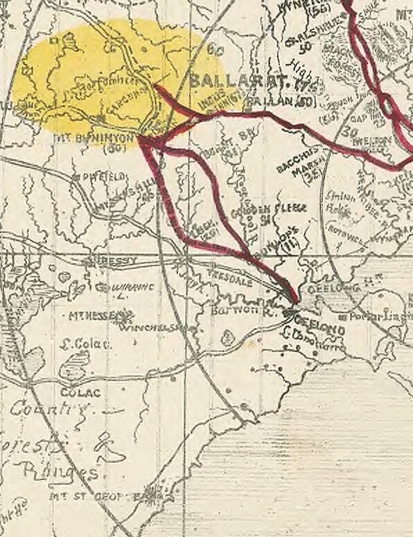
The outbreak of the Victorian gold rush in August, 1851 also saw a flurry of map making. Every digger wanted to know the best route to get to the diggings. As I have written before, there were claims, counter claims, insults and outright lies hurled back and forth between parties with vested interests in promoting their route to the diggings. Maps could not only be used to inform the general public (as below), but also to deceive as Geelong discovered when interests in Melbourne published a "false map".
The relevant section of a reasonably accurate "Digger's road guide to the gold mines of
Victoria and the country extending 210 miles around Melbourne", 1853. Image taken from
the National Library of Australia
 As well as the topography of the land and the roads and tracks which crossed it, the gold rush led to an intense interest in what lay under the surface of the soil. In 1852 Alfred Selwyn was appointed as Mineral Surveyor for the Geological Survey of Victoria and with one assistant and a tent-keeper, set about completing a comprehensive geological survey of the colony. Soil types were assessed, rock deposits dated and the potential presence of minerals noted. Over the years, the department expanded and exists today under the portfolio of the Department of Energy and Earth Resources in the Department of Economic Development, Jobs, Transport and Resources.
Adaption of the 1909 Geological Survey Map of Victoria. Image held by the
State Library of Victoria
Finally, another topic which has always been of particular interest to those living in the Barwon catchment. Rainfall. How much? How little? When? Where? Once again, the indigenous tribes had intimate knowledge of seasonal changes in climate and climate-dependent resources. The European settlers were equally as interested. They needed to know when to plant their crops and where to find water for their stock in different seasons.
Meteorological recording began in Melbourne as early as 1840 and regular, coordinated data collection began in 1854 with the establishment of the Victorian Meteorological Office. The first official report of rainfall data (I could locate) for Geelong appeared in the Victorian Government Gazette dated 21st August, 1857 for the April-June quarter of that year, although references were made elsewhere to earlier data.
Today, rainfall measurements are taken at various points across the Barwon catchment, including Weeaproinah in the Otways, near the headwaters of the Barwon River which has the highest average rainfall in the state. By contrast, the lowlands along the lower reaches of the Barwon, Leigh and Moorabool Rivers lie in the rain shadow cast by the Otway Ranges and receive a significantly lower annual rainfall.
Overview of long term rainfall averages for the Barwon catchment. Graph taken
from the Australian Bureau of Meteorology
Over the years since European settlement, many maps have been produced for many different reasons, dividing the catchment in a multitude of ways. Maps to direct. Maps to divide. Maps to quantify. Maps to persuade, even maps to deceive...

01 May, 2016

Making tracks: STAND AND DELIVER!

When gold fever hit the newly formed colony of Victoria in August, 1851, a phenomenal amount of wealth suddenly began to flow between the goldfields and the major towns. According to the Victorian Department of Mines, between the years of 1856 and 1896, miners extracted a staggering 1,898,391 kg of gold from mines and diggings across the colony. With this influx of capital however, came the need to transfer vast sums of gold, cash and other commodities around the colony. It was a problem both for the diggers who struck it lucky and for the colonial government which purchased the gold. Unsurprisingly, this led to an upsurge in numbers taking up that archetypal Australian occupation of bushranging.
Of course, with much of the gold discovered at Ballarat being taken to Geelong along with the movement of diggers potentially carrying large amounts of cash, the roads between the two places were as susceptible to  criminal activity as any in the colony. A quick look at the newspapers of the day will confirm this.
In August, 1852, a group of five bushrangers - known as the Eureka Gang - rode into Buninyong where they proceeded to dine; three at Sellick's Crown Hotel and the remaining two at Neil Jamieson's Buninyong Hotel. Whilst in the course of eating their meal, the chief constable from Buninyong, aided by his counterpart from Chepstow apprehended the three who were at Sellick's Hotel before also taking the pair at Jamieson's into custody. The latter arrests however were not made without a struggle as the constables had to disarm one of the offenders who fired at them as they attempted to make the arrest. A sixth member of the gang had been captured earlier in the day.
Perhaps the most sensational arrest however, was that of the self-styled "Captain" Melville - a career criminal who was transported from Scotland to Van Diemen's Land as a child. Francis Melville (alias Frank McCallum) was one of a number of ex-convicts to make their way from the island to Victoria with the outbreak of the gold rush. After terrorising the roads between Melbourne and Woodend, he headed west, hiding out near the Dundas Ranges before moving south to commit further offences at Fiery Creek, Woady Yallock, Buninyong, Rokewood, Bruce's Creek and finally at Fyansford outside Geelong in December, 1852.
A possible likeness of Captain Melville. Image taken from
The Geelong Advertiser, 21st November, 2015
The newspapers of the day suggest that he and a partner in crime, William Robert Roberts, had been in the area for some time, referring to "two daring bushrangers who have lately levied contributions from travellers on the Leigh and Buninyong Roads" - exactly those routes used by the diggers returning to Geelong. As early as February, 1852 under the name of Edward Melville (alias Edward Jefferies), he staged a successful robbery within three miles of Buninyong, having it was said, been recently in the employ of squatter Henry Winter. In April a reward was posted for his capture.
On the 19th December, Melville and Roberts staged a holdup at Bruce's Creek before heading to Fyansford where they staged another holdup. This time, two bushmen were the victims. Following that attack, the pair made their way into town where they dined at a hotel in Corio Street before retiring late in the afternoon to a nearby brothel where they continued drinking. During the course of conversation two of the women who worked there became suspicious, and hoping to claim the reward money, one distracted Melville whilst the other went for the police.
Suddenly realising that all was not well, Melville made a dash for freedom through a back window, over the fence, knocking over a police officer on his way and headed down Malop St towards what is now Johnstone Park. There he met a gentleman who had been out riding. Melville by now desperate to escape the pursuing police, immediately attempted to unseat the rider and steal his horse, however he was unable to mount the horse which by that time was rearing and bucking in fright and was detained by the good citizen until the police arrived to arrest him. Melville was held in the South Geelong Gaol whilst awaiting his trial and eventually received a lengthy sentence. With the exception of a daring escape attempt, he was never at liberty again. His exploits are described in some detail in George E.Boxall's History of the Australian bushrangers (1908) which is available online.
Melville's precipitous arrest and subsequent death in custody may in some part explain a long-standing local legend which claims that Melville had a hideout near Meredith along Coolebarghurk Creek. It was there, near a tree which pointed in the opposite direction to the prevailing wind that he allegedly hid a substantial stash. The site - which has never been found - was said to be near the creek in the vicinity of where the Meredith Creamery was later built. His arrest and subsequent death would explain why he never returned to claim his booty.
Coolebarghurk Creek at the end of Creamery Rd today. Click to enlarge
The crime along the roads between Geelong and Ballarat however, did not decline with Melville's demise and as Henry Mundy attested in A Young Australian Pioneer (Les. Hughes, 1988), the threat of robbery, not only on the roads, but also in camp where the only protection was a calico tent and a firearm under the bed, was a constant strain on the nerves.
In January, 1853 a gang of four was operating along the Geelong-Buninyong Rd and by late December it was reported that holdups were a daily occurrence between Buninyong and Meredith. In April, 1855 a group of three men armed with pistols was holding up travellers on the road between Steiglitz and Geelong near Colonel Kelsall's property on the Moorabool River. A party of men said to be returning from the diggings were robbed of £40 or around $5,000 in today's terms.
A bush holdup, William Strutt c1855, Image held by the National Library of Australia
Diggers however, did not have to take all the risk upon themselves. They could instead, either sell their gold to dealers at the diggings or they could consign their hard-won earnings to the authorities who in return for a deposit of 1 shilling per ounce of gold would issue the digger with a certificate. The gold thus deposited was taken to Melbourne or Geelong under police escort and could be claimed by the digger on presentation of the receipt along with proof of identification and description of the gold in question.
Neither option was without its problems however. Gold sold on the diggings paid a lower return than could be obtained in Geelong or Melbourne and still left the digger with the problem of protecting their cash until it could be banked, whilst if the gold escort were to be robbed, the government could not be held liable for the diggers' losses. On the goldfields, the diggers often paid for goods in gold rather than with cash. Likewise, payment of the gold license was also made in gold which resulted in large quantities of the precious metal being transferred directly to the government. All this gold also needed to be transported to town - a fact well-known to the bushranging fraternity.
The first gold escort to run between Ballarat and Geelong left the goldfields in September, 1851, only weeks after the initial gold discoveries. Not long after, a reliable mail contractor by the name of Greene was awarded the contract for carrying the gold for both Geelong and Melbourne in locked iron boxes. The escort was to be accompanied by police officers, mounted troopers and members of the Aboriginal Police Force and would travel via the Geelong-Buninyong Track to Geelong where the box for Melbourne would then be forwarded via steamer the following day.
The gold escort leaving Ballarat c1852-4. Image held by the State Library
of Victoria
Of course, if a regular gold escort was to be established, it needed to be serviced. Changes of horse and personnel would be required along the route and it wasn't long therefore before a police paddock was gazetted at the newly surveyed township of Meredith. From this convenient location at the halfway point between Geelong and the Ballarat diggings officers could serve the surrounding district, but were also well placed to escort gold from Steiglitz once mining boomed there too.
Along with the escorts and men came their horses and it wasn't long before contracts were regularly being sought for the supply of oats, hay and other consumables to be delivered to various staging points along the route taken by the gold escort such as Batesford, Lethbridge, Meredith and Burnt Bridge.
View across the Meredith Police Paddock which is now a nature reserve
To oversee proceedings on the government's behalf, Lieutenant-Governor La Trobe was quick to appoint Gold Commissioners who were supported by a raft of Assistant Commissioners and other officials. The role of the Commissioner and his staff was primarily to collect payment and issue gold licences. He was also responsible for collecting the gold to be taken by escort and for resolving disputes over claims which frequently occurred between miners. His most controversial role however, was probably that of law enforcer. It was the Gold Commissioner who ordered the hated "license hunts", during which diggers were required to show a current license or face arrest. In this role, he was backed up by police officers and - at Ballarat - by troopers from the 12th and 40th regiments.
This etching shows diggers lining up to pay for their hated gold licenses at
the gold commissioner's tent in 1852. Image held by the State Library
of South Australia
The first Gold Commissioner in Victoria was appointed and arrived at Ballarat on 19th September, 1851. His name was Francis Crossman Doveton. Upon arrival, he set up his tent on what became known as Old Post Office Hill overlooking Golden Point between the Yarrowee River and Canadian Creek. It was from this point that licenses were issued, gold was collected, ready for transportation to Melbourne and Geelong.
Whilst I found mention of various attacks on individuals and parties travelling between Geelong and the Ballarat diggings, there is no specific mention of an attempt on the gold escort along the route, suggesting perhaps that the diggers' faith in the authorities - in this instance at least - was well placed.

22 April, 2016

Making tracks: lies and deception

So, how did the diggers decide which road to take when heading from Geelong (or Melbourne via Geelong) to the goldfields of Ballarat and beyond?'
Word of mouth was certainly important. Anyone recently returned from the diggings with news of the latest rush was questioned closely. Newspapers were scanned in minute detail to glean any information about which field had the greatest returns and what was the best route to get there. Weather reports were no doubt also taken into account when considering which road to take and the means of travel could also affect choice of route. For those wealthy enough to afford it, travelling by coach determined which road was used, but for those on foot - as many were - the shortest route may have held the most appeal. For the array of horses, carts, drays and wagons however, it was not so easy to skirt around a bad section of track - as described by Henry Mundy in his account of his time spent on the goldfields - so the shortest route may not always have been the quickest. Misjudging a creek-crossing or becoming mired in a swamp could be a very costly and even dangerous occurrence.
One source of information which purported to help the would be diggers avoid the traps and pitfalls of their newly-chosen career was guidebooks. The Digger's Hand-book, the Gold Digger's Guide, the Gold Seeker's Guide and a plethora of other helpful publications were guaranteed to provide all the information an aspiring digger needed; a list of what clothes and equipment to take, what rations to carry and what could be found along the way. Most importantly perhaps, the digger's guides also included maps, a description of the route, details of what conditions to expect during the journey and potentially also a list of places to stay or camp and the distances involved.
An example of a gold digger's guide, image from the National Maritime Collection
Whilst I found a number of newspaper articles providing helpful information for diggers and an array of advertisements selling everything from tonics to miner's cradles, diggers guides were not so easy to come by, with the exception of the one pictured above, the text of which can be found here.
Sources of information such as these whilst useful, were not however to be entirely trusted. Newspapers then as now had their own agendas which often reflected the interests of the towns and people they represented. With the outbreak of the gold rush in 1851, many of those towns were keen to profit from the flurry of activity it generated. Of course, those who were situated closest to the goldfields stood to benefit most and it wasn't long before a slanging match developed between Geelong and Melbourne with The Argus and the Geelong Advertiser championing the causes of their respective towns.
Not surprisingly, one of the chief topics of interest was the proximity - or lack there of - of each town to the Ballarat goldfields. Within weeks of the discovery of gold in Victoria, claims, counter claims, allegations and insinuations were flying. Also up for debate was the estimated cost of buying equipment for the goldfields from either town and the state of the respective roads between each and the diggings.
Nor was the battle confined to the pages of the local newspapers. In 1854 a map was published which purported to show the "true" distances between Melbourne, Geelong and the various goldfields but which placed Geelong at twice the distance from Ballarat as it did Melbourne. Not surprisingly, there was outrage amongst the Geelong fraternity at such a fraud being perpetuated upon their town.
The "false" map of the goldfields (Turnbull, 1989)
Whilst no-one seems to know who put the map together, the lithographers who printed it were Messrs Campbell & Fergusson of Melbourne. The map was recently on display at the Geelong Regional Library, but has also been reproduced in various places including "Maps are Territories: Science is an Atlas" (David Turnbull, 1989).
Whilst this map is a blatant example of the intercity rivalry, other maps were more accurate but could still prove misleading. At the outbreak of the gold rush, there were a number of maps which were considered reliable such as government surveyor A.J. Skene's 1845 "Map of the district of Geelong", engraved by Thomas Ham of Melbourne and published by James Harrison of the Geelong Advertiser.
The relevant portion of Skene's 1845 map of  the Geelong region, showing the main tracks between
towns at that time. Image held by the National Library of Australia
Another map which could be trusted to give a reasonably accurate representation of the district was Thomas Ham's 1849 "Map of the purchased and measured lands, counties, parishes, etc. of the Melbourne and Geelong districts", published prior to the discovery of gold.
A portion of Ham's 1849 map of the Melbourne and Geelong regions.
Image held by the National Library of Australia
It is worth noting however, that a subsequent map produced in 1852 by Ham (after the discovery of gold), whilst accurate, took the approach of displaying only the area north of about the 38th parallel south, which passes not too far below Werribee. This way, Geelong is not shown, and on the copy held by the National Library of Australia the roads to Buninyong and Ballarat from Melbourne have been highlighted (after publication) whereas those to Geelong were untouched or marked only faintly. Whether this was an intentional ploy to disadvantage Geelong or merely the result of a "Melbourne-centric" view of the gold rush is not clear.
Ham's 1852 map of the routes to the Mt. Alexander & Ballarat gold diggings.
Image held by the National Library of Australia
Despite both early maps being relatively accurate however, there were slight variations between Ham's 1849 and Skene's 1845 maps. Skene for example more accurately locates William Cross Yuille's Ballarat Run to the north of Mt Buninyong, whilst Ham shows it to the north west below Lake Burrumbeet. Despite these discrepancies, both the 1845 and 1849 maps give a reasonable representation of the main features of the landscape, but only give a general idea of the main tracks. This would be due at least in part to the fact that not all land in the area had been accurately surveyed at that time.
Other less official maps also claimed to provide accurate information, but were similarly vague. The "Notes of a Gold Digger and Gold Digger's Guide" shown above, contained a map "compiled & engraved by Samuel Clavert" dated 1852. Whilst the distances shown are reasonably accurate, once again, the track is a general line with few landmarks to use as a guide. Whilst Geelong is shown on this map, distances are marked from Melbourne to each of the goldfields listed but no distance is given for the road from Geelong to Ballarat, nor is the Geelong-Melbourne Rd marked on the map.
Map of the goldfields from "Notes of a Gold Digger and Gold
Digger's Guide" 
1852.
A fourth map from 1853 gave a little more detail as to places, showing inns and stopping points along the way - no doubt reflecting the many establishments which were popping up along the various routes to the goldfields to cater to the passing trade. Despite this, the map still showed only an approximation of the tracks involved and in this instance appears to show the distance from Geelong to Buninyong via Shelford to be the same as that via the Geelong-Buninyong Track. It was, it claimed "carefully compiled from authentic sources & lithographed by Edwd. Gilks."
The digger's road guide, to the gold mines of Victoria and the country extending
210 miles, round Melbourne. Image held by the National Library of Australia
So, all things considered,with an array of maps (some conflicting), a steady flow of newspaper reports and returning diggers, each with his or her own tales to tell, variable weather conditions, bad roads, new goldfields popping up here, there and everywhere, not to mention the ever-present risk of bushrangers as well as intense competition for business at every inn or hamlet along the way, is it any wonder that so many towns claimed to be "on the main route [from Geelong] to the goldfields"?

20 April, 2016

Making tracks: decisions! Decisions!

Over the past six months and 21 blog posts, I've followed in the tracks of the gold diggers making their way from Geelong to Ballarat, looking at how they travelled, where they travelled, who they might have met along the way and what conditions they faced. The aim was to decide which - if any - of the various tracks was the "main" route to the goldfields - a claim made of each of these tracks at one time or another.
Google Earth image showing the likely routes via Shelford (red),
the Geelong-Buninyong Track (green) and Steiglitz (blue)
Teesdale it is claimed at a local park lay on the "main gold route". The Eclipse Inn north of Steiglitz was situated on the "best line of road" to the goldfields, boasted a real estate agent in 1853. A report by the Victorian Heritage Database states that "later the Warrenheip Road to Ballarat became the main gold fields route from Geelong", whilst in 1943 a local resident of the town of Meredith recounted that "when gold was first discovered at nearby Buninyong, Ballarat, Steiglitz and Bendigo, most of the traffic to those places started from Geelong and came through Meredith by bullock teams along bush tracks."
Even Skene St in the Geelong suburb of Newtown was claimed as part of "the main route to the Ballarat goldfields" - presumably a reflection of the flow of traffic west towards Fyansford and across the Moorabool River to the Geelong-Buninyong Track near the future site of Gheringhap.
The one thing which does seem clear is that each claim had its own angle: the best road, the main route, the most traffic, a particular point in time. What is clear however, is that over the years, huge amounts of traffic flowed along all routes to the goldfields of Ballarat. But were all the routes equivalent?
Store drays camped on road to Ballarat, TS Gill, 1855, Image held by the
National Library of Australia
Well, the distance of each was not the same. The journey from Geelong to Ballarat via the Geelong-Buninyong Track and the Plank Rd was around 50 miles (80km). From Geelong via Steiglitz and Warrenheip to Ballarat was about 59 miles (95km) whilst the track via the Leigh Rd to Shelford and then to Buninyong and along the Plank Rd was also around 59 miles. If travelling via Magpie Gully instead of the Plank Rd, then an extra mile or more could be added to the journey.
A difference of 9 miles or 15km is not so much on modern roads with fast cars, but to a digger walking the distance, this could amount to almost half a day's extra walking. If however, a dray were to become mired in Scott's Swamp, not only hours, but days could be lost, not to mention the potential for broken wheels and axles, the loss of an expensive horse or bullock or even the significant physical exertion required to unload and reload an entire dray full of supplies in order to lighten the load and escape the bog. As a result, whilst the shortest route may appeal to those on foot, road conditions may have been more important than distance to those travelling by vehicle.
To complicate the issue further, there were any number of alternate routes and tracks connecting each of the three roads running north-south. From the Steiglitz road it was possible to cross the Moorabool River and reach the Geelong-Buninyong Track via the Melbourne-Buninyong Rd intersecting at Green Tent, Sharp's Crossing which intersected at the same point, the Steiglitz-Meredith Rd and at least one other unnamed crossing to name a few.
From the west, it was possible to cross the Leigh River at 'Narmbool' and possibly also at an informal crossing near Bamganie. Today, a number of small fords cross the Leigh on private property, presumably it was no different in the 1850s. In a time when a bad track or tricky creek-crossing saw travellers take to the bush, forging their own path, it is not surprising that informal tracks and crossings proliferated.
Google Earth image showing the interconnecting tracks between Geelong and Ballarat. Red
lines show tracks marked on survey maps, blue lines show approximate routes described, yellow
lines show likely connections along and between routes using modern roads, green lines
show estimated routes based on surveyor's field books. Early inns along the routes are also shown.
Click to enlarge
Another important factor was date. When the gold rush first broke out in August, 1851 everyone wanted to be at Hiscock's Gully. Two weeks later, after the discovery of Golden Point, they were also flooding to Ballarat along the Geelong to Buninyong Track. The surface alluvial deposits however, were quickly worked out and within a short time, deep lead mining became common. As the miners followed these leads, mining activities spread out across the Sebastopol Plateau following the course of an ancient river underlying the Leigh. It makes sense that anyone travelling to these mines during the 1860s would consider travelling via Shelford.
At Steiglitz, the discovery of quartz reefs in 1855,  drew traffic from Geelong and also from Ballarat, presumably making the route from Geelong to Ballarat via Steiglitz and Warrenheip more appealing at that time. This road also provided access to other nearby goldfields such as Mt Egerton, Dolly's Creek and Gordon to name a handful.
Despite all of this however, it is worth remembering that coaches - including Cobb & Co.'s famous Leviathan Coach capable of carrying 89 passengers - continued to run directly between Geelong and Ballarat along what soon became the Geelong-Buninyong Rd. After the discoveries at Steiglitz, extra services ran via Hope's Bridge over Sutherland's Creek to the town, however coaches from Steiglitz for Ballarat still travelled via Meredith, Buninyong and Magpie Gully, rather than the Eclipse Inn and Warrenheip. A comparison of distance shows the coach route to be only a mile or so shorter than travelling via Warrenheip. I cannot see any mention of a coach service via Mt Mercer throughout the gold rush period, however the Portland Bay service from Geelong did pass through Shelford, Cressy and Fiery Creek further to the west.
Cobb & Co.'s Leviathan Coach, c1862. Image held by the Victorian State Library
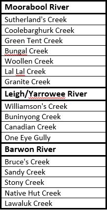
Regardless of which route the diggers chose, one thing was certain: at some point they would have to cross, walk alongside or take water from the the tributaries of the Barwon River. Whichever route they chose would require not just one, but numerous creek and river crossings. Whether at Batesford, Fyansford or east of Buninyong, the Moorabool River had to be crossed. Travelling via Shelford also meant crossing the Leigh/Yarrowee River at least twice, if not three times, not to mention the many creeks and gullies along the way. Below is a list of the main creeks along the three routes, grouped according to the river into which they flow.
In the early days before bridges were built, fording creeks and rivers was inevitable and bad weather could have a significant impact, not only on the road surface, but also on the ease with which a creek or river could be crossed - if it could be crossed at all. Newspaper reports of flooding often also came with reports of drownings, both of animals and humans as attempts were made to cross dangerously swollen creeks and rivers. Another reason for diggers to consider carefully which route to take.
There is one other factor which could also influence the decision and which could significantly alter the flow of traffic along a particular road: maps.
And some of those maps will be the topic of my next post.

13 April, 2016

Making tracks: the best line of road

Twenty-eight Miles from Geelong, near the Moorabool River, and on the best line of Road to Ballarat.
This was the rather bold claim made in September, 1853 by real estate agent J.B. Hutton who had been retained by Richard Coombs to sell the Eclipse Hotel, located some three and a half miles to the north of Steiglitz at the end of what is now Eclipse Rd. The Eclipse - as I have mentioned previously - was 'Durdidwarrah' (now 'Darra') the former homestead of Charles Augustus Von Steiglitz. It had been purchased by Richard Coombs who,  in April, 1853 stated that "Owing to the increasing traffic on this road, the want of accommodation has been so much complained of that a half way house has become a matter of necessity..."
Coombs further claimed that "the distance to Buninyong by this route is considerably shorter than by any other...[and that] the road having been the great thoroughfare in the winter season, notwithstanding the want of accommodation, proves the superiority,which is admitted by its now being generally taken by parties to and from the diggings."
Eclipse Rd between Steiglitz and 'Darra'
Clearly, by 1853 diggers were travelling to the goldfields at Ballarat and Buninyong via Steiglitz and the suggestion was that this road was a surer bet during the wet winter months when sections of the Geelong to Buninyong Track became all but impassable. It was also claimed that this route was "considerably shorter" than "any other", however I'm not sure this claim can be supported. The trip from Geelong to Steiglitz alone was around 40km (or around 25 miles in the old units). If the second half of the journey followed the route I suspect it did, then a further 51km (31 miles) would be required to complete the trip. A total of around 90km (56 miles).
By contrast, the total distance from Geelong to Buninyong via the track of that name was around 80km (or 50 miles) in total. Various newspaper articles over the years however, indicate that travellers were prepared to travel quite some distance out of their way to avoid bad roads, so whilst perhaps not the shortest route, it may well at times - like the track via Shelford - have been the easier, if not also the safer route to take.
Despite his grand plans, Coombs' tenure as landlord of the Eclipse was short-lived. By September, 1853 the property was once again on the market and in March the following year, was purchased by Mr William Birdsey, along with 33 acres of land and a number of outbuildings. Subsequent nearby land sales made the claim that the land stood on "the northern road to Buninyong and Ballarat", although the northern road from where, it did not state.
'Island Lodge', the home of Charles Augustus Von Stieglitz on his Durdidwarrah
Run, later the Eclipse Hotel. Image held by the Victorian State Library
Whilst perhaps not the main route to the goldfields, traffic during the 1850s would have fluctuated with the discovery of gold at places like Morrison's and Dolly's Creek. Although initial finds in these areas occurred in 1851, prospecting did not really take off until around 1857. Prior to this however, in 1853, the discovery of gold at Mt Egerton, almost 30km to the north of Steiglitz would also have resulted in an increase in traffic.
After quartz reef mining at Steiglitz took off in late 1855, traffic at least as far as Steiglitz would have increased dramatically too, and for those who could afford it, in March, 1856 the Criterion Conveyance Company indicated that they would be running a service from Geelong to Ballarat via Steiglitz, Meredith and Magpie Gully. By contrast, I can find no indication that a coach service operated between Steiglitz and Mt Egerton. It does however seem likely, that the route was popular with drays coming from Geelong. During a flood in October, 1855, it was noted that due to the water level of Wallace's Creek, dray communication between Egerton and Geelong via Steiglitz was at a virtual standstill.
I am unsure whether this route from the Eclipse to Buninyong has been documented elsewhere, but looking at the survey maps available online and considering a few relevant dates, I suspect I now have an idea of where this "northern road" ran and why it was used. Like the other tracks and roads which spread out across the countryside, this route was probably part of the network of bullock tracks which criss-crossed the countryside, leading from one squatter's run to the next.
The track to and from the Eclipse Hotel would originally have led to Charles Von Stieglitz' Durdidwarrah Run and after passing by the homestead continued north past Mr Hugh Morrison's pre-emptive selection at 'Moreep' to that of John Wallace of 'Ballark'.
Plaque at the Molesworth Bridge acknowledging John Wallace of 'Ballark'
An 1856 survey map of the Parish of Ballark shows a bush track running north-south and labelled as the "bush track from the Steiglitz". It intersected a second east-west track at the south east corner of Wallace's pre-emptive selection. This second "bush track to Geelong" closely followed the modern Meredith-Ballan Rd to its intersection with the Egerton-Ballark Rd around 800m to the east (see map below) before continuing east and then south east to intersect with the Geelong-Ballan Rd. It is also of interest to note that today's Bungeeltap South Rd was - according to the survey - originally intended to be the main Geelong-Ballan Rd.

A section of the 1856 Ballark Parish survey map overlaid on Google Earth.
The red lines show the bush track from Steiglitz and that from Geelong
Unfortunately, at this point the early maps online dry up, so I can only assume that the track roughly followed the Egerton-Ballark Rd through Wallace's pre-emptive selection, crossing the east branch of the Moorabool River and heading north west between the two branches of the river. I can find no mention of the river crossing itself, except perhaps the above reference to "Wallace's Creek" being so badly flooded that drays could not cross. It is possible - although I cannot confirm it - that this section of the Moorabool East Branch was known locally as Wallace's Creek at that time.
The Moorabool River East Branch at the Molesworth Bridge
 Regardless, a quick glance at Google Earth at this point will reinforce the Egerton-Ballark Rd as the most likely route north. The road can be seen to run along the ridge between the Moorabool West Branch and Bungal Creek. Travel on either side of these streams would be seriously restricted by some fairly hilly and inhospitable terrain in the form of the Mt Doran and Lal Lal State Forests to the west and the Bungal State Forest to the east, making the middle ground the more appealing option. A correspondent to the Bendigo Advertiser travelling south in December, 1855 described the route he took as passing the stations of Lal Lal, Egerton and Wallace which is also consistent with the above route.
Looking north west across the Moorabool East Branch near 'Ballark'
After traversing the high ground between the two waterways, I was again able to pick up the trail at the Yendon-Egerton Rd. This road - like many others in the area - follows an earlier track which is marked on an 1855 survey map as "from Lal Lal" at one end and "to Geelong" at the other. I cannot tell from the map whether the "Geelong" end continued to the west, or turned south, becoming the "missing" section of track from 'Ballark', however, to the west, the section of track shown on the map turns slightly to the north, as does the modern road, and crosses the Moorabool West Branch at the site of the Blue Bridge. Whilst the bridge may only date back to 1870, clearly the crossing was in use much earlier, probably dating back to the earliest days of European settlement, and if other sites are any indication, it may even have been used as a crossing by the local Tooloora balug clan of the Wathaurong who lived in the area.
Moorabool River West Branch, looking east towards the Blue Bridge
on the Yendon-Egerton Rd, October, 2013
Once across the river, the diggers found themselves on the Lal Lal Run, by that time in the hands of Archibald Fisken who by 1850 had taken over the property from his uncle Peter Inglis. At this point however, things become less clear. The early survey maps of Buninyong Parish show a bush track running to the north of Mt Buninyong, closely following the modern Yendon Number One Rd to Buninyong Rd and then intersecting the Midland Highway about 250m west of the present intersection.
It is not too much of a stretch to imagine that the track from Steiglitz, after crossing the Moorabool, continued through Fisken's property to become the track leading into Buninyong. Before the gold rush of course, Buninyong developed as a hub where those from the surrounding squatting runs could buy supplies without having to travel all the way to Geelong or Melbourne. No doubt the Peter Inglis and Archibald Fisken and their men made good use of this track to Buninyong over the years.
After the discovery of gold at Golden Point in 1851 however, the majority of traffic headed not for Buninyong, but further north to Ballarat where they would find themselves in the midst of those who chose to travel directly from Melbourne. For the latter diggers, there were a number of tracks which developed, the remnants of which can still be seen in some of the road names today. Most relevant to this post is the Old Melbourne Rd which runs from Ballan through Gordon, Millbrook and Dunnstown to Warrenheip. From at least the 1860s, this road was known as the "South Melbourne Rd to differentiate it from the more northerly road which followed a line to the north of
The track was typical in that after the discovery of gold, a string of public houses sprang up along this road to cater for those heading to the diggings. One such was the Spread Eagle Hotel, located on the north east corner of William Bacchus' pre-emptive selection. In The Argus of March, 1856 it was described as a "well-known roadside hotel", suggesting it had been in operation for some time.
The hotel - and this section of the track from Melbourne - lay about 5km north of the river crossing from Steiglitz on Fisken's land and a road (still known today as Spread Eagle Rd), ran north-south between the track to Buninyong and the track from Melbourne to Ballarat. It appears on survey maps as early as 1858 and may have provided a route for traffic from Geelong via Steiglitz to merge with that from Melbourne.
Google Earth image showing bush tracks on survey maps (red), the Old
Melbourne Rd (green) and likely connecting roads in between (blue)
For those looking for a more direct route, or who perhaps were not in need of sustenance at the Spread Eagle, another road surveyed by the 1850s branched off the Buninyong track immediately after it crossed the Lal Lal Creek further west. This road travelled north west, aligning with the modern Dunnstown-Yendon Rd which intersects the Old Melbourne Rd west of Dunnstown. Unsurprisingly, only a short distance further along, another public house - Pedrana's Saw Mill Hotel - also sprang up at the foot of Mt Warrenheip, near the pre-emptive selection held by Archibald Fisken as part of the Warreneep Run. The name of this establishment appears in the newspapers from the mid-1850s where it was the scene of a murder which received substantial media attention at the time.
Some idea of conditions can be gleaned from a traveller from Ballarat to Melbourne in 1859 who gives the impression that perhaps the road was not all as good as Mr J.B. Hutton, the real estate agent above would have had potential buyers of the Eclipse Hotel believe. The correspondent to The Star of 6th April, 1859 describes the section of road between Warrenheip and the Spread Eagle Hotel as being "horribly suggestive of all sorts of possibilities in the way of collisions and upsettings" and the crossing at Two Mile Creek he describes as an "awful chasm through which vehicles have to plunge".
Having survived the precipitous creek-crossing and the treacherous stretch of road leading to the Saw Mill Hotel, the diggers once again faced a decision. Depending on their intended destination, they could head a short distance further north to join with what became the Western Highway, entering Ballarat along Humffray St. As mentioned previously, this was a bullock track dating back to the earliest days of settlement at Ballarat and the main entrance to the town from Melbourne.
The other alternative was to turn south west and follow today's Warrenheip Rd along a meandering route to enter Ballarat via Eureka St - also one of the early bullock tracks. This latter route had the advantage of depositing the hopeful diggers directly to the Golden Point Diggings, rather than to the town centre which at that time was a short distance to the north at what is now Ballarat East. The popularity of this latter route is perhaps confirmed by yet another postulant for the title of "main route from Geelong to the diggings".
Looking along Eureka St, 1855 at the site of the infamous Bently's Hotel.
Image held by the National Library of Australia
This last contender comes in the form of the Victorian Heritage Database which makes the claim that "later the Warrenheip Road to Ballarat became the main goldfields route from Geelong" and further states in a report on the Buninyong Heritage Precinct that "Warrenheip Road [was] the early gold route from Geelong to the Ballarat gold fields".
Another claim and another slight difference in terminology. It would seem that this route did not become popular until "later". When that was, is not specified, however following the significant discoveries at Steiglitz, it is perhaps reasonable to assume that traffic between two of the largest goldfields in the colony, via all routes, would have increased dramatically when the discoveries at Steiglitz became known.

14 March, 2016

Making tracks: via Mt Mercer

I initially began researching the route travelled by the diggers who flocked to the goldfields of Buninyong, Ballarat and beyond after noticing that a number of towns located on the rivers, creeks and gullies of the Barwon catchment claimed to be on the "main gold route" or on the "best line of road" to the goldfields. But how could places as far apart as Teesdale on the Leigh Road and the Eclipse Hotel at Durdidwarrah and Morrisons, along with all the towns which sprang up along the Geelong to Buninyong Track, justify their claims?
It quickly became apparent that there were several different routes which hopeful prospectors could take to the diggings and each had its own claim to being "the main route from Geelong to Ballarat" (or Buninyong for the current purpose as all roads from Geelong passed through or near that town). The shortest route was certainly the bullock track which lead from Geelong to Buninyong. It was well established by the 1840s and had been used by the mail coaches to travel between Geelong and Buninyong since 1846. If volume of newspaper content is anything to go by, this was certainly the busiest route to the goldfields and the topic of my most recent posts.
Teesdale of course, is not on this route. It was however on the road taken by another of the earliest mail coaches in the district - the Portland Bay Mail Coach. The mail from Geelong (and from Melbourne via the steamer) was carried by coach through Leigh Road (Bannockburn), Teesdale, The Leigh (Shelford), Rokewood and onwards to join the Melbourne to Portland Bay mail at Fiery Creek (Streatham/Beaufort). An 1856 survey map of the Teesdale area describes this road as the "main road from Fiery Creek to Geelong via Batesford".
Shelford iron bridge under construction 1873-4. The timber pylons of the original
bridge are visible between those of the new bridge
Like the Geelong to Buninyong Track, the Portland Bay Road required travellers to undertake several river and creek crossings - the Moorabool River at Batesford, Bruce's Creek at Leigh Road and two crossings of the Leigh/Yarrowee River. The first of these was at The Leigh where, prior to 1850, the crossing was made via a ford. After this date, a wooden bridge was installed which served until 1873-4 when a wrought-iron box girder bridge was erected as per the design of Leigh Shire engineer C.A.C. Wilson.
After crossing the Leigh, those travelling to Buninyong needed to branch off the Portland Bay road and head north. First however, they could take a meal or stay overnight at the Settlers' Arms Inn, before following the track which lead to Mt Mercer and on to Buninyong. The inn was built in 1843 by Captain Francis Ormond who leased the surrounding land from George Russell of the Clyde Company, agreeing to improve the area and build the inn which soon prospered as a result of the passing trade.
Settler's Arms Inn built by Captain Francis Ormond in`1843. Situated near
the Shelford bridge across the Leigh River, the inn was a staging post on the
Portland Bay mail route. It was demolished in 1983 to allow construction
of the current road bridge. Image taken in 1975 is from the John T Collins
Collection, State Library of Victoria
Whilst none of the early maps such as those produced by surveyor AJ Skene (1845), Ham's map of the routes to the Mt Alexander & Ballarat diggings (1852) or Sands & Kenny's Map of Victoria (1859) show a road running from Shelford to Buninyong, the track did exist and it was used to access the goldfields. Survey maps as early as 1851, show the beginning of a road leading south from Buninyong "to The Leigh". It was not until 1857 however, that it was officially surveyed - at least in part - by government surveyor Maurice Weston and was indeed titled "part of Geelong and Ballarat Road from Shelford to Mt Mercer".
A dirt track leading into Shelford, taken during the late 19th century. Image held
by the State Library of Victoria
An important point of distinction however, which may also explain Teesdale's claim to be on the "main gold route" from Geelong to Ballarat, is a description which appears in the newspapers from the 1850s onwards, referring to the "main road from Geelong to Ballarat via Mt Mercer". It is probably telling that the description of this road always seemed to come with the qualifier "via Mt Mercer". I suspect this meant not that this was "the" main road, but rather that it was "a" main road and that it ran via Mt Mercer. In this era the phrase "government road" or "main government road" was often also used. It described official roads built and maintained by the government. From the 1860s, local road districts were established to levy rates and to maintain roads across the colony. The colonial government however, still retained responsibility for the most important roads, therefore a "main road" was any road which was paid for and maintained by the government rather than by the local road district or shire council. Having a road declared as a "main road" by the government could remove significant financial strain from a struggling rural shire.
Another consideration is the term "main gold route". Does this mean the route taken by the diggers to get to the goldfields or the route taken by the gold escorts bringing the gold back to Geelong? Newspaper reports show that the the contractors carrying gold to Geelong travelled via the Geelong to Buninyong Road. It was for this reason that a police paddock and associated buildings were established at Meredith in 1853 (and a little later also at Burnt Bridge), to provide a base for the police officers accompanying the gold; a staging post for changing horses.
This early photograph taken c1852-1854 shows the Ballarat gold escort. Image
held by the State Library of Victoria
Whilst it may have been shorter and there may have been more traffic on the Geelong to Buninyong Track, it was not without its problems. When the weather was bad, some sections of the road became a quagmire. Negotiating "Scott's Swamp" could prove an almost impossible prospect. The approach from Melbourne could also be a difficult journey; one traveller reported seeing hundreds of drays stranded in the mud during a single trip to the goldfields of Ballarat. It is probably no surprise then, that whilst researching a previous post, I found mention of the track from Shelford to Buninyong being used by travellers when the Geelong to Buninyong Track was impassable during bad weather.
It may have been longer, however travellers would go a significant distance out of their way to avoid bad roads, even taking to the bush when necessary.
It is also worth noting that the Geelong to Buninyong Road and the road via Mt Mercer did not exist in isolation from one another. They were connected by tracks (and later roads) which ran east-west between them. As I mentioned in an earlier post about the Green Tent, there was a track running from that place back to Shelford which was used by bullockies and those wanting to graze their stock, as well as the track which became the Meredith-Shelford Rd. If conditions were proving too difficult on one road, it was possible to veer off and head for the other.
And it is at this point that another local tale surfaces. Whilst on a visit to 'Narmbool' (the squatting property established in 1839 by Hugh Niven, now owned by Sovereign Hill), I was told that an old track leading down across Williamson's Creek was "used by the diggers during the gold rush". This would seem to be confirmed by a road marked on an 1892 geological survey map, running in a direct line between Horsehill Rd and Williamson's Creek along the fence line we were shown. After crossing the creek, survey maps of Clarendon Parish from 1915 show the road - presumably following the earlier track - continuing on to a fork. One branch ran north, following what today is a vague track which becomes Pryor's Rd, the other travelled only a short distance south west to Sand Rd. Both Sand and Pryor's Roads meet up again to the east of the mining town of Garibaldi before joining the Buninyong-Mt Mercer Rd. Thus the diggers could follow this road north to Buninyong or they could again join the Geelong to Buninyong Rd to the east of Scotsburn, or possibly further west, thus avoiding Scott's Swamp.
Local sources say that, a track used by diggers heading to the goldfields
(presumably from' the Geelong to Buninyong Rd) ran down the hill at the fence
line to cross Williamson's Creek at this point 
It is also worth remembering however that as the gold rush progressed, diggings spread out across the countryside. With the advent of large companies and deep lead mining towards the end of the 1850s, mines were established along the banks of the Yarrowee/Leigh River as far south as the Leigh Grand Junction Bridge and a little beyond. It makes sense therefore that by the time they were surveyed in 1857, that the Shelford-Mt Mercer Road and the subsequent Mt Mercer-Buninyong Rd would be the main access route for those heading from Geelong to the mining settlements along the river such as Garibaldi and Scotchman's Lead.
Looking at the survey maps available from the 1850s for the parish of Enfield, the old track by and large, followed the same course as the modern road, although where the modern road veers to the west to meet the road from Dereel, the old track stayed close to the river past Mt Mercer. Further north near Garibaldi, the track again followed a slightly different course, crossing the Yarrowee River about 700m north west of the present crossing which was not built until 1866. As I described in an earlier post, the river crossing at Garibaldi was dangerous, with three people said to have lost their lives during flooding prior to the erection of the bridge downstream.
Google Earth image showing: modern roads (yellow), Buninyong-Mt Mercer
Track (green), unused road on 'Narmbool' (blue), other pre-survey tracks (red).
Click to enlarge
Unfortunately the only 1850s survey map which I am currently able to access is that for Enfield Parish, so I am uncertain of the exact path of the original track to the north or south of this area. It does appear however, that the entry to Buninyong was intended to be via a more direct line one block to the east of the current alignment, which makes me wonder if perhaps Sandys Hill Rd (which intersects the road to The Leigh as marked on the survey map), may have been part of the original track from Mt Mercer.
It is also worth remembering that there may well have been other informal crossing points along the Leigh/Yarrowee which also gave access for those heading to the goldfields. I know of at least one bridge which no longer exists, but which was used by workers crossing to 'Golfhill'. Located at the end of Henderson's Rd, Bamganie, it was a timber swing bridge which existed into the 20th century, however I am unsure of its age. Similarly, there is a small bridge on Kelly's Rd, Grenville where the Leigh can be crossed, however the road itself does not appear on the earliest survey maps.
No doubt there were other crossing points and tracks along the way, all of which could have been used by those travelling to and from the goldfields to reach the road between Buninyong and Shelford.
If at any point I find more detail I will update this post accordingly.