Showing posts with label Durdidwarrah. Show all posts

17 May, 2016

Songlines of the Barwon Catchment

During the recent Mountain to Mouth 2016 extreme arts walk held across the City of Greater Geelong and the Borough of Queenscliffe, one of the catchphrases used was "walk this land". Participants were encouraged to consider those who have walked the land before us. Part of our route took us along the Barwon River, with the event ultimately concluding on the banks of the river at Barwon Heads.
With this in mind, I thought I would have a look at the lands of the wider Barwon catchment and the people who have walked them. The way we cross the land today is perhaps best represented by maps. For thousands of years before the arrival of Europeans however, the indigenous tribes of Australia walked the land, following ancient tracks and pathways known to their ancestors, without the benefit of modern cartographic techniques.
For 25,000 years prior to the arrival of Europeans, the Barwon catchment was home to three indigenous tribes. The lands surrounding the lower Barwon - downriver from Winchelsea - as well as the catchments of the Moorabool and Leigh/Yarrowee Rivers were occupied by the Wathaurong (Wadawurrung) people. The lands of the Gulidjan Tribe lay along the upper reaches of the Barwon, also incorporating the area around Lake Colac. The Barwon itself formed the boundary between the Gulidjan people and their southern neighbours - the Gadubanud Tribe - who lived on the land between the river and the coast, stretching westwards past Cape Otway.
Adaption of the map "Catchments of the Barwon River and inland Basins", created
by the Victorian State Rivers and Water Supply Commission, 1950 (original
image held by the State Library of Victoria). Clan territories estimated from
Clark, 1995, "Scars in the Landscape"
Rather than physical maps such as the one above, indigenous maps were shared through dance, song, painting and story. They talked about the features of the land itself; the rivers and creeks which showed them the way from one place to another, the hills, the trees, the rocks, the waterholes passed along the way. Even the sky played a role. Following these "songlines", it was possible to walk for hundreds of kilometres. In this way, people could move between tribes, establish trade routes, make marriages, manage natural resources; walking - it was believed - in the footsteps of the creator spirit.
And it isn't too much of a stretch to see how songlines could work. The name of the Barwon itself is a directional description. Barre Warre N Yallock - the big river which flows from the mountains to the sea. Follow this river and you will reach the sea. Kooly bar ghurk (Coolebarghurk): man's track by the creek. Another descriptive name. Which track? The one by the creek. The one made by people, not the many animal tracks which no doubt criss-crossed the land.
"Man's track by the creek". For thousands of years, the Wathaurong walked the
banks of Coolebarghurk Creek
Wormbete: which lake? The "lake with the black fellow's mound". Where? Bukar Bulac; the place between two rivers. This was the Wathaurong name for the confluence of the Moorabool and Barwon Rivers.
Creation stories told how the eagle Bundjil looked down upon the world from the sky where his fire (the planet Jupiter) could be seen from Earth. Bundjil it was said, made his earthly home at Woringganninyoke - Lal Lal Falls. Whilst the meaning of the first name is unknown, "Lal Lal" is said to mean "dashing water in a crevice". Another literal description which could contribute to a songline.
Lal Lal Falls, April, 2012
Many other sites were named for prominent features which could also be used as part of a songline. Someone wanting to journey north west from Jillong (Geelong), the "place of native companions" or the place "where the seabirds fly over white cliffs", could perhaps travel to Durdidwarrah where either a "shelter of bark" or "dead water" could be found after which they would reach Bungeeltap (meaning either "spirit water" or "eagle's nest"). From there, they could see [Mount] Warrengeep (Warrenheip) where the ferns of the side of the mount resembled "emu feathers" before passing Bonan Yowing (Buninyong), the mountain shaped like a "man lying on his back with his knee raised." Once there, it wasn't too far to Balla arat (Ballarat), the "reclining on the elbow" "place" or resting place.
Bonan Yowing: Mt Buninyong, visible across the surrounding countryside
for many kilometres
Like today's Google Maps, the songlines of the indigenous peoples not only described which route to follow, but gave tips about where to stay and what food could be found along the journey: Yarram Mordong (the Wathaurong name for Buckley Falls), waterfall [of] eels; Porrong Goop (Borrongoop), the place of quails; Koo N Warre (Lake Connewarre), mud oyster water.
Koo N Warre: Lake Connewarre
In this way, the Wathaurong, Gulidjan and Gadubanud Tribes of the Barwon catchment "mapped" out the land, preserving their knowledge over thousands of years for future generations. Until European settlers arrived...

13 April, 2016

Making tracks: the best line of road

Twenty-eight Miles from Geelong, near the Moorabool River, and on the best line of Road to Ballarat.
This was the rather bold claim made in September, 1853 by real estate agent J.B. Hutton who had been retained by Richard Coombs to sell the Eclipse Hotel, located some three and a half miles to the north of Steiglitz at the end of what is now Eclipse Rd. The Eclipse - as I have mentioned previously - was 'Durdidwarrah' (now 'Darra') the former homestead of Charles Augustus Von Steiglitz. It had been purchased by Richard Coombs who,  in April, 1853 stated that "Owing to the increasing traffic on this road, the want of accommodation has been so much complained of that a half way house has become a matter of necessity..."
Coombs further claimed that "the distance to Buninyong by this route is considerably shorter than by any other...[and that] the road having been the great thoroughfare in the winter season, notwithstanding the want of accommodation, proves the superiority,which is admitted by its now being generally taken by parties to and from the diggings."
Eclipse Rd between Steiglitz and 'Darra'
Clearly, by 1853 diggers were travelling to the goldfields at Ballarat and Buninyong via Steiglitz and the suggestion was that this road was a surer bet during the wet winter months when sections of the Geelong to Buninyong Track became all but impassable. It was also claimed that this route was "considerably shorter" than "any other", however I'm not sure this claim can be supported. The trip from Geelong to Steiglitz alone was around 40km (or around 25 miles in the old units). If the second half of the journey followed the route I suspect it did, then a further 51km (31 miles) would be required to complete the trip. A total of around 90km (56 miles).
By contrast, the total distance from Geelong to Buninyong via the track of that name was around 80km (or 50 miles) in total. Various newspaper articles over the years however, indicate that travellers were prepared to travel quite some distance out of their way to avoid bad roads, so whilst perhaps not the shortest route, it may well at times - like the track via Shelford - have been the easier, if not also the safer route to take.
Despite his grand plans, Coombs' tenure as landlord of the Eclipse was short-lived. By September, 1853 the property was once again on the market and in March the following year, was purchased by Mr William Birdsey, along with 33 acres of land and a number of outbuildings. Subsequent nearby land sales made the claim that the land stood on "the northern road to Buninyong and Ballarat", although the northern road from where, it did not state.
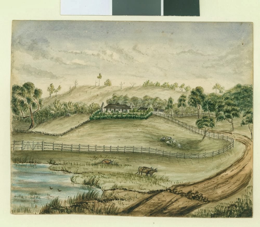
'Island Lodge', the home of Charles Augustus Von Stieglitz on his Durdidwarrah
Run, later the Eclipse Hotel. Image held by the Victorian State Library
Whilst perhaps not the main route to the goldfields, traffic during the 1850s would have fluctuated with the discovery of gold at places like Morrison's and Dolly's Creek. Although initial finds in these areas occurred in 1851, prospecting did not really take off until around 1857. Prior to this however, in 1853, the discovery of gold at Mt Egerton, almost 30km to the north of Steiglitz would also have resulted in an increase in traffic.
After quartz reef mining at Steiglitz took off in late 1855, traffic at least as far as Steiglitz would have increased dramatically too, and for those who could afford it, in March, 1856 the Criterion Conveyance Company indicated that they would be running a service from Geelong to Ballarat via Steiglitz, Meredith and Magpie Gully. By contrast, I can find no indication that a coach service operated between Steiglitz and Mt Egerton. It does however seem likely, that the route was popular with drays coming from Geelong. During a flood in October, 1855, it was noted that due to the water level of Wallace's Creek, dray communication between Egerton and Geelong via Steiglitz was at a virtual standstill.
I am unsure whether this route from the Eclipse to Buninyong has been documented elsewhere, but looking at the survey maps available online and considering a few relevant dates, I suspect I now have an idea of where this "northern road" ran and why it was used. Like the other tracks and roads which spread out across the countryside, this route was probably part of the network of bullock tracks which criss-crossed the countryside, leading from one squatter's run to the next.
The track to and from the Eclipse Hotel would originally have led to Charles Von Stieglitz' Durdidwarrah Run and after passing by the homestead continued north past Mr Hugh Morrison's pre-emptive selection at 'Moreep' to that of John Wallace of 'Ballark'.
Plaque at the Molesworth Bridge acknowledging John Wallace of 'Ballark'
An 1856 survey map of the Parish of Ballark shows a bush track running north-south and labelled as the "bush track from the Steiglitz". It intersected a second east-west track at the south east corner of Wallace's pre-emptive selection. This second "bush track to Geelong" closely followed the modern Meredith-Ballan Rd to its intersection with the Egerton-Ballark Rd around 800m to the east (see map below) before continuing east and then south east to intersect with the Geelong-Ballan Rd. It is also of interest to note that today's Bungeeltap South Rd was - according to the survey - originally intended to be the main Geelong-Ballan Rd.

A section of the 1856 Ballark Parish survey map overlaid on Google Earth.
The red lines show the bush track from Steiglitz and that from Geelong
Unfortunately, at this point the early maps online dry up, so I can only assume that the track roughly followed the Egerton-Ballark Rd through Wallace's pre-emptive selection, crossing the east branch of the Moorabool River and heading north west between the two branches of the river. I can find no mention of the river crossing itself, except perhaps the above reference to "Wallace's Creek" being so badly flooded that drays could not cross. It is possible - although I cannot confirm it - that this section of the Moorabool East Branch was known locally as Wallace's Creek at that time.
The Moorabool River East Branch at the Molesworth Bridge
 Regardless, a quick glance at Google Earth at this point will reinforce the Egerton-Ballark Rd as the most likely route north. The road can be seen to run along the ridge between the Moorabool West Branch and Bungal Creek. Travel on either side of these streams would be seriously restricted by some fairly hilly and inhospitable terrain in the form of the Mt Doran and Lal Lal State Forests to the west and the Bungal State Forest to the east, making the middle ground the more appealing option. A correspondent to the Bendigo Advertiser travelling south in December, 1855 described the route he took as passing the stations of Lal Lal, Egerton and Wallace which is also consistent with the above route.
Looking north west across the Moorabool East Branch near 'Ballark'
After traversing the high ground between the two waterways, I was again able to pick up the trail at the Yendon-Egerton Rd. This road - like many others in the area - follows an earlier track which is marked on an 1855 survey map as "from Lal Lal" at one end and "to Geelong" at the other. I cannot tell from the map whether the "Geelong" end continued to the west, or turned south, becoming the "missing" section of track from 'Ballark', however, to the west, the section of track shown on the map turns slightly to the north, as does the modern road, and crosses the Moorabool West Branch at the site of the Blue Bridge. Whilst the bridge may only date back to 1870, clearly the crossing was in use much earlier, probably dating back to the earliest days of European settlement, and if other sites are any indication, it may even have been used as a crossing by the local Tooloora balug clan of the Wathaurong who lived in the area.
Moorabool River West Branch, looking east towards the Blue Bridge
on the Yendon-Egerton Rd, October, 2013
Once across the river, the diggers found themselves on the Lal Lal Run, by that time in the hands of Archibald Fisken who by 1850 had taken over the property from his uncle Peter Inglis. At this point however, things become less clear. The early survey maps of Buninyong Parish show a bush track running to the north of Mt Buninyong, closely following the modern Yendon Number One Rd to Buninyong Rd and then intersecting the Midland Highway about 250m west of the present intersection.
It is not too much of a stretch to imagine that the track from Steiglitz, after crossing the Moorabool, continued through Fisken's property to become the track leading into Buninyong. Before the gold rush of course, Buninyong developed as a hub where those from the surrounding squatting runs could buy supplies without having to travel all the way to Geelong or Melbourne. No doubt the Peter Inglis and Archibald Fisken and their men made good use of this track to Buninyong over the years.
After the discovery of gold at Golden Point in 1851 however, the majority of traffic headed not for Buninyong, but further north to Ballarat where they would find themselves in the midst of those who chose to travel directly from Melbourne. For the latter diggers, there were a number of tracks which developed, the remnants of which can still be seen in some of the road names today. Most relevant to this post is the Old Melbourne Rd which runs from Ballan through Gordon, Millbrook and Dunnstown to Warrenheip. From at least the 1860s, this road was known as the "South Melbourne Rd to differentiate it from the more northerly road which followed a line to the north of
The track was typical in that after the discovery of gold, a string of public houses sprang up along this road to cater for those heading to the diggings. One such was the Spread Eagle Hotel, located on the north east corner of William Bacchus' pre-emptive selection. In The Argus of March, 1856 it was described as a "well-known roadside hotel", suggesting it had been in operation for some time.
The hotel - and this section of the track from Melbourne - lay about 5km north of the river crossing from Steiglitz on Fisken's land and a road (still known today as Spread Eagle Rd), ran north-south between the track to Buninyong and the track from Melbourne to Ballarat. It appears on survey maps as early as 1858 and may have provided a route for traffic from Geelong via Steiglitz to merge with that from Melbourne.
Google Earth image showing bush tracks on survey maps (red), the Old
Melbourne Rd (green) and likely connecting roads in between (blue)
For those looking for a more direct route, or who perhaps were not in need of sustenance at the Spread Eagle, another road surveyed by the 1850s branched off the Buninyong track immediately after it crossed the Lal Lal Creek further west. This road travelled north west, aligning with the modern Dunnstown-Yendon Rd which intersects the Old Melbourne Rd west of Dunnstown. Unsurprisingly, only a short distance further along, another public house - Pedrana's Saw Mill Hotel - also sprang up at the foot of Mt Warrenheip, near the pre-emptive selection held by Archibald Fisken as part of the Warreneep Run. The name of this establishment appears in the newspapers from the mid-1850s where it was the scene of a murder which received substantial media attention at the time.
Some idea of conditions can be gleaned from a traveller from Ballarat to Melbourne in 1859 who gives the impression that perhaps the road was not all as good as Mr J.B. Hutton, the real estate agent above would have had potential buyers of the Eclipse Hotel believe. The correspondent to The Star of 6th April, 1859 describes the section of road between Warrenheip and the Spread Eagle Hotel as being "horribly suggestive of all sorts of possibilities in the way of collisions and upsettings" and the crossing at Two Mile Creek he describes as an "awful chasm through which vehicles have to plunge".
Having survived the precipitous creek-crossing and the treacherous stretch of road leading to the Saw Mill Hotel, the diggers once again faced a decision. Depending on their intended destination, they could head a short distance further north to join with what became the Western Highway, entering Ballarat along Humffray St. As mentioned previously, this was a bullock track dating back to the earliest days of settlement at Ballarat and the main entrance to the town from Melbourne.
The other alternative was to turn south west and follow today's Warrenheip Rd along a meandering route to enter Ballarat via Eureka St - also one of the early bullock tracks. This latter route had the advantage of depositing the hopeful diggers directly to the Golden Point Diggings, rather than to the town centre which at that time was a short distance to the north at what is now Ballarat East. The popularity of this latter route is perhaps confirmed by yet another postulant for the title of "main route from Geelong to the diggings".
Looking along Eureka St, 1855 at the site of the infamous Bently's Hotel.
Image held by the National Library of Australia
This last contender comes in the form of the Victorian Heritage Database which makes the claim that "later the Warrenheip Road to Ballarat became the main goldfields route from Geelong" and further states in a report on the Buninyong Heritage Precinct that "Warrenheip Road [was] the early gold route from Geelong to the Ballarat gold fields".
Another claim and another slight difference in terminology. It would seem that this route did not become popular until "later". When that was, is not specified, however following the significant discoveries at Steiglitz, it is perhaps reasonable to assume that traffic between two of the largest goldfields in the colony, via all routes, would have increased dramatically when the discoveries at Steiglitz became known.

04 April, 2016

Making tracks: the Colonel and the one-armed shepherd

With the advent of the gold rush in 1851, diggers flocked to the goldfields of Ballarat and surrounds. In previous posts I followed their path from Geelong via the Geelong-Buninyong Rd and the track from The Leigh (Shelford) to Buninyong. In addition to these routes, there was also a third option, one which a hopeful real estate agent in the Geelong Advertiser and Intelligencer of 13th October, 1853 claimed was "the best line of road to Ballarat, Canadian Gully, Jeweller's Flat & c".
The road in question lay to the east of the Geelong to Buninyong Track, following a similar line to today's Steiglitz Road. After cresting Bell Post Hill, the route led towards Batesford, but instead of following the main road down into the Moorabool Valley, those wishing to take the other road to the east, took the track towards Steiglitz. Other than the above advertisement however, there is little mention of the route before October, 1855 when Steiglitz became a significant destination of its own. According to the Geelong Advertiser and Intelligencer of 16th October, 1855:
The shortest road from Geelong [to the new goldfield at Steiglitz] is to pass Colonel Kelsall's Station, cross Sutherland's Creek, follow the well defined dray road to the left of the creek till you come to the old shepherd's hut, when you are within two and a half miles from the diggings, which are situated on a point or tongue of land between Sutherland's Creek and a tributary creek flowing from the Anakies.
Sounds simple enough, but who were the Colonel and the shepherd?
The colonel was Roger Kelsall, engineer, sailor and then squatter who, according to fellow squatter Thomas Manifold, arrived in the district in the spring of 1836 and took up land on the upper parts of Sutherland's Creek. Prior to his arrival, Kelsall served as Clerk of Works at Port Arthur and was responsible for the design and construction of several of the buildings there. It was not however, until 1845 that he sold his commission with the Royal Navy and retired to Victoria. During this time I believe his run on Sutherland's Creek was maintained for him by a manager named Sharp.
The grave of Colonel Roger Kelsall, his wife Ann and son Roger
at the Eastern Cemetery
 By December, 1854, Kelsall had converted part of his lease into 1,490.5 acres of purchased land - including his pre-emptive right of 640 acres. The latter lay nestled between the left and right branches of Sutherland's Creek down to their confluence, with the rest of the land in several blocks on either side of both branches branch. He gave this property the name 'Chesterdale'. Additionally, the Colonel also purchased 557 acres of land lower down Sutherland's Creek on the west bank, directly opposite the Hope's land. This property, 'Strathey', eventually extended to 1,100 acres by the time both properties were subdivided and sold in 1908. Until that point, they had remained in the hands of the Kelsall family, however not long after the death of the Colonel in 1861, they were leased out to local graziers.
Contrary to the above description of the route, a look at the survey maps shows that the diggers would first have crossed first through the Hope's 'Darriwill' property before crossing the creek onto Colonel Kelsall's 'Strathey' and joining the bullock track. The creek crossing was presumably near the site of today's Hope's Bridge on the Steiglitz Rd. Clearly, the current bridge is not the original, that bridge stood slightly upstream of the modern one. The concrete and bluestone buttresses of the old bridge and various related timbers can still be seen just north of the existing bridge.
Looking upstream at the abutments and some remaining timber and concrete
at the site of the original Hope's Bridge
The earliest mention I can find of a bridge at this site is 1863, when drains were installed on the nearby road. In 1865 when the decking timbers were being replaced, it was discovered that the timbers beneath were rotten and in need of attention, indicating that the bridge had probably been in existence for some years at that time. Other timber bridges I have researched seem to have had a lifespan of around 10 years before structural timbers needed replacing, which might indicate that the bridge dated back to the 1850s. As far as I can tell, two bridges were erected on the Steiglitz Rd. One in 1857 and one in 1858. The latter was on the "Approach to Steiglitz gold-field" so perhaps this was the erection of the Five Mile Bridge, much closer to Steiglitz, whilst the bridge built in 1857 was at the crossing between Hope's and Kelsall's - but that is speculation. Whether an earlier structure such as a ford existed at the site, I don't know.
Looking east across Sutherland's Creek and the original Hope's Bridge
towards 'Darriwill'
After crossing the creek and making their way through Colonel Kelsall's property, it was - according to the above article - a simple matter of following the dray road on the left of Sutherland's Creek, towards the diggings. Other than the above reference however, I can find no mention of a road to Steiglitz before November, 1855, but presumably the dray track mentioned, led originally to the Durdidwarrah squatting run of Charles Augustus Stieglitz.
Another description of the trip to the new goldfield at Steiglitz which appeared a few months later in the Geelong Advertiser and Intelligencer, 28th January, 1856, was perhaps not quite so flattering, but provided a little more detail about the route:
"the road from Geelong to Steiglitz leads, for the first ten miles, through an open and slightly undulating country, the aspect of which is, of course, monotonius(sic) enough. Passing this space you arrive at Sutherland's Creek, now a chain of waterholes not particularly limpid. Next comes a tract of thinly timbered land, terminating in an open piece of rising ground known as the Bald Hill. Beyond this point and within eight miles of the "diggings," you pass in a close succession three refreshment tents, recently pitched, and a weatherboard establishment of a similar character not yet completed. A mile or two further on you find yourself suddenly in the gold country. The rapidity of the transition here is very remarkable. The easy undulations of the soil which prevail in the early portions of the journey give place at once to short and abrupt hillocks, pretty well timbered, and sprinkled over with great quantities of grass...
Being summer, it seems that there was little water in the creek. I can find no other mention of the "Bald Hill", however from context would expect it to be somewhere near what would (by 1856) become the township of Maude. At this point it is also worth remembering the "Buninyong Road from Melbourne" - described in my post "All Roads Lead to the Green Tent" - which intersected the Geelong to Buninyong Track at the Green Tent. This east-west track dating back to the 1840s, also crossed the track to Steiglitz, probably at Thompson Rd, Maude, as evidenced by an 1857 survey map which marks this road as "towards Melbourne". For those not wanting to make the steep climb in and out of the Moorabool Valley at this point, the Steiglitz route provided an alternative for those travelling from Melbourne.
From November, 1855 however, Steiglitz itself became a destination with the discovery of extensive gold reefs, making the track from Geelong even more popular.
Remaining brickwork footings of the United Albion Mine, Steiglitz
Not surprisingly, the sudden increase in traffic heading up the Steiglitz dray road resulted in the establishment of a "close succession of refreshment tents". They were probably similar to those which sprang up on the Geelong-Buninyong Track in the earliest days of the gold rush to Ballarat.
As far as I am aware, prior to the rush to Steiglitz there was no public house between Batesford and these new diggings.
Within a very short time however, that changed. In addition to the "coffee tents", an array of traders scrambled to set up shop in Steiglitz. According to the Geelong Advertiser and Intelligencer, by the first week of January, 1856, tents and stores were popping up by the dozen. As well as the essential butchers, bakers and general stores, hotels were quickly established. Upcoming applications for new liquor licenses advertised in February, 1856 included five for Steiglitz and a further two for Sutherland's Creek, all no doubt capitalising on on the traffic heading up the dray track to the goldfield.
Once past the "coffee tents" as noted, the terrain changed and became more rugged, signalling the presence of auriferous ground. From the turn off to Melbourne, the track fell away, down to a second crossing of Sutherland's Creek, this time at Five Mile Bridge and it was here, several newspaper accounts indicated, that the "one-armed shepherd's hut" could be found. Various reports shared around the colony, stated that a gold reef had been struck near the one-armed shepherd's hut, after crossing Sutherland's Creek, about 20 miles from Geelong.
The bed of Sutherland's Creek. During the 1850s numerous gold mines
operated along the banks of the creek
But who was the one-armed shepherd? Well, despite my best efforts, I have not been able to discover a name. In addition to his hut being a common point of reference on the road to Steiglitz, it was reported that on 21st January, 1856 he was the victim of a robbery, when three armed men known to be from the nearby diggings invaded his hut. Neither his name, nor indeed his presence at the time of the robbery, were not mentioned.
Once past the shepherd's hut, it was only a matter of a few more miles to Steiglitz, if that was the digger's intended destination; and for many, from October, 1855 it was. By December that year, a coach was running from Geelong to Steiglitz, carrying those who could afford it. In fact, within a short space of time, Steiglitz became a staging post for the coaches running to and from Geelong and the goldfields.
The view down Regent St towards the site of Cobb & Co.'s
staging post (left), April, 2010
But Steiglitz was not the end of the journey for every digger. Indeed, prior to October, 1855 it was just another creek crossing on the way to Buninyong, and later, Ballarat. It was also roughly the half way point on this eastern path to the diggings and according to some, was crying out for a public house; a stopping point along the road, where the drays carrying supplies to the goldfields of Ballarat and Buninyong and a little later to places such as Mt Wallace, Mt Egerton, Dolly's Creek and Morrisons, could spend the night or break their journey with a meal.
That need was filled in April 1853, when Richard Coombs announced that he had purchased the mansion until recently owned by Charles Von Stieglitz and converted it for use as an hotel...

23 September, 2015

Branching out - silting up

On 1st July, 1851 two things occurred which changed the face of the Barwon catchment forever. On that date, Victoria was declared a separate colony from New South Wales and gold was discovered at Clunes on Creswick Creek, a tributary of the Lodden River. Five days later, James Esmond arrived in Geelong with samples of the gold found by himself and his two companions. Two days after that, the Geelong Advertiser published the news. By the end of the month, the Victorian gold rush had begun.
The first gold discovery in the Barwon catchment occurred only weeks after the initial discovery at Clunes on 8th August.
Information board near the site of Hiscock's first gold
discovery, situated roughly opposite the Buninyong Cemetery.
On that day, Thomas Hiscock - a blacksmith who had migrated from England ten years before - discovered gold in a gully which now bears his name, in the Buninyong Ranges west of the town.
Like the many creeks and gullies in the area, Hiscock's Gully ultimately drains into the Yarrowee/Leigh River and empties into the Barwon River at Inverleigh.

A memorial erected some distance to the east of the above
sign and which commemorates Hiscock's discovery
Ten days later, gold was also discovered at Poverty Point, Ballarat, on the banks of Canadian Creek only a few hundred metres from its confluence with the Yarrowee River. Within a matter of months around 20,000 hopeful prospectors had flocked to the region to work the easily accessible alluvial deposits.
Sign describing the first Ballarat gold discovery and
subsequent events
This initial rush was followed in subsequent years by the arrival of the big mining companies with the heavy equipment used to mine the deeper quartz reefs of the district. This saw excavation along the Leigh/Yarrowee, extend downstream past Garibaldi to the Leigh Grand Junction and beyond. 
The impact on the river and the creeks and gullies which flow into it was profound. The initial alluvial mining saw a significant reduction in the native vegetation as trees were cleared to make way for mining exploits or harvested for use in construction of the necessary infrastructure. Across the upper part of the catchment, the miners dug into the banks of the waterways, diverted water flows and turned over the soils of the creeks and river flats of the catchment. As they worked, large piles of discarded timber from felled trees washed downstream, causing logjams and impeding water flow. At the same time tonnes of rock and soil were displaced, leaving huge piles of tailings or mullock heaps littering the landscape.
Consequently, as early as the 1860s, the finer sediments from these deposits began to wash into the waterways and make their way into the Yarrowee River before working their way downstream towards the Barwon. On 29th October, 1869 a correspondent to the Geelong Advertiser wrote that:
For a number of years residents on and near the banks of the [Leigh River], and also those on that part of the Barwon below Inverleigh, have quietly looked upon their lands becoming impoverished by the settlement of silt upon them. The effect of the late flood, however, places the matter in a very serious light, and calls for immediate action. Beautiful flats of rich black soil have been converted into beds of clay, and that of the very worst description. Farms that a few years ago would have been suitable for the most exhaustive crops, are now rendered by the accumulation of sludge unfit for the production of grass....The bed of the river is rapidly filling up, consequently such floods must be more frequent and more disastrous.
By 1906 a Sludge Abatement Board had been established to monitor the water quality of rivers and was being called upon to address the complaints of the shires downstream on the Leigh which continued to bear the brunt of the problem. The sludge could be anywhere from about 45 - 180cm thick, with the largest deposits occurring on river bends. As the sediment flowed downstream and filled in pools and hollows, the rate of flow and the volume of the channel would also have decreased.
This image of the Yarrowee Dredging Co mine, 1889 (possibly the Yarrowee
Creek No 1 Gold Dredging Co) shows the degree of deforestation and erosion
caused by mining activity along the river. Image held by the
State Library of Victoria
In recent years, reports commissioned by the Corangamite Catchment Management Authority have confirmed what was evident 150 years ago. Modern understanding of the way vegetation affects hydrology, has also revealed the role deforestation must have played in increasing the quantity and rate at which runoff water entered the river. Today, the silts which were deposited after the beginning of the gold rush are referred to as Post Mining Alluvium and form the surface layer of soil in the area around Shelford and Inverleigh.
Meanwhile over on the Moorabool River, gold was also the order of the day, although the discovery and subsequent mining boom was a little later in coming. Gold was first discovered on the Durdidwarrah property of Augustus von Stieglitz in 1851, however the quantities were not considered workable. Some activity ensued in 1853 when Andrew Love and George Morton discovered alluvial gold on Sutherland's Creek, however, it was not until 1855 when William Hooley and Joseph Davis discovered a gold reef on Sutherland's Creek near Steiglitz that the rush really began.
From 1855 onwards, alluvial gold was extracted at various creeks and gullies along the Moorabool River including Sutherland's Creek, Dolly's Creek, Tea Tree Creek, Mt Doran, the Stony Rises (Elaine) and from the banks of the Moorabool itself at Morrison's however it was not until the 1860s that the large companies moved in and reef mining began in earnest.
The remaining brick footings of the United Albion Mine near Steiglitz
It seems however that the threat of a sludge deluge such as that seen on the Leigh, was not as much of an issue for the Moorabool River. Perhaps this is a reflection of the relatively greater proportion of reef mining in comparison to alluvial activity on the Moorabool.
It is interesting to note that a 2006 report commissioned for the Corangamite Catchment Management Authority showed that despite the greater water flow of the Barwon and the historic issues of increased sedimentation due to mining activities along the Leigh, it is the Moorabool which makes the greatest contribution to sediment deposited downstream at Lake Connewarre. There is no indication that this is related to earlier mining activities, instead it is postulated that the greater overall change in gradient along its length (by comparison with the Barwon and the Leigh) may account for the difference.

16 November, 2013

Branching out - a Bavarian invasion


The von Stieglitz family of Tasmania and Victoria were descended from Christian Ludwig von Stieglitz who was created Baron of the Holy Roman Empire in 1765. The second baron - Heinrich Ludwig - son of Christian emigrated from Bavaria to Ireland with his family around the turn of the 18th century. However, following the death of the second baron in 1824, his wife, six sons and three daughters found themselves in straitened circumstances, consequently each of the six grandsons at one time or another sought their fortune in Australia. Biographical details for each can be found in the Australian Dictionary of Biography.
Of particular relevance to the Moorabool Valley are the three brothers - Robert William, John Lewis and the youngest - Charles Augustus. Robert along with his brothers Frederick and Francis arrived in Tasmania in 1829, with the others following in subsequent years. Unlike their brothers, John and Robert did not receive land grants in Tasmania but instead crossed Bass Strait with the earliest squatters to take up land in the Port Phillip district.
On 9th November, 1835, John von Stieglitz along with John Anthony Cowie and David Vere Stead were amongst the first settlers lead by John Batman to land stock at Port Phillip. They arrived from Tasmania on the ship Norval, landing at Gellibrand's Point (Williamstown).
von Stieglitz, Cowie and Stead were quick to head west in search of pasturage for their stock. In March, 1836, Cowie and Stead - I assume with the von Stieglitz's - took up a run at what is now the suburb of Bell Post Hill in Geelong, holding the land which ran down to the Moorabool River (see Branching out - from squatting to schooling).
About two months later on 3rd May, John von Stieglitz married John Cowie's sister Emma at her brother Robert's home in Tasmania. Soon after on the 9th July, he arrived at Point Henry with more stock for their run.
By 1838 - already finding the rapid increase in population occurring with the settlement of the town of Geelong too restrictive - the brothers, along with Cowie and Stead moved their stock on to greener pastures further up the Moorabool River. Robert settled his sheep on 4,836 acres which he called Ballan (named for a town in Ireland) near the head of the eastern branch of the Moorabool River.
Ballan House, drawn by Emma von Stieglitz (nee Cowie). Image held by the
State Library of Victoria
Brother John and his wife Emma established themselves on 16,000 acres which they called Ballanee (aka Ballenee) nearby on the Werribee River. In 1842, ties between the von Stieglitz and Cowie families were further strengthened when John Cowie married the von Stieglitz brothers' youngest sister Charlotte Christina at Ballanee.
Ballanee, drawn by Emma von Stieglitz, Image held by the State Library of Tasmania
 Four years before his marriage, Cowie along with David Stead had taken up a third run, south of Ballan on the banks of the East Moorabool River. They called their property Bungeeltap - also the subject of an earlier post.
The third of the von Stieglitz brothers to take up a run on the Moorabool was the youngest son, Charles Augustus. He arrived in Victoria in 1839, having stayed behind in Ireland to complete his schooling. Prior to his arrival, and the same year in which they were establishing the original Bell Post Hill run near Geelong, Cowie and Stead also  took up a lease of 8,000 acres further up the Moorabool on its eastern bank. This land lay between what would become the Moranghurk run of William Taylor and Dugald McPherson to the south and John Norman McLeod's Borhoneyghurk to the north. They called the run Durdidwarrah a Wathaurong word which I have seen described as meaning either "shelter of bark" or "dead water".
In 1842, Durdidwarrah - now extending to 24,000 acres - was passed to  Charles von Stieglitz who established himself there, extending the run to eventually include 74,000 acres. During the 1840s, a simple residence was erected on the property followed in 1849 by a larger brick house with Georgian and Edwardian features. Both still stand today, the former as an outbuilding and the latter with alterations and additions made over the years.

Original building at Darra, 1962. Image from the J.T. Collins Collection, La Trobe
Picture Collection, State Library of Victoria
Like his brothers, Charles did not remain in Victoria, but in 1853 returned to Ireland a wealthy man. In October that year the property was advertised for sale including "The Eclipse Hotel"  and again the following year including "...the Steiglitz Estate in lots to various purchasers...". By 1858, the homestead was still in operation as the Eclipse Hotel, however mention does not appear in the contemporary media after that date.
In 1863 Durdidwarrah was purchased by William Thomas Napier Champ, the first premier of Tasmania, who changed the name of the property to Darra. Champ had also served as the Commandant of Port Arthur and arrived in Victoria in 1857 to take up the role of Inspector-General of Penal Establishments. Throughout his career in the justice system he was seen as a fair and humane figure. He retired from his public role in 1868 to Darra where he spent the remainder of his life developing the property, pursuing pastoral pursuits and playing a role in the local community. In addition to the 200 acre pre-emptive right purchased by Charles von Stieglitz in 1853, Champ added a further 1075 acres, most of it purchased in 1867 and then another 300+ acres in 1884. He died in East Melbourne in 1892.

Darra homestead, 1962. Image from the J.T. Collins Collection,
La Trobe Picture Collection, State Library of Victoria.
The property remained in family hands into the 20th century. In February, 1900 The Argus reported that there was a devastating bushfire which tore through the district, burning houses and stripping grazing land. Whilst the Darra homestead remained standing, all fences and grassland were lost - for the second time, it claimed, within only a few years.
Such setbacks notwithstanding, Darra remained in family hands until January, 1922 when, due to advancing age, Mr JW Champ sold the property, consisting of around 2,000 acres with all stock and plant.
By the 1930s Darra was in the hands of the prominent Austin family, many of whom owned properties in the region.
Whilst the Durdidwarrah/Darra Estate saw the usual pattern of squatting and grazing, followed by selection and closer settlement, geological circumstance meant that the development of a part of this run was unlike any other in the region. It has been said that whilst he was digging a well, Charles von Stieglitz discovered a rich gold reef. He immediately had the well filled in and nothing further was mentioned. However, in 1855 everything changed...