Showing posts with label Chinaman's Lagoon. Show all posts

07 August, 2015

Like Father...

Charles Anthony Corbett (CAC) Wilson (1827-1923) was an English migrant and chartered engineer whose father was a London solicitor. He migrated from London to Australia in 1851 and joined the gold rush at Golden Point near Ballarat, but soon found that this was not a particularly productive pursuit and headed to Geelong where he found work surveying the Geelong-Melbourne railway line.
Between 1854 and 1860 he worked as an assistant engineer with the Central Roads Board, surveying the Geelong-Ballarat Road and contributing to a number of bridge designs in the region, including the iron Barwon Bridge which opened in 1859.
Barwon Bridge c1861, Image held by the State Library of Victoria
In 1857 he married Maria Connor Powell. The couple and their large family of 15 children lived in Teesdale. In 1863 CAC Wilson took up the positions of engineer and secretary for the Shelford District Road Board which the following year became the Leigh Shire.
One of his early projects for the shire would have included a bridge over the Warrambine Creek (a tributary of the Barwon River) on the Lower Western Road (Hamilton Highway) at Laing's Hotel past Inverleigh. The bridge was to be 30ft in length and have three spans. It was to take the place of an earlier ford and perhaps was seen as an urgent improvement after an accident only a few months before in October, 1863 when a mail coach attempted to cross the flooded Warrambine Creek was washed away, losing the luggage and most of the mail it was carrying and presumably the horses which could not be cut from their traces in time. The driver and a passenger however, made it to safety.
Another early design produced by Wilson was the plan for the construction of a new bridge over the Native Hut Creek at his home town of Teesdale. From the 1860s, Wilson had been making periodic reports requesting various repair measures for the bridge until in 1877 he finally indicated to the council that it was in need of replacement.
Accordingly, he drew up the plans and in February 1879 the contract was put out to tender. The bridge was to include a single masonry pier with masonry abutments on each bank, supporting a timber deck topped by road metal. Little more than a month later, work was under way.
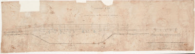
Engineer's drawings of the Teesdale Bridge by CAC Wilson, Image held by the
State Library of Victoria
By the turn of the century however, the decking timbers in the new bridge were deteriorating and in 1901 Wilson, as shire engineer, was calling for funds to have the timber supports replaced by steel girders. I suspect these measures were implemented as the bridge today fits this description.

The Teesdale Bridge in 2013
Wilson was not only an accomplished engineer, but also a revolutionary one. Many of his bridge designs were influenced by his relationship with the Department of Engineering at Melbourne University who at that time were conducting research into the construction and design of wrought-iron bridges. This relationship is reflected in bridges such as the Barwon Bridge mentioned earlier and the wrought-iron girder bridge over the Leigh River at Shelford, built between 1873 and 1874 which I showed in a previous post.
Shelford Bridge designed by CAC Wilson
Not surprisingly, another of Wilson's projects was to design the new shire hall which was opened in 1872 on the Rokewook-Shelford Road - a relatively isolated location, yet one which was central to the major towns of the shire.
Leigh Shire Hall, built 1872
Closer to home again, Wilson was also the engineer responsible for the construction of the Black Gully dam, built between the towns of Inverleigh and Teesdale in 1874 as a potential water supply for both towns. Today, this site can be found near the north east boundary of the Inverleigh Flora and Fauna Reserve where the remains of the dam can still be seen.
A rainy day at Black Gully Dam. This photo was taken from atop the remains
of the earthen wall commissioned by Wilson. Note the stones at bottom
right of the picture
Plans to use this water supply however were short-lived. In 1880 when severe flooding damaged the dam wall, the cost of repair was deemed prohibitive and it was decided to find another water supply. Fortuitously, a couple of years earlier in 1878, a second site closer to Teesdale had been gazetted following some testing by Wilson in the form of sinking wells. This lagoon, which provided Teesdale's water until 1974, became known as Chinaman's Lagoon.
A few kilometres further north, at the border of the Leigh and Meredith Shires was another small bridge which also came in for attention from CAC Wilson during his tenure as shire engineer. This was Taylor's Bridge at Bamganie, so called because it abutted the 1880 land selection of Mr Edwin Taylor. The bridge on Henderson's Road crosses Wilson's Creek just south of its confluence with Woodbourne Creek. Today it is a simple, concrete structure with a graveled surface, barely noticeable as you navigate the twists and turns of the road at this point.
Taylor's Bridge, Bamganie 2013
In February, 1883 however, it was a timber structure which was unable to stand up to the heavy floods which swept down the creeks to the Leigh River below. The bridge was destroyed and assessment by Wilson and his counterpart from the Meredith Shire determined that a replacement was needed. Contracts were called by Leigh Shire and the following year - after some delays - the bridge was rebuilt in similar form to the original and with a timber and stone culvert reinforcing the road near the western end of the bridge. This bridge served the shires for more than twenty years until in 1905 it was declared dangerous and the Meredith Shire resolved to have Wilson effect the necessary repairs. It was not until August the following year however, that Wilson declared the bridge closed for this purpose.
In the late 1880s Wilson designed McMillan's Bridge, a replacement for an earlier timber truss bridge over the Mt Misery Creek (at the time called the Little Woady Yalloak River) on the Rokewood-Skipton Road which had served since 1856. The new bridge was an iron and masonry structure like a number of those described above, employing a pair of 99ft lattice girders in a single span, but reusing the sandstone abutments from the previous structure. The deck was of hardwood topped with road metal. The bridge still stands today on the Rokewood-Skipton Road which at that time, bore the name of the Upper Western Road and ran from the Ballarat-Geelong Road through the towns of Leigh Road (Bannockburn), Teesdale, Shelford and Rokewood, crossing the Leigh Shire to the north of The Lower Western Road which also traversed the shire. Both roads were in large part the responsibility of the Leigh Shire and engineer Wilson.
In addition to these better-known structures, Wilson was also responsible for the maintenance and reconstruction of any number of smaller, lesser-known bridges and crossings such as the stone causeway which crossed the Cressy-Shelford Road in the 19th century, and a tiny bridge in Teesdale which crossed Native Hut Creek on Tolson Street. Wall's Bridge still stands there today and is clearly not new. A review of historical newspapers indicates that a timber bridge existed on the site at least as early as the 1870s, however like all such structures it needed regular maintenance and repair. By 1908 it was in need of replacement. Council voted that is should be replaced with an iron girder structure and in March the following year, tenders were called. In a matter of weeks however, it was decided that none of the tenders were acceptable and Wilson and another councilor were to discuss cheaper alternatives instead. All was quiet on the matter until August, 1910 when Wilson provided the council with three estimates for bridges constructed from timber, stone and iron, or concrete.
Finally, in March 1911, the council decided upon a timber and concrete bridge and the contract was awarded to John Pryor who had started work by July. Looking at the bridge today, it consists of two timber piers topped by iron girders, overlaid with timber and a - very - thin coating of bitumen. At each end is a small concrete abutment.
Bitumen and timber decking on Wall's Bridge, Teesdale
I am no expert, but would guess that the piers and abutments date back to the final years of CAC Wilson's tenure as shire engineer. Whilst the timber decking also looks to be of some age, I can only assume that if the bridge was built to the original specifications, then the iron girders must have been added as part of more recent repairs, with the timber either reused or replaced as necessary.
Wall's Bridge, Teesdale
And so it went on, year after year, decade after decade, bridges, roads, dams, buildings; CAC Wilson designed them all. In total, he was responsible for the construction of at least 108 bridges throughout the district, built first in timber then in metal and concrete as he strove to find practical application for the theory developed by Melbourne University and provide cheaper, more durable alternatives for shire infrastructure.
He finally retired as the engineer of the Leigh Shire in 1910 when he was replaced in this role by his eldest son Charles Corbett Powell Wilson. His tenure as shire secretary however, continued for several more years, ending with his retirement in 1917 - a total of 54 years service to the shire.
Wilson died in Geelong on 7th October, 1923, survived by ten of his children and is buried in the Portarlington Cemetery.

29 March, 2015

Branching out - Chinaman's Lagoon

The little town of Teesdale is situated on Native Hut Creek - a tributary of the Barwon - and was mentioned in one of my previous posts. The history of the area dates back 40,000 years to a time when the progenitors of the Wathaurong clan lived along the creek, harvesting root vegetables and catching fish from the creek.
In 1837, things changed forever when European settlement in the form of Thomas and Somerville Learmonth arrived in the district. Under the auspices of the Derwent company, they established three squatting runs along Native Hut Creek, each named for the creek and numbered 1, 2 and 3 respectively. Rough maps showing modern roads overlaid with the extent of the various squatting runs indicate that what became the town of Teesdale was located on Native Hut Creek No. 2 run which later became known as the Woolbrook Estate.

The gate to Woolbrook today
The Learmonths did not remain long in the district and the estate soon passed to Joseph Tolson. He was followed by Francis Ormond in 1848, Jeremiah Ware in that same year and then only a few years later in 1851, Peter Sharp took up the lease and the following year applied for the pre-emptive right to 640 acres of the property, paying 20 shillings per acre.
By 1854, the property was in the hands of a consortium of three squatters but by 1856 John Bell was the sole owner of the freehold. The following year, he built a three-roomed bluestone house on the property for his brother James, who lived there with his family until 1900.
Woolbrook homestead, early 1900s. Photo held by the State Library of Victoria
As the squatters opened up the land in the district to grazing, other settlers followed in their wake and townships began to spring up. One such on the Native Hut Creek No. 2 run was surveyed in September, 1851 and given the name Teesdale.
Of course, one of the primary concerns for any new establishment is a water supply and Teesdale was no different in this respect. Initially settlers took water directly from the creek which is fed by a series of natural springs. Water was also taken from a small lagoon just to the west of what is now Turtle Bend. Today, this is a small dam which is currently empty, however at that time, it was more extensive than today, extending across where the road now runs and towards Turtle Bend. It was also fed by an underground spring.
The currently dry lagoon near Turtle Bend
 
In those early days, a pump and a standpipe were placed at the lagoon to provide water for the residents and the local women would do their weekly washing in the freshwater springs nearby. During dry periods however the water would become brackish and eventually, by the 1870s salinity was a permanent problem. A new water supply was required.
Initially, it was envisaged that Teesdale would take its water from a dam built at Black Gully in 1874, located between Teesdale and Inverleigh and would share supply with that town. (It should be noted that the shire engineer for that project was one C.A.C. Wilson of Leigh Grand Junction Bridge fame.) However, significant flooding in 1880 - the largest recorded in the state at that time - damaged the dam wall and it was deemed too expensive to repair. In the meantime, a second dam was being built at Todd's Gully, closer to town. The land had been reserved for the purpose of supplying water in June, 1878 and construction was soon underway.

Building Chinaman's Lagoon c1878-1879. Image held by the State Library of Victoria
However, whilst the land was suitable, the site of the dam was somewhat removed from the township and access was via a council road which had been fenced in by a settler (Alex Munro) as part of his selection. In the end, it was decided that the easiest solution was to lay a pipe from the dam to the Mechanic's Institute in town where a standpipe would provide water to the town's population as well as servicing passing travellers - many of whom were headed to the Ballarat Goldfields.
Chinaman's Lagoon today
In February, 1883, three contracts were entered into. A quote of £99 was accepted from one Quin Yung for 7.5 chains (approximately 150m) of tunnel, a second for £79.10.0 from D. Munro for digging trenches and laying 32 chains (approximately 640m) of pipe and the final was for John Danks to supply 2112 feet (about 640m) of galvanised iron pipe at a cost of £96.15.0. The work was completed in a matter of weeks and by April, 1883 water from the dam was flowing through the newly-installed pipe to the town.
That same month, it was moved at a council meeting that a trough should be installed at the standpipe, however I am unsure whether this plan came to pass.
Original well built by Quin Yung beside Chinaman's Lagoon

Whilst the names of the contractors may have been forgotten over the years, the fact that one was Chinese was not and today the dam is known as Chinaman's Lagoon. Whilst no longer providing Teesdale's water, the lagoon still provides a habitat for native flora and fauna and is accessible to the public via walking tracks in the area.
The dam did however continue to served the population of Teesdale until 1974. At this time, the She Oaks Diversion Weir and the Moorabool Water Treatment Plant were completed - as described in my post Branching out - a diverting lesson, bringing to fruition a project begun two years earlier in 1972, with the completion of the Bungal Dam on the Moorabool River at Lal Lal. During construction of the dam, the Bannockburn and District Waterworks Trust contributed financially to its building and as a result was entitled to a  91Ml share of water annually for the towns of Bannockburn, Inverleigh, Shelford, Teesdale, Lethbridge and Meredith. It is this allocation of water which today flows via the She Oaks Diversion Weir before being piped to Teesdale and the other towns mentioned, providing mains water for the community.
More details of Teesdale's water supply across the years can be found in Dianne Hughes' 2011 publication "From Native Creek to Teesdale: 1837-1900" (ISBN: 9780980715989) as well as "Living By Water: a history of Barwon Water and its predecessors" (Leigh Edmonds, 2005; ISBN: 0959491953).