Showing posts with label Ballarat. Show all posts

17 May, 2016

Songlines of the Barwon Catchment

During the recent Mountain to Mouth 2016 extreme arts walk held across the City of Greater Geelong and the Borough of Queenscliffe, one of the catchphrases used was "walk this land". Participants were encouraged to consider those who have walked the land before us. Part of our route took us along the Barwon River, with the event ultimately concluding on the banks of the river at Barwon Heads.
With this in mind, I thought I would have a look at the lands of the wider Barwon catchment and the people who have walked them. The way we cross the land today is perhaps best represented by maps. For thousands of years before the arrival of Europeans however, the indigenous tribes of Australia walked the land, following ancient tracks and pathways known to their ancestors, without the benefit of modern cartographic techniques.
For 25,000 years prior to the arrival of Europeans, the Barwon catchment was home to three indigenous tribes. The lands surrounding the lower Barwon - downriver from Winchelsea - as well as the catchments of the Moorabool and Leigh/Yarrowee Rivers were occupied by the Wathaurong (Wadawurrung) people. The lands of the Gulidjan Tribe lay along the upper reaches of the Barwon, also incorporating the area around Lake Colac. The Barwon itself formed the boundary between the Gulidjan people and their southern neighbours - the Gadubanud Tribe - who lived on the land between the river and the coast, stretching westwards past Cape Otway.
Adaption of the map "Catchments of the Barwon River and inland Basins", created
by the Victorian State Rivers and Water Supply Commission, 1950 (original
image held by the State Library of Victoria). Clan territories estimated from
Clark, 1995, "Scars in the Landscape"
Rather than physical maps such as the one above, indigenous maps were shared through dance, song, painting and story. They talked about the features of the land itself; the rivers and creeks which showed them the way from one place to another, the hills, the trees, the rocks, the waterholes passed along the way. Even the sky played a role. Following these "songlines", it was possible to walk for hundreds of kilometres. In this way, people could move between tribes, establish trade routes, make marriages, manage natural resources; walking - it was believed - in the footsteps of the creator spirit.
And it isn't too much of a stretch to see how songlines could work. The name of the Barwon itself is a directional description. Barre Warre N Yallock - the big river which flows from the mountains to the sea. Follow this river and you will reach the sea. Kooly bar ghurk (Coolebarghurk): man's track by the creek. Another descriptive name. Which track? The one by the creek. The one made by people, not the many animal tracks which no doubt criss-crossed the land.
"Man's track by the creek". For thousands of years, the Wathaurong walked the
banks of Coolebarghurk Creek
Wormbete: which lake? The "lake with the black fellow's mound". Where? Bukar Bulac; the place between two rivers. This was the Wathaurong name for the confluence of the Moorabool and Barwon Rivers.
Creation stories told how the eagle Bundjil looked down upon the world from the sky where his fire (the planet Jupiter) could be seen from Earth. Bundjil it was said, made his earthly home at Woringganninyoke - Lal Lal Falls. Whilst the meaning of the first name is unknown, "Lal Lal" is said to mean "dashing water in a crevice". Another literal description which could contribute to a songline.
Lal Lal Falls, April, 2012
Many other sites were named for prominent features which could also be used as part of a songline. Someone wanting to journey north west from Jillong (Geelong), the "place of native companions" or the place "where the seabirds fly over white cliffs", could perhaps travel to Durdidwarrah where either a "shelter of bark" or "dead water" could be found after which they would reach Bungeeltap (meaning either "spirit water" or "eagle's nest"). From there, they could see [Mount] Warrengeep (Warrenheip) where the ferns of the side of the mount resembled "emu feathers" before passing Bonan Yowing (Buninyong), the mountain shaped like a "man lying on his back with his knee raised." Once there, it wasn't too far to Balla arat (Ballarat), the "reclining on the elbow" "place" or resting place.
Bonan Yowing: Mt Buninyong, visible across the surrounding countryside
for many kilometres
Like today's Google Maps, the songlines of the indigenous peoples not only described which route to follow, but gave tips about where to stay and what food could be found along the journey: Yarram Mordong (the Wathaurong name for Buckley Falls), waterfall [of] eels; Porrong Goop (Borrongoop), the place of quails; Koo N Warre (Lake Connewarre), mud oyster water.
Koo N Warre: Lake Connewarre
In this way, the Wathaurong, Gulidjan and Gadubanud Tribes of the Barwon catchment "mapped" out the land, preserving their knowledge over thousands of years for future generations. Until European settlers arrived...

22 April, 2016

Making tracks: lies and deception

So, how did the diggers decide which road to take when heading from Geelong (or Melbourne via Geelong) to the goldfields of Ballarat and beyond?'
Word of mouth was certainly important. Anyone recently returned from the diggings with news of the latest rush was questioned closely. Newspapers were scanned in minute detail to glean any information about which field had the greatest returns and what was the best route to get there. Weather reports were no doubt also taken into account when considering which road to take and the means of travel could also affect choice of route. For those wealthy enough to afford it, travelling by coach determined which road was used, but for those on foot - as many were - the shortest route may have held the most appeal. For the array of horses, carts, drays and wagons however, it was not so easy to skirt around a bad section of track - as described by Henry Mundy in his account of his time spent on the goldfields - so the shortest route may not always have been the quickest. Misjudging a creek-crossing or becoming mired in a swamp could be a very costly and even dangerous occurrence.
One source of information which purported to help the would be diggers avoid the traps and pitfalls of their newly-chosen career was guidebooks. The Digger's Hand-book, the Gold Digger's Guide, the Gold Seeker's Guide and a plethora of other helpful publications were guaranteed to provide all the information an aspiring digger needed; a list of what clothes and equipment to take, what rations to carry and what could be found along the way. Most importantly perhaps, the digger's guides also included maps, a description of the route, details of what conditions to expect during the journey and potentially also a list of places to stay or camp and the distances involved.
An example of a gold digger's guide, image from the National Maritime Collection
Whilst I found a number of newspaper articles providing helpful information for diggers and an array of advertisements selling everything from tonics to miner's cradles, diggers guides were not so easy to come by, with the exception of the one pictured above, the text of which can be found here.
Sources of information such as these whilst useful, were not however to be entirely trusted. Newspapers then as now had their own agendas which often reflected the interests of the towns and people they represented. With the outbreak of the gold rush in 1851, many of those towns were keen to profit from the flurry of activity it generated. Of course, those who were situated closest to the goldfields stood to benefit most and it wasn't long before a slanging match developed between Geelong and Melbourne with The Argus and the Geelong Advertiser championing the causes of their respective towns.
Not surprisingly, one of the chief topics of interest was the proximity - or lack there of - of each town to the Ballarat goldfields. Within weeks of the discovery of gold in Victoria, claims, counter claims, allegations and insinuations were flying. Also up for debate was the estimated cost of buying equipment for the goldfields from either town and the state of the respective roads between each and the diggings.
Nor was the battle confined to the pages of the local newspapers. In 1854 a map was published which purported to show the "true" distances between Melbourne, Geelong and the various goldfields but which placed Geelong at twice the distance from Ballarat as it did Melbourne. Not surprisingly, there was outrage amongst the Geelong fraternity at such a fraud being perpetuated upon their town.
The "false" map of the goldfields (Turnbull, 1989)
Whilst no-one seems to know who put the map together, the lithographers who printed it were Messrs Campbell & Fergusson of Melbourne. The map was recently on display at the Geelong Regional Library, but has also been reproduced in various places including "Maps are Territories: Science is an Atlas" (David Turnbull, 1989).
Whilst this map is a blatant example of the intercity rivalry, other maps were more accurate but could still prove misleading. At the outbreak of the gold rush, there were a number of maps which were considered reliable such as government surveyor A.J. Skene's 1845 "Map of the district of Geelong", engraved by Thomas Ham of Melbourne and published by James Harrison of the Geelong Advertiser.
The relevant portion of Skene's 1845 map of  the Geelong region, showing the main tracks between
towns at that time. Image held by the National Library of Australia
Another map which could be trusted to give a reasonably accurate representation of the district was Thomas Ham's 1849 "Map of the purchased and measured lands, counties, parishes, etc. of the Melbourne and Geelong districts", published prior to the discovery of gold.
A portion of Ham's 1849 map of the Melbourne and Geelong regions.
Image held by the National Library of Australia
It is worth noting however, that a subsequent map produced in 1852 by Ham (after the discovery of gold), whilst accurate, took the approach of displaying only the area north of about the 38th parallel south, which passes not too far below Werribee. This way, Geelong is not shown, and on the copy held by the National Library of Australia the roads to Buninyong and Ballarat from Melbourne have been highlighted (after publication) whereas those to Geelong were untouched or marked only faintly. Whether this was an intentional ploy to disadvantage Geelong or merely the result of a "Melbourne-centric" view of the gold rush is not clear.
Ham's 1852 map of the routes to the Mt. Alexander & Ballarat gold diggings.
Image held by the National Library of Australia
Despite both early maps being relatively accurate however, there were slight variations between Ham's 1849 and Skene's 1845 maps. Skene for example more accurately locates William Cross Yuille's Ballarat Run to the north of Mt Buninyong, whilst Ham shows it to the north west below Lake Burrumbeet. Despite these discrepancies, both the 1845 and 1849 maps give a reasonable representation of the main features of the landscape, but only give a general idea of the main tracks. This would be due at least in part to the fact that not all land in the area had been accurately surveyed at that time.
Other less official maps also claimed to provide accurate information, but were similarly vague. The "Notes of a Gold Digger and Gold Digger's Guide" shown above, contained a map "compiled & engraved by Samuel Clavert" dated 1852. Whilst the distances shown are reasonably accurate, once again, the track is a general line with few landmarks to use as a guide. Whilst Geelong is shown on this map, distances are marked from Melbourne to each of the goldfields listed but no distance is given for the road from Geelong to Ballarat, nor is the Geelong-Melbourne Rd marked on the map.
Map of the goldfields from "Notes of a Gold Digger and Gold
Digger's Guide" 
1852.
A fourth map from 1853 gave a little more detail as to places, showing inns and stopping points along the way - no doubt reflecting the many establishments which were popping up along the various routes to the goldfields to cater to the passing trade. Despite this, the map still showed only an approximation of the tracks involved and in this instance appears to show the distance from Geelong to Buninyong via Shelford to be the same as that via the Geelong-Buninyong Track. It was, it claimed "carefully compiled from authentic sources & lithographed by Edwd. Gilks."
The digger's road guide, to the gold mines of Victoria and the country extending
210 miles, round Melbourne. Image held by the National Library of Australia
So, all things considered,with an array of maps (some conflicting), a steady flow of newspaper reports and returning diggers, each with his or her own tales to tell, variable weather conditions, bad roads, new goldfields popping up here, there and everywhere, not to mention the ever-present risk of bushrangers as well as intense competition for business at every inn or hamlet along the way, is it any wonder that so many towns claimed to be "on the main route [from Geelong] to the goldfields"?

20 April, 2016

Making tracks: decisions! Decisions!

Over the past six months and 21 blog posts, I've followed in the tracks of the gold diggers making their way from Geelong to Ballarat, looking at how they travelled, where they travelled, who they might have met along the way and what conditions they faced. The aim was to decide which - if any - of the various tracks was the "main" route to the goldfields - a claim made of each of these tracks at one time or another.
Google Earth image showing the likely routes via Shelford (red),
the Geelong-Buninyong Track (green) and Steiglitz (blue)
Teesdale it is claimed at a local park lay on the "main gold route". The Eclipse Inn north of Steiglitz was situated on the "best line of road" to the goldfields, boasted a real estate agent in 1853. A report by the Victorian Heritage Database states that "later the Warrenheip Road to Ballarat became the main gold fields route from Geelong", whilst in 1943 a local resident of the town of Meredith recounted that "when gold was first discovered at nearby Buninyong, Ballarat, Steiglitz and Bendigo, most of the traffic to those places started from Geelong and came through Meredith by bullock teams along bush tracks."
Even Skene St in the Geelong suburb of Newtown was claimed as part of "the main route to the Ballarat goldfields" - presumably a reflection of the flow of traffic west towards Fyansford and across the Moorabool River to the Geelong-Buninyong Track near the future site of Gheringhap.
The one thing which does seem clear is that each claim had its own angle: the best road, the main route, the most traffic, a particular point in time. What is clear however, is that over the years, huge amounts of traffic flowed along all routes to the goldfields of Ballarat. But were all the routes equivalent?
Store drays camped on road to Ballarat, TS Gill, 1855, Image held by the
National Library of Australia
Well, the distance of each was not the same. The journey from Geelong to Ballarat via the Geelong-Buninyong Track and the Plank Rd was around 50 miles (80km). From Geelong via Steiglitz and Warrenheip to Ballarat was about 59 miles (95km) whilst the track via the Leigh Rd to Shelford and then to Buninyong and along the Plank Rd was also around 59 miles. If travelling via Magpie Gully instead of the Plank Rd, then an extra mile or more could be added to the journey.
A difference of 9 miles or 15km is not so much on modern roads with fast cars, but to a digger walking the distance, this could amount to almost half a day's extra walking. If however, a dray were to become mired in Scott's Swamp, not only hours, but days could be lost, not to mention the potential for broken wheels and axles, the loss of an expensive horse or bullock or even the significant physical exertion required to unload and reload an entire dray full of supplies in order to lighten the load and escape the bog. As a result, whilst the shortest route may appeal to those on foot, road conditions may have been more important than distance to those travelling by vehicle.
To complicate the issue further, there were any number of alternate routes and tracks connecting each of the three roads running north-south. From the Steiglitz road it was possible to cross the Moorabool River and reach the Geelong-Buninyong Track via the Melbourne-Buninyong Rd intersecting at Green Tent, Sharp's Crossing which intersected at the same point, the Steiglitz-Meredith Rd and at least one other unnamed crossing to name a few.
From the west, it was possible to cross the Leigh River at 'Narmbool' and possibly also at an informal crossing near Bamganie. Today, a number of small fords cross the Leigh on private property, presumably it was no different in the 1850s. In a time when a bad track or tricky creek-crossing saw travellers take to the bush, forging their own path, it is not surprising that informal tracks and crossings proliferated.
Google Earth image showing the interconnecting tracks between Geelong and Ballarat. Red
lines show tracks marked on survey maps, blue lines show approximate routes described, yellow
lines show likely connections along and between routes using modern roads, green lines
show estimated routes based on surveyor's field books. Early inns along the routes are also shown.
Click to enlarge
Another important factor was date. When the gold rush first broke out in August, 1851 everyone wanted to be at Hiscock's Gully. Two weeks later, after the discovery of Golden Point, they were also flooding to Ballarat along the Geelong to Buninyong Track. The surface alluvial deposits however, were quickly worked out and within a short time, deep lead mining became common. As the miners followed these leads, mining activities spread out across the Sebastopol Plateau following the course of an ancient river underlying the Leigh. It makes sense that anyone travelling to these mines during the 1860s would consider travelling via Shelford.
At Steiglitz, the discovery of quartz reefs in 1855,  drew traffic from Geelong and also from Ballarat, presumably making the route from Geelong to Ballarat via Steiglitz and Warrenheip more appealing at that time. This road also provided access to other nearby goldfields such as Mt Egerton, Dolly's Creek and Gordon to name a handful.
Despite all of this however, it is worth remembering that coaches - including Cobb & Co.'s famous Leviathan Coach capable of carrying 89 passengers - continued to run directly between Geelong and Ballarat along what soon became the Geelong-Buninyong Rd. After the discoveries at Steiglitz, extra services ran via Hope's Bridge over Sutherland's Creek to the town, however coaches from Steiglitz for Ballarat still travelled via Meredith, Buninyong and Magpie Gully, rather than the Eclipse Inn and Warrenheip. A comparison of distance shows the coach route to be only a mile or so shorter than travelling via Warrenheip. I cannot see any mention of a coach service via Mt Mercer throughout the gold rush period, however the Portland Bay service from Geelong did pass through Shelford, Cressy and Fiery Creek further to the west.
Cobb & Co.'s Leviathan Coach, c1862. Image held by the Victorian State Library
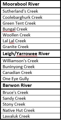
Regardless of which route the diggers chose, one thing was certain: at some point they would have to cross, walk alongside or take water from the the tributaries of the Barwon River. Whichever route they chose would require not just one, but numerous creek and river crossings. Whether at Batesford, Fyansford or east of Buninyong, the Moorabool River had to be crossed. Travelling via Shelford also meant crossing the Leigh/Yarrowee River at least twice, if not three times, not to mention the many creeks and gullies along the way. Below is a list of the main creeks along the three routes, grouped according to the river into which they flow.
In the early days before bridges were built, fording creeks and rivers was inevitable and bad weather could have a significant impact, not only on the road surface, but also on the ease with which a creek or river could be crossed - if it could be crossed at all. Newspaper reports of flooding often also came with reports of drownings, both of animals and humans as attempts were made to cross dangerously swollen creeks and rivers. Another reason for diggers to consider carefully which route to take.
There is one other factor which could also influence the decision and which could significantly alter the flow of traffic along a particular road: maps.
And some of those maps will be the topic of my next post.

24 February, 2016

Making tracks: One Eye Gully

Gold seekers from all over the world flocked to Ballarat after the August, 1851 discoveries of John Dunlop and James Regan at Poverty Point and as the numbers of diggers increased, the township of Ballarat was established. Initially, the Ballarat diggings were a rough collection of huts and canvas tents spread out along the creeks and gullies of the Yarrowee River, but as more and more people arrived - not just single men roughing it, but whole families including women and children - the tents gave way to timber buildings and then as mining practices moved on from shallow alluvial workings to more established deep lead mining, permanent, brick buildings were erected.
The early township grew up in a haphazard fashion around the sites where the miners pitched their tents and along the routes of the original bullock tracks. As a result, the Ballarat CBD as it exists today, was not the centre of town during the early years of the gold rush. Instead, East Ballarat near Golden Point and the Eureka Lead became the focus of activity. Businesses lined the old tracks which became the first roads.
The North Grant Hotel (1859), located on the south east corner of Peel and
Main Street (now Bridge Street), built mid-1850s. Image held by the State
Library of Victoria
The diggers arriving from Melbourne followed tracks which in time became Humffray St, Victoria St and Eureka St. Those who had taken the Burnbank Track from Buninyong past Yuille's homestead, found themselves on a track beside the Yarrowee River which led to what eventually became Grant Street, but probably it was more common for those making the last leg of the journey from Buninyong to follow a shorter track described by the historian WB Withers in 1888. The track he indicated was "on the eastern side of the creek that ran down past the Main Road Gullies to the Yarrowee".
He was of course, referring to the track which eventually became the Geelong Road out of Buninyong and which upon its arrival in Ballarat becomes Main Road. The early survey maps of Buninyong Parish clearly mark the southern portion of the old track which branched off from the Geelong to Buninyong Track near the current intersection of the Midland Highway and Lal Lal Street. From that point, the track to Ballarat skirted the township of Buninyong, followed a north westerly line to the outskirts of present-day town, then turned more northerly and passed between Mt Helen and another small peak to the east which at that time was known as Green Hill. Traces of Green Hill can still be found in the names of local roads.
It is near this point, close to Gear Ave and Federation University where Canadian Creek rises as a series of springs, flowing north to its confluence with the Yarrowee River near Golden Point. The track taken by those early diggers roughly followed the course of the creek, tracing a path down the gully to Ballarat. At that time, the upper reaches of the creek were known as One Eye Gully. It was not until later that the creek took on its present name which is attributed to an early digger by the name of Canadian Swift, one of a group of lucky diggers who discovered the sizeable "Canadian Wonder" nugget in 1853.
Canadian Creek and its tributaries (Specimen, Warrenheip and Pennyweight Gullies) were all the focus of gold mining activities during the gold rush and today still suffer erosion problems as a consequence, adding no doubt to the sediment load of the Yarrowee/Leigh River which in turn deposits its sediment into the Barwon. This however was of little concern to the diggers who arrived in their thousands during the 1850s, traipsing along the track from Buninyong.
The remains of gold workings in a gully which runs into Canadian Creek to the
north of Federation University
At present, I have not managed to find a map which shows the entire path of the track from Buninyong to Ballarat, so I am not sure of its exact course past Mt Helen, other than to say it continued on through Mt Clear to Golden Point where it became what in the early 1850s, was known as Main Street. A contemporary report from the gold rush era mentions that the track was "6 kangaroo miles" from the gully at the base of Green Hill to Ballarat (Geelong Advertiser, 25th August, 1852).
It was not long before the track became a surveyed road and such was the flow of traffic that by 1856 there were calls for tenders to build a plank road along this route from Buninyong to Ballarat. The work was completed by August, 1857 on what only two months later was referred to as the "main high road" to Ballarat. Survey maps along Main Street from 1857 also refer to the Plank Road which continued in use until 1868.
Looking along Main St aka Plank Road in 1859, although there is no sign
of the planks. Image held by the National Library of Australia
It was only a matter of months after completion however, before repairs to some of the planks were needed. A contributor to the Geelong Advertiser of 1st December, 1857 stated that it would be better to travel along the old bush road than to use the Plank Road in its current condition. From this reference it would seem whilst the new road followed a similar path, it was not identical to the original track, which presumably still existed simultaneously with the new road for some time at least. As far as I can tell, the "new road" which eventually became the plank road was still only a "proposal" in 1853.
In keeping with this, Surveyor William Urquhart's 1852 map shows shows a myriad of faint tracks criss-crossing the area between Golden Point and Bakery Hill, but none closely following the present line of Main Road, suggesting it was not surveyed until after that date. Neither however does he indicate the course of the track from Buninyong, although buildings are said to have existed along Main St as early as 1852 when Urquhart was surveying the area. These would have followed the course of the original track and presumably therefore determined, in part at least, the course of Main Street when surveyed.
Interestingly, several geological survey maps show Canadian Creek following and crossing Main St several times between present day Barkly and Esmond Streets, suggesting perhaps that this several hundred metre section of Main Street may have closely followed the original track. Today of course, the re-aligned Canadian Creek flows via a channel somewhat to the west and does not cross Main Road until the latter passes Clayton Street. Main Road however, has not moved since those surveys of the late 1850s.
The lower, channelled reaches of Canadian Creek flowing towards the Yarrowee
River near Poverty Point

13 February, 2016

Making tracks: to Golden Point

On about 21st August, 1851 gold diggers John Dunlop and James Regan, unhappy with the meagre finds and large numbers of people flocking to Hiscock's Gully, decided to try their luck further afield. It was about 6 or 7 miles distant, at what is now known as Poverty Point that the pair struck gold. Thanks to Geelong Advertiser reporter Alfred Clarke, news of their find was soon public knowledge.
At the time of the discovery, Clarke was making regular reports from Hiscock's diggings. On 25th August, he stated that parties were out searching and that gold had been found on Yuille's run towards Warrenheip as well as several finds in the gullies nearby Hiscock's.
Monument marking the approximate location of Dunlop and Regan's gold
discovery at Poverty Point, on the bank of Canadian Creek near Clayton St,
Golden Pont
Gold it seemed, was everywhere. Within a day or two of Dunlop and Regan's find, two other groups of prospectors struck gold less than a mile to the north west, on the opposite side of the point to which Dunlop and Regan were working. This site was given the name Golden Point and in those early days of alluvial gold finds, was considered to be the site of the "main diggings".
Naturally, all parties involved were keen to keep their discoveries quiet, making it difficult to determine who was where first and when, as discovered by a commission set up to establish who - if anyone - was entitled to claim the government reward offered for the first to find gold in the region. The credit for the first discovery and the reward went eventually to Thomas Hiscock for his find near Buninyong, which it was claimed, was part of the same goldfield as the later finds at Ballarat.
If the prospective diggers rushed to Hiscock's Gully, they positively stampeded to Golden Point. By early September, the Geelong Advertiser claimed, there were over 100 prospectors at Ballarat. Within a year of the Poverty Point discovery, there were 20,000 diggers on the field.
An engraving of the Golden Point diggings as depicted by D Tulloch in 1851-
1852. Image held by the National Library of Australia
As news spread, diggers came from all over the country. They followed the bullock tracks from Melbourne, from Geelong and from South Australia via Portland Bay, travelling any way they could. Many of these paths which converged on the diggings can still be seen in the irregular lines followed by a number of the roads in East Ballarat and surrounds today.
Roads such as Humffray St, Main Rd and Eureka St were originally bullock tracks. Humffray St was the main track from Melbourne, running along the southern bank of the Yarrowee River, Main Rd (more of which in a future post) brought diggers from Buninyong up the east side of the Buninyong Ranges and of course, the track which crossed Winter's Flat, past the Yuille's homestead and skirted around the edge of Yuille's Swamp.
Interestingly, a map produced in 1852 from a survey conducted by government surveyor William Urquhart shows two tracks along the Yarrowee from Yuille's station; one along the east bank of the river and the other along the high ground to the west, roughly following the alignment of Armstrong St. The tracks converged on the east side of the river at a point near the present intersection of Cameron and Grant Streets before following a curving path to the north of the modern alignment of Grant Street.
A section of Urquhart's 1852 survey map overlaid on Google Earth. Blue lines
show the tracks from Yuille's and Burnbank, red lines show the present course of
Main Rd and Eureka St. Yellow shows the main diggings at Golden Point as
indicated on Urquhart's map. Green includes Poverty Point. Image held
by the State Library of Victoria  
The original line of the bullock track can be seen in the sketch below from 1856, with the steep banks of the Yarrowee also visible at the bottom of the picture. Even with five years of occupation by the diggers, there appears to be little in the way of permanent buildings in the vicinity. Writing in July, 1888 for the Ballarat Star, historian WB Withers noted that the first brick building in Ballarat East was not erected until 1857-8 at the corner of Main Rd and Humffray St. He also described the diggings as enclosed by the green line on the map above.
A depiction of Grant Street, Ballarat in 1856, looking east from Lydiard St.
Image held by the State Library of Victoria (click to enlarge)
Today, Grant Street is unrecognisable as the bullock track it once was. During the 1860s and subsequent decades, the Yarrowee River through Ballarat along with surrounding creeks were progressively formed and lined with bluestone and brick to control flooding and erosion, changing the landscape further. The end result was a series of channels more akin to storm water drains than a recognisable river system.
Looking east along Grant Street July, 2012 at the Yarrowee River bridge
The section of the Yarrowee in the image below forms the western boundary of the diggings as described by Withers and shown in green on the map above. In 1852 when Urquhart conducted his survey, he described the area as a rich, grassy plain.
Yarrowee River looking north east from Grant Street, April 2012. Canadian Creek
can just be seen in the distance entering the channel from the right. Image
courtesy of C Stevenson
 By the time the diggers had effectively torn the area to pieces in their frantic search for gold, the scene looked vastly different. The once grassy flats were dotted with tents and temporary timber buildings, the ground was riddled with shafts dug by the miners and everywhere were pools of sludge, created by the miners as they washed the dirt to extract every last ounce of gold they could find.
Golden Point in 1857-8. Image held by the State Library of Victoria

23 October, 2015

Making tracks - to the Green Tent

My previous post traced the early stages of the likely route taken by many of the earliest gold diggers as they followed the rush to Buninyong and Ballarat. After leaving Geelong and crossing the Moorabool River at Batesford, they followed the route used first by the bullock drays and then by the mail coaches, branching off the Leigh Road and heading to the Muddy Water Holes as the area around Lethbridge was then called.
This illustration by Charles Lyall, 1854 of a bullock team crossing a river gives
an idea of what the early tracks, such as that from Geelong to Buninyong
were like. Image held by the State Library of Victoria
There was little if anything to be found there at that time, in fact the 1851 description cited in my last post does not mention either Muddy Waterholes or Lethbridge at all, instead, it refers to "the old camping ground known in bushmen's circles as the Green Tent". It is at this point that my research became rather complicated.
The Green Tent is an intriguing but elusive place - notorious even - and is definitely deserving of a post or two of its own.
The exact placement of Green Tent is somewhat unclear and I can find no reference to the original "green tent" which no doubt gave the little settlement and the nearby creek  their name. (Green Tent Creek is a short waterway which flows under the Midland Highway before joining Coolebarghurk Creek just over 2.5 km from where the latter meets the Moorabool River.) The earliest indirect reference I can find is an article from the Geelong Advertiser of 1862 which indicated that there had been ruins at the location for some 18 years, dating the Green Tent back to at least 1844 - a time when the settlement of the Port Phillip District was less than ten years advanced and the floods of gold diggers were still some seven years off.
The earliest contemporary reference I found to the Green Tent was the 1851 description mentioned above, which also claimed it as a well established site even at that date. So, where exactly was the Green Tent, what was it and why was it there?
I am not the first to ask these questions. In 2010 an archaeological dig was conducted which revealed the footings of a substantial building of unknown purpose. A local landowner and historian also has a keen and ongoing interest in the topic. So, what did I find?
Archaeological dig at Green Tent site. Image taken from
 Dr Vincent Clark& Associates website
My approach to the issue (as it usually is) was to head for the electronically available historic records to see what I could locate and to see how this tallied with what others had reported. Initially, I combed the newspapers of the 19th century (accessed via the National Library of Australia's Trove website) for any mentions of the Green Tent - and there were plenty.
Prior to the gold rush, the Green Tent seems to have been little more than a watering hole for passing bullockies, but by 1854 - three years into the gold rush - it was cited as the location of one of a number of unlicensed premises or sly-grog shanties (often euphemistically described as "coffee tents") between Geelong and Ballarat. In 1856 Benjamin Annas was fined £30 for "vending three glasses of brandy" at the Green Tent without a license.
Illustration by S.T. Gill showing a coffee tent and timber huts on Bendigo
Creek 1852, not the Green Tent, but indicative of the era. Image held by the
National Library of Australia
In 1858 however, the name "Green Tent" took on a notorious connotation. On 10th July that year, Elizabeth Lowe was brutally murdered in front of her two infant children. Her attacker - Owen McQueeny - was soon arrested and after a short trial, was hung for his crime. Several interesting pieces of information about the Green Tent arose from the inquest and subsequent trial. The evidence of various witnesses and contemporary newspaper reports, built a picture of a single mother struggling to support an 18 month old toddler and a second baby only a few weeks old. Abandoned by her husband, she had built herself a "tent" constructed partly of weatherboard and with a canvas roof and back section, petitioned to separate off a sleeping area.
Elizabeth kept a few bottles of grog a slab of cheese and bread which she would serve to her customers - said to be men working on the roads nearby. By implication, other "services" were also supplied and it is believed that McQueeny was a customer who had been hanging around her tent. She informed at least one neighbour that he was beginning to frighten her. Not surprisingly, his version of events read somewhat differently as this article from The Age shows.
Whilst they make gruesome reading, the newspaper reports of the events surrounding Elizabeth's death give more detail about the settlement at Green Tent. Firstly, Elizabeth was not living entirely alone. It was noted in evidence that other tents in the area had been robbed by McQueeny not long before Elizabeth's murder and Mary Campion (possibly Mary Sampson) indicated that she had, until shortly before the murder, lived within 100 yards of Elizabeth's tent but now lived a little less than a mile away. On the morning of the murder, she and her husband heard a gunshot in the darkness at around 6 am.
In one of its early reports, the Age insisted that Elizabeth did not live near the Green Tent, but that her dwelling was in fact the Green Tent which had been variously occupied for at least five years, during which time it had developed a bad reputation. It may be worth noting at this point, that she had probably been living there for about four months since her husband had left. I also found reference to a William Dawson, a store keeper of Green Tent who was declared insolvent around the same time in March, 1858. I have no evidence, but suspect she may have moved in and occupied an existing empty building (if it could be called that), making her own additions to keep out the elements.
 Also living in the vicinity was Mr Thomas Champion, the proprietor of an eating house/store. It was to Champion's that Elizabeth's body was taken for the inquest, after which she was buried on the bank of a nearby creek. In another macabre twist, her body was exhumed a fortnight later to provide more evidence for the trial of her murderer. Some sources indicate that Elizabeth's body was reburied at the Old Meredith Cemetery, however an article published in 1922 which describes the return of Elizabeth's son to the scene of his mother's murder, indicates that she remained buried in the original location and that until a short time before his return, the grave had been surrounded by a picket fence.
So, where was Elizabeth's tent and where were the others in the area living? In one of those curious coincidences, government surveyor Maurice Weston was working in the vicinity of Green Tent, and the day prior to the murder, was only about a mile away. By the end of August, he was surveying the land immediately to the east of Elizabeth's tent, the location of which, he marked in his field books (which can be viewed on the Landata website).
Page from the field book of Maurice Weston, 1858
showing the position of Elizabeth Lowe's tent
According to Weston's measurements, in layman's terms, Elizabeth lived 396 yards before the 30 mile post from Ballarat (marked clearly on a later 1867 geological survey map of the region) and 240 yards south west of the main road to Ballarat (see map below). This very exact description is supported by the evidence of a witness at McQueeny's trial - local farmer Thomas Cleary. He described the Green Tent as standing "off the metal road about 200 yards and to the left of the road going to Ballaarat(sic).
Weston indicates at least one section of the main road to Ballarat as being "metal" in his notes, which suggests that it was also informally known as "the metal road".
Some distance away, on the banks of Coolebarghurk Creek, he also noted the presence of a grave.
Page from the field book of Maurice Weston, 1858
showing a grave site. Probably that of Elizabeth Lowe
Unfortunately however, Weston made no note of where others in the area were living. We know from the evidence of the inquest that Elizabeth's tent was some distance away from the other residents - a fact which concerned her. We know Champion's store was in the vicinity and there were others living in tents. By the following year (assuming no move took place) Champion's was referred to as Champion's Hotel.
Looking south east across the site indicated by surveyor Maurice Weston as
the site of Elizabeth Lowe's tent
At this point however, things become a little unclear.
In September, 1859 the Green Tent Hotel was advertised for sale. The description given indicated that the premises were newly-built and extensive but the vendor's name is not mentioned. It could have been Champion's. The following month, Francis M'Kenne, a boardinghouse keeper at the Green Tent was declared insolvent, however there is no mention of the name or location of his business.
By 1860 another player had appeared. William Hooley was running the "Old Green Tent Hotel", a timber structure located not far from the 25 mile post from Geelong. According to the newspapers, Mr Hooley's hotel was situated opposite Champion's. Hooley was not in business for long however as his establishment caught fire and burnt to the ground on 21st March, 1862, leaving only a kitchen and stables which were detached from the main building. His friends and associates rushed to his aid and quickly relocated him to Champion's Hotel "over the road".
Thomas Champion it seems did not remain long either. In April, 1861 he put his hotel - including 10 rooms, a 20-stall stable, stockyards and outbuildings - on the market, then again in May and a third time in August. The property was also described as situated on 2 acres of securely-fenced government land. Interestingly, the early survey maps show a small reserve of about 6 acres, positioned roughly to the south of the Green Tent Creek on the western side of the highway - a likely location for Champion's Hotel.
By October the following year, the hotel was on the market once again. On this occasion however, the proprietor was J.H. Jones and the property was to be auctioned at noon on 29th October, 1862.
The Green Tent is next mentioned in 1866 when John Kneale was described in rate books as keeping a beer house at Green Tent on land owned by Alexander Sutherland. The Sutherland's Native Creek Run was located to the west of the current highway.
Looking north west across Sutherland's pre-emptive right
 Upon the death of his wife Bridget in 1871, Kneale was required to sign probate documents in which he declared that he was "of Green Tent near Meredith in the Colony of Victoria formerly Lodging House Keeper now out of business". By December that same year however, he gave notice of his intention to apply for a publican's license at the Green Tent where he was proprietor of an establishment consisting of ten rooms in addition to those used by the family, a detached kitchen and stabling for 30 horses with a secure supply of water. From the description, this was presumably the one-time Champion's Hotel. Kneale's tenure however was also short-lived and by late 1872 he was looking to sell the property. Still at Green Tent, John died the following year and was buried at Meredith.
The name Green Tent Hotel continues to appear in the newspapers for some years after this time, however, by the 1870s, the huge amount of traffic generated by the gold rush had begun to decline and the Geelong-Ballarat railway which had opened in 1862 bypassed the little settlement of Green Tent, taking potential customers with it.
So, no-one seems to know the exact origin of the original "green tent" but it may have occupied a site in the area as early as 1844, providing a respite for the early settlers as they made their way with their stock to their distant runs. With the arrival of the gold rush, the Green Tent - by then a well-established watering hole - became a stopping point for the diggers as they came and went from the goldfields; a place where they could spend the night or just quench their thirst with a (sometimes not so legal) drink before continuing their long trudge.
The events surrounding the murder of Elizabeth Lowe established the position of at least one Green Tent residence - hers - and it seems that it had been standing for some years and was thought by some to be "the" Green Tent - a sly-grog shop with a bad reputation. At some distance, but still near enough to be considered part of Green Tent, were two public houses, located on opposite sides of the current Midland Highway. Champion's was a substantial building and it may well be the footings of this building which were excavated during the 2010 archaeological dig on the western side of the highway. The other - presumably older - building occupied by William Hooley, was a timber structure which burnt down in March, 1862.
Looking south across the site indicated as "Green Tent" on the 1867
geological survey map and possible site of Hooley's "Old Green Tent Hotel"
At that time, there were also a number of people in the area living in informal tents or huts. Their location is unclear, however the geological survey map of 1867 indicates a small cluster of buildings, labelled as "Green Tent" on the banks of the creek with the same name. The map places the settlement to the east of the Midland Highway, just before a sweeping right hand bend, about 1.3 km past Taylor's Road and only a few hundred metres from the site of the archaeological excavation. On the same map, at a slight distance from the settlement is marked an "inn shed". It occurs to me that by 1867 when the survey for the above map was completed, the outbuildings would be all which remained of Hooley's hotel which had burnt down some four years earlier.
Google Earth image showing my estimations of various locations mentioned above
Whilst more proof is needed, the above map indicates what I think are the likely locations for the events and places described.
Note: a little more research has revealed more circumstantial evidence. An article published in The Argus of  31st August, 1866 indicates that an applicant for some land at Green Tent had 80 acres surveyed which it was said enclosed the only fresh water reservoir for some distance around. The land was indicated as important to the local inhabitants and had previously been a reserve [a government reserve I assume].
Whilst the location of the land is not clear, only a few months later on 27th November, John Matheson of Moranghurk purchased several blocks of land either side of - but excluding - the reserve and a neighbouring block between the railway line and today's Midland Highway.

08 October, 2015

Making tracks - to the goldfields

So following on from my previous post, what route or routes did those first gold diggers take on their journey from Geelong to Buninyong and Ballarat following the discovery of  gold in early August, 1851 at Hiscock's Gully? Within only a few months of the find being announced, thousands of diggers had flocked to Buninyong and nearby Ballarat. They came from all over the world, by any means available and to get there in those early days, they followed the old bullock tracks, forged by the squatters and the early settlers of the district.
Immigrants arriving by ship had two choices. Those who arrived in Adelaide faced a lengthy overland trek. The alternative was to disembark at the port of Melbourne, but once on land, the prospectors faced another choice. Did they travel straight to the goldfields - a journey of over 75 miles in the old units - or were they better off to travel by boat to Geelong, leaving only about 50 miles to travel?
Both towns were desperate to reap the benefits of the gold rush, so a fierce battle developed over which was the best route to the goldfields. The newspapers from late 1851 are filled with claims and counter claims about the time taken, the distance travelled and the state of the roads, with The Argus and the Geelong Advertiser taking direct aim at each other in the ongoing dispute. Despite the best efforts of the Melbourne propagandists, thousands chose to take the steamer to Geelong and then make their way to the goldfields as best they could.
The rush to the Ballarat goldfields 1854 by Samuel Thomas Gill. Image held
by the National Library of Australia
For many, this meant tramping the miles on foot, carrying their belongings with them on their back or sometimes even in a wheelbarrow and from what I have found in the newspapers of the day, the path they followed was the existing route from Geelong to Buninyong, well-established as early as 1840 and the same path taken by the earliest private mail coach between the two towns in 1846 as mentioned in my previous post.
For those who could afford it, this was also the road taken by coach passengers. With the discovery of gold, the number of coach services running between Geelong and Buninyong soon increased from a two-horse conveyance in 1849 running Mondays and Thursdays, to a number of four-horse carriages operating over a range of days. Often they sported names such as Red Rover or The Digger's Pride.
The Estaffette line of coaches carried mail and passengers between Geelong
and the goldfields of Ballarat. Image held by the Victorian State Library
All this information was of interest, however I had to dig rather deeply to find any real detail about the specifics of the route taken. Whilst various modern sources use phrases such as "the maps show", those maps to which I have access show very little. The map below is a section taken from Alexander John Skene's 1845 map of Victoria. The track to Buninyong is shown, however the scale is such that little detail can be seen and the route in some places does not quite correlate with what others have said.
Section of the 1845 map of Victoria by the influential
surveyor AJ Skene. Image held by the State Library of Victoria
In general terms then, the oft mentioned bullock route was in broadly similar to today's Midland Highway, however the are a number of points of divergence and I suspect some modern misunderstandings too, which will be the topic of the next few posts as I attempt to follow in the diggers' footsteps.