29 August, 2011

Bricks and Mortar

Trying to connect the topic of this post to the Barwon River is drawing a rather long bow, however I though it interesting enough to include anyway. So here goes:
A recent geocache hunt took me to Limeburners' Point where the remains of five lime kilns can still be seen so of course I snapped a few photos and did some research.
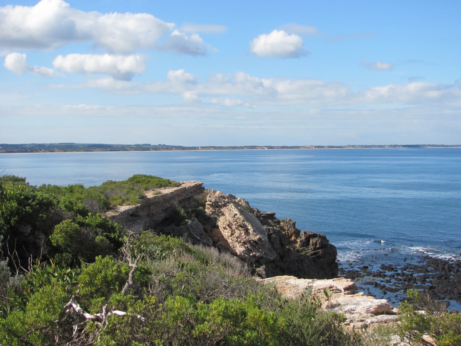
Remains of lime burning kiln at Limeburners' Point, East
Geelong
One of the earliest and most important industries to develop in the Geelong region was the production of lime which was in high demand by the building trade where it was used in the production of mortar, cement, plaster and stucco amongst other things. Lime production on the site is believed to date back to 1838 and the earliest days of European settlement in the region when limestone was quarried nearby and burnt in kilns on the western side of the point. Seashells were also collected and used in production. This site was no doubt chosen for the availability of limestone which was found in the cliffs, in the limestone gravel of the beach and in the shells which collected there. 
The limestone in the cliff face which is believed to be between 65 and 3 million years old was covered by a layer of clay, deposited in a later period. Other limestone deposits in the region are believed to have formed around 20 - 35 million years ago during the Oligocene-Miocene periods, when changing sea levels lead deposits of shells to form along shorelines which no longer exist. I wasn't able to discover how the deposit at Limeburners' Point relates geologically to these other deposits at places like Waurn Ponds, Fyansford and Batesford.
During the peak of operations at Limeburners' Point, the kilns operated day and night, burning timber which was hauled in on drays. Alternating layers of timber and limestone were fed into a funnel-like chimney at the top of the kilns which were stone and brick structures built into the cliff face. The contents were burnt, then the lime rendered by this process was collected from the chamber at the bottom of the chimney, bagged and carted away.
Remains of a bluestone quarry on the Barwon River
Initially owned by Messrs Taylor and Bourchier, the kilns were purchased in 1852 by George Cakebread from Caleb Joshua Jenner. Sources appear to differ on when the surviving kilns were built, however it would seem that these kilns date only to the 1860s or 70s. There are also the remains of a powder magazine at the site which dates back to 1854.
So important to the early building industry of the region was Cakebread's lime (the only other source of lime at that time was Point Nepean Peninsula) that it was shipped all over the Western District. I would imagine therefore that many of the significant homesteads of the region were built from rock quarried from basalt deposits along the Barwon and held together with mortar made using lime from the shores of Corio Bay.
One such example is Sladen House, Newtown which was built in 1849 with basalt taken from Melville's Quarry on the river at the bottom end of Noble Street. The first to do so.
Sladen House
Quite a number of quarries operated in this area: on West Fyans Street either side of Shannon Avenue, at Windmill Reserve overlooking Queen's Park and also near the end of Camden Road. All tapped into the deposits of basalt along the Barwon Valley, providing stone for local churches such as the Wesleyan Church in Noble Street, houses and even the Geelong-Queenscliff railway line.
Another example perhaps is the privately owned Barwon Bank in Riversdale Road, Newtown which was constructed between 1853 and 1856 from - I assume local - basalt, trimmed with freestone from the Barrabool Hills. Likewise, Barwon Park Mansion at Winchelsea is also built from basalt.
In addition to these buildings, Barwon Grange, Kardinia House and St. Albans Homestead along the banks of the Barwon are all brick, or stone and brick, structures built between 1850 and 1875 which presumably used Cakebread's lime.
Despite this overwhelming need for lime, pressure from tourist interests at nearby Eastern Beach soon saw the lime burning process forced to move to the eastern side of Limeburners' Point where these remaining kilns are situated. Production was not affected by the move and reached a peak in the 1870s, however nothing lasts forever and by 1875, another lime-burning operation located on the opposite side of Corio Bay at Duckponds (near Lara) was producing a superior quality lime. By the 1880s only one of the kilns at Limeburners' Point remained in operation and profits had dropped ten-fold.
Barwon Bank
The new producers had set up their kilns on the shores of the small lagoon into which Hovell's Creek empties. Somewhat confusingly, this is now known as Limeburners' Bay. At that time however, the entrance to the lagoon was known as  Limeburners' Point, with the site which is known by that name today, instead called Galena Point.
It is also worth mentioning that Duckponds and Limeburner's Point weren't the only source of Limestone in the region. The deposit near Waurn Ponds - an extension of which reaches to the Barwon where it forms the Belmont Escarpment - is still being quarried to make cement by Blue Circle Southern Cement Ltd. The stone is also used for monument-making purposes by various stonemasons in the region.
Historically, it seems that quarrying took place at Waurn Ponds as early as the 1840s, however it was probably only used for building purposes at this time. It was not until the 1880s when production at Limeburner's Point was in decline that kilns were built at Waurn Ponds and lime production began.
A little later, in 1890, the cement works at Fyansford commenced operation. The lime to supply these works was quarried about 5.6km away at Batesford from the Miocene era deposit which was found there in 1888. The rock was crushed on site and then transferred to the works at Fyansford first by a ropeworks and then by rail. With the opening of a new quarry in 1931, stone was loaded straight onto trucks and then taken to the works by rail for crushing. This open cut quarry is still in use today, despite the closure of the cement works.
Further research has just shown me that there was almost a very direct link between lime production in Geelong and the Barwon River. In the early 20th century the Fyansford Cement Works needed to get their product to the rail lines which would take it to Melbourne. Before the route from North Geelong to Herne Hill was eventually chosen, two other options were put forward. One was a railway line running from South Geelong through Newtown and Chilwell and then along what would become Deviation Road, whilst the other involved a siding running from South Geelong Station to the Barwon River and a wharf at Yarra Street. A second wharf upstream at Fyansford would be serviced by an aerial ropeway from the cement works. This plan however was overlooked in favour of the branch line from North Geelong.

27 August, 2011

In the beginning...

It occurred to me recently that I knew very little about the geological origins of the Barwon River, so I set out to redress the issue, but found I was suddenly in some danger of having a great deal of information but very little in the way of understanding. I spent some time sifting through what I could find online and trying to put it in some kind of order. As I understand it, the geological evolution of the Barwon runs very roughly along the following lines:
Cretaceous rock formations at the West Barwon Dam
in the Otway Ranges
Several million years ago, the landscape surrounding the Barwon River looked rather different to what it does today. In fact, the formation of the Barwon dates back as far as the Cretaceous period (70-145 million years ago) when Australia separated from the super-continent Gondwanaland and dinosaurs still roamed Earth. During this period, sedimentary rocks were laid down which can still be seen to the south of the Barwon as rocky outcrops in some places. They also lie off the coast of western Victoria in the Otway Basin.
As recently as 40 million years ago, much of the land through which the Barwon now flows was covered by a wide sea. Early streams flowed from the higher ground of the Otways, northwards to the sea and limestone deposits formed along this ancient coastline.
Limestone outcrop forming the Belmont Escarpment
The Belmont Escarpment overlooking Barwon Valley and the Jerringot Wetlands is one such limestone outcrop, formed between 25 and 30 million years ago, which extends from a large deposit at Waurn Ponds towards Corio Bay.
More recently, during the Miocene period (7-23 million years ago) a series of plate movements and volcanic eruptions saw the coastline extending as far inland as the town of Meredith and the estuary of the Barwon located at Belmont Common. At this time, much of the present course of the Barwon lay under the sea with only a few nearby features such as the ancient granite of the the Dog Rocks at Batesford protruding above the water's surface to form small islands. It was this sea which deposited the limestone which can be found in the Batesford-Fyansford area and which was quarried for use by the Fyansford Cement Works throughout the 20th century. At around the same time, clay and other materials laid down combined with the Batesford Limestone to produce a band of sedimentary rock running down as far as the eastern fringes of Lake Connewarre. This is known as the Fyansford Formation.
Continuing plate movement throughout the Miocene period affected the various fault lines around the Geelong region such as the Bellarine Fault, causing the Bellarine region to lift and then around 20 million years ago, the sea to withdraw, uncovering the land and the current course of the Barwon.
Plioscene basalt rock formation beside the
walking track to Baum's Weir
Subsequent sea movements in the early Pliocene period (3.5-5 million years ago) resulted in the formation of a shallow bay between Torquay and Ocean Grove, covering the lower reaches of the Barwon once again and led to the deposition of shell beds which now lie under this part of the river including Lake Connewarre and surrounds. Sedimentary deposits across the region including the Bellarine Peninsula at this time produced what is called the Moorabool Viaduct Formation. In places it lies over the top of the Fyansford Formation.
It was also around this time that the movement of fault lines pushed the Cretaceous rocks of the Otway Ranges to their current height, giving the Barwon the strength to carve a path to the sea through new lava flows which occured in the later Pliocene era.
It was at this time that volcanic activity around Mount Duneed, Mount Moriac and Mount Pollock led to further changes in the river and the landscape. Until about 2 million years ago, the Barwon followed a course which saw it flow through a gap in the Barrabool Hills south of Lake Modewarre, then down a valley adjacent to the hills before reaching Fyansford. Around 2 million years ago, lava flows north of Inverleigh blocked this course, causing the inundation of the land to the west of Winchelsea before the river once again carved a new path to the sea. The lava flow followed the old riverbed, leaving a deep basalt deposit in this area and contributing to the wide basalt plains which extend across the region, providing extensive farming land today.
Newly-arrived European settlers were quick to see the material value of these basalt deposits, establishing bluestone quarries along the banks of the Barwon. It is this rock which can still be seen in the stonework of many historical homesteads and buildings across the region - the Barwon Paper Mill and its water race being a prominent example. Naturally, this quarrying made a lasting impact on the river surrounds. This is particularly noticeable along the walking track to Baum's Weir where the quarrying exposed the pliocene basalt, leaving high, rocky escarpments which tower over the river below, whilst a number of quarries were located along the river through Newtown which today have been converted to parkland.
Disused bluestone quarry at Baum's Weir showing
pliocene basalt deposits
At the same time, these lava flows extended out into the bay with three branches forming which dammed the lower Barwon in several places and created a number of lagoons - including a lake at Queen's Park, with another blockage below the Belmont Escarpment.
One of these flows produced the basalt ridge line which runs between Tait's Point and Fisherman's Point, separating Reedy Lake and Hospital Swamp from Lake Connewarre and Salt Swamp. As a result, Reedy Lake was fed by fresh water from the now-dammed Barwon whilst Lake Connewarre and the swamplands below the ridge were filled with seawater.
In time however, the barrier at Queen's Park along with that at the Escarpment eroded away, creating alluvial flats downstream. Likewise the lava flow at Tait's Point and another between Sheoak and Pelican Points which had obstructed the river flow were eroded away and water from the upper Barwon and Reedy Lake once more flowed into Lake Connewarre and the lower reaches of the river. This reconnected watercourse now ran alongside the third lava flow which extended to The Bluff and Ocean Grove, establishing the present course of the lower parts of the river and location of the river mouth.
Remains of basalt flow from the late Pliocene era
 forming Tait's Point (right)
It is believed that much of this erosion occurred during times of high flooding - such as 1995 - and as a result of seismic movement. The returning flow of water along with fluctuations in sea levels during the late Pleistocene period (c18,000 years ago) resulted in the build up of sand dunes along the southern basalt flow. In very recent times, with European settlement, this natural rate of sedimentation has been greatly increased by land-reclamation, farming, tree clearing and for a short but intense period, mining in the catchment region of the Moorabool River. All these factors have contributed to sedimentation, causing in-filling which has affected the depth of water in the lakes complex, turning Reedy Lake from an open water system to the swampy complex it has become.
In addition to the various geological and environmental events which shaped the course of the river, across millions of years, continuous erosion and subsequent sedimentation have also influenced the soil of the region, forming the land we see today.

21 August, 2011

I see red! I see red! I see red!

Thursday, I had a few spare hours so decided to head back to Tait's Point and Barwon Heads to see if I could manage any more success with the camera than I did on Tuesday.
Immature Pacific Gull
At Tait's Point I saw the falcons circling, heard the kites, saw the parrots and rosellas between the leaves but once again couldn't get a clear shot of anything. So, back in the car and off to Barwon Heads. I parked near the bridge and decided to walk across to the opposite side to take a few shots of the Heads from that direction. I was pleased to discover a pair of immature Pacific Gulls wading in the shallows of the incoming tide. As I approached, they kept their distance, but remained close enough that I could get some decent shots. As I snapped away, one disappeared only to return a few minutes later with a late lunch in the form of a small fish in its beak. Very cute, but not for the fish, I'm guessing.
Also cute were the flock of tiny wading birds which I discovered scurrying in and out of the shallows ahead of the incoming tide, constantly moving, looking for food. Reasonably unconcerned by my presence, they also let me snap away at will. Occasionally, they would fly up as a flock and then quickly settle again a little further along the shoreline, never too far away and always looking to see what the tide had delivered them.
Red-necked Stint
I hadn't seen them before so had no idea what they were. Initially I assumed they were all variations of the same species. They moved together as a flock, were similar in size and colouring and clearly fed the same way. All had white underparts and the majority had mottled brown backs. Some however, had red caps, brown backs and a black eye stripe extending from their beaks past their eyes.
It was not until I took my "catch" home and uploaded it then did a little research that I discovered that I was actually looking at two different species of birds. One - the mottled brown type - was I discovered the Red-necked Stint. The other with the red cap was in fact a Red-capped Plover.
Red-capped Plover
The stints had arrived from the Arctic regions of Siberia and Alaska where they breed during our winter months before travelling thousands of kilometres south, arriving - right on cue - in late August. The Plovers are wading birds like the stints, however by contrast, they are non-migratory, living here year-round throughout the country.
Either way, on this occasion, both species appeared to be foraging happily together in the shallows of the Barwon as they allowed me to take my shots.

19 August, 2011

The end of it all...

The Barwon River rises in the Otway Ranges, flows down across the plains and reaches the sea at Barwon Heads. This point where the Barwon meets the sea is one of the more spectacular parts of the Victorian coastline.
Looking back up the Barwon River from The Bluff, Barwon Heads
I've spent time on the beach beside the river, photographed the bridge, walked down the main street of Barwon Heads and been to the Ocean Grove surf beach but I'd never really walked up over The Bluff and looked back up the river from beyond the bridge.
The ocean beyond Barwon Heads
The sea views from here are wide and extensive. To the east, the Point Lonsdale light house on one side and Point Nepean on the other clearly mark the narrow entrance to Port Phillip Bay.
Looking towards the entrance to Port Phillip Bay from The Bluff, Barwon Heads
To the west, the coastline stretches away into the distance towards Thirteenth Beach and Torquay beyond.
View towards Torquay from The Bluff

From inside the Heads, the views out to sea are no less impressive where on a clear day, the views take in the breakers off The Bluff and the ocean beyond..
View towards the Heads from the Barwon Heads Bridge
When I took the photo above, the tide was coming in and it was easy to see the water surging back upriver, past the bridges, swirling around the pylons. A single cormorant was taking advantage of the tidal flows to make a quick trip upstream. The riverside beaches which are packed with swimmers in summer could hardly be seen but whilst it was no weather for swimming, quite a number of suitably insulated surfers were making the most of the waves beyond the Heads.

17 August, 2011

Gone with the wind...

Ducks on Hospital Swamp
Yesterday I headed back to Tait's Point - via Hospital Swamp - and then to Barwon Heads hoping to get some better bird shots to add to the ones I took last week. Great idea...in theory.
The scene was set as I headed around Lake Road when I saw what was quite possibly a Black-winged Kite perched on a fence post. Coming to an abrupt halt, I grabbed the camera only to see my quarry heading for a distant tree.
Things continued in this vein when at Hospital Swamp I didn't get a clear shot of several Crimson Rosellas or a Black-faced Cuckoo Shrike. Round at Tait's Point I didn't get a good shot of a pair of Eastern Rosellas. The Brown Falcons were circling, the Whistling Kites were doing just that but all far enough in the distance that there was no chance of a photo and there was no sign of the cuckoos or greenfinches I saw last week. Even the swallows seemed to have better things to do.
Not a good start.
Crested Tern at Barwon Heads
Whilst the weather was relatively mild and sunny in patches, it was rather windy, blowing in from the north and east I judged. I have noticed in the past that the jetties near the Tait's Point car park are a favourite spot for the cormorants to perch and dry their wings. I have also noticed that some days they use both jetties and on other days they prefer one to the other, making me wonder if one offers more protection than the other. Today, they were absent altogether. Also missing in action were the hundreds of ducks, swamphens and cormorants which I saw on Hospital Swamp last week.
Clearly they know more about the weather than I do and know a cool easterly wind when they feel it and had decided that today was not the day to be out on the lake. Of course, the sport of fishing is also quite weather and wind dependent, so perhaps the birds know that an easterly does not make for good fishing at this location.
Nankeen Kestrel over the Bluff at Barwon Heads
What ever the reason, I left empty handed on this occasion and decided to try my luck at Barwon Heads. Not surprisingly, it was quite windy there too, but some of the coastal birds to be found at the Heads are obviously made of sterner stuff than those on the lakes. The gulls as always, were in attendance and a whole raft of smaller birds were making themselves heard - but unfortunately not seen - from the scrub near the Bluff. On the rocks below I spotted a tern - the first I'd seen and then above I noticed several Nankeen Kestrels making use of the air currents to float over the edge of the cliff face before diving down upon their prey. Again and again they took to the air, hovering, waiting and then descending like a rock on some unsuspecting creature below. So good are the kestrels at hovering, that it made for a rather good photo opportunity even with my limited equipment.
So in the end, I was left with several reasonable photos and even more questions about the effects of prevailing wind patterns on bird behaviour - but with no obvious answers.

13 August, 2011

Go Fly a Kite

...or more precisely, go watch the kites flying. And I do occasionally. Here and there I have seen parents and their kids out flying kites in the parks along the banks of the Barwon. Last week as I was riding home, there was a kite flying above Balyang Sanctuary - probably from King Lloyd Reserve on the opposite side of Shannon Avenue.
Of late, the kids have expressed an interest in kite flying, so it looks like I'll have to invest in a new toy and get out there, hopefully creating a few photo-opportunities along the way. In the meantime, I will have to settle for photos of a different kind of kite.
Whistling Kite
Last week during a trip to Tait's Point, I wandered along the shore of Lake Connewarre, making my way round to Hospital Swamp - an area of the lake complex which I hadn't seen before. Not far from the parking area at Tait's Point, I was following the rough track which leads along the edge of the lake, keeping an eye and ear out to see what birds might be around. At this point the bank is well above water level and the land around is open farmland covered with long grass.
To my left, I suddenly noticed I was being observed by a large raptor which was standing quietly, almost completely camouflaged amongst the grass. I carefully snapped a few photos, watched closely the whole time. I moved a little closer, hoping to get a better shot and to minimise the amount of grass impinging on the shots. My subject however, was having none of that, and immediately took to the air, circling overhead and confounding my attempts to take even one respectable aerial shot.
It vaguely crossed my mind that such birds often hunted in pairs, but unfortunately I did not consider this seriously enough and as I moved off, a second bird took to the air. Eventually I abandoned my attempts at mid-air photography - doing this properly would require a significant upgrade to my photographic equipment and probably some specialist training. Neither is likely to happen any time soon.
So, hoping I'd taken at least one decent shot, I moved on a little and discovered a flock of red-rumped parrots perched - as they are wont to do - on the branches of a dead tree. Not particularly fazed by my presence, they twittered away whilst I snapped my shots. I moved in closer - still no reaction from the parrots. At that point however, one of the raptors (I had yet to identify them), swooped low overhead. What had been a tree full of parrots, very quickly became nothing more than a dead tree once again. Clearly whilst I was not considered to be a significant threat, the same could not be said for the large bird of prey overhead and the parrots made themselves scarce very quickly.
Meanwhile, I continued my walk, heading round to Hospital Swamp which I found to be home to many dozens of ducks, cormorants, swans and even an egret. I spent another hour or more taking photos and wandering around whilst above, the large birds continued to circle.
Eventually, I headed home and did some research which informed me a) that my raptor was a Whistling Kite and b) that there were many better photos around than the ones I'd managed to snap. Oh well, at least I now had proof of another species of bird living by the river - two actually, including the Great Egret I'd seen.
Brown Falcon
Buoyed by my "discovery", I headed back to Tait's Point a couple of days later, snapping more photos of several other species I hadn't seen before, including a European Green Finch, a Brush Cuckoo and a very obliging  Fan-tailed Cuckoo which was more than happy to pose for me. Once again I was pleased to note a pair of large birds circling overhead.
The weather was better on this occasion than two days earlier when I'd returned home with some good photos but very wet feet. Today I had good photos and dry feet. Great! Then, having decided I'd done enough for the day, I headed back the way I'd come. As I approached the point where I'd seen the kites two days earlier, I suddenly spotted what I thought was one of the same pair sitting on the branch of a dead tree. Carefully, I snapped several shots, closely observed once again. Also like last time, I attempted to approach a little closer only to have my quarry take to the air. So, again, I admitted defeat, headed for home and downloaded the new batch of photos only to discover that this raptor was not the kite I had seen the previous day. Instead, it was a Brown Falcon, a smaller, stockier bird with differently coloured plumage.
And so I had another bird to add to my tally. All in all another successful outing and a little better educated than before. Now to teach the kids how to fly a kite...

06 August, 2011

Spring is - almost - sprung!

With the weather we've had over the last four days, you could be excused for thinking spring has come early. It always happens about this time of year - a burst of mild weather which provides some very welcome relief from the drudgery of winter. Some of us however, know better than to be fooled by this false "spring".
Today, the weather turned again. The clouds returned, the air was cool and eventually, the rain came. The avian population along the banks of the Barwon however, had not yet noticed this change in the weather. Out for one of our regular Friday rides, I couldn't help but notice that the birds were in full flight.
As I rode, I did my usual head count, noting the number of different species out and about on this particular day. By the boat sheds and through town there were the regulars - moorhens, coots, rock doves (pigeons), seagulls, pacific black ducks, plovers and a single wood duck. All along the river as I headed towards Fyansford, the rainbow lorikeets were everywhere, screeching and chattering, zooming overhead with their rapid wing beats. Above the Deviation it seemed the Currawongs were having a convocation whilst on the common at Fyansford, the swallows and red-browed finches were trying to prove the approach of spring by sheer weight of numbers. A pair of laughing kookaburras were doing just as their name suggested on nearby Redgum Island and the red-rumped parrots which frequent the dead gum tree near the foot-bridge over the Barwon were out and about too.
Snake sculpture, Barwon River
As we made our way along the Highton side of the river, heading towards Prince's Bridge, we stopped briefly at the snake sculpture, carved from a log and from there wandered down to the decked area to have a look around. Not exactly a new experience for me, but there was a noticeable difference today. Overhead were yet more noisy birds. Here and there I could both see and hear a sulphur-crested cockatoo - who wouldn't? But there were also quite a number of similarly-sized birds, with a similar call to a cocky, yet without being so raucous or loud. They were grey in colour with what at that distance appeared to be some pink on them. Possibly Galahs, but given that their call sounded rather like a squeaky door hinge, I figured probably not. I thought I knew who these birds most probably were, but it was not until we made it round to the other side of the river - where we stopped at Barwon Edge for lunch - that I was sure.
There I found them, located at a convenient height for photography in a eucalypt - one of their preferred food sources - crunching away on gum nuts. This was only the second time I had seen gang gangs on the river (or anywhere for that matter), with the previous occasion being only a few weeks ago a little further downriver at Barwon Valley.
Male Gang Gang Cockatoo
Female Gang Gang Cockatoo
My favourite website for all things bird related - Birds in Backyards - promptly informed me that their call sounded like a rusty door hinge. Thanks, but I'd already figured that one out for myself! It also told me that these rather cute birds are predominantly left handed - almost always using their left claw to hold their food - now that I hadn't noticed. A quick glance through my various photos seemed to bear this theory out. I was also unsurprised to see that the website agreed that gang gangs can look somewhat like a galah in flight.
So much for gang gangs. We took our photos, ate our lunch and moved on, heading back towards Fyansford. The weather by now was starting to close in a bit, with large dark clouds massing overhead. Regardless, I was keen to continue riding, so off we went again. The birds it seemed, were still unconcerned by the impending weather. In addition to those mentioned already, we saw new holland honeyeaters, blackbirds, spotted doves, superb fairy wrens, the ever-present red wattlebirds, mudlarks, magpies, Australian ravens, willie wagtails, even a darter and a heron. At several points I could hear the grey butcherbirds in the trees beside the track, but didn't manage to catch sight of any.
Eastern Rosella
As I made my second pass of the Fyansford Common I spotted a small group of crested pigeons in the grass and then, as always when I pass the Queen's Park Golf Course, I kept an eye - and ear - out in the hope of seeing and then taking a decent photo of an Eastern Rosella. This is the only part of the river on which I've seen them and even then only on one occasion. This time, as I passed a dead tree where I know red-rumped parrots often hang out, I heard some soft voices in the trees above. Telling myself it was the parrots, I almost kept going, but on second thoughts, I back-tracked and had a look up. Not parrots, but those eastern rosellas I'd been looking for.  Great! Now to get a photo - or perhaps not. By now, the light had seriously started to fade, the threatened rain was just beginning and rosellas as I have discovered are notoriously scatty when it comes to standing still long enough to get a decent shot.
Today this proved to be exactly the case. The low light and nervous birds left me with three grainy photos to show for my efforts, so it appears I will have to continue my quest for the perfect snap. In the meantime, to the left is one I took earlier.
So, with the clouds continuing to pile up, the rain beginning to come down a little more persistently and the temperature back to far more wintry levels, I headed for home. The birds were still on the move, particularly as I passed Balyang Sanctuary where the sulphur-crested cockies were creating a racket and there, perched amongst them trying to look like one of the crowd, I also spotted a solitary corella.
In all I think, about 29 different birds. Not a bad effort given that I have so far only seen around 70 species along the entire length of the river. So, only slightly damp and with a few more kilometres under my belt I made it home once again.