22 May, 2016

Mapping the Barwon Catchment

Before the arrival of John Batman and his party on the shores of Port Phillip Bay in 1835, the indigenous tribes of the Barwon catchment walked the land, following traditional "songlines" which had evolved over thousands of years. The songs and stories of the many tribes, described the land and the physical pathways they used to cross the countryside, enabling them to navigate long distances, passing safely through unfamiliar territory. I discussed songlines in my previous post.
Europeans on the other hand, saw the land very differently to the indigenous population and used very different navigation techniques. The Europeans too used maps, however they drew their maps on paper, measured distance, calculated elevations and aligned everything according to compass bearings. And they way they travelled was vastly different too. Whilst many still walked, others rode horses and drove bullock drays and it wasn't long before the paths of the songlines became the bullock tracks of the squatters. They in turn were followed by the surveyors with their chains and newfangled theodolites who marked out the roads of the selectors and villagers.
The settlers were also quick to start applying their own mapping techniques to their new surroundings. The squatter's runs were plotted out and the bullock tracks which linked them with the towns which began to pop up, were marked as vague wavy lines.
Section of Surveyor Alexander Skene's 1845 map of the Geelong District
showing early tracks and the names of squatters and early landholders
across the catchment. Original image held by the State Library of Victoria
The more the number of settlers increased however, and the more they extended the boundaries of their settled districts, the more maps were created. Not only did these maps indicate direction and location, but there were also administrative maps, electoral maps, geological maps, maps which indicated individual land ownership (an unfamiliar concept to the indigenous peoples), weather maps and many other types of maps besides. Soon the entire colony had been layered with maps and amongst the earliest of these maps were survey maps.
In order to better administer the vast areas of the new colony, the land was formally divided for the purpose of administering the sale and distribution of land. From the late 1840s until the 1890s, the government progressively undertook a comprehensive survey of the  Colony of Victoria, reclaiming the squatters' leaseholds and breaking up the thousands of acres into village allotments and farm-sized blocks. To aid administration, county boundaries were established and within each county the land was subdivided into civil parishes.
Portion of the Victorian Counties Atlas, 1874, showing those counties which fall
within the Barwon Catchment. Image taken from the State Library of Victoria
Initially, the county boundaries were by necessity ill-defined and changed according to need. The following description from the Geelong Advertiser 17th July, 1841, claiming to give the first official description of Grant County's limits, shows both how they changed over time and - like the Wathaurong whose lands it covered - how the new settlers also used the natural landscape to define boundaries.
The Coast Line from the mouth of the Werriby(sic), Port Phillip, round to a point bearing south of the sources of the Barwon [Barwon Heads]. An imaginary line from that point to the sources of the Barwon [the Otways]. the Barwon from its sources to its junction with the Native Hut Creek. The Native Hut Creek from that junction to the Buninyong and Melbourne road(sic). The line of that road to the Werriby, and The Werriby River to its mouth.
By 1871, the 37 Victorian counties as we know them today were in place. Counties and their accompanying civil parishes were - and still are - used entirely for real estate purposes, enabling the physical description of a piece of land.
Section of 1881 Victorian civil parishes map. Original image held by the
State Library of Victoria
With European settlement came the English system of government. Having been declared a separate colony from New South Wales on 1st July, 1851, Victoria needed to put a government in place, however it was not quite the system we have today. The original Victorian parliament was unicameral - having only one house. Called the Legislative Council, it was composed of 16 electoral districts from which 30 members were chosen. Ten were nominated by the Lieutenant-Governor and 20 were elected from the eligible voting population. To be eligible to vote a person had to be a male British citizen over the age of 21 who paid more than £10 per annum in rent or held the freehold for property valued at more than £100. Once again the colony was mapped and divided. This time for electoral purposes. The Wikipedia map below shows the original electoral districts and I have indicated the general area of the Barwon catchment within the black box.
Electoral districts of the original Victorian Legislative Council, 1851.
Original image from Wikipedia
Within a handful of years however, electoral boundaries were being shuffled and in 1856 a second or lower house - the Legislative Assembly - was introduced, resulting in the system we have today.
State electoral districts for both the upper and lower houses of the Victorian parliament have continued to change in response to the growing population. Today there are 88 electoral districts, each corresponding to a seat in the Legislative Assembly. These are combined into eight districts from which five Legislative Council members are elected, giving a total of 40 members in the upper house.
Current boundaries of the state electoral districts (lower house) which
cover the Barwon catchment. Original image from Wikipedia
In 1901, the cartographic landscape of the Barwon catchment changed once again with the advent of Federation. The Colony of Victoria became the State of Victoria and was divided for the purpose of voting into federal electoral divisions. These were (and still are) different to the electoral districts of the state government. The electorates of Corangamite, Ballarat and Corio are all, at least in part, within the catchment.
Federal seats within the Barwon catchment. Original image from Wikipedia
Of course, beneath the federal and state levels of government is local government. In the 19th century, local government stemmed from the need to raise funds for roads and infrastructure, consequently a series of "road districts" were gazetted across the colony. Within a few years, the road districts were transformed into shires which along with cities and boroughs today make up the various municipal districts of the local government system. Not surprisingly, as with state and federal electorates as well as county and parish boundaries, the banks of the creeks and rivers of the Barwon catchment often formed the boundaries of these early shires too. Also in keeping with other levels of government, the number of municipal districts has changed over the years. For instance, in 1915, the Shire of Meredith was amalgamated with that of Bannockburn.
Country Roads Board map, 1961 showing parish boundaries. Original image held by the
State Library of Victoria
In 1994, sweeping changes saw the amalgamation of many smaller shires and city councils in to a lesser number of much larger shires and cities. Where before the catchment contained perhaps as many as many as 15 shires and cities, after the amalgamations, this number fell to around six.
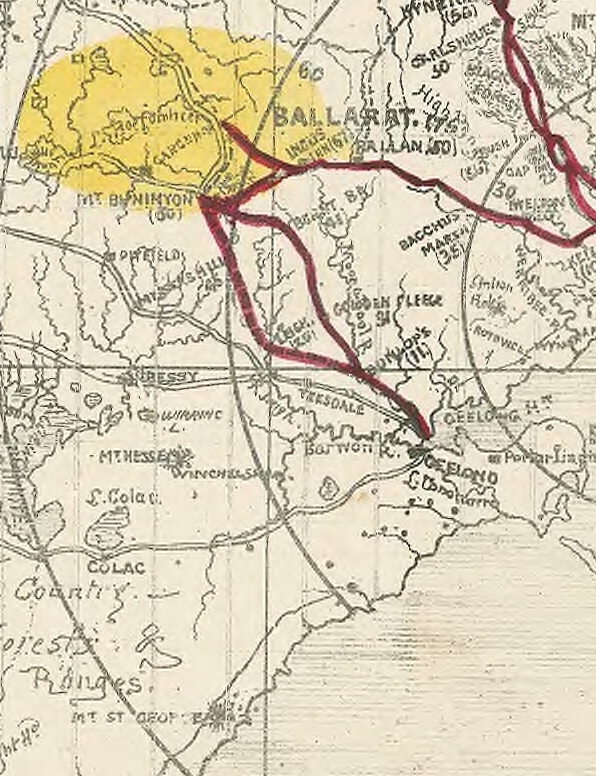
The outbreak of the Victorian gold rush in August, 1851 also saw a flurry of map making. Every digger wanted to know the best route to get to the diggings. As I have written before, there were claims, counter claims, insults and outright lies hurled back and forth between parties with vested interests in promoting their route to the diggings. Maps could not only be used to inform the general public (as below), but also to deceive as Geelong discovered when interests in Melbourne published a "false map".
The relevant section of a reasonably accurate "Digger's road guide to the gold mines of
Victoria and the country extending 210 miles around Melbourne", 1853. Image taken from
the National Library of Australia
 As well as the topography of the land and the roads and tracks which crossed it, the gold rush led to an intense interest in what lay under the surface of the soil. In 1852 Alfred Selwyn was appointed as Mineral Surveyor for the Geological Survey of Victoria and with one assistant and a tent-keeper, set about completing a comprehensive geological survey of the colony. Soil types were assessed, rock deposits dated and the potential presence of minerals noted. Over the years, the department expanded and exists today under the portfolio of the Department of Energy and Earth Resources in the Department of Economic Development, Jobs, Transport and Resources.
Adaption of the 1909 Geological Survey Map of Victoria. Image held by the
State Library of Victoria
Finally, another topic which has always been of particular interest to those living in the Barwon catchment. Rainfall. How much? How little? When? Where? Once again, the indigenous tribes had intimate knowledge of seasonal changes in climate and climate-dependent resources. The European settlers were equally as interested. They needed to know when to plant their crops and where to find water for their stock in different seasons.
Meteorological recording began in Melbourne as early as 1840 and regular, coordinated data collection began in 1854 with the establishment of the Victorian Meteorological Office. The first official report of rainfall data (I could locate) for Geelong appeared in the Victorian Government Gazette dated 21st August, 1857 for the April-June quarter of that year, although references were made elsewhere to earlier data.
Today, rainfall measurements are taken at various points across the Barwon catchment, including Weeaproinah in the Otways, near the headwaters of the Barwon River which has the highest average rainfall in the state. By contrast, the lowlands along the lower reaches of the Barwon, Leigh and Moorabool Rivers lie in the rain shadow cast by the Otway Ranges and receive a significantly lower annual rainfall.
Overview of long term rainfall averages for the Barwon catchment. Graph taken
from the Australian Bureau of Meteorology
Over the years since European settlement, many maps have been produced for many different reasons, dividing the catchment in a multitude of ways. Maps to direct. Maps to divide. Maps to quantify. Maps to persuade, even maps to deceive...

17 May, 2016

Songlines of the Barwon Catchment

During the recent Mountain to Mouth 2016 extreme arts walk held across the City of Greater Geelong and the Borough of Queenscliffe, one of the catchphrases used was "walk this land". Participants were encouraged to consider those who have walked the land before us. Part of our route took us along the Barwon River, with the event ultimately concluding on the banks of the river at Barwon Heads.
With this in mind, I thought I would have a look at the lands of the wider Barwon catchment and the people who have walked them. The way we cross the land today is perhaps best represented by maps. For thousands of years before the arrival of Europeans however, the indigenous tribes of Australia walked the land, following ancient tracks and pathways known to their ancestors, without the benefit of modern cartographic techniques.
For 25,000 years prior to the arrival of Europeans, the Barwon catchment was home to three indigenous tribes. The lands surrounding the lower Barwon - downriver from Winchelsea - as well as the catchments of the Moorabool and Leigh/Yarrowee Rivers were occupied by the Wathaurong (Wadawurrung) people. The lands of the Gulidjan Tribe lay along the upper reaches of the Barwon, also incorporating the area around Lake Colac. The Barwon itself formed the boundary between the Gulidjan people and their southern neighbours - the Gadubanud Tribe - who lived on the land between the river and the coast, stretching westwards past Cape Otway.
Adaption of the map "Catchments of the Barwon River and inland Basins", created
by the Victorian State Rivers and Water Supply Commission, 1950 (original
image held by the State Library of Victoria). Clan territories estimated from
Clark, 1995, "Scars in the Landscape"
Rather than physical maps such as the one above, indigenous maps were shared through dance, song, painting and story. They talked about the features of the land itself; the rivers and creeks which showed them the way from one place to another, the hills, the trees, the rocks, the waterholes passed along the way. Even the sky played a role. Following these "songlines", it was possible to walk for hundreds of kilometres. In this way, people could move between tribes, establish trade routes, make marriages, manage natural resources; walking - it was believed - in the footsteps of the creator spirit.
And it isn't too much of a stretch to see how songlines could work. The name of the Barwon itself is a directional description. Barre Warre N Yallock - the big river which flows from the mountains to the sea. Follow this river and you will reach the sea. Kooly bar ghurk (Coolebarghurk): man's track by the creek. Another descriptive name. Which track? The one by the creek. The one made by people, not the many animal tracks which no doubt criss-crossed the land.
"Man's track by the creek". For thousands of years, the Wathaurong walked the
banks of Coolebarghurk Creek
Wormbete: which lake? The "lake with the black fellow's mound". Where? Bukar Bulac; the place between two rivers. This was the Wathaurong name for the confluence of the Moorabool and Barwon Rivers.
Creation stories told how the eagle Bundjil looked down upon the world from the sky where his fire (the planet Jupiter) could be seen from Earth. Bundjil it was said, made his earthly home at Woringganninyoke - Lal Lal Falls. Whilst the meaning of the first name is unknown, "Lal Lal" is said to mean "dashing water in a crevice". Another literal description which could contribute to a songline.
Lal Lal Falls, April, 2012
Many other sites were named for prominent features which could also be used as part of a songline. Someone wanting to journey north west from Jillong (Geelong), the "place of native companions" or the place "where the seabirds fly over white cliffs", could perhaps travel to Durdidwarrah where either a "shelter of bark" or "dead water" could be found after which they would reach Bungeeltap (meaning either "spirit water" or "eagle's nest"). From there, they could see [Mount] Warrengeep (Warrenheip) where the ferns of the side of the mount resembled "emu feathers" before passing Bonan Yowing (Buninyong), the mountain shaped like a "man lying on his back with his knee raised." Once there, it wasn't too far to Balla arat (Ballarat), the "reclining on the elbow" "place" or resting place.
Bonan Yowing: Mt Buninyong, visible across the surrounding countryside
for many kilometres
Like today's Google Maps, the songlines of the indigenous peoples not only described which route to follow, but gave tips about where to stay and what food could be found along the journey: Yarram Mordong (the Wathaurong name for Buckley Falls), waterfall [of] eels; Porrong Goop (Borrongoop), the place of quails; Koo N Warre (Lake Connewarre), mud oyster water.
Koo N Warre: Lake Connewarre
In this way, the Wathaurong, Gulidjan and Gadubanud Tribes of the Barwon catchment "mapped" out the land, preserving their knowledge over thousands of years for future generations. Until European settlers arrived...

11 May, 2016

Mountain to Mouth 2016: 80km of extreme arts

My previous post on Geelong's Mountain to Mouth 2016 described our participation in the Gathering of the Elders ceremony at Big Rock in the You Yangs before a 30km walk to the Geelong Waterfront for the Gathering of the City ceremony. This post will look at the rest of the walk (50km) which took place the following day beginning at 6am Saturday morning, whilst the walking circles and installations we passed at stations along the way are shown here.
Under cover of darkness, "Canoe" prepares to depart the Waterfront
Carrying "Canoe" up Moorabool St with a one-man police escort
Unlike the previous event, the weather was clear and perfect for an early morning walk. We departed the Waterfront punctually, and made our way up Moorabool Street to the Barwon River and the sixth station - an interpretation of Eugene von Guerard's famous painting of the river and naturally of particular interest to me.
Centrepiece of the sixth walking circle
With the coffee van arriving late and a rapidly growing queue, I elected instead to walk the circle, snap some photos and depart slightly ahead of "Canoe". Somewhere during this 15 minute or so period, the sun came up and we walked the short distance along the river to Swanston St in daylight.
Following "Canoe" along the banks of the Barwon River
From there, it was onto the Bellarine Rail Trail for a long slog to Leopold and Station 7 at the top of the Leopold hill. As I have noted before, those of us who regularly use the trail are fortunate that steam trains did not like steep inclines.
On the trail
I was hoping I'd be in better shape than this truck by the time I finished!
Once at Christie's Rd, I finally got that coffee and a "Killer Python" (I needed those carbs for energy!). As I watched some of the walkers taping their blisters, I was very pleased I had taken the precaution of taping my feet before I started walking.
A bird in its nest - part of the Christie's Rd installation
Flag bearers ready to leave for Drysdale
And then we were off again. The section from Leopold to Drysdale was relatively short with some spectacular views along the way.
A mere 27km away from our starting point...yet we'd walked 50km...
In the distance I could hear the train ready to take a special service to our next stop at Swan Bay for those who preferred to give their feet a rest. Tempting! But I was walking the whole way!
Art and music; the centrepiece of the Drysdale walking circle
For the rest of us, it was back on the trail for the longest section of the whole walk - around 14km -between Drysdale Station and the Marine and Freshwater Discovery Centre at Queenscliff.
Not everyone was interested in an extreme arts walk...
...and these guys were sitting on the fence too..
Unfortunately for those of us not taking the train, it was also the hottest part of the day and probably the section with the least shade. The marshals on their bikes were keeping a close eye on those of us walking ahead until we finally made it to Queenscliff.
At this point the train was beginning to look like a good option!
The road ahead...
My feet were definitely beginning to feel it by now, but a quick rub and we were off to Point Lonsdale.
Basalt Banjo Ray walking circle at Queenscliff
 After the long, hot stretch to Queenscliff, the short walk around the foreshore to Point Lonsdale and the tenth station was relatively easy by comparison and I was provided with distraction in the form of a fellow pilgrim who was happy to chat as we walked.
A sand sculpture en route to Point Lonsdale
The Point Lonsdale Village station is unavoidably short on for space, so rather than a walking circle there was a sand sculpture to welcome us on the boardwalk and an installation which according to the description has "continual interaction of wind, sun, clouds and sea".
Sculpture to the left as "Canoe" and the flag bearers arrive at Point Lonsdale
At this point, "Canoe" and the walkers diverged slightly as we wove our way through the ti-tree and "Canoe" continued up the road, before we converged once again for the climb over the dunes to the beach.
The "path" ahead
Whilst the scenery on this section of the walk was spectacular and the soft sand under sore feet was initially somewhat of a relief, I knew from previous experience that this was not going to be easy. We had around 8km of sand to cross and an incoming tide to beat as well and sure enough it soon became a trudge, however eventually, I was greeted by the cheerful volunteers at station eleven: Ocean Grove.
Ocean Grove and the end of the sand at last!
After a short break as "Canoe" was delivered to the walking circle at a run by the Ocean Grove Harriers running group, we were off on the final 3km stretch to Barwon Heads. Just as dusk was falling, we tramped across the Barwon via the William Buckley Bridge and made our way around the final walking circle headed for the tent and that last stamp on the M to M passport which said for some of us, that was had completed the entire 80km.
"Canoe" arrives at Barwon Heads
All that remained then was to find a suitable vantage point and watch the final Gathering of the Elements ceremony played out on the the banks and the waters of the Barwon.
The ceremony begins
Actors and dancers took their places as shoals of "fish" with glowing eyes lit the sands and a lone boat paddled across the river. Uncle Bryon Powell, cloaked in traditional possum skin, handed over the water which had been carried from Big Rock and it was again returned to the ocean before "Canoe" once again took centre stage in a fiery finale which saw it set alight and left to drift on the waters of the Barwon towards the heads and the ocean beyond.
Fire on water
"Canoe", set adrift on the Barwon, floats out to sea


10 May, 2016

Mountain to Mouth 2016: ephemeral art

As described in the companion posts to this one (Walk this land and 80km of extreme art), Mountain to Mouth 2016 featured a central artwork taking the form of a canoe. As walkers crossed the landscape accompanying "Canoe" to its final destination at Barwon Heads, they passed a total of twelve resting points (or stations) along the route. Each station centred around an ephemeral art installation, generally in the form of a walking circle. The walking circles were designed to reflect their location and surroundings and to tie in with the over all theme of "air".
In total, over 70 local artists along with hundreds of community members were involved in the construction of these ephemeral artworks. Below is a photo of each installation or a feature of it:

"Canoe"

Add caption

Station 1 (You Yangs, Big Rock): Dance Circle

Station 2 (Lara RSL Hall): To The Four Winds

Station 3 (Limeburners' Lagoon): Grass Shrine

Station 4 (Moorpanyal Park): Blowout

Station 5 (Steampacket Gardens): We don't need wings to fly

Station 6 (Barwon River Rowing Precinct): Lost river view

 Station 7 (Christie's Road, Leopold): Grey tree

Station 8 (Drysdale Station): Hearth stories

Station 9 (Swan Bay, Marine and Freshwater Discovery Centre):

Banjo Ray

 Station 10 (Point Lonsdale Village): Wind worx 11.1000

Station 11 (Ocean Grove Surf Life Saving Club):

Air, water earth and dreaming

Station 12 (Barwon Heads Foreshore): Feather