Showing posts with label Leigh River. Show all posts

06 January, 2018

Gellibrand and Hesse

One of the most hotly debated tales of the early European settlement of the Barwon River is the story of "Gellibrand and Hesse". Over the years, much has been written about the disappearance of  Joseph Tice Gellibrand and George Brooks Legrew Hesse, somewhere near Birregurra early in 1837. From modern scholarly papers to the romantic but factually dubious accounts of the 19th century, the topic is well beyond the scope of a single or even a series of blog posts, however a general account may still be of interest.
 Gellibrand was born in London, England in about 1786 where he was admitted as an attorney in 1816. On 1st August, 1823 he was appointed the attorney-general of Van Diemen's Land and arrived in the colony to take up his post in March the following year, however his tenure in the position was short-lived. Within months of his arrival he came into conflict with Lieutenant-Governor George Arthur and by February, 1826 had been suspended from his position.
Joseph Tice Gellibrand
After his removal from office he continued to practise as a barrister, purchased land and in 1835 was one of the investors who formed the Port Phillip Association. It was Gellibrand who drafted the terms of what became known as the "Batman Treaty", signed by John Batman and elders of the Wurundjeri Tribe.
The "Batman Treaty"of 1835, also known as the 'Batman Land Deed'.
Item held by the National Museum of Australia
By early 1836 Gellibrand was in the Port Phillip District and undertook a number of exploratory trips before returning to Van Diemen's Land. In February, 1837 he once again crossed Bass Strait, this time accompanied by his colleague George Hesse. Like Gellibrand, Hesse was a lawyer. Born at Chichester, England on 1st July, 1798, he was a Cambridge graduate who was admitted to the bar in 1819. On 5th March, 1833 The Hobart Town Chronicle carried a notice declaring Hesse's intention to be admitted to practise law in Van Diemen's Land as a "Barrister, Attorney, Solicitor and Proctor" of the Supreme Court.
The pair, along with Mr John Sinclair from Launceston, landed at Point Henry, near Geelong on the 21st February, intending to spend a couple of days following the Barwon and then the Leigh Rivers upstream before turning east and passing behind the You Yangs to reach Gellibrand's own run on the Werribee River near present day Wyndhamvale. From there, they would return to the brig Henry which by then was expected to have finished unloading sheep and be waiting for them at Williamstown.
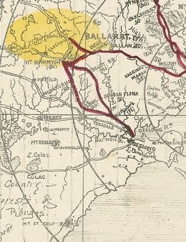
"Map of Port Phillip from the survey of Mr Wedge and others" 1836. This
image from the National Library of Australia produced from the work of the
surveyor John Helder Wedge gives an indication of the existing tracks around
the You Yangs and the extent to which the country was known at that time
From Point Henry, they headed to Dr Alexander Thomson's property 'Kardinia' on the south bank of the Barwon, however owing to an injury to his ankle, Sinclair was forced to turn back. Gellibrand and Hesse continued on to Pollock's, further up the Barwon where they obtained a guide, named variously as Akers, Akehurst or Aikers according to different sources. From Pollock's station, the party of three followed the Barwon with the intention of crossing the river at its confluence with the Leigh River and then following the latter upstream probably to George Russell's then outpost at today's Shelford. From there, they planned on returning east behind the You Yangs to the Exe (Werribee) River where both Gellibrand and Captain Swanston held land. As they only intended that their journey would be a short one, they carried very little in the way of provisions and equipment.
The confluence of the Barwon and Leigh Rivers today is a clear t-junction with high water levels and it is hard to imagine how a mistake was made, but this was prior to the construction of the various dams and weirs or the advent of water licences which today affect the flow of both rivers. In 1837 there clearly was not much to distinguish between the Leigh and the various other creeks which enter the Barwon from the north and so the party continued upriver throughout the day, despite Akers' protestations that they had missed the crossing point which they had expected to find around nine miles upstream of Pollock's station.
The confluence of the Leigh and Barwon Rivers at Inverleigh, 2017. In this
photo the Leigh flows from the left and the Barwon from the right and the
combined streams flow away from the camera towards Geelong
Instead, having travelled around 35 miles, the party camped for the night on the banks of the Barwon and the following morning, refusing to go further, Akers turned back, reaching Pollock's station the next day. Hesse it seems also shared some of Akers' concerns, but these were dismissed by Gellibrand who by that time was convinced that the Warrion Hills which lie to the north west of Lake Colac were instead, the You Yangs (George Thomas Lloyd, Thrity-Three Years in Tasmania and Victoria, Being the Actual Experience of the Author Interspersed with Historic Jottings, Etc, Houlston and Wright, 1862, pp 485-486). This was not the first time that Gellibrand had expressed a confidence in his own knowledge and abilities which proved unfounded. In The narrative of George Russell of Golf hill, with Russellania and selected papers (Russell George (1812-1888) and Brown, Phillip L, 1935) Russell claimed that "he [Gellibrand] was under the impression that he knew a great deal of the country and of the names of the different landmarks in the neighbourhood of Geelong". Subsequent conversation revealed to Russell that this was not the case.
This 1858 sketch by Eugene von Guerard shows the Warrion Hills which
Gellibrand most likely mistook for the You Yangs. Image held by the
National Gallery of Victoria
Despite Akers' untimely return, it was around a fortnight before those at Geelong who were in a position to help, learned of the non-arrival of Gellibrand and Hesse at their intended destination. At that point a mounted search party consisting of Captain Pollock, John Cowie, David Stead, Thomas Roadknight and Thomas Armytage along with Akers set off to begin the search. Their first day's travel saw them reach the point at which Akers turned back, after which they followed the tracks of Gellibrand and Hesse a further four miles upriver before their path turned westward across a plain, finally losing all trace of them about 50 miles from their starting point at Pollock's. After searching the surrounding area for a further day, they returned empty-handed. Not long after, on the 31st March, a second search party which included Gellibrand's son Thomas, the escaped convict William Buckley and two members of the local Wathaurong tribe set out (Launceston Advertiser, 13th April, 1837) but they also returned, unsuccessful.
By April, reports had begun to circulate that the missing men had been killed by "natives" (The Sydney Gazette and New South Wales Advertiser, 25th April, 1837), that they had been murdered and the bodies found (The Sydney Monitor, 19th April, 1837), that Buckley had returned from searching but no trace of either men or horses had been found (The Australian, 25th April, 1837) and so on. On 18th April, a third search party led by Joseph Beazley Naylor and Charles Octavius Parsons, with the backing of the men's families set off for the Lake Colac district, accompanied by native guides and armed with the information that two white men had been killed by Aboriginals in that area.
The above image shows the likely route through the lands of the local indigenous
tribes taken by Gellibrand and Hesse after leaving Point Henry. Image taken from
Donovan, Paul Michael F, Clark, Ian D and Cahir, Fred , 'The remarkable
disappearance of Messrs Gellibrand and Hesse'. What really happened in 1837?:
a re-examination of the historical evidence
, Victorian Historical Journal, Vol. 87,
No. 2, Dec 2016: 278-297
At this point, inter-tribal politics came into play when two members of the Lake Colac Guldijin Tribe were murdered by armed members of the Wathaurong Tribe from the Winchelsea area who had joined the search party and were known to be in conflict with the former. The Wathaurong tribesmen captured a Guldijin tribesman by the name of Tanapia  on the shores of Lake Colac from whom, they claimed to have extracted a "confession" for the killings. The bodies it was claimed, had been disposed of in a lake. Upon receiving this information the search party returned to Geelong (Rogers, Thomas, 'Friendly' and 'hostile' Aboriginal clans: the search for Gellibrand and Hesse, History Australia, (2016),Vol. 13, Iss. 2, pp 275-285). Tanapia was later found to be innocent of murder, however he did admit to having speared the horses and other members of the tribe were found with some of the men's belongings.
And there perhaps, things rested until 10th July, 1844 when the Geelong Advertiser published the recollections of a squatter by the name of Henry Allan who - along with his brother - had settled on the Hopkins River. Allan claimed that a group of natives had shown him the location of a grave near Moonlight Heads a few months earlier. The description of the man fitted that of Gellibrand and the tribe claimed that he had lived with them for around two months after stumbling upon them, starving and exhausted, saying that his companion had died about 20 miles further upriver. Their horses it was presumed had been turned loose as they entered the thick bush some 20 miles or more to the north where presumably they were then found wandering by the Guldijin tribe of Tanapia.
This image of logging in the Otways during the 1890s shows how heavily
wooded was the forest to the south of Lake Colac through which Gellibrand
and Hesse struggled. Image from a collection of lantern slides by Roger
Holdsworth, image held by the State Library of Victoria
A similar article published in The Dispatch on 27th July, 1844 (taken from the Port Phillip Herald) gave a corroborative statement provided by John Allan, brother of Henry in which he claimed that an indigenous woman married to a tribesman who lived near the Allans remembered the killing of Gellibrand which had been perpetrated by members of a rival clan which lived a few miles to the east of Cape Otway. He sought the woman out, heard her story and arranged for Henry to travel to the site
where he exhumed the body and took with him the skull and and some personal effects which had also been buried. The general location of Hesse's body was indicated but the weather did not at that time permit travelling to the site. The same information, along with the opinion of a medical practitioner was sent in a letter to Captain Foster Fyans. The letter and details of the report were published in the Geelong Advertiser, 24th June, 1844 and as far as the Advertiser was concerned, solved the mystery of what had become of Gellibrand and Hesse.
Then in 1846, whilst on his third expedition attempting to reach Cape Otway (Clark, Ian D., Scars in the landscape: a register of massacre sites in Western Victoria 1803-1859, Canberra Aboriginal Studies Press for the Australian Institute of Aboriginal and Torres Strait Islander Studies, 1995) Lieutenant-Governor La Trobe noted that the Allans showed him what they believed to be the burial sites of Gellibrand and Hesse (Donovan et al., 'The remarkable disappearance of Messrs Gellibrand and Hesse'. What really happened in 1837?a re-examination of the historical evidence, Victorian Historical Journal, Vol. 87, No. 2, Dec 2016: 278-297).
This however, was far from the end of the story. For about three years following Allan's discovery, the skull is said to have hung from the roof of his hut (The Colonial Times, 25th August, 1846) and it was not until that time that it was sent to Tasmania for further examination. Furthermore but somewhat at odds with this account is another, earlier description given by a traveller who met the Allans in September, 1839 and claimed that he was shown a skull with fractures - supposed to be from a tomahawk - which they believed to be that of one of the missing explorers (The Austral-Asiatic Review, Tasmanian and Australian Advertiser, 8th October, 1839).
In The Argus of 13th November, 1909 Donald Macdonald published several letters he had received all purporting to give some information on the fate of Gellibrand and Hesse. Mrs Jones indicated that she was shown a box containing Gellibrand's body during a visit to the Allans in 1846 whilst George Somerville recalls hearing that Joseph Gellibrand's son had arrived from Tasmania in 1847 and with the assistance of Allan and the local indigenous tribe had located the body which he was taking back to Tasmania.
And from there, things continue to get muddier, with differing reports of bodies being shipped to Tasmania or remaining some time with the Allans and with some even claiming that numerous skulls were sent for examination with no conclusive proof being found. Of course, Gellibrand and Hesse were not the only white settlers to have disappeared in the area over the years so it is not unlikely that other Caucasian skulls may have been discovered in the district.
It would seem however that by the end of 1837 it was generally accepted that the pair had perished as on 27th November notice was given of the intent to apply for probate of George's will in the Supreme Court (The Austral-Asiatic Review, Tasmanian and Australian Advertiser, 12th December, 1837). Things were a little more difficult in the case of Gellibrand whose life was the subject of an £10,000 insurance policy - the first in Australia it is claimed according to Asteron Life (formerly Alliance Assurance). It was also the first life insurance policy paid out - albeit after a three year wait as no proof of death was available. The payment was eventually made however, to Gellibrand's widow Isabella.
A mahogany and rosewood writing case belonging to Joseph Tice
Gellibrand. Item and photo from the Joseph Tice Gellibrand Collection,
National Museum of Australia
So, despite or perhaps because of the many claims to have found the remains of the two men in the years following their disappearance, the general impression developed that Gellibrand and Hesse vanished without trace and their bodies were never found. Whether deliberately or not, various researchers have contributed to this impression and in the process created one of the most enduring legends of the 19th century Victoria.
One such was Isaac Hebb who, styling himself as IZAAK, in November, 1888 wrote an account of the disappearance of Gellibrand and Hesse which appeared in consecutive editions of the Colac Herald. Dramatically titled "ROMANCE OF THE OTWAY--MYSTERIOUS DISAPPEARANCE OF MESSRS GELLIBRAND AND HESSE", it made the claim that no reliable evidence existed that the bodies were ever found, however more recently, there have been scholarly articles which cast the events surrounding the disappearance in a different light, particularly with respect to the role played by the various indigenous tribes of the region, whose oral testimony was of course not considered admissible evidence (Rogers, Thomas, 'Friendly' and 'hostile' Aboriginal clans: the search for Gellibrand and Hesse, History Australia, (2016),Vol. 13, Iss. 2, pp 275-285). Likewise, Donovan et al., 'The remarkable disappearance of Messrs Gellibrand and Hesse'. What really happened in 1837?a re-examination of the historical evidence, Victorian Historical Journal, Vol. 87, No. 2, Dec 2016: 278-297 re-examines the available sources through modern eyes, concluding that there is significant evidence to suggest that the mystery of Gellibrand and Hesse is not as much of a mystery as we have been led to believe.
Hesse St, Queenscliff, January, 2018
Whilst most may not realise it today, there are still many reminders of this episode in Victoria's colonial past, from the towns of Gellibrand and Gellibrand Lower; the Gellibrand River which rises in the Otway Ranges near the Barwon River, flowing west and south where the Barwon flows north and east; Mounts Gellibrand and Hesse on the plains west of the Barwon between Inverleigh and Winchelsea and the 19th century squatting runs of the same names which surrounded them; the town of Hesse; the Australian Electoral Division of Gellibrand incorporating many of the western suburbs of Melbourne; Point Gellibrand at Williamstown where the earliest European settlers landed their sheep and the associated Fort Gellibrand; to numerous Hesse and Gellibrand Streets including those in Colac and the coastal town of Queenscliff. The men themselves may be long gone, but their names live on.

30 July, 2017

Fred Kruger

From the earliest days of European settlement, artists recorded the environment in which they found themselves and often their sketches, paintings and later photographs included the creeks and river systems of the regions they visited or in which they lived. This was also true of the Barwon River catchment. In the earliest days of settlement, artists such as George Alexander Gilbert, Samuel Thomas Gill, Charles Norton, Louis Buvelot, Eugene von Guerard and a host of others, recorded their surroundings and in the process created some of the region's best known artworks.
By 1879, a noted landscape photographer by the name of Fred Kruger had established himself in Skene St, Newtown and was rapidly becoming known about Geelong. In November he was invited to photograph the opening of the new Corio Bay Rowing Club boat shed, located near the Yarra Street Pier (Geelong Advertiser, 29th November, 1879). The following month, he was commissioned to photograph both the exhibits and the building when the newly-erected Geelong Exhibition Building hosted an Industrial and Juvenile Exhibition, boasting some 30,000 exhibits.
Geelong Exhibition Building, Fred Kruger (1882), Image held by the
State Library of Victoria
Over the course of the next eight years, Kruger contributed greatly to the photographic record not only of Geelong, but the entire region, including the Barwon, Leigh and Moorabool Rivers. So who was Fred Kruger?
 Johan Friedrich Carl Kruger was born in Berlin, Germany on 18th April, 1831 to a working-class family and as a young man, went into business as an upholsterer. By April, 1863 when his wife Auguste Wilhelmine Elisabeth Bauman and their three year old son Hans arrived in Victoria on the ship Macassar, Kruger had already settled in Rutherglen where he was a partner in his brother's furniture business which had operated since 1854. Soon after their arrival, a daughter was born to the couple and Kruger became the sole owner of the business which he sold before moving to Taradale where he established himself as a cabinet maker.
The births of two sons were registered at Taradale in 1866 and 1867 but the family did not remain long in the area, instead moving to Melbourne where Fred established a photography business in Carlton, later moving to Prahran then Preston. He soon developed a reputation as a landscape photographer, winning awards both internationally and in Australia as well as receiving acclaim for his photos of indigenous Australians.
Auguste and Fred went on to have a further six children, all born in Melbourne however at least five of their nine Australian-born children died as infants in their first year of life. Then, some time during the late 1870s or early 1880s Kruger and his remaining family moved to Geelong where they lived in Skene St, Newtown.
During his time in Geelong he took numerous photos of local scenes, travelling also to surrounding towns including Queenscliff, Point Lonsdale, Ballarat, Werribee, Winchelsea, the Otways and many places in between.
The Leigh River, near Inverleigh, Fred Kruger, 1882. Image held by the State
Library of Victoria
In order to make a living, Kruger accepted commissioned work both from the government and local landowners who wanted a visual record of their estate. He is also known to have taken photos of the Barwon in flood as well as shipwrecks off the coast at Point Lonsdale, as images of such events were popular with the buying public.
Kruger's 1881 Photograph of the paper mill at Fyansford. Image held by the
National Gallery of Victoria
I suspect, but do not know, that Kruger's photo of the paper mill may have been taken not long after extensive flooding hit the region. Kruger's photo above shows the ana-branch which connects the Barwon (left) to the Moorabool (right) a short distance above the confluence of the two rivers. Between the river and below the ana-branch is the almost completely denuded Redgum Island. In my image below, the course of the now tree-lined ana-branch runs through the middle of the shot with the lines of the rivers just visible to either side as an indentation in the trees.
A similar view of the paper mill taken May, 2016. At the time, I had no idea
I was standing so close to the spot where Kruger stood some 135 years
ago to take his photograph
In addition to a number of photographs taken near Batesford and the now non-existent town of Viaduct on the lower reaches of the Moorabool, Kruger also visited both Lal Lal Falls and the nearby Moorabool Falls in 1882, perhaps on his way to Ballarat.
The Moorabool Falls on the Moorabool River near Lal Lal, as seen by Kruger
in 1882. Image held by the State Library of Victoria
Moorabool Falls, April, 2012
On the 15th February, 1888, after contracting peritonitis, Fred died at the home of his son in the Melbourne suburb of Surrey Hills. His wife Auguste lived a further 25 years, dying at Preston in 1913. Over the years, his photographs have remained popular and as recently as 2012, the National Gallery of Victoria who hold a large number of his photographs, hosted the "Fred Kruger: intimate landscapes" exhibition. An earlier exhibition was held in 1983. Many of his works can also be found in digital format across the Internet.


18 September, 2016

...and up they rise!

By Friday 9th September, 2016 a large rain band was moving across Victoria and over the next several days, heavy rains hit the Barwon Catchment. River levels began to rise and by early Wednesday morning the Upper Barwon was in flood as was the Leigh River at Shelford. By Wednesday evening the combined floodwaters from the Upper Barwon, the Leigh and Moorabool Rivers reached Geelong. With the rising water levels came the usual increased interest in the Barwon.
So, before all the excitement of the past few days dies down and the river heights return to more normal levels, it is probably worth posting a few flood photos for posterity as I have done during other flooding events on the Barwon. I won't go into too many facts and figures as I have done that previously. For those interested this post from September, 2011 looks a little at the causes of flooding on the Barwon.
For comparison purposes, here is the post from a small flood event in August, 2012 and this from the January, 2011 flood which always proves remarkably popular when river levels rise.
The current flood event by comparison reached "moderate" levels on both the Upper and Lower Barwon as well as on the Leigh River at Shelford which peaked mid-afternoon on Wednesday at a height of 7.22m. Through Geelong, the flood level peaked over night Thursday at a height of 3.29m, having earlier reached a peak of 6.13m on the Upper Barwon at Rickett's Marsh at around 5:30pm Wednesday.
Moorabool River
Batesford, 8:15am 15th September, 2016


Fyansford, 9:45am 15th September, 2016

Fyansford, 2:30pm 15th September, 2016

Leigh River

Inverleigh, 9am 15th September, 2016


Barwon River

Pollocksford 8:45am 15th September, 2016


  Baum's Weir, 9:45am 15th September, 2016

Buckley Falls, 4:30pm 16th September, 2016


 Fyansford Paper Mill, 1:45pm 15th September, 2016


Newtown Lookout, 4:45pm 15th September, 2016 

Queen's Park, 4:45pm 16th September, 2016


Balyang Sanctuary, 4pm 16th September, 2016


Barwon Bridge, Geelong 5:15pm 15th September, 2016


Breakwater, 3:45pm 16th September, 2016

Lake Connewarre, 12:15pm 16th September, 2016

Barwon Heads, 12:45pm 16th September, 2016

 Barwon Heads, 1pm 16th september, 2016

 Barwon Heads Bluff, 3pm 16th September, 2016


 For now, the rain has - mostly - abated, the floodwaters are receding and the clean up will soon begin, however on a saturated catchment with more than two months of spring rain still to come it remains to be seen what will happen next...
Further photos at each of the above locations can be seen at the following link: the rivers in flood, 2016


22 May, 2016

Mapping the Barwon Catchment

Before the arrival of John Batman and his party on the shores of Port Phillip Bay in 1835, the indigenous tribes of the Barwon catchment walked the land, following traditional "songlines" which had evolved over thousands of years. The songs and stories of the many tribes, described the land and the physical pathways they used to cross the countryside, enabling them to navigate long distances, passing safely through unfamiliar territory. I discussed songlines in my previous post.
Europeans on the other hand, saw the land very differently to the indigenous population and used very different navigation techniques. The Europeans too used maps, however they drew their maps on paper, measured distance, calculated elevations and aligned everything according to compass bearings. And they way they travelled was vastly different too. Whilst many still walked, others rode horses and drove bullock drays and it wasn't long before the paths of the songlines became the bullock tracks of the squatters. They in turn were followed by the surveyors with their chains and newfangled theodolites who marked out the roads of the selectors and villagers.
The settlers were also quick to start applying their own mapping techniques to their new surroundings. The squatter's runs were plotted out and the bullock tracks which linked them with the towns which began to pop up, were marked as vague wavy lines.
Section of Surveyor Alexander Skene's 1845 map of the Geelong District
showing early tracks and the names of squatters and early landholders
across the catchment. Original image held by the State Library of Victoria
The more the number of settlers increased however, and the more they extended the boundaries of their settled districts, the more maps were created. Not only did these maps indicate direction and location, but there were also administrative maps, electoral maps, geological maps, maps which indicated individual land ownership (an unfamiliar concept to the indigenous peoples), weather maps and many other types of maps besides. Soon the entire colony had been layered with maps and amongst the earliest of these maps were survey maps.
In order to better administer the vast areas of the new colony, the land was formally divided for the purpose of administering the sale and distribution of land. From the late 1840s until the 1890s, the government progressively undertook a comprehensive survey of the  Colony of Victoria, reclaiming the squatters' leaseholds and breaking up the thousands of acres into village allotments and farm-sized blocks. To aid administration, county boundaries were established and within each county the land was subdivided into civil parishes.
Portion of the Victorian Counties Atlas, 1874, showing those counties which fall
within the Barwon Catchment. Image taken from the State Library of Victoria
Initially, the county boundaries were by necessity ill-defined and changed according to need. The following description from the Geelong Advertiser 17th July, 1841, claiming to give the first official description of Grant County's limits, shows both how they changed over time and - like the Wathaurong whose lands it covered - how the new settlers also used the natural landscape to define boundaries.
The Coast Line from the mouth of the Werriby(sic), Port Phillip, round to a point bearing south of the sources of the Barwon [Barwon Heads]. An imaginary line from that point to the sources of the Barwon [the Otways]. the Barwon from its sources to its junction with the Native Hut Creek. The Native Hut Creek from that junction to the Buninyong and Melbourne road(sic). The line of that road to the Werriby, and The Werriby River to its mouth.
By 1871, the 37 Victorian counties as we know them today were in place. Counties and their accompanying civil parishes were - and still are - used entirely for real estate purposes, enabling the physical description of a piece of land.
Section of 1881 Victorian civil parishes map. Original image held by the
State Library of Victoria
With European settlement came the English system of government. Having been declared a separate colony from New South Wales on 1st July, 1851, Victoria needed to put a government in place, however it was not quite the system we have today. The original Victorian parliament was unicameral - having only one house. Called the Legislative Council, it was composed of 16 electoral districts from which 30 members were chosen. Ten were nominated by the Lieutenant-Governor and 20 were elected from the eligible voting population. To be eligible to vote a person had to be a male British citizen over the age of 21 who paid more than £10 per annum in rent or held the freehold for property valued at more than £100. Once again the colony was mapped and divided. This time for electoral purposes. The Wikipedia map below shows the original electoral districts and I have indicated the general area of the Barwon catchment within the black box.
Electoral districts of the original Victorian Legislative Council, 1851.
Original image from Wikipedia
Within a handful of years however, electoral boundaries were being shuffled and in 1856 a second or lower house - the Legislative Assembly - was introduced, resulting in the system we have today.
State electoral districts for both the upper and lower houses of the Victorian parliament have continued to change in response to the growing population. Today there are 88 electoral districts, each corresponding to a seat in the Legislative Assembly. These are combined into eight districts from which five Legislative Council members are elected, giving a total of 40 members in the upper house.
Current boundaries of the state electoral districts (lower house) which
cover the Barwon catchment. Original image from Wikipedia
In 1901, the cartographic landscape of the Barwon catchment changed once again with the advent of Federation. The Colony of Victoria became the State of Victoria and was divided for the purpose of voting into federal electoral divisions. These were (and still are) different to the electoral districts of the state government. The electorates of Corangamite, Ballarat and Corio are all, at least in part, within the catchment.
Federal seats within the Barwon catchment. Original image from Wikipedia
Of course, beneath the federal and state levels of government is local government. In the 19th century, local government stemmed from the need to raise funds for roads and infrastructure, consequently a series of "road districts" were gazetted across the colony. Within a few years, the road districts were transformed into shires which along with cities and boroughs today make up the various municipal districts of the local government system. Not surprisingly, as with state and federal electorates as well as county and parish boundaries, the banks of the creeks and rivers of the Barwon catchment often formed the boundaries of these early shires too. Also in keeping with other levels of government, the number of municipal districts has changed over the years. For instance, in 1915, the Shire of Meredith was amalgamated with that of Bannockburn.
Country Roads Board map, 1961 showing parish boundaries. Original image held by the
State Library of Victoria
In 1994, sweeping changes saw the amalgamation of many smaller shires and city councils in to a lesser number of much larger shires and cities. Where before the catchment contained perhaps as many as many as 15 shires and cities, after the amalgamations, this number fell to around six.
The outbreak of the Victorian gold rush in August, 1851 also saw a flurry of map making. Every digger wanted to know the best route to get to the diggings. As I have written before, there were claims, counter claims, insults and outright lies hurled back and forth between parties with vested interests in promoting their route to the diggings. Maps could not only be used to inform the general public (as below), but also to deceive as Geelong discovered when interests in Melbourne published a "false map".
The relevant section of a reasonably accurate "Digger's road guide to the gold mines of
Victoria and the country extending 210 miles around Melbourne", 1853. Image taken from
the National Library of Australia
 As well as the topography of the land and the roads and tracks which crossed it, the gold rush led to an intense interest in what lay under the surface of the soil. In 1852 Alfred Selwyn was appointed as Mineral Surveyor for the Geological Survey of Victoria and with one assistant and a tent-keeper, set about completing a comprehensive geological survey of the colony. Soil types were assessed, rock deposits dated and the potential presence of minerals noted. Over the years, the department expanded and exists today under the portfolio of the Department of Energy and Earth Resources in the Department of Economic Development, Jobs, Transport and Resources.
Adaption of the 1909 Geological Survey Map of Victoria. Image held by the
State Library of Victoria
Finally, another topic which has always been of particular interest to those living in the Barwon catchment. Rainfall. How much? How little? When? Where? Once again, the indigenous tribes had intimate knowledge of seasonal changes in climate and climate-dependent resources. The European settlers were equally as interested. They needed to know when to plant their crops and where to find water for their stock in different seasons.
Meteorological recording began in Melbourne as early as 1840 and regular, coordinated data collection began in 1854 with the establishment of the Victorian Meteorological Office. The first official report of rainfall data (I could locate) for Geelong appeared in the Victorian Government Gazette dated 21st August, 1857 for the April-June quarter of that year, although references were made elsewhere to earlier data.
Today, rainfall measurements are taken at various points across the Barwon catchment, including Weeaproinah in the Otways, near the headwaters of the Barwon River which has the highest average rainfall in the state. By contrast, the lowlands along the lower reaches of the Barwon, Leigh and Moorabool Rivers lie in the rain shadow cast by the Otway Ranges and receive a significantly lower annual rainfall.
Overview of long term rainfall averages for the Barwon catchment. Graph taken
from the Australian Bureau of Meteorology
Over the years since European settlement, many maps have been produced for many different reasons, dividing the catchment in a multitude of ways. Maps to direct. Maps to divide. Maps to quantify. Maps to persuade, even maps to deceive...