Showing posts with label Sutherland's Creek. Show all posts

04 April, 2016

Making tracks: the Colonel and the one-armed shepherd

With the advent of the gold rush in 1851, diggers flocked to the goldfields of Ballarat and surrounds. In previous posts I followed their path from Geelong via the Geelong-Buninyong Rd and the track from The Leigh (Shelford) to Buninyong. In addition to these routes, there was also a third option, one which a hopeful real estate agent in the Geelong Advertiser and Intelligencer of 13th October, 1853 claimed was "the best line of road to Ballarat, Canadian Gully, Jeweller's Flat & c".
The road in question lay to the east of the Geelong to Buninyong Track, following a similar line to today's Steiglitz Road. After cresting Bell Post Hill, the route led towards Batesford, but instead of following the main road down into the Moorabool Valley, those wishing to take the other road to the east, took the track towards Steiglitz. Other than the above advertisement however, there is little mention of the route before October, 1855 when Steiglitz became a significant destination of its own. According to the Geelong Advertiser and Intelligencer of 16th October, 1855:
The shortest road from Geelong [to the new goldfield at Steiglitz] is to pass Colonel Kelsall's Station, cross Sutherland's Creek, follow the well defined dray road to the left of the creek till you come to the old shepherd's hut, when you are within two and a half miles from the diggings, which are situated on a point or tongue of land between Sutherland's Creek and a tributary creek flowing from the Anakies.
Sounds simple enough, but who were the Colonel and the shepherd?
The colonel was Roger Kelsall, engineer, sailor and then squatter who, according to fellow squatter Thomas Manifold, arrived in the district in the spring of 1836 and took up land on the upper parts of Sutherland's Creek. Prior to his arrival, Kelsall served as Clerk of Works at Port Arthur and was responsible for the design and construction of several of the buildings there. It was not however, until 1845 that he sold his commission with the Royal Navy and retired to Victoria. During this time I believe his run on Sutherland's Creek was maintained for him by a manager named Sharp.
The grave of Colonel Roger Kelsall, his wife Ann and son Roger
at the Eastern Cemetery
 By December, 1854, Kelsall had converted part of his lease into 1,490.5 acres of purchased land - including his pre-emptive right of 640 acres. The latter lay nestled between the left and right branches of Sutherland's Creek down to their confluence, with the rest of the land in several blocks on either side of both branches branch. He gave this property the name 'Chesterdale'. Additionally, the Colonel also purchased 557 acres of land lower down Sutherland's Creek on the west bank, directly opposite the Hope's land. This property, 'Strathey', eventually extended to 1,100 acres by the time both properties were subdivided and sold in 1908. Until that point, they had remained in the hands of the Kelsall family, however not long after the death of the Colonel in 1861, they were leased out to local graziers.
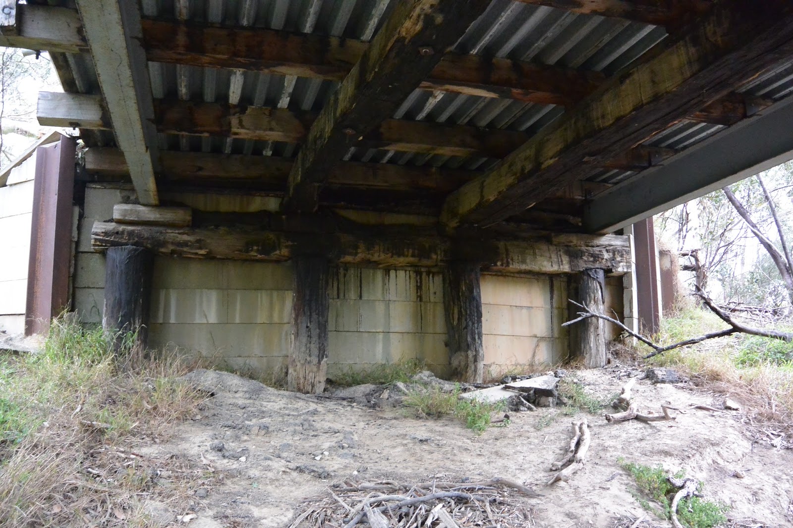
Contrary to the above description of the route, a look at the survey maps shows that the diggers would first have crossed first through the Hope's 'Darriwill' property before crossing the creek onto Colonel Kelsall's 'Strathey' and joining the bullock track. The creek crossing was presumably near the site of today's Hope's Bridge on the Steiglitz Rd. Clearly, the current bridge is not the original, that bridge stood slightly upstream of the modern one. The concrete and bluestone buttresses of the old bridge and various related timbers can still be seen just north of the existing bridge.
Looking upstream at the abutments and some remaining timber and concrete
at the site of the original Hope's Bridge
The earliest mention I can find of a bridge at this site is 1863, when drains were installed on the nearby road. In 1865 when the decking timbers were being replaced, it was discovered that the timbers beneath were rotten and in need of attention, indicating that the bridge had probably been in existence for some years at that time. Other timber bridges I have researched seem to have had a lifespan of around 10 years before structural timbers needed replacing, which might indicate that the bridge dated back to the 1850s. As far as I can tell, two bridges were erected on the Steiglitz Rd. One in 1857 and one in 1858. The latter was on the "Approach to Steiglitz gold-field" so perhaps this was the erection of the Five Mile Bridge, much closer to Steiglitz, whilst the bridge built in 1857 was at the crossing between Hope's and Kelsall's - but that is speculation. Whether an earlier structure such as a ford existed at the site, I don't know.
Looking east across Sutherland's Creek and the original Hope's Bridge
towards 'Darriwill'
After crossing the creek and making their way through Colonel Kelsall's property, it was - according to the above article - a simple matter of following the dray road on the left of Sutherland's Creek, towards the diggings. Other than the above reference however, I can find no mention of a road to Steiglitz before November, 1855, but presumably the dray track mentioned, led originally to the Durdidwarrah squatting run of Charles Augustus Stieglitz.
Another description of the trip to the new goldfield at Steiglitz which appeared a few months later in the Geelong Advertiser and Intelligencer, 28th January, 1856, was perhaps not quite so flattering, but provided a little more detail about the route:
"the road from Geelong to Steiglitz leads, for the first ten miles, through an open and slightly undulating country, the aspect of which is, of course, monotonius(sic) enough. Passing this space you arrive at Sutherland's Creek, now a chain of waterholes not particularly limpid. Next comes a tract of thinly timbered land, terminating in an open piece of rising ground known as the Bald Hill. Beyond this point and within eight miles of the "diggings," you pass in a close succession three refreshment tents, recently pitched, and a weatherboard establishment of a similar character not yet completed. A mile or two further on you find yourself suddenly in the gold country. The rapidity of the transition here is very remarkable. The easy undulations of the soil which prevail in the early portions of the journey give place at once to short and abrupt hillocks, pretty well timbered, and sprinkled over with great quantities of grass...
Being summer, it seems that there was little water in the creek. I can find no other mention of the "Bald Hill", however from context would expect it to be somewhere near what would (by 1856) become the township of Maude. At this point it is also worth remembering the "Buninyong Road from Melbourne" - described in my post "All Roads Lead to the Green Tent" - which intersected the Geelong to Buninyong Track at the Green Tent. This east-west track dating back to the 1840s, also crossed the track to Steiglitz, probably at Thompson Rd, Maude, as evidenced by an 1857 survey map which marks this road as "towards Melbourne". For those not wanting to make the steep climb in and out of the Moorabool Valley at this point, the Steiglitz route provided an alternative for those travelling from Melbourne.
From November, 1855 however, Steiglitz itself became a destination with the discovery of extensive gold reefs, making the track from Geelong even more popular.
Remaining brickwork footings of the United Albion Mine, Steiglitz
Not surprisingly, the sudden increase in traffic heading up the Steiglitz dray road resulted in the establishment of a "close succession of refreshment tents". They were probably similar to those which sprang up on the Geelong-Buninyong Track in the earliest days of the gold rush to Ballarat.
As far as I am aware, prior to the rush to Steiglitz there was no public house between Batesford and these new diggings.
Within a very short time however, that changed. In addition to the "coffee tents", an array of traders scrambled to set up shop in Steiglitz. According to the Geelong Advertiser and Intelligencer, by the first week of January, 1856, tents and stores were popping up by the dozen. As well as the essential butchers, bakers and general stores, hotels were quickly established. Upcoming applications for new liquor licenses advertised in February, 1856 included five for Steiglitz and a further two for Sutherland's Creek, all no doubt capitalising on on the traffic heading up the dray track to the goldfield.
Once past the "coffee tents" as noted, the terrain changed and became more rugged, signalling the presence of auriferous ground. From the turn off to Melbourne, the track fell away, down to a second crossing of Sutherland's Creek, this time at Five Mile Bridge and it was here, several newspaper accounts indicated, that the "one-armed shepherd's hut" could be found. Various reports shared around the colony, stated that a gold reef had been struck near the one-armed shepherd's hut, after crossing Sutherland's Creek, about 20 miles from Geelong.
The bed of Sutherland's Creek. During the 1850s numerous gold mines
operated along the banks of the creek
But who was the one-armed shepherd? Well, despite my best efforts, I have not been able to discover a name. In addition to his hut being a common point of reference on the road to Steiglitz, it was reported that on 21st January, 1856 he was the victim of a robbery, when three armed men known to be from the nearby diggings invaded his hut. Neither his name, nor indeed his presence at the time of the robbery, were not mentioned.
Once past the shepherd's hut, it was only a matter of a few more miles to Steiglitz, if that was the digger's intended destination; and for many, from October, 1855 it was. By December that year, a coach was running from Geelong to Steiglitz, carrying those who could afford it. In fact, within a short space of time, Steiglitz became a staging post for the coaches running to and from Geelong and the goldfields.
The view down Regent St towards the site of Cobb & Co.'s
staging post (left), April, 2010
But Steiglitz was not the end of the journey for every digger. Indeed, prior to October, 1855 it was just another creek crossing on the way to Buninyong, and later, Ballarat. It was also roughly the half way point on this eastern path to the diggings and according to some, was crying out for a public house; a stopping point along the road, where the drays carrying supplies to the goldfields of Ballarat and Buninyong and a little later to places such as Mt Wallace, Mt Egerton, Dolly's Creek and Morrisons, could spend the night or break their journey with a meal.
That need was filled in April 1853, when Richard Coombs announced that he had purchased the mansion until recently owned by Charles Von Stieglitz and converted it for use as an hotel...

24 March, 2016

Branching out: 'Darriwill'

Before I look at the third route from Geelong to the goldfields of Ballarat and beyond, I think it might be helpful to look at a little of the history of some of the properties through which the track passed. This route ran via Steiglitz, but for the first few miles of their journey, those following it would have used the same road up Bell Post Hill, towards Batesford used by those following the Geelong to Buninyong Track.
Before descending into the Moorabool Valley however, they took the turn off for Steiglitz, which led them over Sutherland's Creek and onto the high ground between the creek to their east and the Moorabool Valley further to the west.
In the earliest days of European settlement the land either side of the Moorabool river below Sutherland's Creek down to Fyansford was occupied by the Manifold brothers. Above the confluence of Sutherland's Creek with the Moorabool, the land was occupied by Joseph Sutherland. According to fellow squatter Thomas Manifold, Sutherland took up the land in 1836. Joseph was a Scotsman and amongst the earliest settlers in the Port Phillip District. The only other information I have been able to discover, indicates that he was on his Sutherland's Creek Run at least during 1842-1843, but soon moved on to more distant pastures.
By 1846 three brothers - Robert Culbertson, George and James Hope - who had travelled overland from New South Wales began to lease and purchase large tracts of what had been the Sutherland's Creek Run of Joseph Sutherland and some of the land occupied by the Manifolds. In June, 1846 George purchased 734 acres of land along the Moorabool River at Batesford and according to deeds dated November 1847, Robert purchased almost 2,000 acres of land to the north along either side of Sutherland's Creek. Further, in September, 1848, James and George were granted a licence to depasture stock in the same area on the Moorabool.
The Moorabool River at Baker's Bridge in 2011. The river at this point formed
part of the boundary of 'Darriwill'
In April, 1849 Robert was granted the lease of around 2,000 acres under pre-emptive right in the parishes of Darriwill and Yowang and by 1850 his application to lease land had increased to include 8,720 acres in the parish of Yowang - presumably in addition to his freehold land. As well as his pastoral pursuits, Robert was a practising medical doctor and on 21st January, 1848, he was appointed coroner for the District of Geelong. In November, 1856 he was returned as one of five members representing the South Western Province in the Legislative Council of Victoria, holding office until August, 1864. In April, 1867 he was again elected to the same seat, holding office until 1874. During his time in parliament he was known for his very conservative views. A staunch advocate for the rights of the landed classes, he fought fervently against any move to limit their privileges or to allow selectors the right to choose land already leased from the crown by the squatters.
By contrast, brother George appears to have concentrated more on establishing the family property. Survey maps show that in 1854 he purchased more land adjoining those blocks bought by Robert in 1847, bringing the total freehold owned by the Hopes to over 4,000 acres along the east bank of Sutherland's Creek between today's Robbs Rd to the north and Lovely Banks Rd to the south.
Having purchased substantial acreage, the Hopes no doubt felt secure enough to begin building and making permanent improvements to their property which they called 'Darriwill'. In 1856, they built a single-storey, bluestone house to the design of John Young, with later additions - including a cellar - designed by prominent Geelong architect J.L. Shaw (The Stepping Stone: a History of the Shire of Bannockburn, D Beaurepaire, 1995).
'Darriwill', image taken from the Victorian Heritage Database
According to the Victorian Heritage Database, this was the residence of George who established a substantial vineyard on the property in addition to running sheep. Hope's winery was described in a glowing article written by The Age on 7th March, 1864, which also made the surprising observation that the property, in outline, had the appearance of a bat.
1878 survey map of Yowang and Darriwil Parishes overlaid on Google Earth,
with an outline showing the land purchased by the Hopes
By October, 1878 under George's guidance, 'Darriwill' had grown to 4,768 acres. He lived at the property for the remainder of his life, dying on 25th April, 1884 at the age of 69. The property remained in the family, administered as per the terms of George's will by a trust administered by his wife Marianne and eldest son James. Over subsequent years, the names of his sons George Rowland and William Waugh Hope also appeared in connection with the property.
In 1909 however, the majority of the property (3335 acres) was subdivided into 26 lots of varying sizes which were then auctioned off, leaving only around 700 acres of the original land along with the homestead, in the hands of the family. The remaining land and assets continued to be run by a family trust up to and following the death of James (1903) and Marianne (1911). Isabella, the unmarried daughter of George and Marianne, lived at 'Darriwill' until her death in 1939 after which, the property was distributed according to the terms of her will amongst the family. In 1941 however, the original homestead and 700 acres were bought at auction by her nephews - George Rowland's sons - thus retaining the property in the family.
Photos of Marianne and George Hope along with their daughter Isabella. Image
held by the State Library of Victoria
Also in their hands was the neighbouring property 'Darriwill North'. How or exactly when the family took possession of the property, which formed part of the original land purchased by Dr R.C. Hope in 1847, I have not discovered. It was here however, following the death of her husband George Rowland Hope in 1920, that his widow Agnes was responsible for the construction of a second home in 1925. This house, designed by Geelong architects Laird and Buchan, was a single storey, brick building in the Californian Bungalow style commonly constructed between the two World wars. Further extensions were added two years later in 1927. Agnes, lived at the property until her death in 1955.
Photo of 'Darriwill North' taken in 2008 (Stan Lawrence Real Estate Pty Ltd)
'Darriwill North' remained in the Hope family until 2008 when Alistair Hope (great grandson of the original settler) and his wife Ellen, finally sold the property, thus ending nearly 170 years of occupation and ownership by the Hope family at Darriwill. The house remained on around 268 acres of a total 1650 acres sold and in 2011 Darriwill North Holdings Pty Ltd was listed as a private company. 'Darriwill North' is now a registered stud, breeding both Dorper sheep and Kelpie dogs.
By contrast, 'Darriwill', including the original homestead, was only retained by the family until 1971 when, following the death of Rowland Hope on 9th November the previous year, it was sold to Sanford and Jane Nevile who retained the property until 1994.
Looking north along Sutherland's Creek from Hope's Bridge on the Steiglitz Rd.
The land to the right belongs to 'Darriwill North'
 At this time, the property, including 840 acres, was purchased by Dougal and Nellie Ramsay who extensively replanted the garden surrounding the house. The Ramsays also went on to establish the Darriwill Farm chain of retail stores and cafes throughout Victoria, developing the Darriwill name into a highly sought after brand.
In March, 2012 however, 'Darriwill' was once again on the market, advertised as including both a winery and olive grove, incorporating 966 acres of land. It was hoped that the property would fetch in excess of $10 million, however its eventual sale price fell short of this mark.

29 August, 2015

Branching out - the Old Five Mile Bridge

In the earliest days of settlement, establishing reliable river crossings was crucial to the growth and prosperity of the new Colony of Victoria. Initially, fords and breakwaters were established and punts or small boats could be used to ferry passengers across larger rivers. Eventually, bridges were built, however they were expensive to construct and maintain and were always at the mercy of the elements. Economic realities then as now, often meant that the longest-lasting or strongest bridge was not necessarily the one built.
 Wood was cheap and readily available and timber bridges were quick to build. The downside however was that they had an effective lifespan of around ten years before substantial ongoing repair and maintenance was required. Stone was another plentiful building material - especially across the basalt plains through which the rivers of the Barwon catchment run - however it was expensive and time consuming to build in stone. As a result, scores of smaller creek and river crossings made do with fords or timber bridges.
One way to minimise costs was to construct bridges from a combination of building materials. Bluestone abutments were commonly used to support a timber deck - as was the case of the Blue Bridge over the Moorabool River on the Yendon-Egerton Road - or they could be added later to reinforce a crumbling embankment. The latter was the case when repairs to the original timber bridge at the Leigh Grand Junction were required.
There were of course, other factors to consider too. During the summer months, timber bridges were at risk from bushfire and constant exposure to water meant rot was a permanent problem. Stone structures were less likely to be affected by fire and were impervious to water, but all bridges were to a greater or lesser extent susceptible to flood damage. Over the years these factors have resulted in a number of bridges across the Barwon catchment which reflect not only the ravages of age and the environment, but also provide a visual time line of changing construction materials and building techniques as progressive repairs were implemented.
The first example which comes to mind is the Old Five Mile Bridge which crosses Sutherland Creek's west branch on the Steiglitz Road from Geelong. Today, the bridge sits disused and all but unnoticed beside the modern, two-laned Ken Middleton Bridge which now carries all traffic. The old bridge however is a time capsule which represents the evolution of bridge maintenance in the Borough of Steiglitz and the shires of Meredith and Bannockburn.
Sign still in place at the bridge
According to the description given by the Victorian Heritage Database, all of the piers, raker piles (angled beams supporting the piers) and some of the timber stringers (beams running the length of the bridge under the deck) are original. The stringers are showing obvious signs of decay. Other beams are newer replacements. To my untrained eye, the crossheads which sit across the top of the piles look newer and clearly the steel girders are also a later addition, as presumably are the crossbeams which they support. Likewise, the deck which is constructed of steel and concrete topped with bitumen would have replaced original timber. The abutments on either bank are reinforced with what appears to be relatively modern concrete slabs, held in place by steel girders driven into the bank and timber posts. Behind the slabs is more timber and concrete.
View underneath the bridge, looking north which shows the timber stringers
showing signs of decay and the original piles along with the newer steel beams
and deck
The problem however, is knowing which repairs occurred when and what is meant by "original". As far as I can tell, there has been a bridge on the site since 1857 when the Victorian Government Gazette gave contract details for a bridge to be built "over Sutherland's Creek on the road to Steiglitz" or 1858 when Roads and Bridges Office in Melbourne called for tenders for "the construction of a bridge over Sutherland's Creek. Approach to Steiglitz gold-field". In view of the latter comment, perhaps the latter date is most likely whilst the earlier date may refer to Hope's Bridge on the same road near Gheringhap.
 It was re-decked in 1871, again required repair in 1873 and then in 1874 was declared unsafe even for ordinary traffic, but little more is mentioned in the newspapers until the spring of 1880 when the Moorabool River and surrounding waterways experienced the largest flood in recorded history to that date.
Several bridges were described as having been washed away, including the Five Mile Bridge. Naturally, it was necessary to rebuild and it was common practice to cut costs by reusing any salvageable material, although whether this occurred here I do not know. With the rebuild underway, it was discovered in March, 1881 that the new structure was being built on soft, loamy, clay soil and in order to secure it, the bridge would have to be partially dismantled and then reconstructed using a significantly greater amount of timber than originally anticipated. The council considered the issue and called for tenders to either repair the existing structure or build a new one. Ultimately it was decided that the better option was to build a new bridge, however rather than replicate the existing 24 ft bridge, it was decided that the new structure would be 12 ft wide. The contract was eventually awarded to E Kennealey whose tender of £114 was accepted. In addition to completing the job, Kennealey also agreed to purchase some of the used timbers from the previous structure, however the following year, with payment still owing, the council abandoned the agreement.
Looking north along the deck of the old bridge. The new Ken Middleton Bridge
can be seen to the left of the picture
It is perhaps also worth noting that the shire engineer in charge of the project would have been Allan Robinson, a gentleman who had held this position since the earliest days of the Meredith Shire in 1864. During the 1880s however he faced allegations of laxity and carelessness in the completion of his duties. Finally at the insistence of the council, he tendered his resignation in September, 1888.
All this reconstruction however was ultimately for naught. In February, 1883 the creek flooded once more and the bridge was destroyed a second time. By September the shire was again calling for tenders for its reconstruction, indicating that a 66 ft wooden bridge over Sutherland's Creek was required. At this time, engineer Robinson had been given a leave of absence pending a council decision on his continued employment and it was left to the acting (and unqualified) engineer Mr J Murphy to deal with the matter. Murphy appealed to the engineer of neighbouring Leigh Shire - none other than CAC Wilson - to draw up plans for the bridge, however Wilson who was on leave at that time, sent one of his sons (possibly Frederick who later served as shire engineer to Meredith) to take the levels. The younger Wilson upon assessing the situation felt that it would be impossible to sink piles deep enough to stabilise the bridge, as the surrounding rock was too hard and too near the surface.
Section of an 1865 geological survey map showing the bridge site. The area is
composed of Post Pliocene clay, gravel and mud (green) and Silurian rock (grey)
with nearby patches of Miocene clay, gravel, shale and sand (brown). Original
image held by the State Library of Victoria
How this issue was resolved, I cannot discover, however it is certain that the bridge was reconstructed. On this occasion, the contract was awarded to F Lee and the works completed presumably without incident. There was a slight mishap however only a few years later in January, 1886 when a carter who was removing a house from Steiglitz township, clipped the handrail of the bridge causing unspecified damage to this and other parts of the bridge.
The bridge was almost destroyed yet again in 1898. This time however, the threat was fire, not flood. Fortunately, the coach service from Geelong to Steiglitz happened to be passing and the driver noticed smoke billowing from under the deck. He quickly raised the alarm at a neighbouring farm and the fire was extinguished before it could take proper hold of the timber decking. It was supposed that a camper had failed to properly put out a campfire underneath the bridge.
The southern end of the bridge showing the concrete abutments and scorched
timbers. The pile on the right has bitumen on its surface which appears to have
melted and dribbled down from above, but when I cannot tell
 There is little further mention of the bridge until 1902 when it was deemed unsafe for loads of over 1 ton. By 1915 things had reached crisis point and in March, it was decided to petition the government for the cost of a new bridge. The engineer at this time was CCP Wilson. I can find no further reference however to any attempt to secure funding for a new structure and in May, 1916 assessment by Bannockburn Shire Engineer ETM Garlick, revealed that four beams on the western (upriver) side of the bridge were completely rotten. Their replacement would provide a patch which would last no more than a year he claimed. Surprisingly then, only a few months later, the bridge was given a reprieve when it was declared that an expenditure of £91 would make it good for a further 12 years.
The bridge as it stands today showing original timbers in along with steel and
concrete additions
At this point, the online trail goes cold. I can find no further mention of what works were carried out on the structure or even whether a new bridge was built as deemed necessary in 1915. It seems likely that however old the original structure (various inquiries have proven fruitless), the steel beams would have been added as part of subsequent repairs as would the steel and concrete in the deck and abutments.
So far, the bridge has defied the odds, surviving fire and flood - most recently being threatened by a grass fire which moved through the area in January, 2014. The bridge continued in service until as recently as 2000/2001 when the Hansard papers for the November, 2000 sitting of the Victorian Legislative Council indicated that funds had been allocated for the construction of a new bridge at the site. An initial payment of $632,000 was estimated with a subsequent payment of $6,000 to follow in the 2000/2001 financial year.
Looking south over the new bridge, named for former Bannockburn Shire
engineer, the late Ken Middleton
Today the Five Mile Bridge stands almost unnoticed along side the newer, two-lane Ken Middleton Bridge which carries all traffic across the creek.


21 May, 2014

Branching out - GOLD! GOLD! GOLD!

There's gold in them thar hills! Well, in the Moorabool Valley to be precise - at Morrison's and Steiglitz on land which originally formed part of the squatting runs of Moranghurk, Durdidwarrah and Borhoneyghurk.
Gold was first discovered in the area in small quantities in 1851 but was not considered workable. In 1853, the squatter Andrew Love and George Morton found alluvial gold which resulted in a small flurry of activity, but it was not until late 1855 when William Hooley and Joseph Davis discovered the first of several gold reefs at Steiglitz on the banks of Sutherland's Creek near the bottom of the main street that the rush really started.
Timber bridge over Sutherland's Creek, Steiglitz
The table below gives a timeline of the development of gold mining along the Moorabool and it's tributaries - most notably Sutherland's Creek, Tea Tree Creek (which runs into the west bank of the Moorabool West Branch between Elaine and Morrison's) and Dolly's Creek (which also joins the west branch of the Moorabool from the same direction but further to the north).
Date
Place
Type of mining
1851
Morrison’s Station
-
1851
Dolly’s Creek
-
1855
Hooley & Davis discover reef at Sutherland’s Creek, Stieglitz
Quartz
1855
Sutherland’s Creek
Alluvial
1855
Yankee Gully
Alluvial
Late 1850s
Morrison’s Diggings
Alluvial
1857
Dolly’s Creek
Alluvial
1857
Tea Tree Creek
Alluvial
1862
Stony Rises
Alluvial
1863
Stony Rises
Quartz
1890s
More gold at Stieglitz
Quartz

This first rush in the area at Steiglitz involved alluvial mining, however reefs - the richest in the country - were also discovered and through the 1860s and 1870s deep lead mining of quartz veins became the norm. It was one of the first areas in the country where reef mining took place and in the very early days, the lack of quartz crushing facilities posed a problem so it was suggested that quartz be carted off site either to Geelong or back to England for crushing! This situation was soon rectified in 1856 when the first public crushing plant opened in Steiglitz and by 1862, fifteen quartz batteries were operating there.
Remains of a mullock heap at Steiglitz
As they were discovered and worked, the reefs were given names to differentiate them. The best known was perhaps New Chum, but others included Gibraltar, Tam-O-Shanter, Ironbark, New Years, Cooper's, Dreadnought, Yankee Smith,  Hanover, Boxing, Mayday, Sailors, Victoria, Clifton, Portuguese, Commissioners, Scotchman's, Birmingham, New Lode, Satchwell's, Garlick's, Durham and Italian.
The long term nature of reef mining and the requirement for heavy equipment meant that the settlement at Steiglitz was more permanent than many goldfields and by the late 1850s the town boasted four churches, five schools, four hotels and a police magistrate to maintain good order.
By 1859 Steiglitz boasted two bridges "paved with gold", specks of which could be seen in the quartz tailings from the worked out Italian Reef which were used as road base.
As the mining operations at Steiglitz began to shift from alluvial to reef mining, smaller claims were amalgamated and larger companies moved in, meaning miners were paid a wage rather than working their own claim. Some older reefs were also reworked as cheaper, more efficient methods of quartz crushing became available. By 1862, forty leads were being worked and 15 quartz crushers were operating. The majority  however were still involved in alluvial mining up and down Sutherland's Creek.
Sutherland's Creek just west of Steiglitz township
This was also the year in which the Geelong-Ballarat railway line opened, providing reliable transport to the goldfields which was connected from the station at Meredith by coach.  By the 1870s, there was also a public library, racecourse and the new brick courthouse which was built in 1875.
The courthouse at Steiglitz
By 1879 however, as the gold supply began to dwindle, the number of miners fell to about 100. The last crushing plant had closed a couple of years prior. People moved on and the population likewise dwindled.
As I discussed in one of my previous Woodbourne Creek posts, the 1860s saw changes in the law which opened up land for selection and closer settlement by small farmers. In the case of the Steiglitz area, many of these selectors had first tried their hand at mining but instead turned to the land to support their families. It was this pressure which saw the land east of the Moorabool River which had been part of the Moranghurk Estate, carved up into smaller properties when the squatting licence for the run was revoked in 1870.
Then, in the early 1890s, new gold deposits were discovered at Steiglitz and the miners began to return once again. The population sprang up to 2,000, trades and services returned, clubs and societies flourished to entertain the population. The boom was back.

Steiglitz township during the gold rush
However it was relatively short-lived and as yields dropped in the late 1890s, the population once again began to decline. People moved away, taking their business - and in many cases even their houses - with them.
Mining licences continued to be issued in small numbers over the years until 1941 when the last mine closed. From this time, public buildings were moved away and services relocated to other towns. Those who remained, looked to other industries to earn a living.
In 1951, the centenary celebrations marking the discovery of gold in the district saw the erection of a commemorative cairn. The central stone at the bottom was taken from the home of William Sharpe and those to the right and left from the original von Stieglitz home. They are topped by pieces of quartz from the abandoned mines.
Commemorative cairn at Steiglitz