This post is an opportunity to show some photos of a part of the Barwon River that not many people other than neighbouring property owners get to see.
Thirty years or so ago, I paddled down the Barwon River from Inverleigh to Pollocksford with my father, brother and a school friend. I remember it taking quite a bit longer than expected. The overly optimistic aim had been to reach Geelong, but it soon became apparent that this wasn't going to happen. I have vague memories of rapids, several near misses, one capsize (not me), some tricky portage and a looming old building set on a high point on the north bank of the river. I'd always wondered what it was.
Fast forward a few decades and with my trusty kayak in tow it was time to repeat my voyage down the Barwon from Inverleigh. Thanks to my blog research, I now knew exactly what the old building was and was keen to take a closer look. With perfect weather for a paddle, we (hubby and I) took to the water a little below Bell's Bridge at Inverleigh and headed down river.
 |
| Looking upriver to the confluence of the Barwon (left) and Leigh (right) Rivers |
 |
| Barwon River about 1km below the confluence with the Leigh River |
This first section as I already knew was an easy, unobstructed paddle to the confluence of the Barwon and Leigh Rivers and from there, a further 1km of clear, easy to navigate water to a small weir. From this point, things get trickier and are very dependent on the water level. When we paddled this stretch in the 1980s, there was some portage involved as well as rapids and some reasonably fast-flowing water, however this time the water level was significantly lower, meaning there were no rapids to paddle through and significantly more portage.
 |
Section of columnar basalt near the riverbank, formed as lava cooled and
contracted causing fracture lines, probably around 2-3 million years ago |
And the portage began below the weir with a roughly 1.5km section which was in general very shallow and contained lots of obstructions (mainly rocks and reeds), meaning long sections of portage or dragging through calf-deep water on slippery rocks, interspersed with short paddled sections of no more than 100m or so - if that. This would probably be easier with higher water levels, but would also involve rapids.
 |
| Looking downriver below the weir |
 |
| Below the weir |
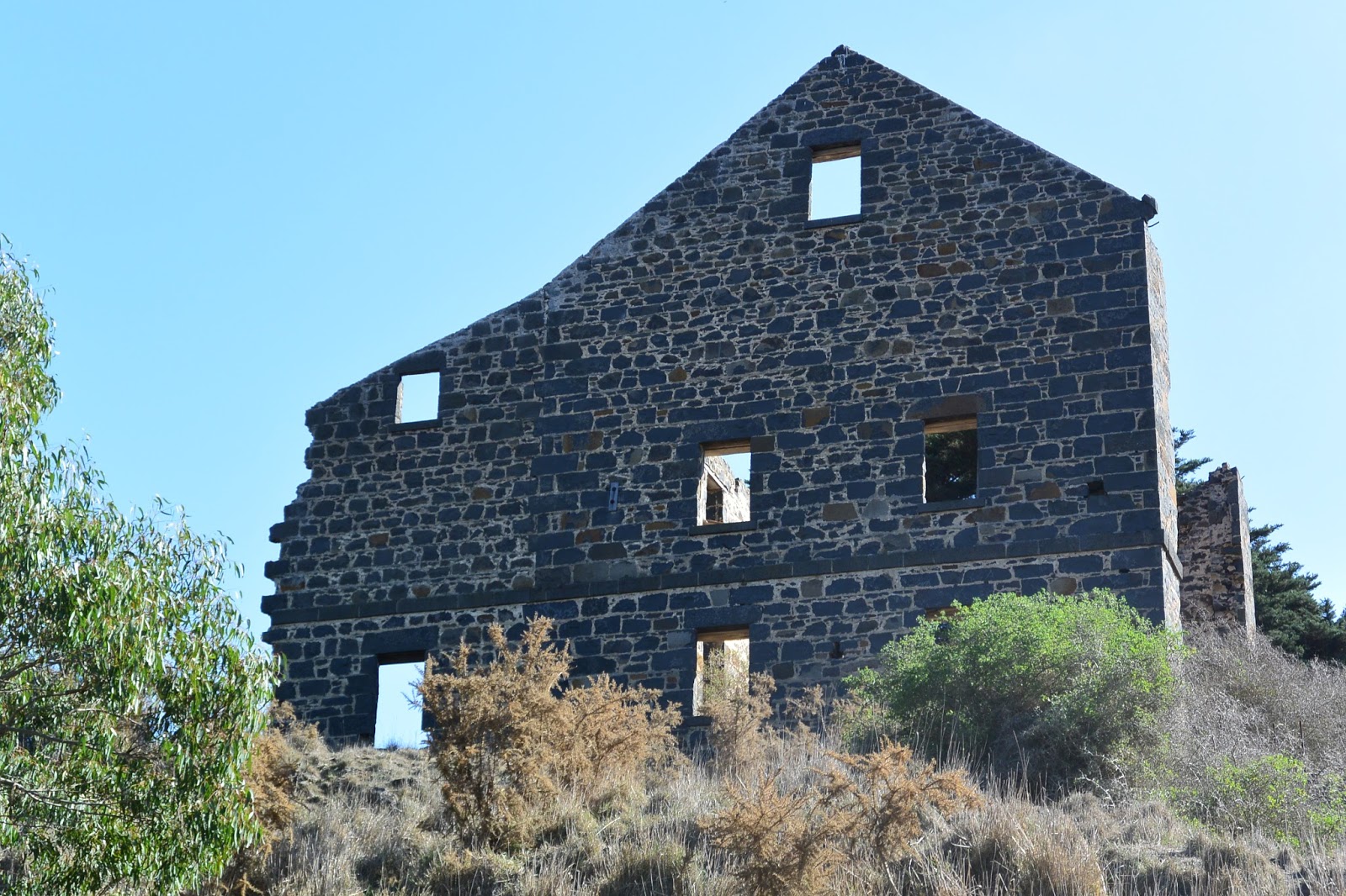
This led us to a relatively impenetrable section where we were required to drag up the bank and re-enter below down a steep-ish embankment through scrub. By that point however, we were in a wide pool situated immediately below the large building I'd remembered from my previous paddle. The building was of course - as discussed in my previous post - the old
Carrah Flour Mill, built in the 1850s by Dr Robert Hope.
 |
| Looking across the river to the ruins of the Carrah Flour Mill |
 |
| Carrah Mill from water level |
From here, the river opened out into a wide, deep and easily paddled section for about 3.5km during which time it flowed north easterly down a long loop. There was little in the way of obstructions which made paddling simple.
 |
| Looking downstream below the mill |
 |
| Looking downstream below the mill |
At one extreme of the long loop was the confluence of the Barwon with Native Hut Creek, after which the river flowed around a sharp bend and back again to the south west.
 |
| The confluence of Native Hut Creek and the Barwon River, looking north |
 |
| Below Native Hut Creek |
Next it was back to another extended section of portage and rock-hopping between pools for around 1.5km before another navigable section of several hundred metres, then more portage, more paddling and so on for around 7.5km.
 |
| Some sections were easy |
Today, the land to either side is open grazing country, although current weather conditions and lack of rain means that the surrounding countryside is also very dry.
 |
| Grazing land, but not much feed to be found |
 |
| More rocks... |
 |
| ...and more reeds... |
Eventually, after around 16km of paddling and hundreds of metres of dragging over and around rocks, reeds and other obstructions and with the sun getting a little low for photography, we decided to call it quits at Murgheboluc and summon reinforcements to collect us. This was definitely a one way paddle!
 |
| Hubby taking his 'yak for a drag |
It was also plan B. Our initial aim (which we knew was probably ambitious given the low water levels), was to push on all the way to the Pollocksford Bridge, however after six hours and what looked to be a significant amount of portage still ahead, we opted to stop at the access road which runs down to the river opposite the Murgheboluc recreation reserve.
 |
| A pretty pool before a large obstruction |
By this stage, the river was quite overgrown and fortunately I'd thought to take a waypoint (GPS position) marking the location of the exit we needed. This was definitely a good idea as the bank at this point was relatively high meaning that the track was not visible from the riverbed.
 |
| Murgheboluc access track - like the sign at the road says "Please shut the gate"! |
So all that remains now is to "paddle" a further 8km section of river from Murgheboluc to Pollocksford which promises to be similar to that immediately upriver. Hopefully this will happen sooner rather than later and more photos will be forthcoming in the near future. Whilst low water levels made hard work of this stretch of the river, it was still possible to get from start to finish, however it would certainly be quicker with higher river levels.


Loved reading this. Don't suppose there were any pics taken of the actual weir near the flour mill?
ReplyDeleteThanks! Do you have a specific interest in the mill? I'm away from home with limited Internet at the moment but do have other photos. The nearest weir would have been about a mile upstream at the top of the weir race and yes, I believe I have some photos. There is also a natural (I think) rock barrier right near the mill. I have photos of that from water level too. I can email some if I have an address.
Deletejeepmate@outlook.com
DeleteMore interested in the Barwon River has a whole more than the mill. Did not know this weir existed. Will probably do a canoe trip myself at some stage. I have done from Pollocksford weir to Baum's weir.
thanks.
Hi Jo
ReplyDeletethere's been plenty of rain this july. I'm thinking of trying this paddle also.
would you recommend inflatable (for rapids and portage) or hard shell recreational yak for ease of paddling? Or unsure (is ok)
cheers
Murray
Hi Murray,
DeleteWhen we paddled it, the water level was very low, so rapids were non-existant, but it would certainly have been handy for portage, because there was lots of that. Having said that, I have no experience with using inflatables. Our 'yaks are plastic sit-on jobs from Anaconda which did the job fine but there was quite a bit of lugging involved. A friend has done the paddle more recently and with higher water levels. He has a similar 'yak to mine from memory but I haven't heard how he went.
So, on balance, I'd probably have to say unsure, but good luck and let me know how you get on.
Cheers,
Jo