A few weeks back, I ventured on to a part of Red Gum Island which I hadn't been to before.
This island is of course, the small, roughly crescent-shaped section of land which lies between the Moorabool and Barwon Rivers at their confluence near Fyansford. The island is separated from the rest of the the land between the two rivers by a short anabranch which breaks away from the Barwon a couple of hundred metres below the paper mill.
Unlike most anabranches (defined as a section of the river which diverts away from the main channel and rejoins further downstream), this one is a little different in that it does not rejoin the Barwon but instead, runs into the curve of the Moorabool about 600m above its confluence with the Barwon.
 |
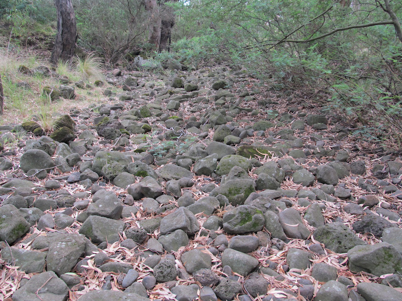
| A river of rocks |
On this occasion, the anabranch was not so much flowing with water as running with rocks. Unless the Barwon is running at least a little high, then the anabranch is dry. This reveals a stream of basalt rocks which look to have flowed down the watercourse over the centuries since those volcanic erruptions of the later Pliocene era (approximately 2 million years ago).
 |
| The anabranch at Fyansford April, 2012 |
Having seen some of the more recent flood events, it is not hard to imagine how these relatively small rocks would be tumbled down with all that rushing water until they came to rest in the anabranch. It also makes me wonder - could we see beneath the waters of the main waterway - what the riverbed would look like along its length. With any luck, we will never see the river run dry enough to find out.
This week, I returned to have another look. This time things were somewhat different:
 |
| The same part of the anabranch at Fyansford June, 2012 |
Recent rain over the past few weeks, including the "almost flood" of earlier this month, meant that the anabranch was well and truly flowing. Instead of a river of rocks, there was now a bubbling stream of water punctuated by several mini-waterfalls.
 |
| The anabranch flowing, June, 2012 |
 |
| The anabranch flowing, June, 2012 |


Hi Jo, found your blog whilst researching Lal Lal, Moorabool and Granite Falls. I'm a landscape photographer from Ballarat, thought you may like to see my adventure last week getting down to Granite Falls.....
ReplyDeletehttp://andrewthomasphotographer.blogspot.com.au
cheers Andrew
PS in a previous life I also used to run marathons...now its photography!
Hi Andrew, love the shots of the falls! Loved the pumping station too. Old architecture is often a favourite. Think I'll have to work on improving my happy snaps. I'm definitely an ammateur!
ReplyDeleteWhich goes for the running too. Haven't made it much over half distance and can only run at the moment (normally I play netball, the running is just for some endurance), but have once again broken my hand, so running it is :(
We have just now returned from Ballarat. I had a bit of a look at the Yarrowee through town, but the weather was too dreadful to seriously investigate. Will have to go back when the weather clears and should probably have a look at Gong Gong too.
The rocky anabranch stream bed was used by local aboriginals as "eel traps" some time in the past. There are middens and scar trees to be found in the vicinity, say within 1km of Red Gum Island.
ReplyDeleteThe summer before the drought broke, the Barwon R was so shallow you could walk across in many places where the river bed is rocky. The river seemed to stop flowing for about 6 weeks (as seen at Buckley Falls weir) and eels in the cm deep pools were coming out of the water to navigate the shallow channels on their way to deeper pools.
Hi Helen. Thanks for your post. That is great to know. I have seen information on eel traps in other rivers and know that the Wathaurong caught eels at the Bunyip Pool, but haven't seen the anabranch mentioned.
ReplyDeleteThe scar trees are interesting too. I often wonder about some of the trees I see. I have looked at the "canoe tree" at Queen's Park and seen two others - one on Waurn Ponds Creek and another on the Moorabool - which look very similar and which I suspect may also have been canoe trees.