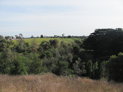
As a reminder, the area in question is a significant strip of land extending from the current Buckley Falls Park, along the south bank of the Barwon as far as the Geelong Ring Road. At the present time it looks something like this...
 |
| ...although perhaps with slightly less water. Looking south across the base of Mt Brandon Peninsula towards Rivergum Dve, during flooding on 16th January, 2011 |
 |
| From the top of Mt Brandon Peninsula looking towards the Ring Road in the distance. The land to the left will include part of the new parkland development |
 |
| Looking at Mt Brandon Peninsula across "gully 1" (see council plans). Development on Rivergum Dve can be seen to the left |
 |
| And the view south from the base of Mt Brandon Peninsula |
 |
| The Ring Road (Geoff Thom) Bridge from the north bank and the site of a future path and pedestrian bridge |
In the short term and assuming the plan is implemented, the initial stages appear to involve revegetation in addition to that which is already being undertaken by the Friends of Buckley Falls group, ongoing weed control and the construction of some walking tracks at the Bunyip Pool end of the precinct.
As for the rest, I guess we'll just have to wait and see, but the prospect of this extension to the river trail, combined with the plans for nearby Batesford South and the Moorabool are an exciting prospect for the future of the Barwon River Parklands project, especially when combined with the prospect of trail extensions beyond Breakwater and the upgrade of park facilities further downriver at sites such as Tait's Point, Ash Road in Leopold and other works in Barwon Heads. More details on the Barwon River Parklands project is available on the Parks Victoria website.
No comments:
Post a Comment