Showing posts with label Bannockburn Shire. Show all posts

17 June, 2016

Four bridges and a ford: Monier mischief

The best-known bridge at Fyansford is without doubt, the Monier bridge. Built in 1899 and opened to traffic on 16th February the following year, the saga of the bridge's construction is described in detail in many places including this webpage so I will settle for a general description here.
The story of the bridge began in 1897 when it was finally decided to replace the original timber bridge built at Fyansford in 1854. The old structure was rotten and in imminent danger of collapse. The first problem was funding. Who would pay for the new bridge? A meeting in September, 1897 discussed the topic and it was pointed out that the bridge at Fyansford not only crossed the Moorabool River, but also crossed the shire boundary between Bannockburn and Corio Shires. Should the shires pay for the new bridge?
Corio Shire were quick to point out that Bannockburn Shire residents derived significantly more benefit from the bridge than its own constituents did as the former often travelled to Geelong. Both shires however were of the same opinion that in fact the majority of traffic across the bridge was not from either shire, but rather from shires further afield who brought produce to Geelong or travelled there to do business. On the that basis, they felt Geelong also derived a significant benefit from the bridge. This was a national road which should receive government funding - oh, and while they were pressing for national road status, they should also request that the steep road out of the valley be cut down too.
Having considered these issues the shires estimated that it would cost around £5,000 to replace the existing bridge and approached the government to contribute half this sum. The government made £1,500 available.
And so a committee composed of councillors and the engineers from both shires was assembled to look into the issue. In March, 1898, Councilor Stewart of the Bannockburn Shire tabled the idea that a revolutionary new system of bridge-making patented by the Engineering company of Monash and Anderson could be employed to replace the Fyansford Bridge. It would be cheaper than a standard stone and iron bridge and once completed, the bridge would require virtually no maintenance and, being new technology, the committee felt the government may be more inclined to increase its financial contribution.
Eventually, by November, 1898 tenders were called for either a steel bridge or a concrete bridge and it was voted that the committee should approach the government to rethink its decision on funding the project. If this was unsuccessful, Corio Shire felt they should instead opt for building a cheap timber bridge or revert to using the ford. The rate payers of that shire after all, would not be significantly inconvenienced by such an arrangement.
It was estimated by the shire engineers prior to tender, that a steel bridge would cost £6,430, however, the quotes received ranged from around £8,500 to almost £11,000. By contrast they estimated that a concrete bridge built using the Monier system would cost in the order of £4,500. The engineering firm of Monash and Anderson who held the patent for this technology in Victoria submitted a tender of just over £5,000 or, including a temporary bridge to be used for the duration of the works, just over £5,300.
In the meantime, the government didn't budge on the issue of funding and instead, recommended that they take their request to the Geelong Town Council. And so discussions continued. In January, 1899 it became clear that the majority of Bannockburn councillors favoured the Monier bridge, however many of the councillors from Corio Shire unsurprisingly, supported the construction of a cheap timber bridge. Whilst various shires and the Geelong Town Council may have been prepared to provide monetary support for the bridge, it soon became clear that it was beyond their legal capacity to contribute financially to projects beyond the borders of their own municipalities. Bannockburn and Corio would have to bear the cost alone.
Finally, after months of wrangling, several changes to the bridge specifications and a number of different proposals - even including a composite steel, timber and concrete bridge - put forward by Monash and Anderson, it was agreed by both councils to accept the original concrete design and at the end of March, 1899 a contract  for £4,506 was agreed upon.
A young John Monash in 1896, not long prior to building
the Fyansford Monier bridge. Image held by Monash
University

In order for construction of the Monier bridge to be completed however, it was necessary to demolish the old timber bridge, so in preparation for this, tenders were called in December, 1898 for the construction of a temporary bridge for around £200.
By early May, 1899 work on the temporary structure was complete and the bridge - located downstream of the site on which the Monier bridge was being built - was ready for public use. Despite its rather flimsy appearance, it was claimed to be of a more sturdy construction than the old bridge which in any case, had been demolished by the end of that month. Despite this, a notice posted by the Corio Shire engineer AL Campbell in the Geelong Advertiser warned that those crossing the bridge with loads greater than two tons did so at their own risk.
Looking north towards the nearly complete Monier bridge with the smaller
temporary bridge in the foreground. Image held by the University of Melbourne

By early May, with the temporary bridge open to traffic and the piers for the new bridge already completed, difficulties between the shires and Monash and Anderson began to arise as payments were delayed or smaller than expected. Supervising engineer Campbell was also deemed slow to approve the ongoing construction. Work did however continue, with the abutments almost complete by the end of June, this despite flooding on the Leigh and Upper Barwon which it was feared would damage both the temporary bridge and the partially-constructed Monier bridge. Only a couple of weeks later, on  August the temporary bridge was out of order when flood waters over topped it.
The Monier bridge under construction. Image held by the University of Melbourne

During the middle of August, the southern side of the bridge was cast with the northern side complete by October at which point shire engineer Campbell took over responsibility for the works. By December, the bridge was essentially complete, with only finishing touches remaining to be completed along with the testing required before payment to Monash and Anderson could be finalised.
Testing was conducted on 16th February, 1900. The completed, three-span bridge was 260 ft in length with the central span measuring 107 ft 6 in, standing 35 ft above water level. The east and west spans measured 67 ft 6 in each. At that time, the central span was the longest Monier span in the country. The bridge was first tested with 14 laden drays - the equivalent of 44 tons. No deflection was detected in the central arch. Next, a 16 ton steamroller was driven across the bridge with a deflection of one tenth of an inch recorded.
The Monier bridge soon after completion. Image held by the State Library of Victoria
The following day, the bridge was officially opened to traffic. There does not seem to have been a formal opening ceremony - as there was for the first bridge - a circumstance which may have arisen due to what became a protracted legal battle over costs for the bridge. The whole affair, which dragged out over many months, began with Monash and Anderson - after consultation with engineer Campbell - claiming a cost for the bridge of £6,142 and expressed a willingness to waive a claim for extra costs. The shires ordered Campbell to reassess the expenditure and then offered £4,500 plus an additional  £750 to cover extras. Monash and Anderson replied by taking the shires to court.
When the case opened in June, the shires through their lawyers disputed the terms of the original contract, claiming a "bulk sum" contract rather than one based on a "schedule of rates". If correct, then the amount of the contract was a fixed sum (in contrast to a schedule of rates), with any extra expense to be borne by the contractors. Extra costs could only be claimed if approved in writing by the shire president. Throughout the course of construction, verbal agreements for extra expenses had been made by Campbell with the assumed knowledge of the committee, however there was no written authorisation from the either shire president. The shires also made a raft of claims denying any wrong-doing on their own part and claiming Campbell's measurements were wrong and that Monash and Anderson had not made any of the additions claimed.
Looking east across the Fyansford Monier bridge, June, 2016

Eventually, the judge decided in favour of the contractors to the tune of £1902,10,0 plus costs, claiming they had acted in good faith and that the shire's actions throughout the course of construction constituted an implicit acceptance of the expenses accruing. Justice Williams also noted that the shires had probably not considered avoiding payment of the extra money until it was suggested by their legal representatives. He also reluctantly indicated that the shires would have grounds for appeal.
Stuck between a rock and a hard place. Corio Shire
Engineer AL Campbell oversaw the work of Monash
and Anderson on behalf of the shires and was required
to give evidence regarding both in court.
Image held by the State Library of Victoria

This of course was precisely what they did. Before the High Court, presided over by Justices Holroyd, a'Beckett and Hodges, the shires returned to court in February, 1902 with the judgement handed down in September that year. Inevitably perhaps and with reluctance, the judges found in favour of the shires. Justice a'Beckett...
...regretted that he had to concur in a judgement which enabled the defendant shires to escape from payment for work, of which they obtained the benefit, and done with the approval of persons believed by the plaintiffs [Monash and Anderson] to effectually represent them. The unfortunate confusion in the documents by which the rights of the contractors were to be regulated was mainly due to the defendants' [shires'] agents. As the result of the confusion, the plaintiffs had failed to secure themselves against the defence set up by the defendants in refusing to pay for anything to which a claim could not be made out under the documents.
In other words, they had no choice but to abide by the terms of the original contract.
Plaque on the Monier bridge commemorating those involved in its construction

Whilst Monash and Anderson gave serious consideration to an appeal, there was every chance they would lose and if successful, their costs would consume any payment awarded and so eventually, in April, 1903 a settlement was finally reached. Monash and Anderson agreed to accept a sum of £450. Their total losses on the bridge at Fyansford totalled more than £3,000.
Next, in April, 1906 - perhaps to the consternation of the shires who had opted for technology largely untried in Australia - it was found that the new bridge was in need of repair at an estimated cost of £200. Routine checks had discovered that the spandrel walls were bulging and that horizontal cracks had appeared at the crown of the western arch on the south side of the bridge whilst there was also a crack in the central span on the north side. The problem was rectified by the addition of steel tie rods inserted in mortar to hold outer spans. It was also recommended that the parapet be removed and replaced with iron fencing. This clearly was not done.
The Monier bridge in 1906 with the Balmoral and Fyansford Hotels to either
side and the Fyansford Cement Works at the rear. Image held by the State
Library of Victoria
It was estimated that the shires would recoup the outlay required to build the bridge after 40 years. In the end, despite its difficult beginnings, the Monier bridge at Fyansford served the people of Geelong, Fyansford and the Western District for 70 years, before it was finally replaced. Those councillors of the Bannockburn and Corio Shires who supported what at the time was a revolutionary project, ensured that the shires more than got their money's worth. Today, the bridge is open for pedestrian access, beside the modern bridge which replaced it.
The Monier bridge, 2015 viewed from upriver

22 May, 2016

Mapping the Barwon Catchment

Before the arrival of John Batman and his party on the shores of Port Phillip Bay in 1835, the indigenous tribes of the Barwon catchment walked the land, following traditional "songlines" which had evolved over thousands of years. The songs and stories of the many tribes, described the land and the physical pathways they used to cross the countryside, enabling them to navigate long distances, passing safely through unfamiliar territory. I discussed songlines in my previous post.
Europeans on the other hand, saw the land very differently to the indigenous population and used very different navigation techniques. The Europeans too used maps, however they drew their maps on paper, measured distance, calculated elevations and aligned everything according to compass bearings. And they way they travelled was vastly different too. Whilst many still walked, others rode horses and drove bullock drays and it wasn't long before the paths of the songlines became the bullock tracks of the squatters. They in turn were followed by the surveyors with their chains and newfangled theodolites who marked out the roads of the selectors and villagers.
The settlers were also quick to start applying their own mapping techniques to their new surroundings. The squatter's runs were plotted out and the bullock tracks which linked them with the towns which began to pop up, were marked as vague wavy lines.
Section of Surveyor Alexander Skene's 1845 map of the Geelong District
showing early tracks and the names of squatters and early landholders
across the catchment. Original image held by the State Library of Victoria
The more the number of settlers increased however, and the more they extended the boundaries of their settled districts, the more maps were created. Not only did these maps indicate direction and location, but there were also administrative maps, electoral maps, geological maps, maps which indicated individual land ownership (an unfamiliar concept to the indigenous peoples), weather maps and many other types of maps besides. Soon the entire colony had been layered with maps and amongst the earliest of these maps were survey maps.
In order to better administer the vast areas of the new colony, the land was formally divided for the purpose of administering the sale and distribution of land. From the late 1840s until the 1890s, the government progressively undertook a comprehensive survey of the  Colony of Victoria, reclaiming the squatters' leaseholds and breaking up the thousands of acres into village allotments and farm-sized blocks. To aid administration, county boundaries were established and within each county the land was subdivided into civil parishes.
Portion of the Victorian Counties Atlas, 1874, showing those counties which fall
within the Barwon Catchment. Image taken from the State Library of Victoria
Initially, the county boundaries were by necessity ill-defined and changed according to need. The following description from the Geelong Advertiser 17th July, 1841, claiming to give the first official description of Grant County's limits, shows both how they changed over time and - like the Wathaurong whose lands it covered - how the new settlers also used the natural landscape to define boundaries.
The Coast Line from the mouth of the Werriby(sic), Port Phillip, round to a point bearing south of the sources of the Barwon [Barwon Heads]. An imaginary line from that point to the sources of the Barwon [the Otways]. the Barwon from its sources to its junction with the Native Hut Creek. The Native Hut Creek from that junction to the Buninyong and Melbourne road(sic). The line of that road to the Werriby, and The Werriby River to its mouth.
By 1871, the 37 Victorian counties as we know them today were in place. Counties and their accompanying civil parishes were - and still are - used entirely for real estate purposes, enabling the physical description of a piece of land.
Section of 1881 Victorian civil parishes map. Original image held by the
State Library of Victoria
With European settlement came the English system of government. Having been declared a separate colony from New South Wales on 1st July, 1851, Victoria needed to put a government in place, however it was not quite the system we have today. The original Victorian parliament was unicameral - having only one house. Called the Legislative Council, it was composed of 16 electoral districts from which 30 members were chosen. Ten were nominated by the Lieutenant-Governor and 20 were elected from the eligible voting population. To be eligible to vote a person had to be a male British citizen over the age of 21 who paid more than £10 per annum in rent or held the freehold for property valued at more than £100. Once again the colony was mapped and divided. This time for electoral purposes. The Wikipedia map below shows the original electoral districts and I have indicated the general area of the Barwon catchment within the black box.
Electoral districts of the original Victorian Legislative Council, 1851.
Original image from Wikipedia
Within a handful of years however, electoral boundaries were being shuffled and in 1856 a second or lower house - the Legislative Assembly - was introduced, resulting in the system we have today.
State electoral districts for both the upper and lower houses of the Victorian parliament have continued to change in response to the growing population. Today there are 88 electoral districts, each corresponding to a seat in the Legislative Assembly. These are combined into eight districts from which five Legislative Council members are elected, giving a total of 40 members in the upper house.
Current boundaries of the state electoral districts (lower house) which
cover the Barwon catchment. Original image from Wikipedia
In 1901, the cartographic landscape of the Barwon catchment changed once again with the advent of Federation. The Colony of Victoria became the State of Victoria and was divided for the purpose of voting into federal electoral divisions. These were (and still are) different to the electoral districts of the state government. The electorates of Corangamite, Ballarat and Corio are all, at least in part, within the catchment.
Federal seats within the Barwon catchment. Original image from Wikipedia
Of course, beneath the federal and state levels of government is local government. In the 19th century, local government stemmed from the need to raise funds for roads and infrastructure, consequently a series of "road districts" were gazetted across the colony. Within a few years, the road districts were transformed into shires which along with cities and boroughs today make up the various municipal districts of the local government system. Not surprisingly, as with state and federal electorates as well as county and parish boundaries, the banks of the creeks and rivers of the Barwon catchment often formed the boundaries of these early shires too. Also in keeping with other levels of government, the number of municipal districts has changed over the years. For instance, in 1915, the Shire of Meredith was amalgamated with that of Bannockburn.
Country Roads Board map, 1961 showing parish boundaries. Original image held by the
State Library of Victoria
In 1994, sweeping changes saw the amalgamation of many smaller shires and city councils in to a lesser number of much larger shires and cities. Where before the catchment contained perhaps as many as many as 15 shires and cities, after the amalgamations, this number fell to around six.
The outbreak of the Victorian gold rush in August, 1851 also saw a flurry of map making. Every digger wanted to know the best route to get to the diggings. As I have written before, there were claims, counter claims, insults and outright lies hurled back and forth between parties with vested interests in promoting their route to the diggings. Maps could not only be used to inform the general public (as below), but also to deceive as Geelong discovered when interests in Melbourne published a "false map".
The relevant section of a reasonably accurate "Digger's road guide to the gold mines of
Victoria and the country extending 210 miles around Melbourne", 1853. Image taken from
the National Library of Australia
 As well as the topography of the land and the roads and tracks which crossed it, the gold rush led to an intense interest in what lay under the surface of the soil. In 1852 Alfred Selwyn was appointed as Mineral Surveyor for the Geological Survey of Victoria and with one assistant and a tent-keeper, set about completing a comprehensive geological survey of the colony. Soil types were assessed, rock deposits dated and the potential presence of minerals noted. Over the years, the department expanded and exists today under the portfolio of the Department of Energy and Earth Resources in the Department of Economic Development, Jobs, Transport and Resources.
Adaption of the 1909 Geological Survey Map of Victoria. Image held by the
State Library of Victoria
Finally, another topic which has always been of particular interest to those living in the Barwon catchment. Rainfall. How much? How little? When? Where? Once again, the indigenous tribes had intimate knowledge of seasonal changes in climate and climate-dependent resources. The European settlers were equally as interested. They needed to know when to plant their crops and where to find water for their stock in different seasons.
Meteorological recording began in Melbourne as early as 1840 and regular, coordinated data collection began in 1854 with the establishment of the Victorian Meteorological Office. The first official report of rainfall data (I could locate) for Geelong appeared in the Victorian Government Gazette dated 21st August, 1857 for the April-June quarter of that year, although references were made elsewhere to earlier data.
Today, rainfall measurements are taken at various points across the Barwon catchment, including Weeaproinah in the Otways, near the headwaters of the Barwon River which has the highest average rainfall in the state. By contrast, the lowlands along the lower reaches of the Barwon, Leigh and Moorabool Rivers lie in the rain shadow cast by the Otway Ranges and receive a significantly lower annual rainfall.
Overview of long term rainfall averages for the Barwon catchment. Graph taken
from the Australian Bureau of Meteorology
Over the years since European settlement, many maps have been produced for many different reasons, dividing the catchment in a multitude of ways. Maps to direct. Maps to divide. Maps to quantify. Maps to persuade, even maps to deceive...

29 August, 2015

Branching out - the Old Five Mile Bridge

In the earliest days of settlement, establishing reliable river crossings was crucial to the growth and prosperity of the new Colony of Victoria. Initially, fords and breakwaters were established and punts or small boats could be used to ferry passengers across larger rivers. Eventually, bridges were built, however they were expensive to construct and maintain and were always at the mercy of the elements. Economic realities then as now, often meant that the longest-lasting or strongest bridge was not necessarily the one built.
 Wood was cheap and readily available and timber bridges were quick to build. The downside however was that they had an effective lifespan of around ten years before substantial ongoing repair and maintenance was required. Stone was another plentiful building material - especially across the basalt plains through which the rivers of the Barwon catchment run - however it was expensive and time consuming to build in stone. As a result, scores of smaller creek and river crossings made do with fords or timber bridges.
One way to minimise costs was to construct bridges from a combination of building materials. Bluestone abutments were commonly used to support a timber deck - as was the case of the Blue Bridge over the Moorabool River on the Yendon-Egerton Road - or they could be added later to reinforce a crumbling embankment. The latter was the case when repairs to the original timber bridge at the Leigh Grand Junction were required.
There were of course, other factors to consider too. During the summer months, timber bridges were at risk from bushfire and constant exposure to water meant rot was a permanent problem. Stone structures were less likely to be affected by fire and were impervious to water, but all bridges were to a greater or lesser extent susceptible to flood damage. Over the years these factors have resulted in a number of bridges across the Barwon catchment which reflect not only the ravages of age and the environment, but also provide a visual time line of changing construction materials and building techniques as progressive repairs were implemented.
The first example which comes to mind is the Old Five Mile Bridge which crosses Sutherland Creek's west branch on the Steiglitz Road from Geelong. Today, the bridge sits disused and all but unnoticed beside the modern, two-laned Ken Middleton Bridge which now carries all traffic. The old bridge however is a time capsule which represents the evolution of bridge maintenance in the Borough of Steiglitz and the shires of Meredith and Bannockburn.
Sign still in place at the bridge
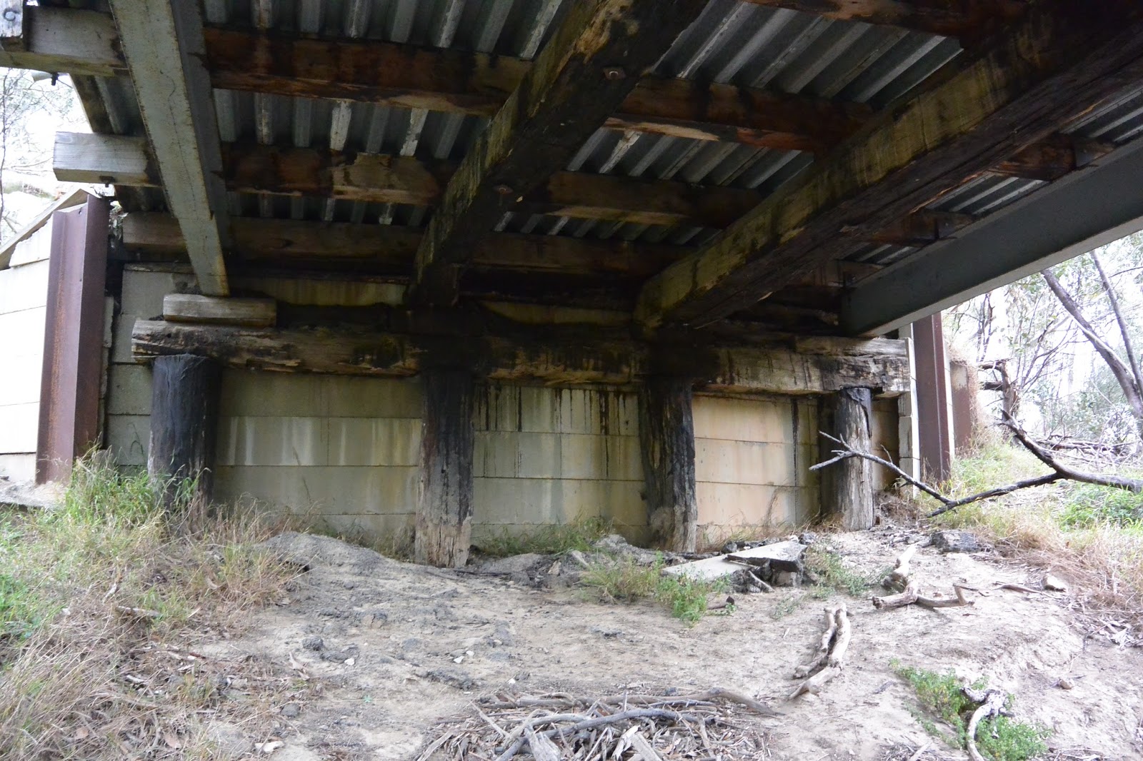
According to the description given by the Victorian Heritage Database, all of the piers, raker piles (angled beams supporting the piers) and some of the timber stringers (beams running the length of the bridge under the deck) are original. The stringers are showing obvious signs of decay. Other beams are newer replacements. To my untrained eye, the crossheads which sit across the top of the piles look newer and clearly the steel girders are also a later addition, as presumably are the crossbeams which they support. Likewise, the deck which is constructed of steel and concrete topped with bitumen would have replaced original timber. The abutments on either bank are reinforced with what appears to be relatively modern concrete slabs, held in place by steel girders driven into the bank and timber posts. Behind the slabs is more timber and concrete.
View underneath the bridge, looking north which shows the timber stringers
showing signs of decay and the original piles along with the newer steel beams
and deck
The problem however, is knowing which repairs occurred when and what is meant by "original". As far as I can tell, there has been a bridge on the site since 1857 when the Victorian Government Gazette gave contract details for a bridge to be built "over Sutherland's Creek on the road to Steiglitz" or 1858 when Roads and Bridges Office in Melbourne called for tenders for "the construction of a bridge over Sutherland's Creek. Approach to Steiglitz gold-field". In view of the latter comment, perhaps the latter date is most likely whilst the earlier date may refer to Hope's Bridge on the same road near Gheringhap.
 It was re-decked in 1871, again required repair in 1873 and then in 1874 was declared unsafe even for ordinary traffic, but little more is mentioned in the newspapers until the spring of 1880 when the Moorabool River and surrounding waterways experienced the largest flood in recorded history to that date.
Several bridges were described as having been washed away, including the Five Mile Bridge. Naturally, it was necessary to rebuild and it was common practice to cut costs by reusing any salvageable material, although whether this occurred here I do not know. With the rebuild underway, it was discovered in March, 1881 that the new structure was being built on soft, loamy, clay soil and in order to secure it, the bridge would have to be partially dismantled and then reconstructed using a significantly greater amount of timber than originally anticipated. The council considered the issue and called for tenders to either repair the existing structure or build a new one. Ultimately it was decided that the better option was to build a new bridge, however rather than replicate the existing 24 ft bridge, it was decided that the new structure would be 12 ft wide. The contract was eventually awarded to E Kennealey whose tender of £114 was accepted. In addition to completing the job, Kennealey also agreed to purchase some of the used timbers from the previous structure, however the following year, with payment still owing, the council abandoned the agreement.
Looking north along the deck of the old bridge. The new Ken Middleton Bridge
can be seen to the left of the picture
It is perhaps also worth noting that the shire engineer in charge of the project would have been Allan Robinson, a gentleman who had held this position since the earliest days of the Meredith Shire in 1864. During the 1880s however he faced allegations of laxity and carelessness in the completion of his duties. Finally at the insistence of the council, he tendered his resignation in September, 1888.
All this reconstruction however was ultimately for naught. In February, 1883 the creek flooded once more and the bridge was destroyed a second time. By September the shire was again calling for tenders for its reconstruction, indicating that a 66 ft wooden bridge over Sutherland's Creek was required. At this time, engineer Robinson had been given a leave of absence pending a council decision on his continued employment and it was left to the acting (and unqualified) engineer Mr J Murphy to deal with the matter. Murphy appealed to the engineer of neighbouring Leigh Shire - none other than CAC Wilson - to draw up plans for the bridge, however Wilson who was on leave at that time, sent one of his sons (possibly Frederick who later served as shire engineer to Meredith) to take the levels. The younger Wilson upon assessing the situation felt that it would be impossible to sink piles deep enough to stabilise the bridge, as the surrounding rock was too hard and too near the surface.
Section of an 1865 geological survey map showing the bridge site. The area is
composed of Post Pliocene clay, gravel and mud (green) and Silurian rock (grey)
with nearby patches of Miocene clay, gravel, shale and sand (brown). Original
image held by the State Library of Victoria
How this issue was resolved, I cannot discover, however it is certain that the bridge was reconstructed. On this occasion, the contract was awarded to F Lee and the works completed presumably without incident. There was a slight mishap however only a few years later in January, 1886 when a carter who was removing a house from Steiglitz township, clipped the handrail of the bridge causing unspecified damage to this and other parts of the bridge.
The bridge was almost destroyed yet again in 1898. This time however, the threat was fire, not flood. Fortunately, the coach service from Geelong to Steiglitz happened to be passing and the driver noticed smoke billowing from under the deck. He quickly raised the alarm at a neighbouring farm and the fire was extinguished before it could take proper hold of the timber decking. It was supposed that a camper had failed to properly put out a campfire underneath the bridge.
The southern end of the bridge showing the concrete abutments and scorched
timbers. The pile on the right has bitumen on its surface which appears to have
melted and dribbled down from above, but when I cannot tell
 There is little further mention of the bridge until 1902 when it was deemed unsafe for loads of over 1 ton. By 1915 things had reached crisis point and in March, it was decided to petition the government for the cost of a new bridge. The engineer at this time was CCP Wilson. I can find no further reference however to any attempt to secure funding for a new structure and in May, 1916 assessment by Bannockburn Shire Engineer ETM Garlick, revealed that four beams on the western (upriver) side of the bridge were completely rotten. Their replacement would provide a patch which would last no more than a year he claimed. Surprisingly then, only a few months later, the bridge was given a reprieve when it was declared that an expenditure of £91 would make it good for a further 12 years.
The bridge as it stands today showing original timbers in along with steel and
concrete additions
At this point, the online trail goes cold. I can find no further mention of what works were carried out on the structure or even whether a new bridge was built as deemed necessary in 1915. It seems likely that however old the original structure (various inquiries have proven fruitless), the steel beams would have been added as part of subsequent repairs as would the steel and concrete in the deck and abutments.
So far, the bridge has defied the odds, surviving fire and flood - most recently being threatened by a grass fire which moved through the area in January, 2014. The bridge continued in service until as recently as 2000/2001 when the Hansard papers for the November, 2000 sitting of the Victorian Legislative Council indicated that funds had been allocated for the construction of a new bridge at the site. An initial payment of $632,000 was estimated with a subsequent payment of $6,000 to follow in the 2000/2001 financial year.
Looking south over the new bridge, named for former Bannockburn Shire
engineer, the late Ken Middleton
Today the Five Mile Bridge stands almost unnoticed along side the newer, two-lane Ken Middleton Bridge which carries all traffic across the creek.


30 October, 2014

Branching out - pushing the boundaries

...and so the Leigh Grand Junction Bridge was built. It was a joint effort - as described in my previous post - by the shires of Leigh, Meredith and Buninyong, however as with all infrastructure, it required maintenance...and that was where things became a little tricky.
As I outlined, after contributing its allocated share to build the bridge, the Shire of Meredith declined to make any further contribution towards its upkeep - a state of affairs which continued until 1911 when the time came to replace the original bridge.
But on what basis did the shire argue that the responsibility was not theirs?
There were two arguments. The first relates to the vexed issue of shire boundaries and will be the primary focus of this post. According to the media of the day, the bridge was built a little north of the point at which the three shires met; Buninyong to the north and Leigh and Meredith Shires to the south, the latter two divided by the Leigh River.
Complications arose however, as the boundaries between the three shires moved over time. This was not an uncommon occurrence and the Victorian Government Gazette records regular boundary changes over the years - including some changes to the area in question.


The site of all the debate
But to go right back, it is perhaps most useful to establish some original boundaries, beginning with the Buninyong Road District (predecessor of Buninyong Shire) which was proclaimed in 1858. At that time it was noted in describing the extent of the new District that part of its southern boundary (which extended either side of the Leigh River for over 18 miles) included the northern boundary of the Mount Mercer Pre-emptive Right.
Later survey maps indicate that this part of the line became the eastern end of the Dereel-Mt Mercer Road. Further entries in the Victorian Government Gazette indicate that this remained the southern boundary of the Buninyong Shire until at least 1869. The line crosses the Leigh River about 700m south of the eventual site of the Grand Junction Bridge.
Next, the Meredith Road District was proclaimed in 1863. The description of its northern most extent on the Leigh River is somewhat unhelpfully indicated as the southern boundary of the Buninyong Road District. So far so good, however in November 1870, things got a little more complicated when it was recommended by the government that a part of Buninyong Shire be detached and instead added to the Meredith Road District.
Why? Well, one possible reason arises from confusion over rates. Land owners within a given shire or road district paid rates to that entity, however land allotments were originally surveyed and titles issued within civil parishes grouped into counties. Since shire boundaries did not necessarily follow parish borders, this meant that in some cases the property of a given land owner, whilst inside a single parish, could fall under the jurisdiction of two shires.
According to the Geelong Advertiser of 10th December, 1869 this was exactly the case for one particular landowner who had received rates notices for the full extent of his land holdings from both the Buninyong Shire and the Meredith Road District - and he wasn't happy! So the suggested boundary change may have been an attempt to resolve such issues.


Small weir below the Leigh Grand Junction Bridge
The section of land (relevant to this post) which was to be ceded to the Meredith Road District was described as extending from Williamson's Creek down to the "current boundary" which presumably was the southern border of Buninyong Shire as described above. This course of action was recommended by the government. I did not find official evidence of its having been enacted, however anecdotal evidence suggests it was.
For the purposes of the Grand Junction Bridge however, it meant that rather than lying entirely within the Shire of Buninyong, by the time the bridge was built, it was now partly within the Meredith Road District. Simple!
Well, no, not really because (as Meredith Shire would later claim), at the time of construction, some or all of the land gained in 1870 was returned to the Shire of Buninyong with the opening of the bridge in 1873. The reason for this was not mentioned as far as I can see and there seemed to be some doubt as to how much land it was. Regardless, by 1881 when the bridge was in need of repair, Meredith Shire claimed it was not liable for the cost as the bridge did not fall within its boundaries (and indeed claimed it never had). Notably at this time, Leigh Shire whose land never extended as far as the bridge at any stage, agreed to pay one quarter of the cost and felt that Meredith Shire should do likewise.
A vain hope. Meredith did not contribute. The wrangling may however have drawn the attention of the state government for in 1882 the two shires (Buninyong and Meredith) were told to sort out their boundaries. They were asked to come to an agreement on a common boundary which followed a survey line, thereby avoiding the original issue of allotments divided between shires. The problem by this time however, was that Buninyong were now opposed to "any severance of their shire" and would only agree to return the territory up to the original boundary. Forgive me if I'm wrong, but didn't that involve shire boundaries dividing allotments?

Survey map showing a section of Cargerie Parish and the most southerly
portion of the Buninyong Shire boundary as established in 1882.
Click to enlarge
Well, it would seem that in the end, Buninyong more than got their way. The new boundary heading east from the river was clearly defined as following the southern border of those allotments which had originally been divided between the two shires. So, from having had a foot in each camp, to belonging to the Meredith Road District these once divided allotments (and a number of properties to the north) now found themselves officially confirmed as part of Buninyong Shire.
Not surprisingly, when the bridge once again required repairs in 1890, Meredith Shire continued to maintain that it was not their responsibility, as the bridge was not within the shire. Likewise, Leigh Shire again argued that Meredith should bear part of the financial responsibility and were quick to express their disappointment at the minister's failure to arbitrate in the matter. None-the-less, Meredith made no contribution to the bridge's maintenance on this occasion or in 1902 when further works were carried out.
Finally, by 1908 the situation had reached crisis point. A new bridge was needed; the old one could no longer be repaired. Buninyong approached Leigh Shire citing a replacement cost of £800 for the new bridge.
Almost two years later by October, 1910 that estimate had risen to £1,000 and Buninyong was requesting that the Meredith Shire contribute one quarter of that cost. As usual, Meredith claimed that they were not responsible and added the rider that due to a fire in the shire hall in 1895 in which all their records were lost, they were unable to prove any liability in the matter.
This time however, representatives of the other shires were not so easily deterred and a "conference" - attended by representatives of all three shires - was held in order to settle the matter once and for all. As expected, the Meredith councillors cited the land handed back to Buninyong at the time the bridge was built and claimed that this exonerated them from any ongoing obligation regarding maintenance. They also pointed out the absence of records due to the fire, but insisted that "all they wanted was to see documentary evidence that Meredith Shire was a party to the agreement [to continue to maintain the bridge] before they took any steps in the matter".
Probably expecting this response, the councillors from the other two shires had turned to their own records from 1869 when plans for the bridge were originally outlined. The minutes from these proceedings some 40 years earlier clearly showed that the then Meredith Road District had undertaken to contribute to the ongoing maintenance of the bridge. Perhaps a little confusingly, they also indicated that the bridge had been built on the common boundary of the three shires (when in fact it would seem that it was built entirely on Buninyong land). Various councillors also claimed that the route of the road had been altered (perhaps to reflect some of the boundary changes), although no documentary evidence of the latter could be found.
Undaunted, the Meredith councillors argued that they had received no correspondence over the duration and that no approach had been made to them for maintenance costs.
On the contrary, claimed Councillor Eason for Buninyong, Meredith had been asked to contribute, but had declined to pay as they did not accept any liability in the matter. Eventually however, after all the arguments had been put forward, including the input of Councillor Vernon, the Leigh Shire President, who had been present forty years earlier at the initial negotiations,  the Meredith Shire representatives accepted their shire's responsibility and agreed to put the matter to council at their next meeting. 
Then (perhaps as a sweetener to ensure the deal to pay the £237/10/- was approved by council), councillor Eason for Buninyong made the following offer:
"owing to the friendly spirit which the Meredith Shire council had received the various delegates [at the conference], it would give him great pleasure to bring before his council the question of giving back to Meredith the land which was conceded to Buninyong 40 years ago".
And that finally, was almost that. After much discussion and despite dire warnings from some Meredith councillors that the east riding of the shire would secede to Corio Shire if forced to pay its portion of the £237/10/-, the council agreed at its meeting on 12th April, 1911 to pay up.
Mark up showing my interpretation of each boundary change. Click to Enlarge

All that remained was to build the bridge and once again establish shire boundaries. These were formally declared and described in the Victorian Government Gazette of 27th September, 1911. In brief, the southern-most section of Buninyong Shire's boundary approaching the Leigh River from the east would henceforth follow the line of the Elaine-Mt Mercer Road from its intersection with the Meredith-Mt Mercer Road up to the bridge whilst on the Leigh Shire side of the bridge, the boundary would continue to follow the road to the Mount Mercer intersection and beyond.
This latter stipulation as far as I can tell, also moved the boundary of the Leigh Shire to the north, ensuring for the first time that the bridge did indeed lie at the junction of all three shires, presumably scotching any further argument over responsibility. Today, the entire area lies firmly within the Golden Plains Shire, formed in 1994 from the amalgamation of the shires of Bannockburn, Leigh, Grenville and part of Buninyong Shire. The shire of Meredith had amalgamated with that of Bannockburn in 1915, only a few years after the new Leigh Grand Junction Bridge was opened.