Showing posts with label Bellarine Railway. Show all posts

03 March, 2015

Branching out: a Moorabool paddle - changing course

After negotiating the rocks, weed and fallen branches in the section of the Moorabool directly below Batesford during our "paddle" on Saturday, we emerged to find ourselves confronted instead by a manmade obstacle. On the bank above us was a handrail following what looked like a pathway. In the river were large chunks of broken concrete and a little further downstream, the bank was lined with concrete and bluestone.
Apparent pathway with handrail and large chunks of concrete breaking down
What we had arrived at was the beginning of a section of the river which was diverted from its original course.
River bank to the right lined with concrete and bluestone
The reason for the diversion however, dates back millions of years to the Miocene period when much of the surrounding land was covered by seawater. As a result, large deposits of limestone built up, formed from the shells of millions of sea creatures, some of which are still found in fossilised form today. European settlers arriving in the 19th century were quick to realise the potential of these deposits and in 1880, Peter McCann (whose descendants still own much of the surrounding land) registered the Australian Portland Cement Co Ltd and commenced production at nearby Fyansford. Struggling to make a profit in the face of cheap imports and using inefficient production methods, the company went into liquidation in 1895 and again in 1904. Peter died in 1908, leaving the nucleus of a profitable enterprise which, under his youngest son Wesley B McCann who acted as manager, was modernised and overhauled. By 1911 the company came under the control of a group of investors and in July, 1912 as part of the move to modernise the company, a ropeway constructed to carry limestone from the quarry to the cement works (then located at the bottom of the deviation). It was officially opened by the Premier on 12th July, replacing horse-drawn wagons and a section of horse-drawn tramway.
Initially, lime used in the production of cement at the works was quarried from a site just north of the Moorabool River (by my reckoning on a line roughly south of Pennsylvania Ave in Batesford). Lime was crushed on the quarry floor and transported to the works via the ropeway.

Concrete-lined channel above the site of the first quarry
In 1924 the ropeway was replaced by a privately-owned 3'6" gauge railway line which ran from the site of the original quarry, crossing the Moorabool twice on wooden trestle bridges, back to the plant.
Image of the Vulcan Engine #4 crossing the trestle bridge 28th November, 1964.
Image from Weston Langford Railway Photography
In 1931, operations were moved to a second quarry site, which had been developed south of the Moorabool. This is the quarry which is still in use today. To service the new facility, a second section of line was constructed, including a branch which allowed for the dumping of overburden and a 1.3km tunnel - the longest in Victoria until the Melbourne city loop was built - which followed a curving path up from the quarry floor to join the original line west of the second river crossing.
Remains of pylons which supported the trestle bridge
All that can be seen of the second trestle bridge today are some wooden stumps, sticking up above the river's surface. I saw no sign of the more northerly bridge.
Following the closure of the original quarry a section of the river was redirected through the old excavations, away from the face of the new quarry. I don't know for sure, but the concrete lining the river upstream of the present quarry (as shown in the photos above) may date to this period.

Diagram showing the rough layout of railway line running between the quarries and the cement works, taken from Light Railways, vol 120, April 1993 which also contains a more comprehensive history of the quarries.
In 1925 the Australian Portland Cement Company was floated on the stock exchange as Australian Cement Ltd and continued to grow, acquiring a number of other companies over the years, to become Australia's largest cement producer, with production rising to 500,000 tons per annum by 1961 when Wesley McCann retired. The railway operated throughout this time, with one diesel and eleven steam engines either shunting on the quarry floor or hauling trucks up and down the 5.6 km line. At the time of its decommissioning in 1966, the diesel and six of the steam locomotives were still in use. All six of these remaining steam engines were preserved and can now be found at the Bellarine Railway whilst the diesel was also preserved but is housed elsewhere.

The floor of the new quarry, showing the diesel and one of the Vulcan engines
as well as the entrance to the tunnel
With the closure of the line, a new method of carting the limestone was needed. To this end, a limestone crusher was installed on the quarry floor with the crushed rock then transferred to a conveyor belt which carried it to the works above. The remains of the conveyor cross the river about 1km south west of the old train bridge and can be seen in passing from the Ring Road.
Remains of the conveyor belt crossing the Moorabool River with the
cement works in the background
In 1980 a bid to extend both the life of the quarry and the supply of lime for the cement works, a proposal was put forward by the company to divert a 4km section of the Moorabool River which was overlying part of the limestone deposit. Moving the river, would add a further 50 years to the lifespan of the quarry, however report by the Ministry for Conservation stated that the increase in lime production would also increase the salinity of the groundwater (which at that time was being returned to the Moorabool) to unacceptable levels.
In the end, a 2.6km diversion of the Moorabool was created with - the company claimed - due consultation as to the needs of flora, fauna and water quality and included measures such as natural curves, tree plantings and pools which would provide habitat for platypus. With these measures in place, the diversion went ahead and to the present day, the river runs through a concrete-lined channel in varying states of repair, along its new course and it was this section of the river which we now found ourselves paddling through in relative comfort. In some places the river was a shallow trickle over a concrete bed, in others, the concrete had broken and fallen away in chunks and there were occasional patches which seemed to have returned to a more natural state.
A section where the concrete appears to have broken away, with an unlined
pool behind, close to the site of the original quarry.
This persisted until we reached a more formed section of the channel which begins at the outflow point from the Batesford Quarry. As far as I can tell, the chute through which the water is returned to the river was constructed at the same time as the realignment took place. Only water which did not exceed acceptable levels of salinity was returned to the river with the remainder pumped to Corio Bay. Google Earth shows water flowing through the chute in January, 2010, but dry as early as 2004 and as late as 2013, either side of this date.
Outflow chute from the nearby quarry
Now, however, it is flowing and in use as a result of an environmental win for the Moorabool which occurred in 2011 when the then Victorian Coalition Government reached an agreement with various water and environmental authorities and the current quarry owner Adelaide Brighton Cement Ltd (ABCL), to return ground water pumped from the quarry, to the Moorabool instead of the bay. The agreement allowed for a return of about 8 mega litres per day (around 3,000 mega litres per year) to the lower Moorabool River, helping to improve environmental flow levels below that point for both the Moorabool and the Barwon Rivers.
Immediately below the outflow, the channel is much more formed, with high walls rising to at least a couple of metres - giving the impression of paddling through a drain - for several hundred metres before returning to lower, concrete-lined banks.

High-walled channel
Paddling down the channel
Every few hundred metres from the outflow until the end of the realignment are little weirs which presumably regulate the flow of water as it travels down a fall of about 12m to the end of the channel. At this point, the diversion ends and the river returns to its natural state and original course, passing only a few hundred metres below the Ring Road.

A series of five small weirs in the channel below the walled section
Below this point are the remains of both the trestle bridge and the conveyor belt shown above.
I will finish this post at the end of the channel and with the end of an era. In 2001, the owners of the Fyansford Cement Works (by that time, Adelaide Brighton Cement Ltd) decided to close the plant. But what to do with the quarry? Operating for over 100 years and with more than 100 million tonnes of limestone and overburden extracted by 2001, there remained enough limestone to keep the quarry operational for at least another thirty years.
Other markets had to be found, so Adelaide Brighton Ltd in conjunction with the McCann family developed new products and sourced new buyers. Today, according to their website, they supply a range of lime products both for construction and agricultural purposes and have also taken the opportunity to develop a range of crushed rock toppings and several fine sand products, which come from a layer of sand underlying the limestone which was not previously utilised during the cement works era.

30 August, 2014

The line that couldn't

Whilst tromping around in the marshy area opposite the bird hide at Jerringot Wetlands recently, I made an interesting discovery. As I skirted the edge of the swamp near Barwon Heads Road, I stumbled across an elevated causeway which lead me right through the middle of this otherwise very waterlogged area. Naturally, I followed it to see where it went.
The course took a gentle curve from Barwon Heads Road and lead me round towards the car park of the golf course where it disappeared into nothingness in the grass and weeds near the gateway to the car park. The route I took was grassy (albeit overgrown) and relatively firm underfoot, unlike the surrounding land which was all swampy.
The causeway through the wetlands
By the time I had completed my short walk, I knew what I had found and also had a fair idea of what it had once belonged to. I had seen it mentioned whilst researching an earlier blog post. I was walking along what I suspect is the only surviving remnant of the old Belmont Common Railway from the 1970s.

Belmont Common Railway.
Taken from http://www.brownfam.com.au/ROLL110/ROLL110.htm
My first tip off came when I discovered some scattered blue metal such as that used on railway lines, lying on the ground. Then, just to confirm my suspicions, I spotted a couple of old wooden sleepers embedded in the grass, slowly returning to nature. Definitely a train line.
A quick check of Google Earth when I arrived home provided further evidence. A thin, green band can be seen curving through the wetlands from the intersection of Barwon Heads and Settlement Roads towards the road leading to the golf course.
Now it was time for a little more investigation. Where did the line run? What was its history? I knew the basics but not much more. My brother soon revealed that he remembered traveling on the train as a small child and being terrified by the steam whistle. I have no memory of it, however further research revealed quite a few details.
The Belmont Common Railway line. This image compiled for me
by Chris Bridge shows Google Earth overlaid with a 1978 Melways
Map and his rough estimate of the planned line. The red line
shows the section of track which which was built whilst the peach
shows the intended section which was never completed. The latter is
based on details from the following article:
http://www.sydneytramwaymuseum.com.au/members/Trolley_Wire/152%20-%20Trolley%20Wire%20-%20Jun%201974.pdf
The Belmont Common Railway as it was known was established in 1970 and later that decade would evolve into the Bellarine Peninsula Railway. However, it all began in 1966 when the Fyansford Cement Works shut their private railway line (1926-1966). Fortunately, the six remaining steam engines and one diesel loco which the company had used to carry limestone to the works on the hill were all preserved.
As part of this process, in 1968, two of the smaller engines were handed over to the Geelong Division of the Australian Railway Historical Society who opened a museum site on Belmont Common (near KMart) and in 1969 began running services on a short length of track. In its day it was the only operational main line railway museum in the country and soon extended across the common as far as Breakwater Road. By 1974 there were four engines with a variety of rolling stock offering rides for tourists on Sunday afternoons and public holidays.

Belmont Common Railway with KMart in the background.
Taken from https://www.flickr.com/photos/24609616@N05/sets/72157626420795881
One of the engines acquired by the Belmont Common Railway was engine #4 a 0-6-0T built in 1916 in Pennsylvania, USA at the Vulcan Iron Works:

Engine #4 on the Australian Portland Cement Company line at Fyansford.
Taken from: http://www.brownfam.com.au/ROLL50/ROLL50.htm
Engine #4 on the Belmont Common Railway
Engine #4 in 2007, restored and running on the Bellarine Railway (photo
courtesy of Wikipedia)
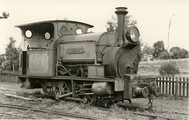
The second was engine #6 - a 0-4-2ST built in 1903 by Hudswell Clarke & Co., Leeds, England. It and three others were originally used in South Australia by the Wallaroo and Moonta Mining and Smelting Co. Ltd in their copper mines but were purchased for use at the cement works when the copper mine closed.
Engine #6 at the Fyansford Cement Works.
Taken from: http://www.brownfam.com.au/ROLL50/ROLL50.htm
Looking at photos of engine #6 during its time on the Belmont Common Railway, it is seen sporting the name "Wesley B McCann" which was the name of the manager of the Fyansford Cement works, however at the works, this was the name used by the diesel engine and not (as far as I can tell) by #6.
Engine #6 at Belmont Common Railway. Taken from the Stephen Haby
Collection, National Library of Australia
Initially it was intended to extend the Belmont Railway in a full loop around the common and back along the river with a further extension planned to take the line towards Queen's Park, but after the track was several times affected by flooding along the river, it became clear that this plan was unfeasible.
Engine #6 pushing a tourist service on Belmont Common.
Taken from http://www.brownfam.com.au/ROLL110/ROLL110.htm

Fortuitously however, in 1976 the decision was taken to close the Geelong-Queenscliff branch line and the Belmont Common Railway took the opportunity to move operations to Queenscliff. Fundraising during 1976 and 1977 along with a government grant enabled the line to be regauged to the narrower 3ft 6in used by the Fyansford engines and in May, 1979 the first services ran, carrying tourists between Queenscliff and Laker's Siding on the reopened line which was soon extended to Drysdale Station.
Today, from its humble beginnings on the Belmont Common, the Bellarine Railway has expanded to include engines and rolling stock from across the country and in recent years, the six surviving steam engines from the Fyansford Cement works have been reunited on the Bellarine Railway.

13 June, 2013

Backing the Black Line

...and so...back to trains...
After the successful construction of both the Melbourne-Geelong and Geelong-Ballarat railway lines, the push was on for a line which would service the south west of the state and it was with this in mind that the line from Geelong to Winchelsea opened in 1876. In following years the line was extended as far as Port Fairy, although the section beyond Dennington is now closed and forms the newly-opened (May, 2012) Port Fairy-Warnambool Rail Trail.
First however, like the Ballarat line, a route had to be chosen. One rejected suggestion was to extend the line via an existing branch to the waterfront on to Limeburners Point, from there heading inland to cross the Barwon River at Breakwater. History shows that this option was not taken up, but in the 1850s, this was by no means certain. Letters to the local media pointed out the benefits of a rail link to Point Henry, enabling the unloading of cargo from vessels unable to cross the sandbar and enter Geelong's inner harbour, prior to the dredging of the Hopetoun Channel which was not completed until 1893.
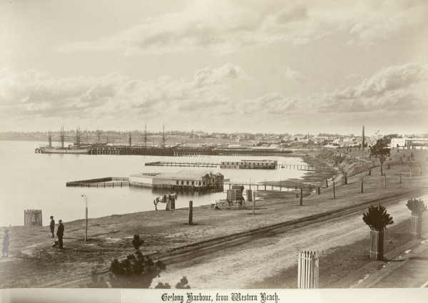
Corio Bay from Western Beach, 1880 showing the Railway Pier (Cunningham
Pier)
This was considered a matter of some importance as both Geelong and Melbourne competed for incoming trade. Routing the line to the south west via Limeburners Point - with a train or tram connection to Point Henry - made economic sense. An extension to Queenscliff where cargo for Geelong could be unloaded directly rather than via Melbourne was also discussed. In 1867 a select committee recommended that a rail line to Colac follow "Corio Terrace" (presumably branching off the existing line to the Railway Pier) as far as "Sydney Place", turn to cross the Barwon at Breakwater and continue on to Germantown (Grovedale), passing 5 miles south of Winchelsea and through Birregurra before terminating on the southern shore of Lake Colac.
By 1873, engineers' reports were being tabled in the Victorian parliament, considering three different options: known as the black line, the red line or the green line. The green line which it seems was favoured by the Commissioner of Railways did not include Geelong at all, but saw a line branch off the existing Geelong-Ballarat line at Leigh Road (now Bannockburn). Requiring only 40 miles of track to be laid but resulting in a total route which was 5 miles longer than the black, it was considered cheaper to construct.
Bannockburn (Leigh Road) Station
From the reports of the day, it seems there was fierce lobbying from all quarters, with allegations of lies, distorted estimates and vested interests claimed all round, however the proponents of the black line won out in the end. This more direct route it was argued, would bring more benefit to more people, opening up vast new landholdings in the process - exactly the claim made by advocates of the green line. The third or red line, deviated somewhat to the north of the black line but does not seem to have been seriously considered by any party.
Having chosen the black line, the major stumbling block was how the new track should leave Geelong. The idea of a rail link to Point Henry seems to have disappeared from the agenda by this stage but a report in The Argus of 9th April, 1873 spells out the various options considered:
With regard to the question of the tunnel for getting out of Geelong the first estimate of its cost was £95,000, but recent surveys showed that a line could be adopted by Fenwick-street, whereby the cost of the tunnel might be reduced to £59,000. Two other lines had also been surveyed - one by the Botanical gardens, in which the tunnel would only cost £64,000, and another by Sydney-place, crossing near the hospital, in which a tunnel would cost £74,000.
Rail tunnel from Geelong Station to McKillop Street
Another point in favour of the black line was that a branch to Queenscliff would be a simple matter if the route through Geelong was chosen. Despite debate over the need for such a line at the time, the coming of the military to Queenscliff, saw the line built only a few years later, opening in 1879
 (see previous post). In addition, a short branch line to the old Geelong racecourse from Marshall opened in 1878 (see this previous post). This would not have been possible had the green line been chosen.
History of course shows which tunnel was eventually built. Then as now, the politicians making the decision were subject to the influence of lobbyists and money but had these forces been otherwise, the landscape of the Barwon  may be very different today.
The decisions made then determined the two points at which rail bridges still cross the Barwon today: Breakwater and Winchelsea, not, as the proponent of the "single great trunk line of railway for Victoria" would have had it (see this post)  at Melville's Quarry near what is today the west end of Noble Street, or at Buckley Falls.
One detail however is not so dissimilar to that suggested in his letter of 1857 where he indicated that the line should run "50 chains" (a little over a kilometre) due south from Geelong Station. The decision to choose the Fenwick Street option saw the line travel due south for exactly that distance, however rather than a sweeping curve to the west "between Newtown Hill and the Barwon" (presumably in the vicinity of West Fyans Street) as proposed, the line as we know headed south east before making a sweeping curve to cross the Barwon at Breakwater.

Vintage Rail steam engine R707 entering the tunnel May, 2013
When all the debate was done and dusted, the first sod on the new Geelong and Colac Railway line was turned by the Mayor of Geelong at a site near Johnstone Park on 24th October, 1874. A holiday was declared, military and civil displays were held for the populace - of whom 5,000-6,000 turned out to witness the event - flags and bunting flew from ships and buildings across town and three cheers were given for the "Black Line".
At a subsequent banquet held for the dignitaries, the expected speeches were made and toasts proposed. It was clearly stated that this was only the beginning and that extension of the line to Queenscliff and Camperdown should be urgently promoted. The mayor it was noted, apologised for the absence of "the members of the ministry and a number of other gentlemen." With the whole event having the distinct air of a victory party for the Black Line, one can't help but wonder whether some of those absent gentlemen were proponents of the green line.
The original timber rail bridge over the Barwon River at Breakwater, 1937,
reproduction rights held by the State Library of Victoria
From this point, building continued apace with the complex and expensive construction of the tunnel and bridge at Breakwater being a priority which took about 12 months to complete, thereby allowing the line itself (thus connected to the existing line) to be used for the transport of materials for further construction.
The original rail bridge over the Barwon at Breakwater was a timber construction some 186m in length and only a short distance further down the line a similar but smaller bridge spanned Waurn Ponds Creek. From this point onwards, the track works were considerably simpler, but no less controversial.
Current Breakwater rail bridge built in the 1960s to replace the original
The second rail bridge across the Barwon was built at Winchelsea, however the original route surveyed for the "Black Line" saw it pass some miles south of Winchelsea, instead favouring selectors on the edge of the Cape Otway forest in the vicinity of Deans Marsh. Once again, the lobbyists were out in force with one scathing critic of the  "Winchelsea Deviation" reported thus in The Argus of 26th January, 1876:
One gentleman wanted to know what Winchelsea had done

"That the claims of the forest should be sacrificed for its aggrandisement. As a township it claimed to be a centre of population, and the father of the shire. He regretted to say it was the centre of a vast area of arid plains, only fit for a few sheep-walks, and scarcely suitable for that; that the few farmers in the neighbourhood had deserted their holdings, and the land for miles around was held in the hands of two or three individuals; and that as a township it had fallen into decay, and only existed in the form of a couple of publichouses(sic), one or two stores, and a few shingle shanties."
In spite of such opinions and perhaps even despite the original route providing a greater boost to the economy, the Winchelsea Deviation was confirmed as the passage of choice. This second section of the track past Freshwater Creek included some 40 bridges and culverts, one being the second crossing of the Barwon at Winchelsea. Like the first at Breakwater, this bridge was a timber construction, but at only 146m in length, shorter than its downstream counterpart.
VLine train from Warnambool crossing the Barwon on the present-day
Winchelsea rail bridge. The first timber bridge was replaced at some point
 by this concrete and steel girder construction
 Finally, after all the debate, significant engineering hurdles and several years of hard work, on 24th November, 1876, the much awaited first stage of the Geelong and Colac Railway was opened to Winchelsea.
A train carrying dignitaries including the Commissioner of Railways who conducted the formalities was dispatched from Melbourne and further notables were collected in Geelong before proceeding to Winchelsea where the residents of the district greeted them with the expected pageantry, speeches and of course, a banquet. The worthies then took a turn around the town before piling back onto the train and heading for home, leaving the good residents of Winchelsea to hold a ball to further mark the occasion.
The following year, the section of track to Colac was completed and - as hoped from its inception - subsequent decades saw the extension of the line to Camperdown (1883), Terang (1887), Warnambool (1890) and Port Fairy (1890). In all, one would have to say, a resounding victory for the supporters of the Black Line.
And now, almost 137 years later as I write this post, I can hear the trains still travelling along the route envisioned by such illustrious names as Levien, Johnstone, Lang, Thomson, Armitage, Sladen, Austin and many more...

08 April, 2011

"Ring! Ring!"

Riders along the Barwon
Ring Road that is! Today's escapade saw us take to the bikes again to investigate the relatively new track which runs alongside stage 1 of Geelong's Ring Road. Rather than take a shorter ride across town and fight with the traffic, we chose to take the scenic route and get our dose of the river along the way. I couldn't resist the urge to grab a "large, weak, skinny cap, please" from Barwon Edge on the way past and we sat at a conveniently located table a little further up the track to have morning tea, watching the usual array of cyclists, joggers, walkers and - a new one on me - a pair riding horses.
And so to Fyansford and the one hitch with this particular route - the cement works hill. Taking it somewhat slower than my last attempt and at a walk after losing my chain, we made it to the top then headed for the Gabrielle Blythe Linear Park for the ride around to Church Street.
This is not the most direct route to the Ring Road track, but it is more scenic than McCurdy Road which has the added disadvantage of no bike lane (although traffic is not heavy).
Lewis Bandt Bridge on the Geelong Ring Road from
the Ted Wilson Trail
As I have mentioned previously, I would also like to see the linear park provide an alternate route to busy Church Street by which to reach the waterfront.
Our detour turned out to be well worthwhile as we came across a group from the Bellarine Railway who were just starting the process of ripping up the rails as I had seen discussed in the papers only a week or so ago. We were informed that these rails would be re-laid in a section of the Bellarine line near Laker's Siding as they were longer than the existing rails and the resulting reduction in joins would mean a smoother ride for the trains.
Leaving the guys to their work, we headed to Church Street and then via the bike lane, the short distance to its western end. Had we chosen to ride in the other direction, we could have connected - as we did on our previous ride - with the trail around the bay, but this time, we were headed north.  
From the end of Church Street, it was a matter of metres to the beginning of the Ted Wilson Trail and a short stop to take in some sweeping views of the Moorabool Valley, the old quarry at Fyansford and the Barrabool Hills. 
Before we continue, it is pertinent to mention that Ted Wilson, after whom the trail is named, is a now-retired police officer from Geelong who was instrumental in establishing the Bikeplan program which was piloted in Geelong in the 1970s and 80s and in developing the Bike Ed program which is still taught in Victorian schools today. Ted was also responsible for the re-introduction of police bike patrols across the state in the 1990s. Now, where was I? 
View towards the Batesford Quarry
The Church Street end of the trail was perhaps the most picturesque section which otherwise spends much of its distance shielded from the traffic of the Ring Road behind the large, steel noise barriers. On the other side, the track opens on to suburban backyards and in some parts, on to neighbouring parkland. From the intersection of the Ring Road with the Midland Highway (aka Ballarat Road), there is a good view of the Batesford Quarry, a little further up the Moorabool River.
Along its length, the track is well made from concrete and makes for good riding with minimal road crossings over fairly even terrain up to Cowie's Creek. From there it heads downhill to - I am informed by the local media - Broderick Road in Corio, a total distance of 11.4km. However, we did not have time to go further on this occasion, so discovering the remainder of the trail will have to wait for another day.From this high point above the creek, the view extends north towards the You Yangs Regional Park and west across the northern suburbs of Geelong to the Shell oil refinery which, whilst rather industrial and mundane during daylight hours, becomes quite spectacular at night when it is ablaze with lights.
Looking south along the Ted Wilson Trail
Further contributing to the somewhat industrial feel is the looming presence of high-voltage power lines running above the track for some of the way. Clearly this is a new pathway which has had little time to develop. A concerted effort at tree-planting could go a long way to breaking up those somewhat bland sections which do not have a substantial view. Tree-cover would also provide a significant boon to the local bird-life and on a warm day such as today, would provide some welcome shade for those using the trail.
Another aspect which was brought to my attention was signage. The comments were made on another website bemoaning the lack thereof and in retrospect, yes, they have a point. By word of mouth I knew the trail started at the bottom of Church Street, but there was no sign at any point to inform me of this, nor, as was also pointed out, is there any sign at the major road-crossings (at least one of which required multiple sets of traffic lights to negotiate) which shows where or if the path continues on the opposite side of the road.
Despite these shortfalls, this is still an interesting and well-constructed trail and I am looking forward to investigating the remaining kilometres to Broderick Road at some point in the near future....

03 April, 2011

Still on the rails...

Perhaps not surprisingly, disused railway lines provide excellent opportunities for councils and local communities to develop nature trails and linear parklands and as I discussed in my last post, this is the case in Geelong. Of course, the old line to the cement works is not the only linear park in the region and not even the first I discovered as a result of my perambulations.
Queenscliff Station
Nor is it alone in linking to the Barwon and the network of trails across Geelong.
A much more extensive and so far, better developed, linear park is the Bellarine Rail Trail which extends essentially from Swanston Street in South Geelong (which in turn links via the bike lane to the Barwon), all the way along the old Queenscliff line, through Drysdale to the little seaside town of Queenscliff.
The trail follows the route of the former South Geelong-Queenscliff railway line which was constructed in 1878/1879 primarily to service Fort Queenscliff. The new line enabled the movement of troops and supplies back and forth from Melbourne. The Fort was a key stronghold in the defence of the capital during times of war, being located at the narrow entry point into Port Phillip Bay.
Steam train at Queenscliff Station
At the same time, Queenscliff was - and from its establishment in 1852 - always has been a tourist destination and the railway line also serviced this industry as well as providing transport for the permanent population. Whilst it was never the busiest of lines, it was none-the-less and important link in Victoria's rail network, serving the Bellarine Peninsula through various changes in fortune until its final closure in 1976.
Almost immediately, the Geelong Steam Preservation Society stepped in and from 1979 ran the line from Queenscliff, initially to Laker's Siding and then to Drysdale as a tourist facility with their base of operations being Queenscliff. The service continues to run to the present day using steam and diesel locomotives to pull the heritage carriages between Queenscliff and Drysdale.
The Bellarine Rail Trail
near Leopold
It has been suggested that it might be possible to extend the rail service as far as Curlewis in the future, however that is a distant goal.
Interestingly, the railway has recently acquired three engines from the Puffing Billy museum. Two of these spent their working lives on the privately-run "Fyansford Cement Line" which carried limestone from the quarry below to the cement works above for storage or transport on the Fyansford branch line. Beside the Queenscliff line some distance outside of Drysdale, is a siding which stores rollingstock, including as it happens, a number of goods wagons also from the cement line.
Further information on the Bellarine Railway can be found at the following address: http://bellarinerailway.com.au/
Engine built by the Vulcan Iron Works
which worked at the Fyansford cement
works, now at the Bellarine Railway
Whilst the train runs only between Drysdale and Queenscliff, for those more interested in riding, running or walking, the good news is that the Bellarine Rail Trail - as mentioned - extends the entire distance from Geelong to Queenscliff through the surrounding countryside and the outskirts of Geelong.
At one time or another I have covered all of the trail either by bike or running. I have run the trail from Queenscliff to Drysdale on three occasions in various weather conditions - including this January through mud, rain and puddles. The terrain is undulating and scenic being both coastal and rural with the usual array of bird and plant life, complemented by sheep, cattle, horses and hay bales. On each occasion I have run to Drysdale then caught the train back to Queenscliff with various family members.
A year or so ago I also ran the remainder of the trail from Drysdale to South Geelong and then home on one occasion (also in the rain as I remember) and in recent weeks have cycled the trail from the Bellarine Highway to Drysdale and back.
The trail along most of its length is a loose gravel path, however there are sections through the outskirts of Geelong, Leopold, Drysdale and the approach to Queenscliff which are surfaced with bitumen. Up to Drysdale, the trail predominantly runs along the original line of the rails, however beyond Drysdale the path runs beside the railway line, crossing back and forth at various points.
Hereford cow outside Drysdale
Whilst as I mentioned, I have covered the entire distance at one time or another, I have yet to do it continuously either riding or - a goal I have long harboured - running. The distance from the Showgrounds in South Geelong to Queenscliff Station is around 34 kilometres, about 11 kilometres further than my longest run to this point, but one of these days...
Along all sections of the trail there are road crossings, however most are small, rural roads posing no real difficulty either riding or running. The two major road crossings I believe now have traffic lights. Despite this, a "training run" which was staged annually in about September running the whole distance of the trail has in recent years been changed to an out-and-back run between Queenscliff and Drysdale; the same distance as
the original run, but without the bragging rights of the former.
Details concerning the Bellarine Rail Trail and the Friends of the Bellarine Rail Trail group can be found at the following site: http://www.fbrt.com.au/fbrt/main/home.asp