Showing posts with label Charles Anthony Corbett Wilson. Show all posts

29 August, 2015

Branching out - the Old Five Mile Bridge

In the earliest days of settlement, establishing reliable river crossings was crucial to the growth and prosperity of the new Colony of Victoria. Initially, fords and breakwaters were established and punts or small boats could be used to ferry passengers across larger rivers. Eventually, bridges were built, however they were expensive to construct and maintain and were always at the mercy of the elements. Economic realities then as now, often meant that the longest-lasting or strongest bridge was not necessarily the one built.
 Wood was cheap and readily available and timber bridges were quick to build. The downside however was that they had an effective lifespan of around ten years before substantial ongoing repair and maintenance was required. Stone was another plentiful building material - especially across the basalt plains through which the rivers of the Barwon catchment run - however it was expensive and time consuming to build in stone. As a result, scores of smaller creek and river crossings made do with fords or timber bridges.
One way to minimise costs was to construct bridges from a combination of building materials. Bluestone abutments were commonly used to support a timber deck - as was the case of the Blue Bridge over the Moorabool River on the Yendon-Egerton Road - or they could be added later to reinforce a crumbling embankment. The latter was the case when repairs to the original timber bridge at the Leigh Grand Junction were required.
There were of course, other factors to consider too. During the summer months, timber bridges were at risk from bushfire and constant exposure to water meant rot was a permanent problem. Stone structures were less likely to be affected by fire and were impervious to water, but all bridges were to a greater or lesser extent susceptible to flood damage. Over the years these factors have resulted in a number of bridges across the Barwon catchment which reflect not only the ravages of age and the environment, but also provide a visual time line of changing construction materials and building techniques as progressive repairs were implemented.
The first example which comes to mind is the Old Five Mile Bridge which crosses Sutherland Creek's west branch on the Steiglitz Road from Geelong. Today, the bridge sits disused and all but unnoticed beside the modern, two-laned Ken Middleton Bridge which now carries all traffic. The old bridge however is a time capsule which represents the evolution of bridge maintenance in the Borough of Steiglitz and the shires of Meredith and Bannockburn.
Sign still in place at the bridge
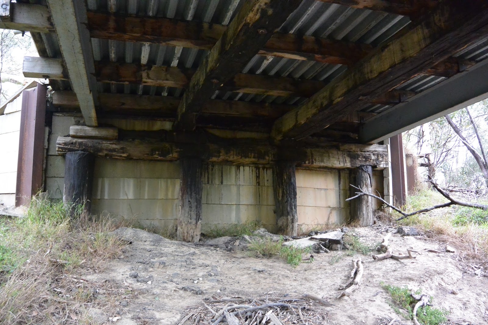
According to the description given by the Victorian Heritage Database, all of the piers, raker piles (angled beams supporting the piers) and some of the timber stringers (beams running the length of the bridge under the deck) are original. The stringers are showing obvious signs of decay. Other beams are newer replacements. To my untrained eye, the crossheads which sit across the top of the piles look newer and clearly the steel girders are also a later addition, as presumably are the crossbeams which they support. Likewise, the deck which is constructed of steel and concrete topped with bitumen would have replaced original timber. The abutments on either bank are reinforced with what appears to be relatively modern concrete slabs, held in place by steel girders driven into the bank and timber posts. Behind the slabs is more timber and concrete.
View underneath the bridge, looking north which shows the timber stringers
showing signs of decay and the original piles along with the newer steel beams
and deck
The problem however, is knowing which repairs occurred when and what is meant by "original". As far as I can tell, there has been a bridge on the site since 1857 when the Victorian Government Gazette gave contract details for a bridge to be built "over Sutherland's Creek on the road to Steiglitz" or 1858 when Roads and Bridges Office in Melbourne called for tenders for "the construction of a bridge over Sutherland's Creek. Approach to Steiglitz gold-field". In view of the latter comment, perhaps the latter date is most likely whilst the earlier date may refer to Hope's Bridge on the same road near Gheringhap.
 It was re-decked in 1871, again required repair in 1873 and then in 1874 was declared unsafe even for ordinary traffic, but little more is mentioned in the newspapers until the spring of 1880 when the Moorabool River and surrounding waterways experienced the largest flood in recorded history to that date.
Several bridges were described as having been washed away, including the Five Mile Bridge. Naturally, it was necessary to rebuild and it was common practice to cut costs by reusing any salvageable material, although whether this occurred here I do not know. With the rebuild underway, it was discovered in March, 1881 that the new structure was being built on soft, loamy, clay soil and in order to secure it, the bridge would have to be partially dismantled and then reconstructed using a significantly greater amount of timber than originally anticipated. The council considered the issue and called for tenders to either repair the existing structure or build a new one. Ultimately it was decided that the better option was to build a new bridge, however rather than replicate the existing 24 ft bridge, it was decided that the new structure would be 12 ft wide. The contract was eventually awarded to E Kennealey whose tender of £114 was accepted. In addition to completing the job, Kennealey also agreed to purchase some of the used timbers from the previous structure, however the following year, with payment still owing, the council abandoned the agreement.
Looking north along the deck of the old bridge. The new Ken Middleton Bridge
can be seen to the left of the picture
It is perhaps also worth noting that the shire engineer in charge of the project would have been Allan Robinson, a gentleman who had held this position since the earliest days of the Meredith Shire in 1864. During the 1880s however he faced allegations of laxity and carelessness in the completion of his duties. Finally at the insistence of the council, he tendered his resignation in September, 1888.
All this reconstruction however was ultimately for naught. In February, 1883 the creek flooded once more and the bridge was destroyed a second time. By September the shire was again calling for tenders for its reconstruction, indicating that a 66 ft wooden bridge over Sutherland's Creek was required. At this time, engineer Robinson had been given a leave of absence pending a council decision on his continued employment and it was left to the acting (and unqualified) engineer Mr J Murphy to deal with the matter. Murphy appealed to the engineer of neighbouring Leigh Shire - none other than CAC Wilson - to draw up plans for the bridge, however Wilson who was on leave at that time, sent one of his sons (possibly Frederick who later served as shire engineer to Meredith) to take the levels. The younger Wilson upon assessing the situation felt that it would be impossible to sink piles deep enough to stabilise the bridge, as the surrounding rock was too hard and too near the surface.
Section of an 1865 geological survey map showing the bridge site. The area is
composed of Post Pliocene clay, gravel and mud (green) and Silurian rock (grey)
with nearby patches of Miocene clay, gravel, shale and sand (brown). Original
image held by the State Library of Victoria
How this issue was resolved, I cannot discover, however it is certain that the bridge was reconstructed. On this occasion, the contract was awarded to F Lee and the works completed presumably without incident. There was a slight mishap however only a few years later in January, 1886 when a carter who was removing a house from Steiglitz township, clipped the handrail of the bridge causing unspecified damage to this and other parts of the bridge.
The bridge was almost destroyed yet again in 1898. This time however, the threat was fire, not flood. Fortunately, the coach service from Geelong to Steiglitz happened to be passing and the driver noticed smoke billowing from under the deck. He quickly raised the alarm at a neighbouring farm and the fire was extinguished before it could take proper hold of the timber decking. It was supposed that a camper had failed to properly put out a campfire underneath the bridge.
The southern end of the bridge showing the concrete abutments and scorched
timbers. The pile on the right has bitumen on its surface which appears to have
melted and dribbled down from above, but when I cannot tell
 There is little further mention of the bridge until 1902 when it was deemed unsafe for loads of over 1 ton. By 1915 things had reached crisis point and in March, it was decided to petition the government for the cost of a new bridge. The engineer at this time was CCP Wilson. I can find no further reference however to any attempt to secure funding for a new structure and in May, 1916 assessment by Bannockburn Shire Engineer ETM Garlick, revealed that four beams on the western (upriver) side of the bridge were completely rotten. Their replacement would provide a patch which would last no more than a year he claimed. Surprisingly then, only a few months later, the bridge was given a reprieve when it was declared that an expenditure of £91 would make it good for a further 12 years.
The bridge as it stands today showing original timbers in along with steel and
concrete additions
At this point, the online trail goes cold. I can find no further mention of what works were carried out on the structure or even whether a new bridge was built as deemed necessary in 1915. It seems likely that however old the original structure (various inquiries have proven fruitless), the steel beams would have been added as part of subsequent repairs as would the steel and concrete in the deck and abutments.
So far, the bridge has defied the odds, surviving fire and flood - most recently being threatened by a grass fire which moved through the area in January, 2014. The bridge continued in service until as recently as 2000/2001 when the Hansard papers for the November, 2000 sitting of the Victorian Legislative Council indicated that funds had been allocated for the construction of a new bridge at the site. An initial payment of $632,000 was estimated with a subsequent payment of $6,000 to follow in the 2000/2001 financial year.
Looking south over the new bridge, named for former Bannockburn Shire
engineer, the late Ken Middleton
Today the Five Mile Bridge stands almost unnoticed along side the newer, two-lane Ken Middleton Bridge which carries all traffic across the creek.


05 November, 2014

Branching out - a grand old bridge

The Leigh Grand Junction Bridge which today crosses the Leigh River east of Mount Mercer, is the second bridge to stand on this site. The 40 year history of the first bridge is described in my two previous posts here and here. The second bridge will be the focus of this post.
By 1908 it had become clear that the first bridge - built in 1873 - was in desperate need of replacement. In November that year, Buninyong Shire got the ball rolling when they approached the Leigh Shire to discuss the issue. The following month, the Leigh Shire engineer (presumably CAC Wilson) reported to council that the bridge was in bad repair and should be replaced by an iron girder bridge.
Over the next year and more, decisions were made, costs determined and most importantly, plans were drawn up. The end result however was not the iron girder structure recommended, but rather a revolutionary, steel-reinforced prestressed-concrete bridge. The technology was relatively new to Victoria as the first concrete bridge had been completed just over a decade earlier in 1899.

Charles Corbett Powell Wilson, civil engineer. Image held
by the State Library of Victoria
This revolutionary design was the brainchild of Charles Corbett Powell Wilson, shire engineer from 1908 for both Meredith and Buninyong, and then, from 1910 upon the retirement of his father CAC Wilson, for Leigh Shire also. CAC was a pioneer in the use of concrete to build bridges and no doubt passed this interest on to his eldest son.
 Between them, these two men were responsible for the design and construction of scores of bridges and a vast array of community facilities across the three shires. For over 90 years from 1864 to 1938 they served as engineers in one shire or another and amongst their contributions were a number of bridges which spanned the Barwon, Moorabool, and Leigh Rivers and their tributaries (post to follow). Few however, were as impressive as the Leigh Grand Junction Bridge.

Leigh Grand Junction Bridge looking downstream, photograph taken
by Colin O'Connor, Copyright Department of the Environment
By the time the bridge was completed in the first months of 1911, the total cost had been reckoned at £1,118 of which the government agreed to pay £150. The remainder of the cost was to be divided between the three shires, with Buninyong paying half and the other two shires one quarter each. As per my previous post, after significant debate, this was the eventual outcome.
As to the bridge itself, the end result was a concrete structure with a carrying capacity of 30 tons. Coming in at 165 feet in length, it was however only 8 feet wide - a single lane. Unusually for bridges in the area, it stood some 35 feet above the river below (or by today's measurements: about 50.3m long, marginally less than 2.5m wide and over 10.5m high). The significant elevation was a necessary requirement due to the Leigh River having quite a steep, narrow channel at this point.
Today, the Leigh Grand Junction Bridge is one of the oldest surviving examples of a true concrete-reinforced girder bridge in Australia and not surprisingly, is heritage listed.

Looking upstream from the picnic area
Structurally, the bridge has four spans, each 38 feet 6 inches in length, which are supported by three slender piers and at its northern end, by a bluestone abutment, with concrete serving at the southern end. The columns of these piers are reinforced with "mild" or low-carbon steel (suitable for many purposes, including bridge-building) and are further strengthened by interconnecting diaphragms (concrete panels) at two levels.
In a clever move of both economic efficiency and structural enhancement, the steel used to reinforce the four T-section, concrete girders which span the bridge was recycled cable from the Melbourne tramways. The girders are connected to the piers below by distinctive triangular fillets and the whole is topped by a concrete slab sealed with bitumen, flanked by metal guard rails.
Protection during times of flooding is provided by cut-waters - triangular projections on the upriver face of the outermost column of each pier, which reduce pressure on the bridge during times of high water flow.
Bridge detail. Click to enlarge
As a further measure of economy, the mortar used in the construction process was made onsite by local council workers using sand taken from the river, with outside contract labour used only to construct the temporary timberwork required during construction. In total, completion of the bridge took about four months.
Aesthetically, the Grand Junction Bridge was described by the media of the day as "light and graceful". It was noted that the site had been a popular picnic spot in previous years and it was felt that the new bridge would increase the natural beauty of the area - already known for its impressive rock formations and lush growth -  and would encourage picnickers to return once again.
Rock face and picnic area downstream of the bridge today
Of course, an event such as the building of a new bridge - especially one which was so crucial to movement between three shires - could not go unremarked. Naturally, there was an official opening. This took place on 6th May, 1911 in the presence of such dignitaries as the Mayor of Buninyong, the presidents of each of the three shires and a large contingent of locals, all of whom were in imminent danger of losing their hats  to the roaring gale which was, in the words of The Ballarat Star, "howling furiously about the high wall of rock, and stirring the sluggish waters below into unwonted activity".
So, under less than ideal conditions, the Acting Commissioner of Public Works declared the bridge open. A ribbon - placed with some difficulty by Mr Wilson - was then cut by Mrs Edgar, wife of the acting commissioner before the company enjoyed a luncheon served by the ladies. Naturally this was accompanied by the expected round of toasting and mutual back-slapping which seem to be traditional on such occasions.
Thereafter, with the exception of some discussion of the bridge with respect to the necessary adjustments to shire boundaries, the media appears to make no further mention of its existence. After the trials and tribulations over the 40 year lifespan of the previous bridge, this speaks volumes for the quality and the endurance of this revolutionary bridge which over 103 years later still survives as a tribute to the engineering skill and vision of CCP Wilson, shire engineer.