Showing posts with label Hope. Show all posts

26 November, 2016

Which Bridge?

By the end of 1848, the Moorabool River crossing at Bates' Ford - as the area was by then commonly known - had its new bridge. The wool clip could be conveyed to Geelong, travellers could pass in safety and pedestrians could cross the Moorabool without fear of falling through rotten timbers and pitching into the river below; for a while at least.
According to one local source (History of Batesford: 1842-1941, held by the Geelong Historical Records Centre) the new bridge is said to have stood in the same position as the the historic bluestone bridge stands today. That this is likely to be substantially correct is supported by an 1850 reference to the bridge and the public house being "not more than fifty yards apart" (The Argus, 22nd June, 1850). The premises in question would have been the Marrabool Inn which stood where the Batesford Hotel does today and even now the distance between the hotel and the stone bridge is almost exactly 50 yards. Like its predecessor, the 1848 bridge was a timber structure, but other than this, I have managed to find little extra detail.
Batesford Hotel and the 1859 bluestone bridge, looking west. November, 2016
In addition to the new bridge, there were also roadworks. On 26th December, 1848, the Geelong Advertiser reported that  the government had decided to "open and make certain parish roads...viz:--From North Geelong to the bridge over the Moorabool River at Bates's Ford, being part of the Great Western Road."
Prior to this, in 1840 works had been undertaken to realign the eastern approach to the river. Whether this line of road crossed the river at Manifold's Ford or via the original timber bridge is not clear, but the road followed a similar alignment to the modern Midland Hwy across the river flats at Batesford. The route from Geelong at that time was probably more track than road and followed a path which meandered across Bell Post Hill and down into the valley (see map in previous post). The alignment proposed in 1848 followed the modern line across Bell Post Hill, approaching the river via what is now the Old Ballarat Rd at Batesford which is little different to the 1840 or the modern alignment, further confirming perhaps the location of the 1848 bridge on or very near the bluestone bridge.
So for the time being, Bates' Ford had a reliable bridge. Two years prior to the construction of the bridge, the land to the east of the Moorabool had been auctioned by the government. The purchaser of allotment 10, section A, Parish of Moorpanyal, was George Hope. This 468 acre parcel of land stretched from the banks of the river, eastward to today's Geelong-Ballan Rd and included the sites of both Manifold's and Bates' fords, the Marrabool Inn and - from 1848 - the new bridge.
As a local landholder, Hope was no doubt well aware of the importance of the river crossing and, seeing a business opportunity, in 1850 he arranged for the subdivision of this block into town and small farm allotments. After an extensive advertising campaign the "Village of Batesford and Estate of Hopeton" was offered for public auction by T Horsbrugh at 12pm on the 18th July. The auction was well attended and many blocks were purchased. Any unsold land was advertised over the following months as "for sale by private bargain".
The original subdivision of Batesford Township by George
Hope. Image taken from Batesford and its Early Families,
Bettina Blackall, 1991
The following year, on 21st February, a second auction was held, followed by further subdivision and a third auction on 26th August, 1853. By this time of course, the gold rush was in full swing and business was booming. Batesford however, was once again having trouble with its bridge.
In late May, 1852 floods had yet again hit the Moorabool River. This time, the water reached the highest level seen since European settlement. In the newly-established town of Batesford, houses built in the wake of George Hope's auction, were inundated and people forced to take to their roofs to escape the rising floodwaters (The Argus, 25th May, 1852). After the water receded, the bridge which was less than four years old, was found to be in a very bad state. The Geelong Advertiser and Intelligencer reported on 25th May, that the bridge was "so shattered and ill conditioned by the late inundation, as to be extremely dangerous."
The response from government was typically slow. It was not until January, 1853 that tenders were called for the erection of a new - timber - bridge. According to the local publication Batesford - an historical background (Jennifer Warner, Geelong Historical Records Centre), the new bridge was a composite through truss structure designed by Charles Rowand. For unexplained reasons however, no tender appears to have been accepted. Instead, construction got underway immediately using day labour.
At this point however, things become a little unclear and there is some doubt as to whether the 1848 bridge was replaced completely or instead, was extensively repaired. If the latter was the case - and I tend to think it was - then the "third" Batesford bridge must have been located on the same site as the 1848 bridge. Regardless, it was not until September (Warner claims) that the works were completed and in the meantime, reports began to appear in the newspapers expressing the concerns and frustrations of the community as they waited for completion of the works:

22nd January (Geelong Advertiser and Intelligencer) "The [Batesford] bridge is very rough, and not too safe; its centre happens to present a cavity, the decent(sic) into, or ascent out of which gives the bullocks and their drays an awkward shaking." 
28th March (Geelong Advertiser and Intelligencer) "BATES' FORD BRIDGE--This unique specimen of colonial engineering is shaped exactly like a W, or a man drawn up by a cramp in the stomach. At present it is impassable, for months past it has been only dangerous. A small platform is thrown across the river for the benefit of pedestrians, equestrians, and quadrupeds, which platform half a day's rain would wash away. Via Bates' Ford, communication with the Leigh, Buninyong, Ballarat, &c, is carried on by means of a PLANK. Hear that, ye Board of Commissioners of Roads and Bridges." 
9th May (The Tasmanian Colonist) "the Government at last showed a disposition to repair parts of the roads leading to the Western diggings. They have contented themselves with patching up one bridge, that of Bate's Ford, leaving other parts of the route in a most disgraceful condition." 
14th July, 1853 (Geelong Advertiser and Intelligencer) "the broken-backed [bridge] at Batesford" 
3rd August, 1853 (Geelong Advertiser and Inelligencer) "There is one comfort for Geelong--it can scarcely be worse treated. We get little from the Melbourne Government, and are likely to get little more...
...We could wander on the banks of the Barwon, like an unquiet spirit on the shores of the Styx, and mark the ruin and the desolation there, and, turning towards Melbourne, ask, in the name of the 25,000 people why "the bridge is broke and can't be mended?" Of     course La Trobe laughs at it himself, and enjoys the fun of turning Geelong into a "galanti show" for fifteen months. He makes split-stuff of us for laughter, and carries on a wholesale business in the joke line at our expense....
...Across the Moorabool there is a bridge, evidently intended for a steeple chase, or kept in its present state out of compliment to the chamois hunters of Switzerland, having precipitous peaks, and two gorges represented by the letter W--this form being the best adapted for the transit of horses and bullock drays in the Western District.
The impetus acquired in the first descent carries the object to the next apex, where, if it could be made to turn over, we should have a correct idea of a centrifugal railway. This bridge is intended to prevent people crossing, and answers its purpose admirably. Undoubtedly, during the present winter, his Excellency has saved many valuable lives by preventing people adventuring on the Buninyong road, which probably they would have done but for this "chevaux de frise".
People blame the government, in the case of the Barwon bridge, for not repairing what is undone. In the case of the Bar [Point Henry sandbar], the government is blamed for not doing that which for years they had promised, and still promise to do, without doing. With the Bates Ford bridge, the blame is for doing badly at first, and worse afterwards. Nor is this all. The wallet is not yet emptied. There is another grievance, growing with years, heedlessly passed by, and jeeringly encountered.
The Melbourne Government is aware that there are such places as Buninyong and Ballarat, and that the traffic thither is carried on along a line of road beautifully diversified by bog, swamp, and morass, existing in primitive punity impassable to anything except birds, will-o'-th-wisps and Jack-o'-lanthorns(sic), and which has proved fatal, probably, to one mailman and two horses. This is the trunk line to the Western gold fields, and affords a prime subject, illustrative of centralisation, and the transcendent humbug employed to maintain a specious prosperity in one place. Assuming to be a fact, that which was stated in the Council, promulgated from the from the Bench, echoed by the Melbourne papers, and recently used as an argument against the reduction of the license fees, viz., that the proceeds of the gold fields are expended in police, and on roads to and from the gold fields, we maintain, upon this ground alone, that we have been robbed of a hundred thousand pounds during the last eleven months...
The comments from March and May suggest that the it was eventually decided to repair the old bridge, as perhaps does the use of day labour. Indeed an illustration produced by Engineer Rowand (see below), showing both the new and old structures together, may perhaps indicate a composite structure. Of course, if the bridge was being repaired, a separate means of crossing would be required and this was perhaps the purpose of the "plank" which was in use during March when the bridge was said to be impassable, although how long it was used is uncertain.
An illustration from 1853 taken from Batesford - an historical background
(Jennifer Warner, Geelong Historical Records Centre) which purports to show
both the old and "new" bridges and indicates normal river height and that of
the 1852 flood
Clearly, progress was slow, with the bridge still in a state of disrepair by July and seemingly still retaining its distinctive "W" shape as late as the beginning of August.  However, with the works presumably drawing to a close towards the end of that month, tenders were called to metal the Batesford Rd (The Argus, 22nd August, 1853); a road which by then was carrying thousands to and from the goldfields as the last article was keen to convey. Amongst those travelling across the bridge at Batesford, were two well known artists. One was the famous landscape painter Eugene von Guerard, who crossed the bridge on his way to the goldfields on 11th January, 1853. He described crossing the Moorabool by a very unsound wooden bridge". He did not however, stop to make a sketch - at least not one which has survived. The second artist - Henry Winkles - however did stop to draw what he saw.
His sketch was made "circa 1853" at "Bates' ford near Geelong". Winkles was an English artist, engraver and printer, who trained in both England and Germany as a draughtsman before coming to Australia. Shipping records show that he arrived in Melbourne in October, 1852 on board the Mobile from where he travelled to the goldfields to visit his son. During his time there he drew what he saw around him, making many sketches of the everyday life of the diggers. His stay in the Colony of Victoria was relatively brief, lasting a little over a year and by December, 1853 he was back in Melbourne, ready to depart for England on the appropriately-named Great Britain.
Sketch of the Bates' Ford Bridge c1853 by Henry Winkles
Whilst it is possible that he stopped at Batesford to make his sketch at any point during this time, the bridge shown in his illustration appears to be straight, definitely nothing like the warped and misshapen structure described prior to its being rebuilt. It is also worth noting the pile of timber lying near one end of the bridge, implying either construction or demolition of some sort. For this reason, I am inclined to think that Winkles sketched the new - or newly refurbished - bridge, perhaps on his way back to Melbourne to take ship for England.


So, after more than a year of frustration, delay and criticism, I assume from the crashing silence in the newspapers that Batesford finally had a bridge which was - if not state of the art - at least functional once again.

08 October, 2016

The "other" Eureka Hotel

Most locals have heard of the Eureka Hotel in Geelong, but not so many would be aware that for a time during the gold rush, there was a second Eureka Hotel. This second public house was located about nine miles from the centre of Geelong on the Ballarat Road, in the point of land formed by the junction of the Batesford and Fyansford roads.
Following the discovery of gold in Victoria, land along the main routes of travel suddenly became appealing to those wanting to profit from the passing trade. As a result, the government and some shrewd landowners looking to make a profit, began selling allotments along the roads leading to the goldfields. On 17th July, 1853 section 19 in the Parish of Gherineghap was put up for auction presumably by the original purchaser John Learmonth (Victorian Government Gazette, 13th July, 1853), a member of the Learmonth family who succeeded the Port Phillip Association (later Derwent Company) as major landholders in the area in 1839. It was they who built 'Laurence Park' on the Moorabool River about a mile from the site of the proposed town.
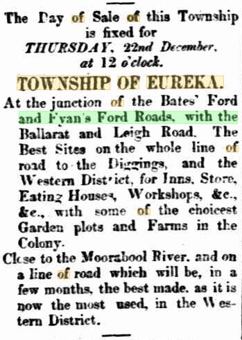
There is no mention of the new owner's name or whether the block even sold, but less than two months after the auction date, on the 1st September, a 420 acre chunk of the original 611 acre block was again up for sale either as one lot or subdivided into town allotments, (Geelong Advertiser and Intelligencer, 1st September, 1853). In his book The Stepping Stone: a history of the Shire of Bannockburn (1995), Derek Beaurepaire indicated that it was John Learmonth himself, who offered up the land as a prospective new town, bearing the name of Eureka:

Auction of the Township of Eureka (Geelong Advertiser
and Intelligencer
, 21st December, 1853)
The town would have, it was claimed, a reliable supply of fresh water and was more conveniently located (close to Geelong) than Meredith where blocks in that recently established township had been snapped up at prices well above the odds. The superior Eureka township it was claimed, was perfect for those wanting to establish stores, eating houses, workshops, farms - situated as close to the Moorabool River as it was - and even inns. The Ballarat Rd past the township was - if not quite yet - the advert claimed, soon to become the best made road in the colony by virtue of its being the busiest in the Western District.
Despite all the hype however, the sale was not a great success and no town developed at the junction. This may have been at least in part due to the fact that a significant proportion of the land in question was a swamp which was probably the main source of that "permanent" water, and whilst the Moorabool River was nearby, there was no access to it from the township. The area is labelled on the 1863 geological survey map as Learmouth's(sic) Swamp. The subdivided portions of land were situated to the north of the Ballarat Rd, opposite its intersection with the road from Fyansford and the non-existent township was labelled on the map as Learmouth (not Eureka).
Whilst a settlement may not have developed as planned, one establishment, built south of the Ballarat Rd in the point of the intersection with the road from Fyansford did: the Eureka Hotel. The first mention I can find of the hotel's existence is in the Geelong Advertiser and Intelligencer of 31st July, 1854 when James Wallace "begged to inform" the public that he had taken over as the proprietor of the "Eureka Inn". The implication of course, is that it was not Wallace who built the hotel and I have not so far been able to trace the original proprietor.
Small section of the 1863 geological survey map, showing subdivisions in the
"Township of Learmouth" and the Eureka Hotel, Image held by the State
Library of Victoria
Over the following years, Wallace's name appears in connection with the hotel on numerous occasions and on Wednesday 28th February, 1855, the block of land on which the hotel stood - being Portion 1 of Section 19 in the parish of Gherineghap - was put up for auction. It was described as "containing 179 acres, having a frontage of 4300 feet on the main road from Geelong to Ballarat via Fyansford, on the S.W., and 3790 feet fronting to the main road to Ballarat via Batesford, on the north". It would be auctioned "together with all the buildings and other improvements thereon" (Geelong Advertiser and Intelligencer, 19th February, 1855). A second block of 233 acres immediately to the east was also for sale. Interestingly, there is no mention of the hotel itself in the advertisement.
Meanwhile, business at the Eureka continued, often it seems, in the rough and ready fashion of the day. On 19th February, 1856 according to the Geelong Advertiser and Intelligencer, Wallace was in court having charged four of his patrons with brawling in his hotel. The men were, he stated, travellers whom he had served a small amount of alcohol. Also at the bar having a drink was a carrier returning from a delivery at Meredith. All seemingly normal for an hotel on a public highway - except that the carrier (John Gilloghan) was mounted on his horse which, being of a quiet nature, he had chosen to ride into the premises. After sharing a drink, or perhaps two, a fight broke out with the four travellers wielding fence palings and glass bottles as Wallace attempted to eject them. In the affray, Gilloghan was hit over the head with a bottle, receiving lacerations.
Upon hearing Gilloghan's evidence, the Mayor who was presiding at court that day, observed that "it appeared rather extraordinary that [Gilloghan] should visit public houses on Sundays in this manner, by exhibiting his horsemanship within the rooms of the hotel." Sunday trading was of course, not permitted, unless the publican was serving those travelling long distances, hence no doubt Wallace's desire to show that he had only served small amounts of alcohol to permitted patrons.
Image of Dr Alexander Thomson taken from Wikipedia
In their defence, the lawyer for the travellers argued that the travellers wanted to fine Gilloghan for entering the bar on horseback and observed in any case, that he had been drinking with them before the fight occurred.
In making his judgement, the Mayor observed that "it was nowise attributable to forbearance on the part of Ross [one of the four] that he had not murdered the man [Gilloghan]." He also noted that "they had all been engaged on a Sunday afternoon in a most disgraceful disturbance, and he should fine them each 40s, with instructions to the Inspector of Police to take out a summons against Mr Wallis(sic), to answer for breach of the Licensing Regulations." Case dismissed!
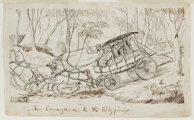
On a more sombre note, the Eureka Hotel - or more properly its proprietor - was once again in the news when, on a dark, July night in 1856 the evening coach from the diggings in Ballarat arrived to make its final change of horses for the journey. The Eureka was a regular stopping place for the Estaffette line of coaches. Either the first or last stop on the road, depending on the direction of travel. While the horses were changed for fresh ones, passengers could take a break and perhaps have a meal or a drink before continuing their journey. On the night of the 26th July, the coach arrived as usual, changed horses and prepared to depart after only a short stop. At least one of the passengers went inside for a  "negus of wine" (a spiced, sweetened wine served hot), no doubt to keep out the chill of a July night on the Ballarat Rd.
Knowing that the track ahead was none too good, the publican Wallace, offered to lead the way on his own mount, carrying a lantern to light their path.
An Estaffette coach attempting a creek crossing on its way to the diggings, in
1854. Image by Charles Lyall, held by the State Library of Victoria
Despite this precaution, when the coach was between half a mile and a mile beyond the Eureka (probably somewhere near today's Buchter Rd), it struck a stump and before anything could be done, it overturned. Of the 13 passengers inside the coach, none suffered serious injury. A 14th passenger, riding on the box beside the driver was not so lucky. As the company sorted themselves out, it became apparent that Thomas Robinson was seriously hurt. Whilst Wallace went on to Batesford for a doctor (Robert C. Hope from nearby 'Lynnburn' was summoned), the patient was made comfortable with cushions from the beleaguered vehicle, however within an hour, and before Wallace returned with Dr Hope, Robinson died. His body was returned to the Eureka, the site of his final drink, on a dray along with the others from the coach. The coroner was quickly summoned and the following day, an inquest was held before a jury of 12 where it was deemed that Robinson had died as a result of internal injuries sustained in the accident. No blame was attributed to the driver of the coach.
By August the following year and with business still reportedly booming, Wallace decided to sell up. This time, along with the land which now totalled 200 acres, the hotel itself was advertised:
Advertisement for the Eureka Hotel,
Ballarat Star, 3rd August, 1857
With coaches stopping night and day, not to mention those travelling on horseback or by dray, adequate stabling and a water supply for stock was as important as beds for the travellers so it is not surprising that the Eureka boasted such a large stable in addition to the hotel itself.
By November, the property had been sold and whilst I found no mention him in the newspapers, according to the publication Hotels, Pubs & Inns of the Geelong Country Districts (Pam Jennings, 2009), the new owner was Joseph Haughton who held the license from December, 1856 possibly until April, 1858 when the inn changed hands once again. By this time however, the hotel may have been becoming a little rundown. A traveller on the road in December, 1858 described the hotel as "a forlorn looking place" (Ballarat Star, 2nd December, 1858). Business however, continued and the next mention of the "Eureka Inn" in the media shows that Dennis Powell was granted a liquor license for the premises at the April, 1859 meeting of the licensing board.
Powell was an Irishman and a noted athlete amongst the local Celtic community. In January, 1859 after both competed successfully at the third grand annual gathering of the Comunn na Feinne, Powell accepted a a bet to face down a local Scotsman in a caber tossing competition at South Geelong. So confident was he of his ability that he claimed that he would "turn the caber better than any McIntyre!"
Finally, after a no-show on Powell's part and significant amounts of bragging and bluster on the parts of both men and their supporters, a date was set for the match up and the stakes raised to £20. One shilling entry was charged at the venue and a variety of activities occupied the assembled crowd. Powell won the toss of the coin and elected to throw second. McIntyre's first attempt was a no-throw as was Powell's. After some quick tweaking, the caber was trimmed to 13ft, 5in and the men threw again. This time, Powell managed a respectable 27ft, 11in throw, a target which could not be bettered by McIntyre after several throws and Purcell was declared the winner.  So impressed were his supporters that the following month, they purchased a chased silver cup which was presented to Powell at his hotel on 23rd February.
The 1863 Highland Gathering at the Comunn na Fienne reserve, South Geelong
(located on Swanston Street between Balliang and Foster Streets) only four
years after the competition between Powell and McIntyre
In contrast to his athletic prowess, Powell's success in business does not seem to have been so great. By May he was advertising the land surrounding the hotel to let as the "Eureka Estate" consisting of between 400 and 500 acres, 200 of which were fenced. In July, the hotel itself was put up for auction, described this time as containing 20 rooms and standing on a little over 10 acres of land. It did not sell however, and in February, 1860 Purcell again put it up for sale.
By August, things were becoming desperate for Powell, as his estate - including the hotel - was placed under sequestration. Finally, in September, a new proprietor was found and Thomas Newby took over the license for the hotel.
In what was becoming an all too familiar pattern however, Newby was offering the Eureka up for lease by September, 1861 and by December, the license had been taken up by Thomas Harris. In November, 1862 it was once again up for auction with the furniture and other goods and chattels to be auctioned off in January the following year.
The purchaser this time was James Appleton, a furniture broker and valuator from Little Ryrie St, Geelong who promptly put the hotel back on the market in March, 1863 looking for a "cheap sale". I suspect he may have purchased the furniture to sell through his business, hoping to make a quick sale on the property as well, since at the same time as he was attempting to sell the Eureka he was also selling the Royal Charter Hotel (now the Carrington/Centra Hotel) in Geelong.
If so, he was not immediately successful in selling the Eureka or he had a change of heart and at the April liquor licensing board meeting, he applied for a license for the hotel. After an adjournment of a fortnight however, his application was "Refused, the house not being in good repair."
And this it seems, marked the end of the road for the Eureka Hotel on the Ballarat Rd. From 1865 the property was advertised as "Eureka Paddock" and as quoted in my previous post on the Friend in Hand Hotel located a short distance up the road to Fyansford, a contributor to the Geelong Advertiser of 22nd March, 1866 observed sadly that "the old landmarks on the Ballarat road are gradually disappearing. The old Friend-in-Hand is closed up; where the Eureka used to stand is now a mere waste, honored now and again by being made the camping place of a solitary teamster."
Looking south east from the intersection of the Fyansford-Gheringhap Rd and
the Midland Highway, October, 2016. No visible sign of the hotel remains
This would seem to suggest that perhaps the buildings were no longer standing, however there is no mention of a sale of building materials which usually occurred with a demolition. Additionally, there was one mention in 1868 at an inquest that the deceased had "also had a drink at the Eureka" (after previously stopping at Batesford), so maybe the hotel lingered on for a few years longer, although perhaps without a license.
Throughout the 1870s, the "Eureka Paddock" (now 225 acres) passed to James Connolly who sold it in September, 1878. In August, 1879 it was for sale with inquiries to be directed to Mr J.L. Price of Geelong and then, on 25th June, 1880 a final auction notice appeared in the Geelong Advertiser indicating that the "Eureka Paddock" consisting of 225 acres, 2 roods of "first class grazing land" was for sale, along with a "substantial well-built six-roomed house, a three-roomed cottage, a three-stalled stable, harness room, coach-house and hay-house". The land boasted a permanent water supply and was contained within a post-and-rail fence and a stone wall. Who built the house, when or why it was built or what became of it, I do not know, however today, there is no sign that any structure stood upon the block, let alone a 20 room hotel, with a 20 stall stable and numerous outbuildings.

05 May, 2016

Just what the doctors ordered!

A few weeks ago I wrote about the Hope family of 'Darriwill' and 'Lynnburn' on the Moorabool River near Batesford. To recap, the brothers Robert, George and James travelled overland from Sydney, arriving in the district in 1839. During the mid 1840s as land along the Moorabool River and Sutherland's Creek was opened up for sale, the Hopes took the opportunity to purchase several thousand acres of land and took up leases for thousands more.
In addition to their acquisitions in the Moorabool Valley, the brothers looked further afield. In 1851 they took up the lease for the Native Creek No. 3 squatting run immediately to the east of the confluence of the Barwon and Leigh Rivers. The 4,000 acre property extended to the east of the Native Hut Creek and south across the Barwon. To distinguish it from the two similarly named runs to the north, it was also known as the Barwon Native Creek or Leigh's Native Creek Run and even Native Creek (Teesdale).
Native Creek No. 3 during Dr Robert C Hope's time, 1857. Image held by the
State Library of Victoria
The run was originally taken up by Thomas Learmonth on behalf of the Derwent Company in 1837, however within a few years the Learmonths moved on to Buninyong and the leasehold was transferred to Charles Lambert Swanston and his son-in-law Edward Willis who as the last remaining members of the Derwent Company, held it from 1842. In 1850 following the collapse of his Derwent Bank and with significant personal debt, Swanston died. within weeks of Swanston's death, Willis placed the Native Creek No. 3 leasehold with stock and various other properties on the market. By early February, 1851 the Hopes had taken up the lease.
On the opposite - west - bank of the Leigh River to the Hope's new station, a blacksmith named William Lawson had built an hotel in 1843. Lawson's Horseshoe Inn was located on the neighbouring Weatherboard Run - held by the Derwent Company - at a convenient fording point between Native Creek No. 3 and Weatherboard. Within years, others settled in the area and the township of Inverleigh soon sprang up, with the first land sales being held on 5th December, 1854. Robert Hope was amongst the first land purchasers in the newly formed town.
During 1855 and 1856 the Hopes also began to buy the land they had previously leased as part of their Native Creek No. 3 Run, with Robert's name appearing on the titles.  In the parishes of Murgheboluc and Carrah, north of the Barwon he purchased around 25 blocks of land, comprising almost 4,200 acres. The blocks ranged in size from the 640 acre pre-emptive selections in both parishes to several 14 acre blocks on the outskirts of Inverleigh. The land was divided roughly down the middle by Native Hut Creek and included over 1.6 miles (2.6km) of Barwon River frontage west of its confluence with Native Hut Creek.
Extent of land purchased by the Hopes at Inverleigh outlined
in red
South of the Barwon, an even greater expanse of land was purchased at around the same time. Thirty-six blocks, totalling almost 6,900 acres extended into the parishes of Carrung E Murnong and Gnarewarre and expanded the property well beyond the original 4,000 acres. By the 1870s the Hopes had chosen the name 'Barwonleigh' for their purchased estate, so-named for its position near the confluence of the Barwon and the Leigh Rivers.
At the same time as they purchased the land which comprised 'Barwonleigh', the family also invested in the local community. On the north bank of the Barwon, somewhere near the middle of the river frontage, Robert Hope built a flour mill. According to an article in the Geelong Advertiser of 10th December, 1856, it was a watermill which was fed from a channel almost one mile long, stretching back up the Barwon [to the edge of his property]. The article spoke in glowing terms of the benefits the mill would bestow on the surrounding districts and described it as one of the largest and most powerful in Victoria.
Carrah Flour Mill
The mill soon became known as the Carrah Flour Mill, named presumably for the civil parish which encompassed Hope's run. Robert however was a doctor, not a miller and by early 1859, tenants had been installed to run the mill. On 26th February, the following advertisement appeared in the Geelong Advertiser:
NOTICE--To the Farmers of the Colac Road, Mount Pollock, Gnarwarre, and Modewarre district--Wilson and Elliot, of the "Carrah Mills" (Dr Hope's station), Inverleigh, beg to inform the farmers of the above district that they have completed their bridge over the Barwon, close to the mills, and are buyers of good wheat at the highest market price.
Wheat stored for grinding free of charge.
Whilst Elliot sold out of his part of the business in 1863, his partner Wilson continued to run the mill for a further ten years until 1873 when he in turn sold to David Reid, an experienced miller who already operated a mill in Belmont who was to take over operations from 1st October.
It is probably worth remembering that at around the same time as the Carrah flour mill was under construction, a second mill on the banks of the Moorabool River opposite Robert's 'Lynnburn' property was also in the process of erection, serving a similar purpose for the people of that region.
Robert it seems, lived with his family on the Native Creek Run for several years. Shortly after his arrival, a son - James - was born at "Leigh" in October, 1851, however the child died only a few weeks later and was buried at the Eastern Cemetery; the earliest burial in what became the family plot.
Plaque on the Hope family grave, Eastern Cemetery, Geelong
Over the few years during which the family lived on the Native Creek Run, Robert also provided his medical services to the community when required, however he did not remain long in the district as by the mid 1850s, construction of his substantial homestead at 'Lynnburn' was complete and the family now divided their time between the property at Batesford and Robert's business interests in Melbourne. He did however retain ownership of 'Native Creek No. 3' and eventually, upon his death in 1878, the property passed to his son Dr Thomas Culbertson Hope.
Robert and Catherine Hope's plaque on the family grave
The Hope family grave, Eastern Cemetery, Geelong
Like his father, Thomas was a medical practitioner and divided his time between his medical practice and his property in addition to a number of community roles. In 1876 he was elected to the Bannockburn Shire Council, served as a justice of the peace and also as a manager of the Inverleigh and Teesdale United Farmers' Common.
I am unsure how much time the Hopes spent in residence at 'Barwonleigh' as opposed to their other residences, however the original homestead - a four-roomed bluestone structure - is believed to have been built around 1851 and extended over the years to include 15 rooms plus a ballroom built in 1919. In 1886 however the Barwonleigh Estate which had been in the family for almost 35 years was sold when Thomas moved to Geelong and then Melbourne to concentrate on his medical career. On Tuesday, 23rd March a gathering of local citizens was held at Warrington's Inverleigh Hotel to provide a fitting send off for the esteemed doctor.
Following the Hope's tenure at 'Barwonleigh', the property passed through a number of hands, beginning with Lewis Robertson who then sold the property within a few years to brothers WC and JR McCracken. By November, 1892, the property was again on the market but appears instead to have been leased to John Calvert whose lease expired in 1897 when the property sold to Dr Harry Leigh Atkinson, a practitioner from Bendigo. Harry - a Scottish immigrant - was an innovator in the use of plaster of Paris to treat broken bones and also contributed to other areas of medical practice.
In addition to his medical interests however, he was also an investor - in the local gold mining industry as well as in property. Despite extensive land purchases however, Harry - unlike the Hopes who tended to occupy their properties - remained living in Bendigo, preferring instead to install managers to run his vast estates.
At the time of purchase 'Barwonleigh' was said to include 8,200 acres of freehold land, however Atkinson significantly increased the size of the property, adding a further 16,000 acres of land - originally part of the Austins' holdings, stretching almost to the outskirts of Winchelsea. During his ownership, he left the day to day operation of the property in the capable hands of his son-in-law Alfred Featherstonhough Kelly who with his wife Amelia - Atkinson's eldest daughter - lived on and managed the property until Alfred's death on 9th December, 1915.
Shed near the riverbank at 'Barwonleigh', November, 2014
Dr Atkinson himself had died only a few months earlier on 14th July and as is often the case, a protracted legal challenge ensued between surviving family members over the distribution of his estate. In a legal stoush to rival the best of them, his children placed a caveat on their father's will when their step-mother (Harry's fifth wife) attempted to apply for probate. Finally, after proving that their father was not of sound mind when he changed the will in his wife's favour only a month before his death, his children won the day.
The end result - which would not have been too different for 'Barwonleigh' itself had probate been granted - was that the majority of the land was broken up into smaller farms by the Closer Settlement Board and sold off. The remaining 7,700 acres passed to Amelia Kelly - widow of Alfred - who once again expanded the property, this time by around 2,000 acres.
Amelia lived the remainder of her life at 'Barwonleigh' until hear death at the age of 88 in 1959 after which the property passed into the hands of her daughter Margaret and son-in-law Reginald Campbell.
On 1st March, 1965 disaster struck when the homestead was burnt to the ground. Only a small section of the original building including one room survived. The following year however, the Campbells opted to rebuild, adhering as closely as possible to the original plan.
'Barwonleigh' 1977 after rebuilding. Image courtesy of the John T. Collins
Collection, State Library of Victoria
Today, 'Barwonleigh' remains in the Campbell family, with the present incumbent - Duncan Campbell - being the 7th generation of the family to own the now 2330 ha (5760 acre) property which he runs as a mixed farm, with his wife Maxi, breeding sheep, cattle and pigs as well as cropping canola, wheat, barley and faba beans.
And it would seem likely that the future of the estate may be secure for some time yet with a further two generations of the family already assured and who - if they choose to take over the reins - will become the 8th and possibly 9th generations to take the helm.
One final consideration is of course the fate of the Carrah Mill. There is no mention of it in the newspapers past 1874 when David Reid took up the lease and it seems likely that it suffered the same fate as many small mills across the country as cropping trends changed and technology moved on.
Today, the remains of the mill building constructed by Robert Hope on the north bank of the Barwon, stand as a striking ruin against the skyline, but are no longer a part of 'Barwonleigh'
Ruins of the Carrah Flour Mill built in 1856 by Dr Robert Culbertson Hope.
24th April, 2016. Click to enlarge


04 April, 2016

Making tracks: the Colonel and the one-armed shepherd

With the advent of the gold rush in 1851, diggers flocked to the goldfields of Ballarat and surrounds. In previous posts I followed their path from Geelong via the Geelong-Buninyong Rd and the track from The Leigh (Shelford) to Buninyong. In addition to these routes, there was also a third option, one which a hopeful real estate agent in the Geelong Advertiser and Intelligencer of 13th October, 1853 claimed was "the best line of road to Ballarat, Canadian Gully, Jeweller's Flat & c".
The road in question lay to the east of the Geelong to Buninyong Track, following a similar line to today's Steiglitz Road. After cresting Bell Post Hill, the route led towards Batesford, but instead of following the main road down into the Moorabool Valley, those wishing to take the other road to the east, took the track towards Steiglitz. Other than the above advertisement however, there is little mention of the route before October, 1855 when Steiglitz became a significant destination of its own. According to the Geelong Advertiser and Intelligencer of 16th October, 1855:
The shortest road from Geelong [to the new goldfield at Steiglitz] is to pass Colonel Kelsall's Station, cross Sutherland's Creek, follow the well defined dray road to the left of the creek till you come to the old shepherd's hut, when you are within two and a half miles from the diggings, which are situated on a point or tongue of land between Sutherland's Creek and a tributary creek flowing from the Anakies.
Sounds simple enough, but who were the Colonel and the shepherd?
The colonel was Roger Kelsall, engineer, sailor and then squatter who, according to fellow squatter Thomas Manifold, arrived in the district in the spring of 1836 and took up land on the upper parts of Sutherland's Creek. Prior to his arrival, Kelsall served as Clerk of Works at Port Arthur and was responsible for the design and construction of several of the buildings there. It was not however, until 1845 that he sold his commission with the Royal Navy and retired to Victoria. During this time I believe his run on Sutherland's Creek was maintained for him by a manager named Sharp.
The grave of Colonel Roger Kelsall, his wife Ann and son Roger
at the Eastern Cemetery
 By December, 1854, Kelsall had converted part of his lease into 1,490.5 acres of purchased land - including his pre-emptive right of 640 acres. The latter lay nestled between the left and right branches of Sutherland's Creek down to their confluence, with the rest of the land in several blocks on either side of both branches branch. He gave this property the name 'Chesterdale'. Additionally, the Colonel also purchased 557 acres of land lower down Sutherland's Creek on the west bank, directly opposite the Hope's land. This property, 'Strathey', eventually extended to 1,100 acres by the time both properties were subdivided and sold in 1908. Until that point, they had remained in the hands of the Kelsall family, however not long after the death of the Colonel in 1861, they were leased out to local graziers.
Contrary to the above description of the route, a look at the survey maps shows that the diggers would first have crossed first through the Hope's 'Darriwill' property before crossing the creek onto Colonel Kelsall's 'Strathey' and joining the bullock track. The creek crossing was presumably near the site of today's Hope's Bridge on the Steiglitz Rd. Clearly, the current bridge is not the original, that bridge stood slightly upstream of the modern one. The concrete and bluestone buttresses of the old bridge and various related timbers can still be seen just north of the existing bridge.
Looking upstream at the abutments and some remaining timber and concrete
at the site of the original Hope's Bridge
The earliest mention I can find of a bridge at this site is 1863, when drains were installed on the nearby road. In 1865 when the decking timbers were being replaced, it was discovered that the timbers beneath were rotten and in need of attention, indicating that the bridge had probably been in existence for some years at that time. Other timber bridges I have researched seem to have had a lifespan of around 10 years before structural timbers needed replacing, which might indicate that the bridge dated back to the 1850s. As far as I can tell, two bridges were erected on the Steiglitz Rd. One in 1857 and one in 1858. The latter was on the "Approach to Steiglitz gold-field" so perhaps this was the erection of the Five Mile Bridge, much closer to Steiglitz, whilst the bridge built in 1857 was at the crossing between Hope's and Kelsall's - but that is speculation. Whether an earlier structure such as a ford existed at the site, I don't know.
Looking east across Sutherland's Creek and the original Hope's Bridge
towards 'Darriwill'
After crossing the creek and making their way through Colonel Kelsall's property, it was - according to the above article - a simple matter of following the dray road on the left of Sutherland's Creek, towards the diggings. Other than the above reference however, I can find no mention of a road to Steiglitz before November, 1855, but presumably the dray track mentioned, led originally to the Durdidwarrah squatting run of Charles Augustus Stieglitz.
Another description of the trip to the new goldfield at Steiglitz which appeared a few months later in the Geelong Advertiser and Intelligencer, 28th January, 1856, was perhaps not quite so flattering, but provided a little more detail about the route:
"the road from Geelong to Steiglitz leads, for the first ten miles, through an open and slightly undulating country, the aspect of which is, of course, monotonius(sic) enough. Passing this space you arrive at Sutherland's Creek, now a chain of waterholes not particularly limpid. Next comes a tract of thinly timbered land, terminating in an open piece of rising ground known as the Bald Hill. Beyond this point and within eight miles of the "diggings," you pass in a close succession three refreshment tents, recently pitched, and a weatherboard establishment of a similar character not yet completed. A mile or two further on you find yourself suddenly in the gold country. The rapidity of the transition here is very remarkable. The easy undulations of the soil which prevail in the early portions of the journey give place at once to short and abrupt hillocks, pretty well timbered, and sprinkled over with great quantities of grass...
Being summer, it seems that there was little water in the creek. I can find no other mention of the "Bald Hill", however from context would expect it to be somewhere near what would (by 1856) become the township of Maude. At this point it is also worth remembering the "Buninyong Road from Melbourne" - described in my post "All Roads Lead to the Green Tent" - which intersected the Geelong to Buninyong Track at the Green Tent. This east-west track dating back to the 1840s, also crossed the track to Steiglitz, probably at Thompson Rd, Maude, as evidenced by an 1857 survey map which marks this road as "towards Melbourne". For those not wanting to make the steep climb in and out of the Moorabool Valley at this point, the Steiglitz route provided an alternative for those travelling from Melbourne.
From November, 1855 however, Steiglitz itself became a destination with the discovery of extensive gold reefs, making the track from Geelong even more popular.
Remaining brickwork footings of the United Albion Mine, Steiglitz
Not surprisingly, the sudden increase in traffic heading up the Steiglitz dray road resulted in the establishment of a "close succession of refreshment tents". They were probably similar to those which sprang up on the Geelong-Buninyong Track in the earliest days of the gold rush to Ballarat.
As far as I am aware, prior to the rush to Steiglitz there was no public house between Batesford and these new diggings.
Within a very short time however, that changed. In addition to the "coffee tents", an array of traders scrambled to set up shop in Steiglitz. According to the Geelong Advertiser and Intelligencer, by the first week of January, 1856, tents and stores were popping up by the dozen. As well as the essential butchers, bakers and general stores, hotels were quickly established. Upcoming applications for new liquor licenses advertised in February, 1856 included five for Steiglitz and a further two for Sutherland's Creek, all no doubt capitalising on on the traffic heading up the dray track to the goldfield.
Once past the "coffee tents" as noted, the terrain changed and became more rugged, signalling the presence of auriferous ground. From the turn off to Melbourne, the track fell away, down to a second crossing of Sutherland's Creek, this time at Five Mile Bridge and it was here, several newspaper accounts indicated, that the "one-armed shepherd's hut" could be found. Various reports shared around the colony, stated that a gold reef had been struck near the one-armed shepherd's hut, after crossing Sutherland's Creek, about 20 miles from Geelong.
The bed of Sutherland's Creek. During the 1850s numerous gold mines
operated along the banks of the creek
But who was the one-armed shepherd? Well, despite my best efforts, I have not been able to discover a name. In addition to his hut being a common point of reference on the road to Steiglitz, it was reported that on 21st January, 1856 he was the victim of a robbery, when three armed men known to be from the nearby diggings invaded his hut. Neither his name, nor indeed his presence at the time of the robbery, were not mentioned.
Once past the shepherd's hut, it was only a matter of a few more miles to Steiglitz, if that was the digger's intended destination; and for many, from October, 1855 it was. By December that year, a coach was running from Geelong to Steiglitz, carrying those who could afford it. In fact, within a short space of time, Steiglitz became a staging post for the coaches running to and from Geelong and the goldfields.
The view down Regent St towards the site of Cobb & Co.'s
staging post (left), April, 2010
But Steiglitz was not the end of the journey for every digger. Indeed, prior to October, 1855 it was just another creek crossing on the way to Buninyong, and later, Ballarat. It was also roughly the half way point on this eastern path to the diggings and according to some, was crying out for a public house; a stopping point along the road, where the drays carrying supplies to the goldfields of Ballarat and Buninyong and a little later to places such as Mt Wallace, Mt Egerton, Dolly's Creek and Morrisons, could spend the night or break their journey with a meal.
That need was filled in April 1853, when Richard Coombs announced that he had purchased the mansion until recently owned by Charles Von Stieglitz and converted it for use as an hotel...

28 March, 2016

Branching out: 'Lynnburn'

As I explained in my previous post, diggers heading to the goldfields of Ballarat (and later Steiglitz), passed through land first occupied by Europeans in 1836; by John Cowie and David Stead at Bell Post Hill and by the Manifold brothers who arrived at a similar time and took up the land either side of the Moorabool River from its confluence with Sutherland's Creek, down almost to Fyansford. The Manifolds remained in the district only until December 1838. In 1837, they leased some of this land along the Moorabool to brothers John and Henry Bates who ultimately gave their name to the town of Batesford which prior to this had been known as Manifold's Ford and even Hopeton. By 1839 however, the Bates had also moved on, leaving only their name behind.
By the time of the gold rush however, this district was within the boundaries of closer settlement, meaning the squatters had long since moved on and the land was in the process of subdivision and sale.
Amongst those who took advantage of the push to open up new land for settlement, were the Hope brothers George, James and Robert. As described in my last post, by 1856 George Hope was establishing himself on Sutherland's Creek and along the Moorabool River at 'Darriwill', on land originally purchased by his brother Robert. At about the same time however, Robert himself was building a house of his own further downstream on the Moorabool below Batesford on land originally purchased by George. He called the property 'Lynnburn'.
Looking across the Moorabool River towards 'Lynnburn', November, 2015
Gazetted in April, 1846 and purchased by George at land sales in June of that year, the land consisted of 734 acres incorporating lots 9 and 10 of the Parish of Moorpanyal. These blocks, which straddled the Geelong-Buninyong Track, included the present site of Batesford east of the Moorabool River and incorporated river frontage from Batesford downstream to the present Batesford Quarry. It wasn't long however, before the more northerly part of the estate was subdivided and sold off in smaller allotments as part of either the Batesford township or the "Hopeton Estate" as advertised in the Geelong Advertiser of the 21st February, 1851.
The house built for Robert on the remaining land, was constructed from stone quarried on the property and is described on the Victorian Heritage Database as a "single storey squared basalt residence with double bay front, slate roof and two storey rear kitchen wing and encircling verandah, now demolished". It is thought that the architect responsible for the design was Walter Sheridan.
'Lynnburn', image taken from the Victorian Heritage Database
Like his brother George, Robert also planted grapevines and in 1864 in anticipation of substantial harvests, was in the process of building a three-storey building incorporating a cellar, fermenting rooms and a wine house. From the description, the building was set into the slope of the hillside descending to the river, with the 27 acre vineyard located between the house and the Geelong-Ballarat Rd overlooking the river.
In addition to the substantial cellar, Robert, along with his brothers, also had a flour mill erected at the water's edge. The mill was constructed of bluestone and located on the west bank of the river, south of Batesford - presumably on land purchased from the Port Phillip Association who by then owned the land along that part of the west bank. The mill was linked to the rest of the property on the east bank by a small footbridge. Most of the year, it was powered by a large waterwheel, with steam used approximately three months of the year when water levels were too low.
Early image of Hope's Flour Mill showing footbridge and additional outbuildings.
Image from the Wynd Collection, Geelong Historical Society
The mill was destroyed in 1880 when the Moorabool suffered major flooding which was said to have left around 50 people in Batesford homeless. It was mentioned at the time of its destruction, that the mill had stood for 23 years, giving a construction date of around 1857. This concurs with family documentation held by the Hope descendants which show the purchase of the land on which it stood in 1856 (The flour mills of Victoria 1840-1990: an historical record, Lewis and Peggy Jones, 1990).
Hope's flour mill on the bank of the Moorabool River, c1880. Image held by
the State Library of Victoria
Unlike his brother George, Robert Hope used 'Lynnburn' as his country estate and was not in permanent residence. By 1875, Charles Craike was operating the vineyard and was living at 'Lynnburn' with his family. Little did he or any of the Hope brothers realise however, that within a few short years, the Australian vine stock would be blighted by the arrival of Phylloxera - a small, sucking insect related to the aphid which attacks the roots and leaves of grapevines, causing growth deformities, depriving them of nutrients and rendering them susceptible to disease.
Phylloxera first made its appearance in Australia at Geelong in 1877 and according to the newspapers of the day, by 1879 there were signs of Phylloxera in the vineyard at 'Lynnburn'. In a move to control the outbreak of the pest, all vines within a certain distance of infected properties in the region were pulled up and an ongoing process designed to remove any remaining roots was implemented. What had been a thriving industry was brought to a standstill. By 1885 when moves to replant were afoot, remaining root samples from 'Lynnburn' revealed that the insect was still present in significant quantities in the soil.
In 1881, 'Lynnburn' was put on the market, however Craike seems to have remained at the property for several more years before Jacob Deppeler - a Swiss vigneron - took up residence, possibly in 1883. The property remained in the Deppeler family until 1954. Vines were eventually reintroduced and wine was again produced in addition to other pastoral enterprises.
Looking east across the Moorabool Valley to a modern vineyard on what was
'Lynnburn' land
Over the years, the size of the property has reduced and when 'Lynnburn' was sold most recently in April, 2015, the area was advertised as a little over 66.5 hectares (or 164.5 acres), less than a quarter of its original size, but retaining around 1.5 km of river frontage south of Batesford. In the preceding five years, the entire property, homestead included, had been returned to some of  its former glory with a program of weeding, fencing and soil-improvement to restore the land as well as refurbishment and repair of the house itself. Before sale in 2015, it was estimated that the property would sell for between $4.5 and 5.5 million.

24 March, 2016

Branching out: 'Darriwill'

Before I look at the third route from Geelong to the goldfields of Ballarat and beyond, I think it might be helpful to look at a little of the history of some of the properties through which the track passed. This route ran via Steiglitz, but for the first few miles of their journey, those following it would have used the same road up Bell Post Hill, towards Batesford used by those following the Geelong to Buninyong Track.
Before descending into the Moorabool Valley however, they took the turn off for Steiglitz, which led them over Sutherland's Creek and onto the high ground between the creek to their east and the Moorabool Valley further to the west.
In the earliest days of European settlement the land either side of the Moorabool river below Sutherland's Creek down to Fyansford was occupied by the Manifold brothers. Above the confluence of Sutherland's Creek with the Moorabool, the land was occupied by Joseph Sutherland. According to fellow squatter Thomas Manifold, Sutherland took up the land in 1836. Joseph was a Scotsman and amongst the earliest settlers in the Port Phillip District. The only other information I have been able to discover, indicates that he was on his Sutherland's Creek Run at least during 1842-1843, but soon moved on to more distant pastures.
By 1846 three brothers - Robert Culbertson, George and James Hope - who had travelled overland from New South Wales began to lease and purchase large tracts of what had been the Sutherland's Creek Run of Joseph Sutherland and some of the land occupied by the Manifolds. In June, 1846 George purchased 734 acres of land along the Moorabool River at Batesford and according to deeds dated November 1847, Robert purchased almost 2,000 acres of land to the north along either side of Sutherland's Creek. Further, in September, 1848, James and George were granted a licence to depasture stock in the same area on the Moorabool.
The Moorabool River at Baker's Bridge in 2011. The river at this point formed
part of the boundary of 'Darriwill'
In April, 1849 Robert was granted the lease of around 2,000 acres under pre-emptive right in the parishes of Darriwill and Yowang and by 1850 his application to lease land had increased to include 8,720 acres in the parish of Yowang - presumably in addition to his freehold land. As well as his pastoral pursuits, Robert was a practising medical doctor and on 21st January, 1848, he was appointed coroner for the District of Geelong. In November, 1856 he was returned as one of five members representing the South Western Province in the Legislative Council of Victoria, holding office until August, 1864. In April, 1867 he was again elected to the same seat, holding office until 1874. During his time in parliament he was known for his very conservative views. A staunch advocate for the rights of the landed classes, he fought fervently against any move to limit their privileges or to allow selectors the right to choose land already leased from the crown by the squatters.
By contrast, brother George appears to have concentrated more on establishing the family property. Survey maps show that in 1854 he purchased more land adjoining those blocks bought by Robert in 1847, bringing the total freehold owned by the Hopes to over 4,000 acres along the east bank of Sutherland's Creek between today's Robbs Rd to the north and Lovely Banks Rd to the south.
Having purchased substantial acreage, the Hopes no doubt felt secure enough to begin building and making permanent improvements to their property which they called 'Darriwill'. In 1856, they built a single-storey, bluestone house to the design of John Young, with later additions - including a cellar - designed by prominent Geelong architect J.L. Shaw (The Stepping Stone: a History of the Shire of Bannockburn, D Beaurepaire, 1995).
'Darriwill', image taken from the Victorian Heritage Database
According to the Victorian Heritage Database, this was the residence of George who established a substantial vineyard on the property in addition to running sheep. Hope's winery was described in a glowing article written by The Age on 7th March, 1864, which also made the surprising observation that the property, in outline, had the appearance of a bat.
1878 survey map of Yowang and Darriwil Parishes overlaid on Google Earth,
with an outline showing the land purchased by the Hopes
By October, 1878 under George's guidance, 'Darriwill' had grown to 4,768 acres. He lived at the property for the remainder of his life, dying on 25th April, 1884 at the age of 69. The property remained in the family, administered as per the terms of George's will by a trust administered by his wife Marianne and eldest son James. Over subsequent years, the names of his sons George Rowland and William Waugh Hope also appeared in connection with the property.
In 1909 however, the majority of the property (3335 acres) was subdivided into 26 lots of varying sizes which were then auctioned off, leaving only around 700 acres of the original land along with the homestead, in the hands of the family. The remaining land and assets continued to be run by a family trust up to and following the death of James (1903) and Marianne (1911). Isabella, the unmarried daughter of George and Marianne, lived at 'Darriwill' until her death in 1939 after which, the property was distributed according to the terms of her will amongst the family. In 1941 however, the original homestead and 700 acres were bought at auction by her nephews - George Rowland's sons - thus retaining the property in the family.
Photos of Marianne and George Hope along with their daughter Isabella. Image
held by the State Library of Victoria
Also in their hands was the neighbouring property 'Darriwill North'. How or exactly when the family took possession of the property, which formed part of the original land purchased by Dr R.C. Hope in 1847, I have not discovered. It was here however, following the death of her husband George Rowland Hope in 1920, that his widow Agnes was responsible for the construction of a second home in 1925. This house, designed by Geelong architects Laird and Buchan, was a single storey, brick building in the Californian Bungalow style commonly constructed between the two World wars. Further extensions were added two years later in 1927. Agnes, lived at the property until her death in 1955.
Photo of 'Darriwill North' taken in 2008 (Stan Lawrence Real Estate Pty Ltd)
'Darriwill North' remained in the Hope family until 2008 when Alistair Hope (great grandson of the original settler) and his wife Ellen, finally sold the property, thus ending nearly 170 years of occupation and ownership by the Hope family at Darriwill. The house remained on around 268 acres of a total 1650 acres sold and in 2011 Darriwill North Holdings Pty Ltd was listed as a private company. 'Darriwill North' is now a registered stud, breeding both Dorper sheep and Kelpie dogs.
By contrast, 'Darriwill', including the original homestead, was only retained by the family until 1971 when, following the death of Rowland Hope on 9th November the previous year, it was sold to Sanford and Jane Nevile who retained the property until 1994.
Looking north along Sutherland's Creek from Hope's Bridge on the Steiglitz Rd.
The land to the right belongs to 'Darriwill North'
 At this time, the property, including 840 acres, was purchased by Dougal and Nellie Ramsay who extensively replanted the garden surrounding the house. The Ramsays also went on to establish the Darriwill Farm chain of retail stores and cafes throughout Victoria, developing the Darriwill name into a highly sought after brand.
In March, 2012 however, 'Darriwill' was once again on the market, advertised as including both a winery and olive grove, incorporating 966 acres of land. It was hoped that the property would fetch in excess of $10 million, however its eventual sale price fell short of this mark.