Showing posts with label Native Hut Creek. Show all posts

09 May, 2016

An Inverleigh Odyssey

This post is an opportunity to show some photos of a part of the Barwon River that not many people other than neighbouring property owners get to see.
Thirty years or so ago, I paddled down the Barwon River from Inverleigh to Pollocksford with my father, brother and a school friend. I remember it taking quite a bit longer than expected. The overly optimistic aim had been to reach Geelong, but it soon became apparent that this wasn't going to happen. I have vague memories of rapids, several near misses, one capsize (not me), some tricky portage and a looming old building set on a high point on the north bank of the river. I'd always wondered what it was.
Fast forward a few decades and with my trusty kayak in tow it was time to repeat my voyage down the Barwon from Inverleigh. Thanks to my blog research, I now knew exactly what the old building was and was keen to take a closer look. With perfect weather for a paddle, we (hubby and I) took to the water a little below Bell's Bridge at Inverleigh and headed down river.
Looking upriver to the confluence of the Barwon (left) and Leigh (right) Rivers
Barwon River about 1km below the confluence with the Leigh River
This first section as I already knew was an easy, unobstructed paddle to the confluence of the Barwon and Leigh Rivers and from there, a further 1km of clear, easy to navigate water to a small weir. From this point, things get trickier and are very dependent on the water level. When we paddled this stretch in the 1980s, there was some portage involved as well as rapids and some reasonably fast-flowing water, however this time the water level was significantly lower, meaning there were no rapids to paddle through and significantly more portage.
Section of columnar basalt near the riverbank, formed as lava cooled and
contracted causing fracture lines, probably around 2-3 million years ago
And the portage began below the weir with a roughly 1.5km section which was in general very shallow and contained lots of obstructions (mainly rocks and reeds), meaning long sections of portage or dragging through calf-deep water on slippery rocks, interspersed with short paddled sections of no more than 100m or so - if that. This would probably be easier with higher water levels, but would also involve rapids.
Looking downriver below the weir
Below the weir
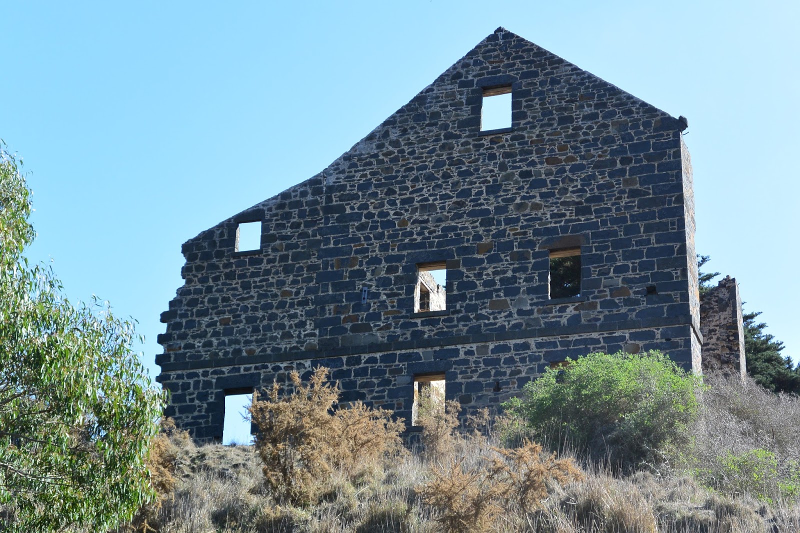
This led us to a relatively impenetrable section where we were required to drag up the bank and re-enter below down a steep-ish embankment through scrub. By that point however, we were in a wide pool situated immediately below the large building I'd remembered from my previous paddle. The building was of course - as discussed in my previous post - the old Carrah Flour Mill, built in the 1850s by Dr Robert Hope.
Looking across the river to the ruins of the Carrah Flour Mill
Carrah Mill from water level
From here, the river opened out into a wide, deep and easily paddled section for about 3.5km during which time it flowed north easterly down a long loop. There was little in the way of obstructions which made paddling simple.
Looking downstream below the mill
 At one extreme of the long loop was the confluence of the Barwon with Native Hut Creek, after which the river flowed around a sharp bend and back again to the south west.
The confluence of Native Hut Creek and the Barwon River, looking north
Below Native Hut Creek
Next it was back to another extended section of portage and rock-hopping between pools for around 1.5km before another navigable section of several hundred metres, then more portage, more paddling and so on for around 7.5km.
Some sections were easy
 Today, the land to either side is open grazing country, although current weather conditions and lack of rain means that the surrounding countryside is also very dry.
Grazing land, but not much feed to be found
More rocks...
...and more reeds...
Eventually, after around 16km of paddling and hundreds of metres of dragging over and around rocks, reeds and other obstructions and with the sun getting a little low for photography, we decided to call it quits at Murgheboluc and summon reinforcements to collect us. This was definitely a one way paddle!
Hubby taking his 'yak for a drag
It was also plan B. Our initial aim (which we knew was probably ambitious given the low water levels), was to push on all the way to the Pollocksford Bridge, however after six hours and what looked to be a significant amount of portage still ahead, we opted to stop at the access road which runs down to the river opposite the Murgheboluc recreation reserve.
A pretty pool before a large obstruction
By this stage, the river was quite overgrown and fortunately I'd thought to take a waypoint (GPS position) marking the location of the exit we needed. This was definitely a good idea as the bank at this point was relatively high meaning that the track was not visible from the riverbed.
Murgheboluc access track - like the sign at the road says "Please shut the gate"!
So all that remains now is to "paddle" a further 8km section of river from Murgheboluc to Pollocksford which promises to be similar to that immediately upriver. Hopefully this will happen sooner rather than later and more photos will be forthcoming in the near future. Whilst low water levels made hard work of this stretch of the river, it was still possible to get from start to finish, however it would certainly be quicker with higher river levels.

05 May, 2016

Just what the doctors ordered!

A few weeks ago I wrote about the Hope family of 'Darriwill' and 'Lynnburn' on the Moorabool River near Batesford. To recap, the brothers Robert, George and James travelled overland from Sydney, arriving in the district in 1839. During the mid 1840s as land along the Moorabool River and Sutherland's Creek was opened up for sale, the Hopes took the opportunity to purchase several thousand acres of land and took up leases for thousands more.
In addition to their acquisitions in the Moorabool Valley, the brothers looked further afield. In 1851 they took up the lease for the Native Creek No. 3 squatting run immediately to the east of the confluence of the Barwon and Leigh Rivers. The 4,000 acre property extended to the east of the Native Hut Creek and south across the Barwon. To distinguish it from the two similarly named runs to the north, it was also known as the Barwon Native Creek or Leigh's Native Creek Run and even Native Creek (Teesdale).
Native Creek No. 3 during Dr Robert C Hope's time, 1857. Image held by the
State Library of Victoria
The run was originally taken up by Thomas Learmonth on behalf of the Derwent Company in 1837, however within a few years the Learmonths moved on to Buninyong and the leasehold was transferred to Charles Lambert Swanston and his son-in-law Edward Willis who as the last remaining members of the Derwent Company, held it from 1842. In 1850 following the collapse of his Derwent Bank and with significant personal debt, Swanston died. within weeks of Swanston's death, Willis placed the Native Creek No. 3 leasehold with stock and various other properties on the market. By early February, 1851 the Hopes had taken up the lease.
On the opposite - west - bank of the Leigh River to the Hope's new station, a blacksmith named William Lawson had built an hotel in 1843. Lawson's Horseshoe Inn was located on the neighbouring Weatherboard Run - held by the Derwent Company - at a convenient fording point between Native Creek No. 3 and Weatherboard. Within years, others settled in the area and the township of Inverleigh soon sprang up, with the first land sales being held on 5th December, 1854. Robert Hope was amongst the first land purchasers in the newly formed town.
During 1855 and 1856 the Hopes also began to buy the land they had previously leased as part of their Native Creek No. 3 Run, with Robert's name appearing on the titles.  In the parishes of Murgheboluc and Carrah, north of the Barwon he purchased around 25 blocks of land, comprising almost 4,200 acres. The blocks ranged in size from the 640 acre pre-emptive selections in both parishes to several 14 acre blocks on the outskirts of Inverleigh. The land was divided roughly down the middle by Native Hut Creek and included over 1.6 miles (2.6km) of Barwon River frontage west of its confluence with Native Hut Creek.
Extent of land purchased by the Hopes at Inverleigh outlined
in red
South of the Barwon, an even greater expanse of land was purchased at around the same time. Thirty-six blocks, totalling almost 6,900 acres extended into the parishes of Carrung E Murnong and Gnarewarre and expanded the property well beyond the original 4,000 acres. By the 1870s the Hopes had chosen the name 'Barwonleigh' for their purchased estate, so-named for its position near the confluence of the Barwon and the Leigh Rivers.
At the same time as they purchased the land which comprised 'Barwonleigh', the family also invested in the local community. On the north bank of the Barwon, somewhere near the middle of the river frontage, Robert Hope built a flour mill. According to an article in the Geelong Advertiser of 10th December, 1856, it was a watermill which was fed from a channel almost one mile long, stretching back up the Barwon [to the edge of his property]. The article spoke in glowing terms of the benefits the mill would bestow on the surrounding districts and described it as one of the largest and most powerful in Victoria.
Carrah Flour Mill
The mill soon became known as the Carrah Flour Mill, named presumably for the civil parish which encompassed Hope's run. Robert however was a doctor, not a miller and by early 1859, tenants had been installed to run the mill. On 26th February, the following advertisement appeared in the Geelong Advertiser:
NOTICE--To the Farmers of the Colac Road, Mount Pollock, Gnarwarre, and Modewarre district--Wilson and Elliot, of the "Carrah Mills" (Dr Hope's station), Inverleigh, beg to inform the farmers of the above district that they have completed their bridge over the Barwon, close to the mills, and are buyers of good wheat at the highest market price.
Wheat stored for grinding free of charge.
Whilst Elliot sold out of his part of the business in 1863, his partner Wilson continued to run the mill for a further ten years until 1873 when he in turn sold to David Reid, an experienced miller who already operated a mill in Belmont who was to take over operations from 1st October.
It is probably worth remembering that at around the same time as the Carrah flour mill was under construction, a second mill on the banks of the Moorabool River opposite Robert's 'Lynnburn' property was also in the process of erection, serving a similar purpose for the people of that region.
Robert it seems, lived with his family on the Native Creek Run for several years. Shortly after his arrival, a son - James - was born at "Leigh" in October, 1851, however the child died only a few weeks later and was buried at the Eastern Cemetery; the earliest burial in what became the family plot.
Plaque on the Hope family grave, Eastern Cemetery, Geelong
Over the few years during which the family lived on the Native Creek Run, Robert also provided his medical services to the community when required, however he did not remain long in the district as by the mid 1850s, construction of his substantial homestead at 'Lynnburn' was complete and the family now divided their time between the property at Batesford and Robert's business interests in Melbourne. He did however retain ownership of 'Native Creek No. 3' and eventually, upon his death in 1878, the property passed to his son Dr Thomas Culbertson Hope.
Robert and Catherine Hope's plaque on the family grave
The Hope family grave, Eastern Cemetery, Geelong
Like his father, Thomas was a medical practitioner and divided his time between his medical practice and his property in addition to a number of community roles. In 1876 he was elected to the Bannockburn Shire Council, served as a justice of the peace and also as a manager of the Inverleigh and Teesdale United Farmers' Common.
I am unsure how much time the Hopes spent in residence at 'Barwonleigh' as opposed to their other residences, however the original homestead - a four-roomed bluestone structure - is believed to have been built around 1851 and extended over the years to include 15 rooms plus a ballroom built in 1919. In 1886 however the Barwonleigh Estate which had been in the family for almost 35 years was sold when Thomas moved to Geelong and then Melbourne to concentrate on his medical career. On Tuesday, 23rd March a gathering of local citizens was held at Warrington's Inverleigh Hotel to provide a fitting send off for the esteemed doctor.
Following the Hope's tenure at 'Barwonleigh', the property passed through a number of hands, beginning with Lewis Robertson who then sold the property within a few years to brothers WC and JR McCracken. By November, 1892, the property was again on the market but appears instead to have been leased to John Calvert whose lease expired in 1897 when the property sold to Dr Harry Leigh Atkinson, a practitioner from Bendigo. Harry - a Scottish immigrant - was an innovator in the use of plaster of Paris to treat broken bones and also contributed to other areas of medical practice.
In addition to his medical interests however, he was also an investor - in the local gold mining industry as well as in property. Despite extensive land purchases however, Harry - unlike the Hopes who tended to occupy their properties - remained living in Bendigo, preferring instead to install managers to run his vast estates.
At the time of purchase 'Barwonleigh' was said to include 8,200 acres of freehold land, however Atkinson significantly increased the size of the property, adding a further 16,000 acres of land - originally part of the Austins' holdings, stretching almost to the outskirts of Winchelsea. During his ownership, he left the day to day operation of the property in the capable hands of his son-in-law Alfred Featherstonhough Kelly who with his wife Amelia - Atkinson's eldest daughter - lived on and managed the property until Alfred's death on 9th December, 1915.
Shed near the riverbank at 'Barwonleigh', November, 2014
Dr Atkinson himself had died only a few months earlier on 14th July and as is often the case, a protracted legal challenge ensued between surviving family members over the distribution of his estate. In a legal stoush to rival the best of them, his children placed a caveat on their father's will when their step-mother (Harry's fifth wife) attempted to apply for probate. Finally, after proving that their father was not of sound mind when he changed the will in his wife's favour only a month before his death, his children won the day.
The end result - which would not have been too different for 'Barwonleigh' itself had probate been granted - was that the majority of the land was broken up into smaller farms by the Closer Settlement Board and sold off. The remaining 7,700 acres passed to Amelia Kelly - widow of Alfred - who once again expanded the property, this time by around 2,000 acres.
Amelia lived the remainder of her life at 'Barwonleigh' until hear death at the age of 88 in 1959 after which the property passed into the hands of her daughter Margaret and son-in-law Reginald Campbell.
On 1st March, 1965 disaster struck when the homestead was burnt to the ground. Only a small section of the original building including one room survived. The following year however, the Campbells opted to rebuild, adhering as closely as possible to the original plan.
'Barwonleigh' 1977 after rebuilding. Image courtesy of the John T. Collins
Collection, State Library of Victoria
Today, 'Barwonleigh' remains in the Campbell family, with the present incumbent - Duncan Campbell - being the 7th generation of the family to own the now 2330 ha (5760 acre) property which he runs as a mixed farm, with his wife Maxi, breeding sheep, cattle and pigs as well as cropping canola, wheat, barley and faba beans.
And it would seem likely that the future of the estate may be secure for some time yet with a further two generations of the family already assured and who - if they choose to take over the reins - will become the 8th and possibly 9th generations to take the helm.
One final consideration is of course the fate of the Carrah Mill. There is no mention of it in the newspapers past 1874 when David Reid took up the lease and it seems likely that it suffered the same fate as many small mills across the country as cropping trends changed and technology moved on.
Today, the remains of the mill building constructed by Robert Hope on the north bank of the Barwon, stand as a striking ruin against the skyline, but are no longer a part of 'Barwonleigh'
Ruins of the Carrah Flour Mill built in 1856 by Dr Robert Culbertson Hope.
24th April, 2016. Click to enlarge


07 August, 2015

Like Father...

Charles Anthony Corbett (CAC) Wilson (1827-1923) was an English migrant and chartered engineer whose father was a London solicitor. He migrated from London to Australia in 1851 and joined the gold rush at Golden Point near Ballarat, but soon found that this was not a particularly productive pursuit and headed to Geelong where he found work surveying the Geelong-Melbourne railway line.
Between 1854 and 1860 he worked as an assistant engineer with the Central Roads Board, surveying the Geelong-Ballarat Road and contributing to a number of bridge designs in the region, including the iron Barwon Bridge which opened in 1859.
Barwon Bridge c1861, Image held by the State Library of Victoria
In 1857 he married Maria Connor Powell. The couple and their large family of 15 children lived in Teesdale. In 1863 CAC Wilson took up the positions of engineer and secretary for the Shelford District Road Board which the following year became the Leigh Shire.
One of his early projects for the shire would have included a bridge over the Warrambine Creek (a tributary of the Barwon River) on the Lower Western Road (Hamilton Highway) at Laing's Hotel past Inverleigh. The bridge was to be 30ft in length and have three spans. It was to take the place of an earlier ford and perhaps was seen as an urgent improvement after an accident only a few months before in October, 1863 when a mail coach attempted to cross the flooded Warrambine Creek was washed away, losing the luggage and most of the mail it was carrying and presumably the horses which could not be cut from their traces in time. The driver and a passenger however, made it to safety.
Another early design produced by Wilson was the plan for the construction of a new bridge over the Native Hut Creek at his home town of Teesdale. From the 1860s, Wilson had been making periodic reports requesting various repair measures for the bridge until in 1877 he finally indicated to the council that it was in need of replacement.
Accordingly, he drew up the plans and in February 1879 the contract was put out to tender. The bridge was to include a single masonry pier with masonry abutments on each bank, supporting a timber deck topped by road metal. Little more than a month later, work was under way.
Engineer's drawings of the Teesdale Bridge by CAC Wilson, Image held by the
State Library of Victoria
By the turn of the century however, the decking timbers in the new bridge were deteriorating and in 1901 Wilson, as shire engineer, was calling for funds to have the timber supports replaced by steel girders. I suspect these measures were implemented as the bridge today fits this description.

The Teesdale Bridge in 2013
Wilson was not only an accomplished engineer, but also a revolutionary one. Many of his bridge designs were influenced by his relationship with the Department of Engineering at Melbourne University who at that time were conducting research into the construction and design of wrought-iron bridges. This relationship is reflected in bridges such as the Barwon Bridge mentioned earlier and the wrought-iron girder bridge over the Leigh River at Shelford, built between 1873 and 1874 which I showed in a previous post.
Shelford Bridge designed by CAC Wilson
Not surprisingly, another of Wilson's projects was to design the new shire hall which was opened in 1872 on the Rokewook-Shelford Road - a relatively isolated location, yet one which was central to the major towns of the shire.
Leigh Shire Hall, built 1872
Closer to home again, Wilson was also the engineer responsible for the construction of the Black Gully dam, built between the towns of Inverleigh and Teesdale in 1874 as a potential water supply for both towns. Today, this site can be found near the north east boundary of the Inverleigh Flora and Fauna Reserve where the remains of the dam can still be seen.
A rainy day at Black Gully Dam. This photo was taken from atop the remains
of the earthen wall commissioned by Wilson. Note the stones at bottom
right of the picture
Plans to use this water supply however were short-lived. In 1880 when severe flooding damaged the dam wall, the cost of repair was deemed prohibitive and it was decided to find another water supply. Fortuitously, a couple of years earlier in 1878, a second site closer to Teesdale had been gazetted following some testing by Wilson in the form of sinking wells. This lagoon, which provided Teesdale's water until 1974, became known as Chinaman's Lagoon.
A few kilometres further north, at the border of the Leigh and Meredith Shires was another small bridge which also came in for attention from CAC Wilson during his tenure as shire engineer. This was Taylor's Bridge at Bamganie, so called because it abutted the 1880 land selection of Mr Edwin Taylor. The bridge on Henderson's Road crosses Wilson's Creek just south of its confluence with Woodbourne Creek. Today it is a simple, concrete structure with a graveled surface, barely noticeable as you navigate the twists and turns of the road at this point.
Taylor's Bridge, Bamganie 2013
In February, 1883 however, it was a timber structure which was unable to stand up to the heavy floods which swept down the creeks to the Leigh River below. The bridge was destroyed and assessment by Wilson and his counterpart from the Meredith Shire determined that a replacement was needed. Contracts were called by Leigh Shire and the following year - after some delays - the bridge was rebuilt in similar form to the original and with a timber and stone culvert reinforcing the road near the western end of the bridge. This bridge served the shires for more than twenty years until in 1905 it was declared dangerous and the Meredith Shire resolved to have Wilson effect the necessary repairs. It was not until August the following year however, that Wilson declared the bridge closed for this purpose.
In the late 1880s Wilson designed McMillan's Bridge, a replacement for an earlier timber truss bridge over the Mt Misery Creek (at the time called the Little Woady Yalloak River) on the Rokewood-Skipton Road which had served since 1856. The new bridge was an iron and masonry structure like a number of those described above, employing a pair of 99ft lattice girders in a single span, but reusing the sandstone abutments from the previous structure. The deck was of hardwood topped with road metal. The bridge still stands today on the Rokewood-Skipton Road which at that time, bore the name of the Upper Western Road and ran from the Ballarat-Geelong Road through the towns of Leigh Road (Bannockburn), Teesdale, Shelford and Rokewood, crossing the Leigh Shire to the north of The Lower Western Road which also traversed the shire. Both roads were in large part the responsibility of the Leigh Shire and engineer Wilson.
In addition to these better-known structures, Wilson was also responsible for the maintenance and reconstruction of any number of smaller, lesser-known bridges and crossings such as the stone causeway which crossed the Cressy-Shelford Road in the 19th century, and a tiny bridge in Teesdale which crossed Native Hut Creek on Tolson Street. Wall's Bridge still stands there today and is clearly not new. A review of historical newspapers indicates that a timber bridge existed on the site at least as early as the 1870s, however like all such structures it needed regular maintenance and repair. By 1908 it was in need of replacement. Council voted that is should be replaced with an iron girder structure and in March the following year, tenders were called. In a matter of weeks however, it was decided that none of the tenders were acceptable and Wilson and another councilor were to discuss cheaper alternatives instead. All was quiet on the matter until August, 1910 when Wilson provided the council with three estimates for bridges constructed from timber, stone and iron, or concrete.
Finally, in March 1911, the council decided upon a timber and concrete bridge and the contract was awarded to John Pryor who had started work by July. Looking at the bridge today, it consists of two timber piers topped by iron girders, overlaid with timber and a - very - thin coating of bitumen. At each end is a small concrete abutment.
Bitumen and timber decking on Wall's Bridge, Teesdale
I am no expert, but would guess that the piers and abutments date back to the final years of CAC Wilson's tenure as shire engineer. Whilst the timber decking also looks to be of some age, I can only assume that if the bridge was built to the original specifications, then the iron girders must have been added as part of more recent repairs, with the timber either reused or replaced as necessary.
Wall's Bridge, Teesdale
And so it went on, year after year, decade after decade, bridges, roads, dams, buildings; CAC Wilson designed them all. In total, he was responsible for the construction of at least 108 bridges throughout the district, built first in timber then in metal and concrete as he strove to find practical application for the theory developed by Melbourne University and provide cheaper, more durable alternatives for shire infrastructure.
He finally retired as the engineer of the Leigh Shire in 1910 when he was replaced in this role by his eldest son Charles Corbett Powell Wilson. His tenure as shire secretary however, continued for several more years, ending with his retirement in 1917 - a total of 54 years service to the shire.
Wilson died in Geelong on 7th October, 1923, survived by ten of his children and is buried in the Portarlington Cemetery.

29 March, 2015

Branching out - Chinaman's Lagoon

The little town of Teesdale is situated on Native Hut Creek - a tributary of the Barwon - and was mentioned in one of my previous posts. The history of the area dates back 40,000 years to a time when the progenitors of the Wathaurong clan lived along the creek, harvesting root vegetables and catching fish from the creek.
In 1837, things changed forever when European settlement in the form of Thomas and Somerville Learmonth arrived in the district. Under the auspices of the Derwent company, they established three squatting runs along Native Hut Creek, each named for the creek and numbered 1, 2 and 3 respectively. Rough maps showing modern roads overlaid with the extent of the various squatting runs indicate that what became the town of Teesdale was located on Native Hut Creek No. 2 run which later became known as the Woolbrook Estate.

The gate to Woolbrook today
The Learmonths did not remain long in the district and the estate soon passed to Joseph Tolson. He was followed by Francis Ormond in 1848, Jeremiah Ware in that same year and then only a few years later in 1851, Peter Sharp took up the lease and the following year applied for the pre-emptive right to 640 acres of the property, paying 20 shillings per acre.
By 1854, the property was in the hands of a consortium of three squatters but by 1856 John Bell was the sole owner of the freehold. The following year, he built a three-roomed bluestone house on the property for his brother James, who lived there with his family until 1900.
Woolbrook homestead, early 1900s. Photo held by the State Library of Victoria
As the squatters opened up the land in the district to grazing, other settlers followed in their wake and townships began to spring up. One such on the Native Hut Creek No. 2 run was surveyed in September, 1851 and given the name Teesdale.
Of course, one of the primary concerns for any new establishment is a water supply and Teesdale was no different in this respect. Initially settlers took water directly from the creek which is fed by a series of natural springs. Water was also taken from a small lagoon just to the west of what is now Turtle Bend. Today, this is a small dam which is currently empty, however at that time, it was more extensive than today, extending across where the road now runs and towards Turtle Bend. It was also fed by an underground spring.
The currently dry lagoon near Turtle Bend
 
In those early days, a pump and a standpipe were placed at the lagoon to provide water for the residents and the local women would do their weekly washing in the freshwater springs nearby. During dry periods however the water would become brackish and eventually, by the 1870s salinity was a permanent problem. A new water supply was required.
Initially, it was envisaged that Teesdale would take its water from a dam built at Black Gully in 1874, located between Teesdale and Inverleigh and would share supply with that town. (It should be noted that the shire engineer for that project was one C.A.C. Wilson of Leigh Grand Junction Bridge fame.) However, significant flooding in 1880 - the largest recorded in the state at that time - damaged the dam wall and it was deemed too expensive to repair. In the meantime, a second dam was being built at Todd's Gully, closer to town. The land had been reserved for the purpose of supplying water in June, 1878 and construction was soon underway.

Building Chinaman's Lagoon c1878-1879. Image held by the State Library of Victoria
However, whilst the land was suitable, the site of the dam was somewhat removed from the township and access was via a council road which had been fenced in by a settler (Alex Munro) as part of his selection. In the end, it was decided that the easiest solution was to lay a pipe from the dam to the Mechanic's Institute in town where a standpipe would provide water to the town's population as well as servicing passing travellers - many of whom were headed to the Ballarat Goldfields.
Chinaman's Lagoon today
In February, 1883, three contracts were entered into. A quote of £99 was accepted from one Quin Yung for 7.5 chains (approximately 150m) of tunnel, a second for £79.10.0 from D. Munro for digging trenches and laying 32 chains (approximately 640m) of pipe and the final was for John Danks to supply 2112 feet (about 640m) of galvanised iron pipe at a cost of £96.15.0. The work was completed in a matter of weeks and by April, 1883 water from the dam was flowing through the newly-installed pipe to the town.
That same month, it was moved at a council meeting that a trough should be installed at the standpipe, however I am unsure whether this plan came to pass.
Original well built by Quin Yung beside Chinaman's Lagoon

Whilst the names of the contractors may have been forgotten over the years, the fact that one was Chinese was not and today the dam is known as Chinaman's Lagoon. Whilst no longer providing Teesdale's water, the lagoon still provides a habitat for native flora and fauna and is accessible to the public via walking tracks in the area.
The dam did however continue to served the population of Teesdale until 1974. At this time, the She Oaks Diversion Weir and the Moorabool Water Treatment Plant were completed - as described in my post Branching out - a diverting lesson, bringing to fruition a project begun two years earlier in 1972, with the completion of the Bungal Dam on the Moorabool River at Lal Lal. During construction of the dam, the Bannockburn and District Waterworks Trust contributed financially to its building and as a result was entitled to a  91Ml share of water annually for the towns of Bannockburn, Inverleigh, Shelford, Teesdale, Lethbridge and Meredith. It is this allocation of water which today flows via the She Oaks Diversion Weir before being piped to Teesdale and the other towns mentioned, providing mains water for the community.
More details of Teesdale's water supply across the years can be found in Dianne Hughes' 2011 publication "From Native Creek to Teesdale: 1837-1900" (ISBN: 9780980715989) as well as "Living By Water: a history of Barwon Water and its predecessors" (Leigh Edmonds, 2005; ISBN: 0959491953).

03 August, 2013

Branching out - Teesdale's turtle

The Teesdale turtle
Another of the smaller tributaries to feed into the Barwon River is Native Hut Creek which rises near Meredith and follows a generally southerly direction through the town of Teesdale towards the Hamilton Highway where it is joined by Spring Creek and Stony Creek. A little over a kilometre further south it meets the Barwon, not far to the west of Murgheboluc.
Along this lower part of the creek, George Russell who settled the area for the Clyde Company (see Branching out - life at The Leigh) noted the number of "mia mias" or shelters built by the local Wathaurong tribe and it was for these that Native Hut Creek was named.
Parkland in the curve of Native Hut Creek at Turtle Bend
Prior to European settlement the Wathaurong presence extended right along the creek and included the Teesdale area. Native grasses and roots along with fish and birds provided food whilst creeks and rivers such as Native Hut Creek served as territorial boundaries and routes along which to travel.
Today, like the Barwon, the creek provides an important habitat for the flora and fauna of the region. It does not flow continuously except in times of high rainfall and flood, however there are pools along its course which provide permanent water for plants and animals alike. Fresh water springs which rise near Teesdale also drain underground into the creek and they, along with a billabong, were the original source of water for the newly-established town in 1851.
There is one important inhabitant of Native Hut Creek who has survived not only 40,000 years of indigenous occupation but also the arrival of European settlement: the Eastern Snake-necked Turtle. As its name suggests, it has a long snake-like neck which it snaps around to catch its food (insects and other small animals like frogs and fish). This species of turtle grow to a shell length of around 30cm in size. They spend most of the time in the water and during times of drought burrow into the mud at the bottom of creeks and pools for protection.
They tend to hibernate over the colder winter months so, needless to say, we didn't see any of the locals during our recent visit, however they do occasionally venture out and in the summer months can sometimes be seen crossing the main road, looking for alternative accommodation.
In recognition of their presence in the region, a small loop in the creek near the Bannockburn-Shelford Road bridge is known as Turtle Bend and in recent years, the area has been developed as a hub for community activities. Across a five year period from 2007, a concept was conceived and implemented by architects, artists, tradesmen, volunteers and government which has resulted in a public parkland within the curve of Turtle Bend.
The Turtle Bend rotunda
As its focus is a rotunda which is like no other; shaped in the likeness of a snake-necked turtle. The turtle's shell provides the roof whilst the paving on its floor resembles the underside of the shell. This inspired structure was designed by architect and local resident Stewart Seaton. The details of the concept and construction are described on the on-site information board pictured below:
Development of the Turtle Bend parkland and rotunda
The rotunda is used for local functions such as picnics and concerts such as the March, 2012 "Twilight at Turtle Bend" whilst the surrounding parklands provide a variety of recreational opportunities.
The creek itself is in the process of being rehabilitated with a number of invasive weeds being removed and replaced with native plantings, however there is still much to be done.