Showing posts with label Pliocene. Show all posts

21 May, 2015

Lake Corangamite

Not far from the Barwon River - in geographical terms at least - lies Australia's largest, permanent, saline lake. This of course, is Lake Corangamite, the lake after which the Corangamite Catchment Management Authority which is responsible for managing the region's water (including the Barwon) is named. The name is believed to have come from the local indigenous word "koraiyn" meaning salty or bitter.
The south eastern shores of Lake Corangamite
Like Lake Murdeduke discussed in my previous post, Lake Corangamite forms part of the  RAMSAR-listed Western District Lakes region which has been recognised since 1982 as providing bird habitat considered to be of international importance. Also similar to Lake Murdeduke are the lunettes, or dunes which form on the east bank of some lakes in the south of Australia as a result of the action of prevalent westerly winds. Several of these formations can be found on the eastern shores of Lake Corangamite.
The lake is relatively new in geological terms, formed as a result of recent volcanic activity. Several million years ago, prior to the volcanic activity of the late Pliocene and the Pleistocene Epochs which saw the plains of western Victoria strewn with basalt from the hundreds of now extinct volcanoes scattered across the region, water flows were different. During this much earlier period, water from the region would have flowed out of the area, finding its way to the sea.
As volcanic activity in the district increased however, the natural drainage of the district was disrupted. Lava flows blocked rivers and formed lakes. Lake Corangamite is thought to have formed when flows from the Warrion Hill scoria cone prevented drainage to the east - and presumably thence to the Barwon.
Warrion Hill
Scoria cones such as this are common in the area and form when hot lava comes in contact with significant amounts of groundwater, causing explosive eruptions and resulting in the distinctive flat-topped hills which can be seen in many places today. Stony rises, such as those seen to the south of Lake Murdeduke as well as Lake Corangamite are also common as are distinctive maar craters.
Stony rises along the shoreline of the lake
These latter form when molten magma rising to the Earth's surface comes in contact with rocks containing ground water. So great is the pressure from steam, that the cooling magma is blasted into small particles which form rings of ash around the blast site. This results in wide, flat craters which often fill with water to form lakes - Lake Purrumbete to the west is one such. These freshwater lakes have a distinctive round shape, in contrast to the broad, shallow saline lakes such as Lake Corangamite and Lake Murdeduke which form in hollows within or between lava flows.
A maar crater near the shores of Lake Corangamite as seen from
the Red Rock lookout
The relative geological youth of the Corangamite region means that drainage patterns are not well-established; rivers have not yet evolved to carry water from the region. Lake Corangamite is not connected to the Barwon, and is considered endorheic, meaning that there is no natural water flow out of it, but this is not always the case. Current water levels in the lake are the lowest in centuries and salinity has increased well above the brackish levels of only a few decades ago meaning that flooding in the region is not currently an issue. Water flows naturally into Lake Corangamite from three main sources, namely the Woady Yallock River which rises west of Ballarat and flows south through Lake Martin to Lake Corangamite, Salt Creek flowing from the north west and Pirron Yallock Creek flowing north from the Otways.
Looking west
In addition to these watercourses, the Corangamite region is scattered with lakes of different shapes and sizes. In the past, during periods of high rainfall, water would flood the low-lying land in this area so these normally separate lakes became connected as water drained slowly towards Lake Murdeduke to the east. If the rainfall was high enough, the water would over top Lake Murdeduke and descend into the Barwon Basin below and thence to the river. There is evidence to suggest that this was a relatively common occurrence prior to the era of Ewauropean settlement, however low rainfall since the 1990s has meant little flooding in the district.
Looking west across the receding waters of the lake
In the past however, when flooding such as this did occur, surface water could remain in the region for months, even years, rendering otherwise good farming and grazing land useless for agricultural purposes. The most recent rainfall event to cause the overflow of the Lake Corangamite system (including Lake Colac) into the Barwon occurred in 1953. After consecutive years of the worst flooding on record on the lower Barwo n in 1951 and 1952, followed by record rainfall on the south western plains later that year in November, the region was waterlogged. Water levels in Lake Corangamite were said to have risen by 15 feet over the previous two winters and it was feared that Gnarpurt and Corangamite lakes would join, causing more flooding. Lake Murdeduke needed a rise of only 12 feet before the whole system would begin to overflow into the Barwon Basin below. This it was claimed, could result in the same kind of disastrous flooding downstream at Geelong that had been recorded a hundred years earlier in 1852 when Geelong suffered some of its worst ever flooding. Lake Murdeduke it was noted, had been breached on that occasion too.
A 1958 photo of Lake Corangamite, near Pirron Yallock Creek, image held by
the State Library of Victoria
Whilst there was no flooding on the lower reaches of the Barwon during the winter of 1953, November that year saw the highest ever rainfall in the Colac area. This was the final straw for the Corangamite system. There was nowhere for this water to go so it slowly crept across the farms in the district, seeping into low-lying areas, filling swamps and gradually making its way into Lake Murdeduke from where it ran down to the Barwon.
Whilst it did not result in the predicted catastrophe for Geelong, it caused huge problems for the farmers of the region. Action was demanded! Something needed to be done to drain the water from the region before the work of reclamation could begin. Somehow, the "creeping menace" as the Colac Shire president called it, had to be stopped...

22 November, 2014

Branching out - a river of gold

Millions of years ago (somewhere between 443 - 419 of them to be specific) in the Silurian period of the Paleozoic era, as the first plant life began to appear on Earth, rocks were laid down - sandstone, mudstone, shale, quartzite. These became the bedrock which underlies the Ballarat goldfields and the surrounding districts. Through this rock ran the auriferous quartz reefs which provided such fabulous wealth for the mining companies like those at Steiglitz - big companies with big machines which could sink a shaft hundreds of metres down and then follow the lead, extracting all the precious gold.
Today, this ancient Silurian rock can still be seen, exposed to the elements at points along the various watercourses of the region such as the Leigh River and its tributaries including Cargerie, Williamson's, Reid's and Coolabaghurk Creeks. It can also be seen in rather dramatic form in the steep rock walls which make up the narrow gorge through which the Leigh flows at the Leigh Grand Junction Bridge.
Silurian rock formation at the Leigh Grand Junction Bridge
In sections of the river like this, the underlying rock is exposed, however most of it lies deep underground, covered by the products of subsequent geological events - events which also helped shape the countryside we see today and the rich goldmining industry which flourished during the 19th and early 20th centuries.
As I discussed in my previous post, from the 1860s onwards as the shallow alluvial gold supplies began to dry up, the large mining companies moved in, working large claims around the Ballarat region and extending south onto the Sebastopol Plateau and beyond. These companies were all working "deep leads" - deposits of alluvial gold buried deep underground along the courses of ancient riverbeds. One such lead to the south of Ballarat was known as the Durham Lead. It was buried up to 100m below the surface, under layers of basalt laid down during volcanic events more than 3 million years ago.
This of course raises an interesting question: exactly which ancient riverbed does the Durham Lead follow?
In geological terms, the answer lies back in the Paleozoic era when the Silurian bedrock of the area was first laid down and in the millions of intervening years up to the present. During this time (over 400 million years), the forces of nature exerted their influence. The rocks were subject to weathering and erosion. Gradually, watercourses formed. These were wide, shallow streams cutting their way through the ancient bedrock, forming new rivers and creeks.
Diagram showing the relative geological timeframe of the events along the Leigh River
from 541 million years ago (the beginning of the Paleozoic era) to the present day.
NOTE: the divisions are NOT to scale
* Scale in millions of years before the present day
One of these ancient rivers carved out a path which was not dissimilar to the current course of the Leigh River as we know it today. This ancient ancestor of the modern Leigh River cut through not only the Silurian rocks described above, but also through the quartz reefs contained within them. In doing so, any gold contained with these reefs was freed from the bedrock but collected within the river channel. Being heavy, much of the gold sank and became trapped in the riverbed and according to early geological reports from the 1860s, did not move far from its original source.
Over time, temperatures changed, sea levels rose and coastlines retreated. Rivers, along with the countryside were inundated and their beds filled with the remains of marine organisms by a huge Miocene sea stretching inland as far as the township of Meredith. These calcium-rich deposits would eventually form limestone, tracts of which can still be found scattered across the region at places such as Fyansford where limestone has long been quarried. In the case of the ancient Leigh River, the Miocene deposits extend a,lmost up to the Bamganie area, covering the ancient riverbed and the "drift" which had collected along its course from earlier erosion.
Once again however, with the passing of many more millennia, the region entered a stage of deposition. Sea levels began to recede and more material was laid down during what is termed the Pliocene era. This was followed by a period of erosion where the bed of the ancient Leigh was carved deeper into the bedrock, its channel becoming steeper and the flow of the river, more powerful. These early Pliocene deposits were worn away, surviving as caps on higher outcrops in areas such as the rising ground between the modern Leigh River and Native Hut Creek or the Leigh and Williamson's Creek.
Depiction of geological events affecting the ancient Leigh River. Diagram adapted from the following
Victorian parliamentary paper, 1874: http://www.parliament.vic.gov.au/papers/govpub/VPARL1874No64.pdf
New deposits, a combination of the old Pliocene material, the bedrock and of course, alluvial gold once again settled on the riverbed. It was this material which would one day form the "wash dirt" of the Durham Lead, the mud, clay and rocks from which the prized gold had to be extracted, but that was still several million years in the future. At this time (later in the Pliocene era) the region entered a phase of volcanic activity. During this period several distinct volcanic events affected the course of the old river. The earliest, flowed down the course of the river from the north, trapping the sediment deposited on the riverbed under a thick layer of basalt which in turn was covered by another layer of drift material. A second eruption covered the three previous layers, almost filling the bed of the old river before a third eruption (possibly flowing south from Mt Mercer and Mt Lawaluk on the west and Green Hills - aka Mt Collier - to the east) overtopped the channel and spread across the plains below Mt Mercer. In this area, the course of the old Leigh River and any gold it contained was now completely buried beneath the basalt plains.
Aerial view of the Mt Mercer volcano cone. Click to enlarge
Further down, below Bamganie, all trace of the lead was thought to have been obliterated by the encroachment of the Miocene sea. From this point, the ancient riverbed was lined not with Silurian bedrock, but with Miocene limestone.
Of course, with the filling of the old channel, the water which flowed from the higher ground above Ballarat needed to go somewhere, so over time a new channel formed, wearing its way through the recently formed upper layer of basalt. Often it flowed along the line where the hard basalt met the softer Silurian rock. In its upper reaches, the new river for the most part followed a similar course to the old, cutting back and forth across the old riverbed until it reached the Mt Mercer flow.
At this point, the lava flow was so great that the course of the old river disappeared entirely beneath the basalt and it became all but impossible for the mining companies to trace the lead. As a consequence, there was little large-scale mining activity below the Leigh Grand Junction Bridge.
For the newly formed Leigh River, it became necessary at this point to forge its own path through the basalt, which it did, winding its way towards Shelford and Inverleigh, forming what we recognise today as the course of the modern Leigh River.
The Leigh River at Shelford 

29 June, 2012

A river of rocks

A few weeks back, I ventured on to a part of Red Gum Island which I hadn't been to before.
This island is of course, the small, roughly crescent-shaped section of land which lies between the Moorabool and Barwon Rivers at their confluence near Fyansford. The island is separated from the rest of the the land between the two rivers by a short anabranch which breaks away from the Barwon a couple of hundred metres below the paper mill.
Unlike most anabranches (defined as a section of the river which diverts away from the main channel and rejoins further downstream), this one is a little different in that it does not rejoin the Barwon but instead, runs into the curve of the Moorabool about 600m above its confluence with the Barwon.
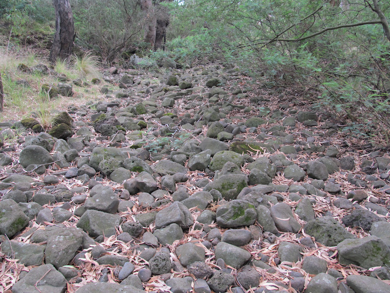
A river of rocks
On this occasion, the anabranch was not so much flowing with water as running with rocks. Unless the Barwon is running at least a little high, then the anabranch is dry. This reveals a stream of basalt rocks which look to have flowed down the watercourse over the centuries since those volcanic erruptions of the later Pliocene era (approximately 2 million years ago).
The anabranch at Fyansford April, 2012
Having seen some of the more recent flood events, it is not hard to imagine how these relatively small rocks would be tumbled down with all that rushing water until they came to rest in the anabranch. It also makes me wonder - could we see beneath the waters of the main waterway - what the riverbed would look like along its length. With any luck, we will never see the river run dry enough to find out.
This week, I returned to have another look. This time things were somewhat different:
The same part of the anabranch at Fyansford June, 2012
Recent rain over the past few weeks, including the "almost flood" of earlier this month, meant that the anabranch was well and truly flowing. Instead of a river of rocks, there was now a bubbling stream of water punctuated by several mini-waterfalls.
The anabranch flowing, June, 2012

The anabranch flowing, June, 2012


27 August, 2011

In the beginning...

It occurred to me recently that I knew very little about the geological origins of the Barwon River, so I set out to redress the issue, but found I was suddenly in some danger of having a great deal of information but very little in the way of understanding. I spent some time sifting through what I could find online and trying to put it in some kind of order. As I understand it, the geological evolution of the Barwon runs very roughly along the following lines:
Cretaceous rock formations at the West Barwon Dam
in the Otway Ranges
Several million years ago, the landscape surrounding the Barwon River looked rather different to what it does today. In fact, the formation of the Barwon dates back as far as the Cretaceous period (70-145 million years ago) when Australia separated from the super-continent Gondwanaland and dinosaurs still roamed Earth. During this period, sedimentary rocks were laid down which can still be seen to the south of the Barwon as rocky outcrops in some places. They also lie off the coast of western Victoria in the Otway Basin.
As recently as 40 million years ago, much of the land through which the Barwon now flows was covered by a wide sea. Early streams flowed from the higher ground of the Otways, northwards to the sea and limestone deposits formed along this ancient coastline.
Limestone outcrop forming the Belmont Escarpment
The Belmont Escarpment overlooking Barwon Valley and the Jerringot Wetlands is one such limestone outcrop, formed between 25 and 30 million years ago, which extends from a large deposit at Waurn Ponds towards Corio Bay.
More recently, during the Miocene period (7-23 million years ago) a series of plate movements and volcanic eruptions saw the coastline extending as far inland as the town of Meredith and the estuary of the Barwon located at Belmont Common. At this time, much of the present course of the Barwon lay under the sea with only a few nearby features such as the ancient granite of the the Dog Rocks at Batesford protruding above the water's surface to form small islands. It was this sea which deposited the limestone which can be found in the Batesford-Fyansford area and which was quarried for use by the Fyansford Cement Works throughout the 20th century. At around the same time, clay and other materials laid down combined with the Batesford Limestone to produce a band of sedimentary rock running down as far as the eastern fringes of Lake Connewarre. This is known as the Fyansford Formation.
Continuing plate movement throughout the Miocene period affected the various fault lines around the Geelong region such as the Bellarine Fault, causing the Bellarine region to lift and then around 20 million years ago, the sea to withdraw, uncovering the land and the current course of the Barwon.
Plioscene basalt rock formation beside the
walking track to Baum's Weir
Subsequent sea movements in the early Pliocene period (3.5-5 million years ago) resulted in the formation of a shallow bay between Torquay and Ocean Grove, covering the lower reaches of the Barwon once again and led to the deposition of shell beds which now lie under this part of the river including Lake Connewarre and surrounds. Sedimentary deposits across the region including the Bellarine Peninsula at this time produced what is called the Moorabool Viaduct Formation. In places it lies over the top of the Fyansford Formation.
It was also around this time that the movement of fault lines pushed the Cretaceous rocks of the Otway Ranges to their current height, giving the Barwon the strength to carve a path to the sea through new lava flows which occured in the later Pliocene era.
It was at this time that volcanic activity around Mount Duneed, Mount Moriac and Mount Pollock led to further changes in the river and the landscape. Until about 2 million years ago, the Barwon followed a course which saw it flow through a gap in the Barrabool Hills south of Lake Modewarre, then down a valley adjacent to the hills before reaching Fyansford. Around 2 million years ago, lava flows north of Inverleigh blocked this course, causing the inundation of the land to the west of Winchelsea before the river once again carved a new path to the sea. The lava flow followed the old riverbed, leaving a deep basalt deposit in this area and contributing to the wide basalt plains which extend across the region, providing extensive farming land today.
Newly-arrived European settlers were quick to see the material value of these basalt deposits, establishing bluestone quarries along the banks of the Barwon. It is this rock which can still be seen in the stonework of many historical homesteads and buildings across the region - the Barwon Paper Mill and its water race being a prominent example. Naturally, this quarrying made a lasting impact on the river surrounds. This is particularly noticeable along the walking track to Baum's Weir where the quarrying exposed the pliocene basalt, leaving high, rocky escarpments which tower over the river below, whilst a number of quarries were located along the river through Newtown which today have been converted to parkland.
Disused bluestone quarry at Baum's Weir showing
pliocene basalt deposits
At the same time, these lava flows extended out into the bay with three branches forming which dammed the lower Barwon in several places and created a number of lagoons - including a lake at Queen's Park, with another blockage below the Belmont Escarpment.
One of these flows produced the basalt ridge line which runs between Tait's Point and Fisherman's Point, separating Reedy Lake and Hospital Swamp from Lake Connewarre and Salt Swamp. As a result, Reedy Lake was fed by fresh water from the now-dammed Barwon whilst Lake Connewarre and the swamplands below the ridge were filled with seawater.
In time however, the barrier at Queen's Park along with that at the Escarpment eroded away, creating alluvial flats downstream. Likewise the lava flow at Tait's Point and another between Sheoak and Pelican Points which had obstructed the river flow were eroded away and water from the upper Barwon and Reedy Lake once more flowed into Lake Connewarre and the lower reaches of the river. This reconnected watercourse now ran alongside the third lava flow which extended to The Bluff and Ocean Grove, establishing the present course of the lower parts of the river and location of the river mouth.
Remains of basalt flow from the late Pliocene era
 forming Tait's Point (right)
It is believed that much of this erosion occurred during times of high flooding - such as 1995 - and as a result of seismic movement. The returning flow of water along with fluctuations in sea levels during the late Pleistocene period (c18,000 years ago) resulted in the build up of sand dunes along the southern basalt flow. In very recent times, with European settlement, this natural rate of sedimentation has been greatly increased by land-reclamation, farming, tree clearing and for a short but intense period, mining in the catchment region of the Moorabool River. All these factors have contributed to sedimentation, causing in-filling which has affected the depth of water in the lakes complex, turning Reedy Lake from an open water system to the swampy complex it has become.
In addition to the various geological and environmental events which shaped the course of the river, across millions of years, continuous erosion and subsequent sedimentation have also influenced the soil of the region, forming the land we see today.