Showing posts with label Shelford. Show all posts

20 April, 2016

Making tracks: decisions! Decisions!

Over the past six months and 21 blog posts, I've followed in the tracks of the gold diggers making their way from Geelong to Ballarat, looking at how they travelled, where they travelled, who they might have met along the way and what conditions they faced. The aim was to decide which - if any - of the various tracks was the "main" route to the goldfields - a claim made of each of these tracks at one time or another.
Google Earth image showing the likely routes via Shelford (red),
the Geelong-Buninyong Track (green) and Steiglitz (blue)
Teesdale it is claimed at a local park lay on the "main gold route". The Eclipse Inn north of Steiglitz was situated on the "best line of road" to the goldfields, boasted a real estate agent in 1853. A report by the Victorian Heritage Database states that "later the Warrenheip Road to Ballarat became the main gold fields route from Geelong", whilst in 1943 a local resident of the town of Meredith recounted that "when gold was first discovered at nearby Buninyong, Ballarat, Steiglitz and Bendigo, most of the traffic to those places started from Geelong and came through Meredith by bullock teams along bush tracks."
Even Skene St in the Geelong suburb of Newtown was claimed as part of "the main route to the Ballarat goldfields" - presumably a reflection of the flow of traffic west towards Fyansford and across the Moorabool River to the Geelong-Buninyong Track near the future site of Gheringhap.
The one thing which does seem clear is that each claim had its own angle: the best road, the main route, the most traffic, a particular point in time. What is clear however, is that over the years, huge amounts of traffic flowed along all routes to the goldfields of Ballarat. But were all the routes equivalent?
Store drays camped on road to Ballarat, TS Gill, 1855, Image held by the
National Library of Australia
Well, the distance of each was not the same. The journey from Geelong to Ballarat via the Geelong-Buninyong Track and the Plank Rd was around 50 miles (80km). From Geelong via Steiglitz and Warrenheip to Ballarat was about 59 miles (95km) whilst the track via the Leigh Rd to Shelford and then to Buninyong and along the Plank Rd was also around 59 miles. If travelling via Magpie Gully instead of the Plank Rd, then an extra mile or more could be added to the journey.
A difference of 9 miles or 15km is not so much on modern roads with fast cars, but to a digger walking the distance, this could amount to almost half a day's extra walking. If however, a dray were to become mired in Scott's Swamp, not only hours, but days could be lost, not to mention the potential for broken wheels and axles, the loss of an expensive horse or bullock or even the significant physical exertion required to unload and reload an entire dray full of supplies in order to lighten the load and escape the bog. As a result, whilst the shortest route may appeal to those on foot, road conditions may have been more important than distance to those travelling by vehicle.
To complicate the issue further, there were any number of alternate routes and tracks connecting each of the three roads running north-south. From the Steiglitz road it was possible to cross the Moorabool River and reach the Geelong-Buninyong Track via the Melbourne-Buninyong Rd intersecting at Green Tent, Sharp's Crossing which intersected at the same point, the Steiglitz-Meredith Rd and at least one other unnamed crossing to name a few.
From the west, it was possible to cross the Leigh River at 'Narmbool' and possibly also at an informal crossing near Bamganie. Today, a number of small fords cross the Leigh on private property, presumably it was no different in the 1850s. In a time when a bad track or tricky creek-crossing saw travellers take to the bush, forging their own path, it is not surprising that informal tracks and crossings proliferated.
Google Earth image showing the interconnecting tracks between Geelong and Ballarat. Red
lines show tracks marked on survey maps, blue lines show approximate routes described, yellow
lines show likely connections along and between routes using modern roads, green lines
show estimated routes based on surveyor's field books. Early inns along the routes are also shown.
Click to enlarge
Another important factor was date. When the gold rush first broke out in August, 1851 everyone wanted to be at Hiscock's Gully. Two weeks later, after the discovery of Golden Point, they were also flooding to Ballarat along the Geelong to Buninyong Track. The surface alluvial deposits however, were quickly worked out and within a short time, deep lead mining became common. As the miners followed these leads, mining activities spread out across the Sebastopol Plateau following the course of an ancient river underlying the Leigh. It makes sense that anyone travelling to these mines during the 1860s would consider travelling via Shelford.
At Steiglitz, the discovery of quartz reefs in 1855,  drew traffic from Geelong and also from Ballarat, presumably making the route from Geelong to Ballarat via Steiglitz and Warrenheip more appealing at that time. This road also provided access to other nearby goldfields such as Mt Egerton, Dolly's Creek and Gordon to name a handful.
Despite all of this however, it is worth remembering that coaches - including Cobb & Co.'s famous Leviathan Coach capable of carrying 89 passengers - continued to run directly between Geelong and Ballarat along what soon became the Geelong-Buninyong Rd. After the discoveries at Steiglitz, extra services ran via Hope's Bridge over Sutherland's Creek to the town, however coaches from Steiglitz for Ballarat still travelled via Meredith, Buninyong and Magpie Gully, rather than the Eclipse Inn and Warrenheip. A comparison of distance shows the coach route to be only a mile or so shorter than travelling via Warrenheip. I cannot see any mention of a coach service via Mt Mercer throughout the gold rush period, however the Portland Bay service from Geelong did pass through Shelford, Cressy and Fiery Creek further to the west.
Cobb & Co.'s Leviathan Coach, c1862. Image held by the Victorian State Library
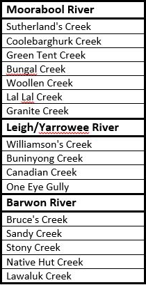
Regardless of which route the diggers chose, one thing was certain: at some point they would have to cross, walk alongside or take water from the the tributaries of the Barwon River. Whichever route they chose would require not just one, but numerous creek and river crossings. Whether at Batesford, Fyansford or east of Buninyong, the Moorabool River had to be crossed. Travelling via Shelford also meant crossing the Leigh/Yarrowee River at least twice, if not three times, not to mention the many creeks and gullies along the way. Below is a list of the main creeks along the three routes, grouped according to the river into which they flow.
In the early days before bridges were built, fording creeks and rivers was inevitable and bad weather could have a significant impact, not only on the road surface, but also on the ease with which a creek or river could be crossed - if it could be crossed at all. Newspaper reports of flooding often also came with reports of drownings, both of animals and humans as attempts were made to cross dangerously swollen creeks and rivers. Another reason for diggers to consider carefully which route to take.
There is one other factor which could also influence the decision and which could significantly alter the flow of traffic along a particular road: maps.
And some of those maps will be the topic of my next post.

14 March, 2016

Making tracks: via Mt Mercer

I initially began researching the route travelled by the diggers who flocked to the goldfields of Buninyong, Ballarat and beyond after noticing that a number of towns located on the rivers, creeks and gullies of the Barwon catchment claimed to be on the "main gold route" or on the "best line of road" to the goldfields. But how could places as far apart as Teesdale on the Leigh Road and the Eclipse Hotel at Durdidwarrah and Morrisons, along with all the towns which sprang up along the Geelong to Buninyong Track, justify their claims?
It quickly became apparent that there were several different routes which hopeful prospectors could take to the diggings and each had its own claim to being "the main route from Geelong to Ballarat" (or Buninyong for the current purpose as all roads from Geelong passed through or near that town). The shortest route was certainly the bullock track which lead from Geelong to Buninyong. It was well established by the 1840s and had been used by the mail coaches to travel between Geelong and Buninyong since 1846. If volume of newspaper content is anything to go by, this was certainly the busiest route to the goldfields and the topic of my most recent posts.
Teesdale of course, is not on this route. It was however on the road taken by another of the earliest mail coaches in the district - the Portland Bay Mail Coach. The mail from Geelong (and from Melbourne via the steamer) was carried by coach through Leigh Road (Bannockburn), Teesdale, The Leigh (Shelford), Rokewood and onwards to join the Melbourne to Portland Bay mail at Fiery Creek (Streatham/Beaufort). An 1856 survey map of the Teesdale area describes this road as the "main road from Fiery Creek to Geelong via Batesford".
Shelford iron bridge under construction 1873-4. The timber pylons of the original
bridge are visible between those of the new bridge
Like the Geelong to Buninyong Track, the Portland Bay Road required travellers to undertake several river and creek crossings - the Moorabool River at Batesford, Bruce's Creek at Leigh Road and two crossings of the Leigh/Yarrowee River. The first of these was at The Leigh where, prior to 1850, the crossing was made via a ford. After this date, a wooden bridge was installed which served until 1873-4 when a wrought-iron box girder bridge was erected as per the design of Leigh Shire engineer C.A.C. Wilson.
After crossing the Leigh, those travelling to Buninyong needed to branch off the Portland Bay road and head north. First however, they could take a meal or stay overnight at the Settlers' Arms Inn, before following the track which lead to Mt Mercer and on to Buninyong. The inn was built in 1843 by Captain Francis Ormond who leased the surrounding land from George Russell of the Clyde Company, agreeing to improve the area and build the inn which soon prospered as a result of the passing trade.
Settler's Arms Inn built by Captain Francis Ormond in`1843. Situated near
the Shelford bridge across the Leigh River, the inn was a staging post on the
Portland Bay mail route. It was demolished in 1983 to allow construction
of the current road bridge. Image taken in 1975 is from the John T Collins
Collection, State Library of Victoria
Whilst none of the early maps such as those produced by surveyor AJ Skene (1845), Ham's map of the routes to the Mt Alexander & Ballarat diggings (1852) or Sands & Kenny's Map of Victoria (1859) show a road running from Shelford to Buninyong, the track did exist and it was used to access the goldfields. Survey maps as early as 1851, show the beginning of a road leading south from Buninyong "to The Leigh". It was not until 1857 however, that it was officially surveyed - at least in part - by government surveyor Maurice Weston and was indeed titled "part of Geelong and Ballarat Road from Shelford to Mt Mercer".
A dirt track leading into Shelford, taken during the late 19th century. Image held
by the State Library of Victoria
An important point of distinction however, which may also explain Teesdale's claim to be on the "main gold route" from Geelong to Ballarat, is a description which appears in the newspapers from the 1850s onwards, referring to the "main road from Geelong to Ballarat via Mt Mercer". It is probably telling that the description of this road always seemed to come with the qualifier "via Mt Mercer". I suspect this meant not that this was "the" main road, but rather that it was "a" main road and that it ran via Mt Mercer. In this era the phrase "government road" or "main government road" was often also used. It described official roads built and maintained by the government. From the 1860s, local road districts were established to levy rates and to maintain roads across the colony. The colonial government however, still retained responsibility for the most important roads, therefore a "main road" was any road which was paid for and maintained by the government rather than by the local road district or shire council. Having a road declared as a "main road" by the government could remove significant financial strain from a struggling rural shire.
Another consideration is the term "main gold route". Does this mean the route taken by the diggers to get to the goldfields or the route taken by the gold escorts bringing the gold back to Geelong? Newspaper reports show that the the contractors carrying gold to Geelong travelled via the Geelong to Buninyong Road. It was for this reason that a police paddock and associated buildings were established at Meredith in 1853 (and a little later also at Burnt Bridge), to provide a base for the police officers accompanying the gold; a staging post for changing horses.
This early photograph taken c1852-1854 shows the Ballarat gold escort. Image
held by the State Library of Victoria
Whilst it may have been shorter and there may have been more traffic on the Geelong to Buninyong Track, it was not without its problems. When the weather was bad, some sections of the road became a quagmire. Negotiating "Scott's Swamp" could prove an almost impossible prospect. The approach from Melbourne could also be a difficult journey; one traveller reported seeing hundreds of drays stranded in the mud during a single trip to the goldfields of Ballarat. It is probably no surprise then, that whilst researching a previous post, I found mention of the track from Shelford to Buninyong being used by travellers when the Geelong to Buninyong Track was impassable during bad weather.
It may have been longer, however travellers would go a significant distance out of their way to avoid bad roads, even taking to the bush when necessary.
It is also worth noting that the Geelong to Buninyong Road and the road via Mt Mercer did not exist in isolation from one another. They were connected by tracks (and later roads) which ran east-west between them. As I mentioned in an earlier post about the Green Tent, there was a track running from that place back to Shelford which was used by bullockies and those wanting to graze their stock, as well as the track which became the Meredith-Shelford Rd. If conditions were proving too difficult on one road, it was possible to veer off and head for the other.
And it is at this point that another local tale surfaces. Whilst on a visit to 'Narmbool' (the squatting property established in 1839 by Hugh Niven, now owned by Sovereign Hill), I was told that an old track leading down across Williamson's Creek was "used by the diggers during the gold rush". This would seem to be confirmed by a road marked on an 1892 geological survey map, running in a direct line between Horsehill Rd and Williamson's Creek along the fence line we were shown. After crossing the creek, survey maps of Clarendon Parish from 1915 show the road - presumably following the earlier track - continuing on to a fork. One branch ran north, following what today is a vague track which becomes Pryor's Rd, the other travelled only a short distance south west to Sand Rd. Both Sand and Pryor's Roads meet up again to the east of the mining town of Garibaldi before joining the Buninyong-Mt Mercer Rd. Thus the diggers could follow this road north to Buninyong or they could again join the Geelong to Buninyong Rd to the east of Scotsburn, or possibly further west, thus avoiding Scott's Swamp.
Local sources say that, a track used by diggers heading to the goldfields
(presumably from' the Geelong to Buninyong Rd) ran down the hill at the fence
line to cross Williamson's Creek at this point 
It is also worth remembering however that as the gold rush progressed, diggings spread out across the countryside. With the advent of large companies and deep lead mining towards the end of the 1850s, mines were established along the banks of the Yarrowee/Leigh River as far south as the Leigh Grand Junction Bridge and a little beyond. It makes sense therefore that by the time they were surveyed in 1857, that the Shelford-Mt Mercer Road and the subsequent Mt Mercer-Buninyong Rd would be the main access route for those heading from Geelong to the mining settlements along the river such as Garibaldi and Scotchman's Lead.
Looking at the survey maps available from the 1850s for the parish of Enfield, the old track by and large, followed the same course as the modern road, although where the modern road veers to the west to meet the road from Dereel, the old track stayed close to the river past Mt Mercer. Further north near Garibaldi, the track again followed a slightly different course, crossing the Yarrowee River about 700m north west of the present crossing which was not built until 1866. As I described in an earlier post, the river crossing at Garibaldi was dangerous, with three people said to have lost their lives during flooding prior to the erection of the bridge downstream.
Google Earth image showing: modern roads (yellow), Buninyong-Mt Mercer
Track (green), unused road on 'Narmbool' (blue), other pre-survey tracks (red).
Click to enlarge
Unfortunately the only 1850s survey map which I am currently able to access is that for Enfield Parish, so I am uncertain of the exact path of the original track to the north or south of this area. It does appear however, that the entry to Buninyong was intended to be via a more direct line one block to the east of the current alignment, which makes me wonder if perhaps Sandys Hill Rd (which intersects the road to The Leigh as marked on the survey map), may have been part of the original track from Mt Mercer.
It is also worth remembering that there may well have been other informal crossing points along the Leigh/Yarrowee which also gave access for those heading to the goldfields. I know of at least one bridge which no longer exists, but which was used by workers crossing to 'Golfhill'. Located at the end of Henderson's Rd, Bamganie, it was a timber swing bridge which existed into the 20th century, however I am unsure of its age. Similarly, there is a small bridge on Kelly's Rd, Grenville where the Leigh can be crossed, however the road itself does not appear on the earliest survey maps.
No doubt there were other crossing points and tracks along the way, all of which could have been used by those travelling to and from the goldfields to reach the road between Buninyong and Shelford.
If at any point I find more detail I will update this post accordingly.


07 August, 2015

Like Father...

Charles Anthony Corbett (CAC) Wilson (1827-1923) was an English migrant and chartered engineer whose father was a London solicitor. He migrated from London to Australia in 1851 and joined the gold rush at Golden Point near Ballarat, but soon found that this was not a particularly productive pursuit and headed to Geelong where he found work surveying the Geelong-Melbourne railway line.
Between 1854 and 1860 he worked as an assistant engineer with the Central Roads Board, surveying the Geelong-Ballarat Road and contributing to a number of bridge designs in the region, including the iron Barwon Bridge which opened in 1859.
Barwon Bridge c1861, Image held by the State Library of Victoria
In 1857 he married Maria Connor Powell. The couple and their large family of 15 children lived in Teesdale. In 1863 CAC Wilson took up the positions of engineer and secretary for the Shelford District Road Board which the following year became the Leigh Shire.
One of his early projects for the shire would have included a bridge over the Warrambine Creek (a tributary of the Barwon River) on the Lower Western Road (Hamilton Highway) at Laing's Hotel past Inverleigh. The bridge was to be 30ft in length and have three spans. It was to take the place of an earlier ford and perhaps was seen as an urgent improvement after an accident only a few months before in October, 1863 when a mail coach attempted to cross the flooded Warrambine Creek was washed away, losing the luggage and most of the mail it was carrying and presumably the horses which could not be cut from their traces in time. The driver and a passenger however, made it to safety.
Another early design produced by Wilson was the plan for the construction of a new bridge over the Native Hut Creek at his home town of Teesdale. From the 1860s, Wilson had been making periodic reports requesting various repair measures for the bridge until in 1877 he finally indicated to the council that it was in need of replacement.
Accordingly, he drew up the plans and in February 1879 the contract was put out to tender. The bridge was to include a single masonry pier with masonry abutments on each bank, supporting a timber deck topped by road metal. Little more than a month later, work was under way.
Engineer's drawings of the Teesdale Bridge by CAC Wilson, Image held by the
State Library of Victoria
By the turn of the century however, the decking timbers in the new bridge were deteriorating and in 1901 Wilson, as shire engineer, was calling for funds to have the timber supports replaced by steel girders. I suspect these measures were implemented as the bridge today fits this description.

The Teesdale Bridge in 2013
Wilson was not only an accomplished engineer, but also a revolutionary one. Many of his bridge designs were influenced by his relationship with the Department of Engineering at Melbourne University who at that time were conducting research into the construction and design of wrought-iron bridges. This relationship is reflected in bridges such as the Barwon Bridge mentioned earlier and the wrought-iron girder bridge over the Leigh River at Shelford, built between 1873 and 1874 which I showed in a previous post.
Shelford Bridge designed by CAC Wilson
Not surprisingly, another of Wilson's projects was to design the new shire hall which was opened in 1872 on the Rokewook-Shelford Road - a relatively isolated location, yet one which was central to the major towns of the shire.
Leigh Shire Hall, built 1872
Closer to home again, Wilson was also the engineer responsible for the construction of the Black Gully dam, built between the towns of Inverleigh and Teesdale in 1874 as a potential water supply for both towns. Today, this site can be found near the north east boundary of the Inverleigh Flora and Fauna Reserve where the remains of the dam can still be seen.
A rainy day at Black Gully Dam. This photo was taken from atop the remains
of the earthen wall commissioned by Wilson. Note the stones at bottom
right of the picture
Plans to use this water supply however were short-lived. In 1880 when severe flooding damaged the dam wall, the cost of repair was deemed prohibitive and it was decided to find another water supply. Fortuitously, a couple of years earlier in 1878, a second site closer to Teesdale had been gazetted following some testing by Wilson in the form of sinking wells. This lagoon, which provided Teesdale's water until 1974, became known as Chinaman's Lagoon.
A few kilometres further north, at the border of the Leigh and Meredith Shires was another small bridge which also came in for attention from CAC Wilson during his tenure as shire engineer. This was Taylor's Bridge at Bamganie, so called because it abutted the 1880 land selection of Mr Edwin Taylor. The bridge on Henderson's Road crosses Wilson's Creek just south of its confluence with Woodbourne Creek. Today it is a simple, concrete structure with a graveled surface, barely noticeable as you navigate the twists and turns of the road at this point.
Taylor's Bridge, Bamganie 2013
In February, 1883 however, it was a timber structure which was unable to stand up to the heavy floods which swept down the creeks to the Leigh River below. The bridge was destroyed and assessment by Wilson and his counterpart from the Meredith Shire determined that a replacement was needed. Contracts were called by Leigh Shire and the following year - after some delays - the bridge was rebuilt in similar form to the original and with a timber and stone culvert reinforcing the road near the western end of the bridge. This bridge served the shires for more than twenty years until in 1905 it was declared dangerous and the Meredith Shire resolved to have Wilson effect the necessary repairs. It was not until August the following year however, that Wilson declared the bridge closed for this purpose.
In the late 1880s Wilson designed McMillan's Bridge, a replacement for an earlier timber truss bridge over the Mt Misery Creek (at the time called the Little Woady Yalloak River) on the Rokewood-Skipton Road which had served since 1856. The new bridge was an iron and masonry structure like a number of those described above, employing a pair of 99ft lattice girders in a single span, but reusing the sandstone abutments from the previous structure. The deck was of hardwood topped with road metal. The bridge still stands today on the Rokewood-Skipton Road which at that time, bore the name of the Upper Western Road and ran from the Ballarat-Geelong Road through the towns of Leigh Road (Bannockburn), Teesdale, Shelford and Rokewood, crossing the Leigh Shire to the north of The Lower Western Road which also traversed the shire. Both roads were in large part the responsibility of the Leigh Shire and engineer Wilson.
In addition to these better-known structures, Wilson was also responsible for the maintenance and reconstruction of any number of smaller, lesser-known bridges and crossings such as the stone causeway which crossed the Cressy-Shelford Road in the 19th century, and a tiny bridge in Teesdale which crossed Native Hut Creek on Tolson Street. Wall's Bridge still stands there today and is clearly not new. A review of historical newspapers indicates that a timber bridge existed on the site at least as early as the 1870s, however like all such structures it needed regular maintenance and repair. By 1908 it was in need of replacement. Council voted that is should be replaced with an iron girder structure and in March the following year, tenders were called. In a matter of weeks however, it was decided that none of the tenders were acceptable and Wilson and another councilor were to discuss cheaper alternatives instead. All was quiet on the matter until August, 1910 when Wilson provided the council with three estimates for bridges constructed from timber, stone and iron, or concrete.
Finally, in March 1911, the council decided upon a timber and concrete bridge and the contract was awarded to John Pryor who had started work by July. Looking at the bridge today, it consists of two timber piers topped by iron girders, overlaid with timber and a - very - thin coating of bitumen. At each end is a small concrete abutment.
Bitumen and timber decking on Wall's Bridge, Teesdale
I am no expert, but would guess that the piers and abutments date back to the final years of CAC Wilson's tenure as shire engineer. Whilst the timber decking also looks to be of some age, I can only assume that if the bridge was built to the original specifications, then the iron girders must have been added as part of more recent repairs, with the timber either reused or replaced as necessary.
Wall's Bridge, Teesdale
And so it went on, year after year, decade after decade, bridges, roads, dams, buildings; CAC Wilson designed them all. In total, he was responsible for the construction of at least 108 bridges throughout the district, built first in timber then in metal and concrete as he strove to find practical application for the theory developed by Melbourne University and provide cheaper, more durable alternatives for shire infrastructure.
He finally retired as the engineer of the Leigh Shire in 1910 when he was replaced in this role by his eldest son Charles Corbett Powell Wilson. His tenure as shire secretary however, continued for several more years, ending with his retirement in 1917 - a total of 54 years service to the shire.
Wilson died in Geelong on 7th October, 1923, survived by ten of his children and is buried in the Portarlington Cemetery.

23 February, 2014

Ducking down to Shelford

After months of preparation and weeks of promotion, the big day had finally arrived. The 2014 Shelford Duck Race was upon us! And naturally enough we headed off for a look.
Stalls and activities at the 2014 Shelford Duck Race
This was not the first time we had intended to check out the fun of this particular fair, but last year's attempt was derailed by a significantly longer paddle down the Barwon than expected. This year however, I was determined that we would not miss it, so we arrived in good time and browsed the food and produce stalls. The kids availed themselves of some of the rides and we sipped drinks in the shade as we waited for the race to start.
Camel Rides!
As we approached the designated start time of 3:30pm the crowds began to build along the banks of the "Mighty Leigh" as it was referred to on several occasions. I slipped into position near the start line so as to get a good view of the action and sat down to wait and wait...
The calm before the storm, the Leigh River
As the designated start time came and went, officials scurried back and forth (an issue with the range of the microphone it seemed):

A race official
Marshals herded the ducks towards the start line and waited for the signal to begin:

At the start line in the hands of the officials
Finally, as the clock ticked past 3:50pm we had a start.
Off and racing!
Progress was slow, but some nearby opined that it was about twice the speed of last year's race. With commentary beginning to crackle through the speakers, the ducks bobbed slowly along in the current.
The marshals followed behind, poking at stragglers with their sticks and making sure that all 750 participants in the sold out race remained on course and didn't get stuck wallowing in the shallows.
After the excitement of the start of the race, I moved downstream to a position midway along the course and waited for the ducks to round the bend.
Midrace
Ever so slowly, the ducks made their way towards us. By the time they reached the turn, the field had become quite strung out, however as the finish line drew nearer, the competitors came back together again, ready for a tight finish.
A bunch finish
 Then, after about 30 minutes and around 100 metres, the finish line was in sight. As the first duck crossed the line a cheer went up and it was quickly grabbed by an eager official who announced the winning number...

And the winner is...
...256!
It was closely followed by duck number 185 with duck 201 taking out third place. Amidst some excited chatter, the prize-winners came forward, the crowd dispersed to continue the festivities and the ducks were bundled up and taken off to begin training for next year's race.

29 September, 2013

Squattocracy - life on the run!

The first Europeans to settle on the plains surrounding the Barwon River and its tributaries were squatters and many of their names would still be familiar to us today: names such as Armytage, Roadknight, Russell, Swanston, Austin, Learmonth, Fisher, Bell, Mercer and Morrison to name a few.
And they are with us still! Street signs from the
suburbs of Geelong, Geelong West, Manifold
Heights, Belmont  Newtown and Corio.
They can be found in the names of our streets, parks and suburbs and towns. In addition to the above street names (and a few besides such as Highett Road, Highton and Clyde Road Bannockburn, McLeod and Read Streets, Meredith), the suburbs of Manifold Heights, Newcomb, Thomson, Highton, and the towns of Drysdale, Batesford, Bells Beach, Bellbrae, Stieglitz, Pollocksford and Sutherlands Creek are all named for original squatters in the district as are Point Roadknight near Anglesea, Cowies Creek, Austin Park, Stead Park and then of course, Fyansford - named for Captain Foster Fyans who arrived in the district as police magistrate at the request of these squatters and himself tried his hand as a squatter in the coming years.
These first settlers arrived in the region in 1836 following John Batman, keen to find pasturage for their stock. With this in mind, various groups set out to investigate the area - in particular the explorer and surveyor John Helder Wedge and the ill-fated Hesse and Gellibrand. From early 1836, stock was landed at Williamstown, Point Henry and Indented Head and left in the care of shepherds, whilst the squatters made their own explorative journeys in search of suitable runs. At the same time, some travelled overland with their flocks from New South Wales.
Amongst the very earliest settlers were representatives of the Derwent Company. Formed from the remains of John Batman's Port Phillip Association they were a group of Tasmanian settlers who had set out in 1835 to acquire land in the Port Phillip district from the indigenous occupants. Despite the government in New South Wales declaring Batman's transaction with the Wurundjeri people invalid, they came anyway.
By the late 1830s the Derwent Co. held 26,000 acres of land extending across the "Portland Bay" region including the Barwon, Moorabool and Leigh Rivers. Its members included Captain Charles Swanston, Major William Drumond Mercer and his son George Duncan Mercer, Thomas Learmonth, George Armytage and David Fisher.
"Barwon Falls" 1848 as painted by Charles Norton, artist, civil servant and
squatter on the Barwon River. Image held by the State Library of Victoria
Another group of investors formed the Clyde Co. which was established in 1838 by seven Scottish investors. They selected land along the Leigh and Moorabool Rivers, which was managed first by Philip Russell and then by his half brother George who eventually settled at Golf Hill near The Leigh (later Shelford).
George Russell, 1852. Pioneer, settler and manager of the Clyde
Company. Image held by the Victorian State Library
In addition to the big companies, individual families such as the Austins of Barwon Park, established large holdings on the Barwon whilst properties such as Moranghurk and Borhoneyghurk on the Moorabool and Narmbool on the Leigh were established by individuals or partnerships.
By 1842 however, the Derwent Co. was being wound up, with various founding members purchasing leases in their own right. The Clyde Co. survived until 1857/1858 at which time George Russell bought the freehold of Golf Hill, an area of 8,500 acres which he eventually expanded to 28,000 acres.
Today, through the foresight of Victoria's first Lieutenant-Governor, Charles Joseph La Trobe, a record remains which details many of these early settlers and their holdings. During his governorship on 29th July, 1853, La Trobe wrote to Victoria's pioneering settlers asking them if they could in turn reply to him, describing what they remembered of the dates and places in which they and their contemporaries had settled in the 1830s. His request generated some 58 replies from across the newly-declared colony - several of them dealing with settlement along the Barwon, Moorabool and Leigh Rivers - they were eventually compiled by Thomas Francis Bride and published in 1898 titled: Letters from Victorian pioneers: being a series of papers on the early occupation of the colony, the aborigines etc.
Lieutenant-Governor Charles La Trobe. Photo held by
Ballarat Heritage Services

From this and other sources, including the various newspapers of the day and government gazettes it is possible to build a fairly good picture of who these pioneering settlers were and where they held their various squatting runs.
The following table - whilst no doubt incomplete - shows who many of the initial landholders were and when they took up their runs. In each case I have attempted to identify the original occupant, however in some cases there may have been an earlier squatter on the land whom I can't identify through online records. If I find further information I will update accordingly.
As time has progressed, it has seemed appropriate to add some early properties to the list below which were not original squatting runs, but were rather the next generation of estates, established once land was opened up for sale. Examples include the Hope brothers at 'Darriwill' and 'Lynnburn' as well as Dr John Learmonth at 'Lawrence Park' all on the lower reaches of the Moorabool River.

Barwon River
Caroline Newcombe and Anne Drysdale
1841
Geelong
Derwent Co. (David Fisher)
1837
Kardinia
Dr Alexander Thomson
1837
Highton
John Highett
1837
Barrabool Hills
John Charles Darke
c1837
Roadknights
1836
Pollocksford
Captain Pollock
1836
Murgheboluc Flat
Yuilles
1836
Weatherboard
Derwent Co (David Fisher)
1837
(Toolun, St Leonards & Waterloo Plains)
Thomas Austin and Brothers
1837
Henry Hopkins
1837
Derwent Co (Thomas Armytage)
1836
Yan Yan Gurt*
Roadknights
1838
Deans Marsh*
Roadknights
1848
Wesleyan Church
(Rev Francis Tuckfield)
Buntingdale Mission Station
August 1839
Paraparap
Frederick Dewing
1838
Gerangemete
Roadknights
1839
Ricketts
Thomas Rickett
<September 1837
River Station
Roadknights
1840
William Harding (with John Highett)
1837
Murdeduke (originally part of Mt Hesse)
John Highett (with William Harding)
1837
St Stephen
John Stephens
<1841
Long Water Hole/Barrunah Plains*
Derwent Co. (James Austin)
1837
Warrambine*
Derwent Co. (Prentice)
<1842
Moorabool River
John Anthony Cowie & David Stead
March 1836
George & Robert Hope
1846
Batesford
Alfred & John Bates
1837
Manifold’s Ford (aka Dog Rocks/Batesford)
Thomas & Peter Manifold
1836
Thomas and John Learmonth
1839
Sutherland’s Creek*
Joseph Sutherland
1836
George, James & Robert Hope
1846
Russell's Bridge
Clyde Co. (George Russell)
1836
William Taylor & Dugald McPherson
1840
Robert von Stieglitz
March/April 1838
John Norman McLeod
1837
Blakeney & George Airey
1840
John Norman McLeod
October 1837
John Wallace
1838
Bungal
George Egerton
1838?
John Anthony Cowie & David Stead
1838
David Stead
1838
Hunterston
William Patterson?
1840s
Peerewerrh
Fairbairn & Gardner
<1849
Borambeta
Charles & Joseph Bradshaw?
<1849
Bolwarra
James Clarke?
1837?
Ballan
Robert William Stieglitz
1838
Leigh/Yarrowee River
Weatherboard
Derwent Co. (Thomas & Somerville Learmonth)
April 1837
(Native Creek No. 1)*
Derwent Co. (Thomas & Somerville Learmonth)
April 1837
(Native Creek No. 2) (later Woolbrook)*
Derwent Co. (Thomas & Somerville Learmonth)
1837
(including Upper Leigh & Tall Tree Creek Stations)
Clyde Co (George Russell)
1839
(later Barwonleigh)
Derwent Co. (Thomas & Somerville Learmonth)
April 1837
Alexander, Charles & John Wilson
1844
Cargerie
George Frederick Read Jnr
January 1838
Mount Mercer
Derwent Co. (David Fisher)
March 1838
Mount Mercer Cattle Station
Derwent Co. (Major William Drummond Mercer)
1838?
Hugh Niven
January 1839
Warraneep
Levitt brothers and one other
1840
Waverley Park (later Bonshaw)
Henry Anderson
1838
Thomas & Sommerville Learmonth
1838
Archibald B & WC Yuille
February 1838
*These properties whilst not lying directly on any of the three rivers, were an integral part of the district and each did have at least one creek which flowed to either the Barwon or the Moorabool.
It is worth remembering also that runs often changed hands repeatedly (sometimes within a matter of months) and areas of land could be transferred in part or wholly between settlers meaning that the boundaries of properties shifted over time as squatters expanded or consolidated their holdings, forming and dissolving partnerships on a regular basis.
During the 1850s and 60s, following the dispersal of the Clyde and Derwent Companies, leases changed hands and the pre-emptive rights to various properties were purchased. The era of the squatter had well and truly reached the three rivers.