 |
| A glimpse of the Moorabool Valley through the garden at Moranghurk |
 |
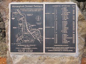
| Plaque detailing the soldier settlers of Moranghurk |
In Victoria, the scheme was administered by the Closer Settlement Board under the direct control of the relevant minister. For various reasons, including difficult economic circumstances, high land prices, inadequate land allocations and in some cases the selection of inappropriate settlers, the scheme was less than successful. There were complaints of government interference and the Commonwealth who funded the scheme lost money as did the various state governments and the settlers themselves. In Victoria, 17% of soldier settlers were forced off their properties by 1929 and royal commissions ensued in most states.
 |
| Many books such as this were published to provide advice to would be settlers. Image taken from the Victorian State Government website |
During the Second World War, the need for soldier settlement was once again on the cards and determined not to repeat the mistakes of the past, the Rural Reconstruction Commission was set the task of investigating the causes of previous failures and ensuring that they did not happen again. In this, they were largely successful and the second wave of soldier settlement saw a careful selection of applicants who were allocated viable blocks of land on reasonable terms in an improving economic climate. Not surprisingly perhaps, this second attempt was significantly more successful than the earlier scheme and between 1946 and 1959 the Commission purchased 1,206,660 acres of land for a total of £19,963,282.
 |
| Looking south from the Bannockburn-Shelford Road, once the Woolbrook Estate/Native Creek No 2 Estate? across fields of canola |
To create these opportunities however, a significant amount of land had to be made available for purchase. Where possible, crown land was used, but this was not always enough so the government undertook measures to resume thousands of acres of land from the large estates.
 |
| Larundel Estate Soldier settlement plaque at Elaine |
Property
|
Owner
|
Acres
|
Year(s) sold
|
Number of farms
|
Janet Biddlecombe
|
13,501
|
1953, 1956
|
18
|
|
Tall Tree
|
Janet Biddlecombe
|
9,546
|
1947, 1951
|
9
|
Larundel
|
Austin family
|
7,070
|
1952
|
12
|
Moranghurk
|
John L Matheson
|
17,000
|
1953, 1954, 1955
|
26
|
Shelford
|
32,500
|
1955
|
51
|
|
| Mt Gow |
Estate MN Lees
|
12,000
|
||
Ingleby
|
Armytage family
|
1951
|
||
Barunah Plains
|
Estate of James Russell
|
20,000
|
1951, 1958
|
23
|
Whilst soldier settlement was avidly taken up by the newcomers, the compulsory acquisition of lands which had in many cases been held by families for generations was not always well received. Janet Biddlecombe of Golf Hill felt that her property could be of greatest use to the community if it were maintained intact and was no doubt used to support her many charitable enterprises, however by the time of her death in 1954, the property was already in the process of being divided and sold.
 |
| Plaque detailing the soldier settlement of the Shelford and Golf Hill Estates |
Barunah Plains (aka Warruk-Barunah Plains and also known as Long Water Holes), on Warrambine Creek which flows into the Barwon to the West of Inverleigh was divided in two; half used for soldier settlement and half remaining with the Russell family who had held the land since the 1850s.
 |
| Wingeel soldier settlers (Barunah Plains South) memorial |
No comments:
Post a Comment