Pages

28 April, 2012

The shepherd's companion

In the latter part of 2011 I made a few forays up the Barwon to the somewhat grandiosely named Mt. Brandon Peninsula. The results of my travels appeared in some of my previous blog posts. In particular, I spent some time photographing a nest belonging to a pair of Willie Wagtails.
Willie Wagtail and its nest, November, 2011
Yesterday, I headed back to Baum's Weir and the peninsula to see what was new. Everything was much as it had been before with the exception of a few dropped branches and a couple of non-native trees which were well into the swing of autumn. I did see several European Goldfinches past Baum's Weir and up on top of the peninsula as well as a flock of Flame Robins. This was the first time I'd seen either on the river.
I also went back to investigate the nest belonging to the Willie Wagtails. What a difference a few months can make. When I last visited the nest in November, the Willie Wagtail breeding season was well under way. It generally lasts from August to February and can involve the rearing of several broods of chicks.
Willie Wagtail in its nest, November, 2011
At that time, the female was always in the nest when I arrived and as I mentioned previously, she and her mate were typically aggressive in defending their territory both against myself and on one occasion, against an unfortunate Crested Shrike-tit which happened to venture onto their branch. I have also seen a Willie Wagtail take on a kingfisher and I believe they are quite happy to argue the point with even larger birds, including kookaburras and Wedge-tailed Eagles.
Perhaps because of their gregarious behaviour and chattering calls, the folklore of indigenous cultures across Australia tends to describe Willie Wagtails as the bearers of bad news. They are recognised as intelligent but are thought to tell-tales and steal the secrets of humans, according to some tribes, informing the recently departed if their living relatives speak ill of them. I have not been able to discover whether the local Wathaurong tribes have cultural links to the Willie Wagtail, however they cannot have been unaware of these vociferous little creatures in their landscape. They may even have raided their nests for eggs as they are often located well within human reach.
As is clear from the above photos, the nest is a cup shape composed of grass, bark and other fibrous bits and pieces, all bound together with cobwebs. The inside of the nest is lined with hair, fur and soft grasses. No-one seems keen to tell me what the spiders think of having their webs commandeered by the Willie Wagtails, but then, it is also quite possible that the spiders themselves have become dinner and are in no position to complain.
This time when I arrived, there was no sign of the birds and the nest was clearly in a state of disuse, except - somewhat ironically perhaps - by a spider or two who seemed to be taking their revenge.
Willie Wagtail nest April, 2012
Looking at the nest in November and now, it seems there were some additions made prior to the departure of the birds and the arrival of the spiders. The large twig still with seed pods attached is a more recent addition, as is what appears to be a piece of fishing line. Hair is also evident. It would be interesting to know where the birds sourced their building materials as there are not a lot of houses and their domestic animals in the immediate vicinity nor are there herd animals to provide these fibres.
It is from their habit of closely shadowing sheep and cattle or even riding on their backs - presumably to catch the insects they stir up in their wake - that Willie Wagtails are known as the Shepherd's Companion. Presumably they also take the opportunity to pinch a hair or two at the same time.
 I also noticed another interesting detail during yesterday's walk.  In November, I saw a Brush Cuckoo in the same tree as the nest and also saw Fan-tailed Cuckoos nearby. Now that the Willie Wagtails are no longer breeding, I neither saw nor heard any sign of cuckoos.
Brush Cuckoo in the vicinity of the Willie Wagtail's nest November, 2011
This is probably no coincidence as I discover that various species of cuckoo, including these two, will attempt to place their eggs in the Willie Wagtail's nest. The wagtails however, often recognise the impostor and remove it from the nest.
When summer and the nesting season end, the cuckoos - presumably realising the gig is up - depart for more northerly climes. The Willie Wagtails by contrast, hang around until it is time to start the whole process again.
As Willie Wagtails generally pair for life and are known to reuse nests, or to recycle old materials in building a new one, I will be keeping an eye out to see which - if either - happens with this nest and the birds who built it.


25 April, 2012

slitherin'

Just when you thought it was safe...
Last week, before the weather turned into its current unpleasant approximation of winter, we were enjoying some very mild late Autumn sun. As mentioned previously, I took the opportunity to go for a ride to see if I could chase down some of those elusive goshawks. Tuesday and Friday's expeditions were to some extent successful, but Thursday failed to turn up any of my feathered quarry.
I was however provided with a moment of pure adrenaline as I rounded the final bend before the Queen's Park Bridge and was confronted by a large tiger snake stretched across most of the path.
I was not riding particularly quickly, however I had no chance of stopping without landing right on top of it. Fortunately I was able to squeeze past and as it was headed to the river, the bitey end was facing away from my Lycra-clad leg. Nor was it any too pleased with my presence as it raised its head and the forepart of its body into what I gather is a "pre-strike stance". Great!
Tiger snake at Queen's Park
Needless to say, I removed myself to a reasonable distance and leaped off to take some photos, doing a few quick calculations relating to speed, distance and my ability to get my backpack on and my bike moving at a suitable speed should the need arise.
Fortunately it didn't and we both calmed down enough for me to get some reasonable shots. The snake with its head now back on the ground, hung around briefly before disappearing off into the grass towards the river. I hung around too, to inform a pair of pedestrians I'd recently overtaken, that they might want to walk to the far left of the path.
Tiger snake heading to the River at Queen's Park
They did this and then expressed what is probably a common misconception, commenting that they thought all the snakes would have gone by this time of year. On the contrary. Of the half a dozen or so occasions on which I've seen snakes around the river, three of them have been around this time of year. They enjoy the last of the warm weather as as much as the rest of us.
This was only the second time I'd seen a tiger snake, the other occasion being earlier this year at Jerringot Wetlands. That snake was smaller and a much brighter colour - what little I saw of it. It was deep brown with honey-coloured stripes. This variability is I discover, a feature of the breed. The stripes as I remember were quite distinct, more so than those of the above specimen - another peculiarity of the tiger snake. Some show barely any stripes at all and colouring can change from season to season.
Departing the scene
Tiger snakes are generally coastal creatures, living around wetlands and along creeks and rivers - well, that figures - and they are quite tolerant to cooler temperatures - also no surprise. They average about 90cm in length. I'd say Thursday's specimen was at least that, quite possibly longer.
It was certainly significantly larger than any other snake I have seen along the river (all of them brown), with the exception of the monster I saw at Breakwater and which was the topic of one of my earliest posts.
So, far from seeing snakes around the river only during summer, I can vouch for their presence anywhere from September through to May - and those are only the ones I have seen!

22 April, 2012

Finding a Hobby

On Tuesday, with the kids back at school and still suffering the after effects of Sunday's run and several subsequent games of netball, I decided that a gentle stroll around the river might ease out the stiffness. I don't think it helped much, but it was a good excuse as it was a pleasant afternoon and I had some investigating to do.
A recent article in the Advertiser by that guru of all things bird-related in Geelong Trevor Pescott, informed me that I could expect to find Grey Goshawks, Brown Goshawks, Australian Hobbies, Peregrine Falcons and a variety of other raptors hanging around Fyansford at this time of year. I was a little surprised to learn this, as in several years of traversing this part of the river, I had only ever seen a single Nankeen Kestrel near Queen's Park and within the last few months, a juvenile Brown Goshawk down near Belmont Common. A little more Googling confirmed that I could definitely expect to find raptors anywhere from Fyansford to town. Tempted to go to Fyansford, but with limited time, I opted instead to walk to Breakwater and back towards town. The raptors would have to wait.
Juvenile Brown Goshawk near Belmont Common on
6th February, 2012
I headed down the path trying to decide where to stop for lunch. Then rather suddenly as I approached the new Breakwater Bridge, a flash of striped wings revealed what was probably a Brown Goshawk. It landed a few trees away from its initial perch, however it didn't want to hang around for a photo shoot and promptly disappeared. Hmm...maybe I didn't need to go to Fyansford after all.
On this occasion however, I had no further success. The Goshawk had vanished, so I continued my stroll, chased down a couple of butterflies, had lunch and dawdled back towards town. I crossed back over the McIntyre Bridge and was heading for the boatsheds when I noticed another pair of rather predatory wings circling overhead. This time I was in luck. My quarry immediately headed for a nearby communications tower and settled. I doubled back and got as close as I could, however the height of the tower precluded any decent close ups with my little camera. Nonetheless, I was still able to identify what I believe was an Australian Hobby. The first I'd seen. Eventually, it decided to move on and I headed for home.
Australian Hobby near the Moorabool St Bridge
On Thursday, buoyed by Tuesday's success, I headed back to the river, this time on the bike. My legs were almost working again and I hoped to cover some more distance, however on this occasion, there wasn't a single raptor to be seen. Maybe this wasn't going to be as easy as I hoped. The ride was not without its excitement but that topic requires a separate post which I will get to shortly.
So, with nothing to show for my efforts on Thursday, I decided to give it another go on Friday. With more time and another packed lunch I headed for Fyansford. Right on cue, as I left Queen's Park behind and rode below the Deviation, I spotted large brown wings circling overhead. Probably another goshawk I thought and true to recent form, it immediately disappeared before I could even get off my bike let alone get a decent photo. This was becoming a familiar pattern.
Eventually I gave up before I added a stiff neck to my sore legs, had some lunch and annoyed a few more butterflies before jumping back on the bike and heading round to Red Gum Island where I went for a wander up the anabranch before crossing over onto the island and following a little trail I hadn't realised existed until now.
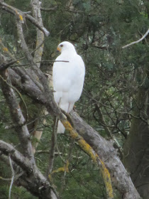
It isn't exactly suited to riding but I managed to haul the bike over rocks, under branches, around trees and even down some steps without too much difficulty. It was as the trail neared the point where it rejoins the main track along the river that I saw a large completely white bird land in a gum tree on the opposite side of the river. At a quick glance and at that distance it could have been a cocky or maybe even a small egret, however I spotted thick yellow legs and it was a little too chunky to be a cocky.
Grey Goshawk - white morph at Fyansford
I worked my way up as close as I could, took some shots and then decided to head round to the opposite side of the river beside the golf course. By now I was fairly certain that as predicted by the guru, I had found a white morph form of a Grey Goshawk. A couple of minutes later and I was on the opposite bank. The problem was that by now, so was the goshawk. Hmmm! I was a little closer than before and snapped a few more shots as the bird watched me for a while then moved a few trees up and then a few more. At this point I swapped back to the opposite bank. So did the goshawk. Grrrr!!
Grey Goshawk - white morph at Fyansford
And then things started to get interesting. With a screech and a rush of wings, a magpie went hurtling over the head of the goshawk which ducked and moved to a lower branch before finding a slightly more distant tree. This appeared to suit the magpie and its mate even less than the previous perch and both then proceeded to make numerous diving attacks on the goshawk, screeching and swooping at significant speed. The goshawk endured this indignity for some time, hunching as each attack came but not looking too concerned, before eventually deciding enough was enough and taking off for good.
Once I got home some more Googling and a quick check of the Birds in Backyards website informed me that the white morph of the Grey Goshawk is the only pure white raptor in the country. For obvious reasons it is also known as the White Goshawk or also self-evidently, the Variable Goshawk. It is found in Tasmania, along the north west coast of the mainland and the Victorian coast line. The grey morph is mostly found along the east coast.
Another point which was reiterated as I attempted to photograph the goshawk was the difficulty of taking shots of white birds. They are terribly prone to coming out glary and over exposed even in what should be relatively ordinary shots. The goshawk was no exception, so it looks like I will need to head back to Fyansford to see if I can improve my technique.

21 April, 2012

The hotter Half

Last Sunday along with around 1,100 of my newly acquired best friends, I dusted off the running shoes and hit the river. It was the first Sunday after Easter which can only mean one thing - the 24th annual Geelong Half Marathon - and I fronted up for my fourth official attempt.
I hadn't done a great deal of training over any significant distance - one 16km run about a week and a half out from the day - but had been running shorter distances regularly in reasonable times. On Saturday I trotted down to the clubrooms to pick up my running kit and strolled home in the autumn sunshine.
Likewise, Sunday morning dawned sunny, pleasant and by the time we were ready to start running, about 20 degrees, which is great when you're standing around at the starting line wearing little more than a thin layer of Lycra, but five minutes after the starter's gun goes it is a very different matter. By then - as is always the case in warm weather - I am desperate for an instant cold snap.
3km into the run and everyone was still in pretty good shape
Of course I had no such luck and the temperature continued to rise throughout the run. I always find it difficult to drink and run, but given the conditions, I grabbed what I could at the drink stations and tried to get at least some of it into me - a wise decision as it happens.
Water sachet in hand, but not sure where
on the course we were at this point
According to an Advertiser article the next day, two people were hospitalised with heat stroke and quite a number more were treated for dehydration. Luckily I wasn't one of them, however I did see one unfortunate at around the 17km mark who was in quite a bit of distress. By that stage, I was pretty much operating on pure will power which I find is always the case over the last 5km or so.
19km down, 2km to go and yes, I did catch the guy in front,
but the guy behind caught me

It certainly wasn't the day for most of us to be breaking records or beating our PBs, however there was one record broken when Stephen McAdam and Nathan Saber broke the record for the fastest half marathon completed by two men in a camel suit - yes, really! It was of course a charity run which they completed to raise money for Jim Stynes' Reach Foundation. Despite the heat, they made it home 6 minutes inside the time they required and will take their place in the Guinness Book of Records.
Two men in a camel suit, photo from
The Geelong Advertiser
I made it to the finish line in quite a reasonable time considering the weather - only my time from 2010 was better - finishing ahead of 70% of the field and ahead of 84% of the other women in the field. My official position, after a slow start trying to wade through all the opposition was 296th of the 953 of us who finished the race. I didn't manage to crack the - for me - magic time of 1hr 45min, but 1hr, 46min, 21sec will have to do.
The crowd welcoming home the stragglers
This year's event was the biggest field to date, despite the hot conditions. If the numbers continue to increase as they have over recent years, then I'm not sure how they are going to fit us all on the track next year. Whatever they do, we can only hope that the weather on 7th April, 2013 is a little cooler than the 15th April was this year!

15 April, 2012

Branching out - Bungal Dam

The last stage of Wednesday's Lal Lal excursion was to have a closer look at Bungal Dam. By this stage we were fast running out of time and then spent much of that attempting to navigate along winding gravel roads with limited signage. The GPS spent half its time with no signal and the other half being as confused as we were. Big help!
We did however manage to get there in the end and with only a few minutes to spare, grabbed a couple of quick pics and headed for home. This means of course that I did not have a chance to follow the service track which appeared to lead down closer to the dam's edge or to look at any of the infrastructure including the dam wall itself or the water tower which I glimpsed from the bottom of the road.
Lal Lal Reservoir from Bungal Dam Access Road, April 2012

All of that will have to wait for a future visit - preferably in a 4WD if I have to negotiate Bungal Dam Access Road again! For now I will have to make do with a few photos of sparkling blue water lying between eucalypt and pine covered hills and a little internet research.
The Lal Lal Reservoir or Bungal Dam as it is known has quite a reputation to live up to. As I described in an earlier post, the local indigenous population were the Tooloora Baluk clan of the Wathaurong tribe. They, along with the Kulin nation of indigenous peoples believe that the creator spirit Bundjil - an eagle - made his home at Lal Lal Falls. It was Bundjil who created the kangaroos, emus and all the animals of the earth. He created the first humans at Kirrit Barreet (Black Hill) a now extinct volcanic peak to the north east and once finished he created the Lal Lal Falls to relieve the monotony of the landscape - apparently even Wathaurong deities were aware of the limited scenic opportunities of livng on a basalt plain.
Basalt rock piles on plains near Bannockburn
Not surprisingly, when European settlers arrived, they also discovered the limitations of a basalt plain. I have heard it said that the crop that grows best on these plains is rocks and there are certainly a lot of them. The early settlers used them to make dry stone walls and as they cleared the land for farming, they placed the left overs in piles which still dot the landscape in these areas.
Basalt rock pile near Bannockburn
But, back to Lal Lal and its dam. It is of course from the spirit Bundjil, that Bungal Dam takes its name. The dam itself is an earth and rockfill construction, 49m in height which can hold upto 60 million cubic metres of water. The rock used to fill the dam wall was - not surprisingly - locally quarried basalt.
Construction of the dam was first considered following the drought of 1967-8 when the West Moorabool Water Board was established to oversee the project. Construction was started in February, 1970 by Premier Henry Bolte and was completed by 1972 at a cost of $5 million. It was officially opened on 24th November, 1972 by the newly appointed Premier Rupert Hamer. The water it contains is mostly used to supply Ballarat who draw about two thirds of their water from the reservoir. The remaining portion supplies about one third of Geelong's water requirements.
View of Lal Lal Reservoir looking east from the Moorabool Falls walking track
The West Moorabool Water Board was disbanded in 1995 and the reservoir is now jointly managed by Central Highlands Water and Barwon Water.
Water levels in the reservoir currently stand at around 93% full, however during the most recent drought which did not end until 2010, water levels reached critical levels which not surprisingly affected water quality. It also had a significant impact on the health of the Moorabool River below the reservoir, resulting in this river being declared one of the most stressed in Victoria. Since the breaking of the drought in the winter of 2010, things have improved, however the Moorabool below the dam still requires the release of "environmental flows" to support and improve the condition of the river and its environs.


13 April, 2012

Branching out - Moorabool Falls

And then one became two...
I am definitely not a geologist, but there is something rather cool about the fact that a waterfall can be in one place in one era and can then wind up a couple of kilometres upstream the next. Or, in the case of the Lal Lal and Moorabool Falls, can end up in two different places on two separate waterways.
Confluence of the Moorabool River West Branch and Lal lal Creek at the
top of Bungal Dam
Having finished our lunch and looked to see what von Guerard found so interesting about Lal Lal Falls that he was moved to paint them in 1853, we jumped back in the car and zipped round to Harris Road to the start of a walking track which leads to another nearby waterfall. This second feature of the landscape is the Moorabool Falls, located on the west branch of the Moorabool River, a short distance above its confluence with Lal Lal Creek.
My last post described how the Lal Lal Falls have been busily migrating up the creek, cutting through the relatively recent basalt lava flows of the last few tens of thousands of years. Meanwhile, over on the West Moorabool, the Moorabool Falls were busy making progress of their own, working their way through a different part of the same basalt flow.
Granite Falls, a series of cascades which flow over granite remains about
400m up the Moorabool West Branch from its confluence with Lal Lal Creek
In fact, a little research tells me that the two falls were originally one and the same. A few million years ago, water flowed over the edge of the basalt at a single "knickpoint" in the west branch of the Barwon. Some more research and I now know that a knickpoint is the point at which a sudden change occurs in the slope of a river, being much lower downstream of the knickpoint where water has carved a deeper path. It is often associated with "headward erosion" which is caused by the flow of water at the mouth of a stream eroding the riverbed.
Moorabool Falls, April 2012

In the case of the Lal Lal and Moorabool Falls, headward erosion began at a single knickpoint below the junction of Lal Lal Creek and the Moorabool West Branch. Over time and as the erosion reached the confluence of the two streams, the single waterfall, divided into two and the erosion continued up both branches. That which occurred in Lal Lal Creek has so far moved over 1,600m to the present site of the falls, whilst the erosion of the West Moorabool has traveled some 1,400m upstream to where the Moorabool Falls are now.
Moorabool West Branch just below Moorabool Falls
These falls are not so large as the Lal Lal Falls, dropping only 27m in total, nor do they have the striking basalt columns of the other falls. This is because the lava at this point cooled more quickly and unevenly than elsewhere.
West Moorabool between Moorabool Falls and Bungal Dam
Our walk to these falls also provided me with another piece of information. One which is slightly at odds with a previous post. The information board at the falls informed me that Moorabool was a Wathaurong word possibly meaning "mussel" or perhaps "stone curlew". A source I referred to in a previous post, indicated that the name was derived from the Wathaurong word "moora" meaning ghost. Another alternative it gave was that Moorabool may also refer to a nocturnal bird called a "cooloo" which could not be seen but whose call could be heard. Bush Stone-curlews are predominantly nocturnal birds whose breeding call is a long drawn out wail described as sounding like "werlooooo", so perhaps these two sources were not so much at odds as they might first have appeared.
I have never seen a Bush Stone-curlew, nor do I know if they were ever found on the banks of the Moorabool River.

Branching out - Lal Lal Falls

Yesterday we headed off to investigate a part of the Moorabool which I had not so far seen but which I mentioned in a recent post. I suspect more than one post may be required to cover our adventures, so here is the first.
We started slightly off track with a picnic lunch at Lal Lal Falls which are not currently flowing, but still make interesting viewing.
Lal Lal Falls, April 2012
The falls, which measure about 35m, are not on the Moorabool River, but rather, on Lal Lal Creek which joins the Moorabool West Branch a little downstream of the falls where both flow into Bungal Dam - the major water source for Ballarat and also a part of Geelong's water supply.
The confluence of Lal Lal Creek and the west branch of the Moorabool
River at the head of Bungal Dam

Like much of the Moorabool, this part of the creek runs through a deep gorge. The waterway is being formed by water carving a path through two lava flows which followed the path of an earlier valley. The first flow - between 2 and 5 million years ago - came from a now extinct volcano near Clarke's Hill (20km north) whilst the second flow - as "recent" as 50,000 to 100,000 years ago - came from Mounts Buninyong and Warrenheip.
Lal Lal Falls, April 2012
The very informative noticeboards at the picnic area and along the walking tracks tell me also that the falls are on the move. Over the last 2.5 million years, the effects of water erosion have seen them move 1.5km upstream. As this migration continues, the falls will eventually connect with Lal Lal Swamp which lies on softer, older granite near the township. By this time, the falls will be little more than a series of rapids over which water will flow on its way down the creek bed. A quick look at Google Earth will show the path of erosion so far, with the gorge clearly visible below the falls.
All of this geological activity means that the falls themselves are quite unstable - a fact which was highlighted in 1990 when two students who were abseiling down the falls with a school group died in a rockfall. This and other rockfalls at the falls have been used to calculate the rate at which the falls are migrating. Not surprisingly, they have since been closed to public access.
View of the gorge looking downstream from the falls
Lal Lal Falls is of substantial indigenous significance. Not just to the local Tooloora Baluk clan of the Wathaurong people, but to all the peoples of the Kulin Nation which extends across most of central Victoria. It is here, at Lal Lal Falls they believe that Bunjil, the eagle creator spirit of their people made his home, creating the falls as a place to live before being blown with his family into the sky. From there, he watches over his people and the light from his fire illuminates the planet Jupiter which they call Bunjil. It is from this legend that Bungal Dam takes its name.
A number of local landmarks also bear versions of thir Wathaurong names: Mt Buninyong for example is derived from the word "Puninyong" meaning "big hill like knee" and Warrenheip comes from the word "Warrenyeep" meaning "emu feathers".
Lal Lal Falls looking north. Mt Buninyong can be seen in the background.
The famous artist Eugene von Guerard painted the falls from this aspect in 1853.
In more recent times, Lal Lal Falls were of significance to the early European settlers who came here to picnic and take in the sights. Artists and photographers were also drawn to the views and the area became popular as a meeting place where races were held in the 1870s and 80s. A large grandstand with a seating capacity of 1000 was built for racegoers who travelled to the venue on a branch line built in 1885. A record crowd of 32,000 was recorded in 1937, however its popularity declined rapidly in the face of other regional competition and the last meet was held in 1938.
Today, the falls and surrounds are a quiet picnic area with walking trails and a mixture of remnant vegetation, plantings of pine and various deciduous trees from the 1880s and more recent native replantings. There is also a wide variety of bird and animal life in the surrounding reserve.

07 April, 2012

Tragedy of the Barwon!

And so to 1949, by which time, European settlement was over 100 years old and much of the Barwon River environment had changed almost beyond recognition. Many of these changes were unfortunately, for the worst - a fact which was recognised by those who came into contact with the river and who sought to find solutions to the problem.
However with the benefit of modern scientific method and the clarity of hindsight,the suggestions as to what should be done to address the problems of 1949 seem somewhat at odds with today's conservation and management methods. Without giving too much away, the prospect of what a freshwater Lake Connewarre would have meant for the local wildlife is alarming. I also note that a recent study aimed at determining the flood risk and stormwater requirements of the new Armstrong Creek development, points to increased flooding due to the loss of ephemeral streams draining into the Barwon. The loss of these streams has resulted from past farming practises in the area aimed at clearing and draining the land.
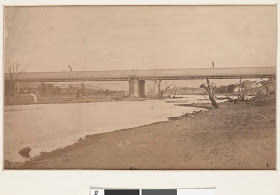
The following article therefore is an interesting example of the attitude of the time. For interest's sake and to illustrate conditions along the river at various times, I have included some historical photos. These were not part of the original article but will hopefully provide some extra interest.
And so to the article:
The Argus, Saturday, 14th May, 1949

Tragedy of the Barwon
By GORDON WILLIAMS
Time was, before the precise balance and the impeccable mechanism of Nature were disturbed, when the Barwon River was a stream of rare beauty and high value, both real and potential. Now as it flows sluggishly around Geelong to find its loggy, turgid way to the sea, it has relatively little attraction, sharply limited use, and a murkily doubtful future.
The Barwon Bridge (Moorabool Street), 1861 looking West. Image held
by the State Library of Victoria
Barwon Bridge rebuilt in 1926 looking east (1925-1954). Image held
by the State Library of Victoria


Barwon Bridge 7th April, 2012
Around and above its mouth, where there are lands, it could be stimulating and for cattle it should be refreshing; it is – or was when I saw it recently – a rather dispirited stream, somewhat conscious of its own stagnation and futility… Now and then, however, it revolts against its man-made condition, swirls into flood, and sweeps across wide plains in revolt, and where it goes it leaves the scars of its passing.

Between Geelong, second city of a great State, and its point of union with the sea I saw a river ripped by snags, choking with weed, and so confined and contained as to be (in parts, at least) noisome.
Barwon River near Geelong c1900. Image held by the Victorian
State Library
Yet, there was a time… As Mr E.F. Guye, of Winchelsea, told the Parliamentary Public Works Committee about three years ago, the story of the Barwon is the story of every river in Victoria. Settlement and the clearing of forest lands he said, had upset Nature’s balance, and the result was the creation of problems.
Speaking of the higher reaches of the river, he told of the effect of scour, and of severe creek erosion; he drew a depressing picture of a stream choked with trees and logs, part-strangled by silt.
Around Winchelsea and Biregurra, the river in summer fell to a desultory trickle, most of that flow being provided by highly mineralised springs which “make the water useless when it is most needed;” higher up the river still, in the Gherangamate(sic) and Barwon Downs areas, blocking by refuse rendered useless thousands of acres of rich river flats. There the farmers have too much water. Lower down there is not enough…
Appeals Disregarded
The Committee heard a distressing story of development retarded, even arrested. Up and down the river, from mouth to source, there was a cry for improvement.
Broadly, those in whose lives the river plays its vital part asked for:
  • Snagging of the east and west Barwon Tributaries of willows and logs which were ruining, by causing the flooding of, large areas of river flats in that area.
  • Provision of a storage basin at The Fork paddock to allow release of water during the summer.
  • The arrest of further creek or other erosion.
  • The snagging of the midreaches, and the provision of weirs with flood gates to raise the summer level of the river flow.
It was emphasised that purification of the river, by the release of freshing and flood waters, was of necessity a first priority work.
At first glance, this seems a formidable list of requests. Compared with the importance of their object – the repair of the stream, and its establishment as a supporter of local and State economies – it is, however, relatively small.
But the Committee issued no report; made no recommendation. At the time both the committee and the State Rivers and Water Supply Commission were faced with greater jobs – the new Eildon project among them; the Barwon had inevitably , a low priority. Moreover, the Commission, harassed then and even more harassed since, by a shortage of expert staff, was incapable of tackling all the work it wished to do…
Both authorities, one can well imagine, sighed sadly, marked up a new frustration.
The Barwon preserved its status quo… Its promise remained only a promise. Its disabilities, and its power of destruction continued.
The river and all its tributaries rise in the OtwaysWhittlesea(sic) to Inverleigh, and lack of water there in summer.
Wool scours on the Barwon at Breakwater, 1937. Image held by the Victorian
State Library
Wool scour on the Barwon at Breakwater 7th April, 2012
Around the mouth, and upward from it to Geelong, there is almost tragic evidence of the main stream’s deterioration.
Downstream, there are two breakwaters across the Barwon, designed to prevent the sea from carrying its salt upward. The first is about 14 miles from the mouth, on the south-eastern fringe of Geelong; the second is about five miles farther down.
Once there was at the first “break,” about 20 ft of water. Yet a week or so ago, after the heaviest February-March rains in 20 years, only about 6 inches of water was passing over the barrier!

Dirty Waters
This insignificant flow means that the stream between the two breakwaters is almost completely stagnant, and stagnant streams close to cities have a way of becoming unpleasant – and dangerous to all living things.
“Rubbish of all sorts finds its way down here,” I was told by residents. “The breakwaters just hold the stream up, just prevent flow. We see dead cats, dogs, even bullocks, floating and milling about.
“The top breakwater should be removed immediately – both of them could go; another to prevent salinity could be built at say, Ocean Grove. It should have sluice gates through which a flow of water can pass to cleanse the stream, and relieve low-lying land from the menace of flooding every four or five months. The existing breaks are just walls; we’ll never get the stream clear or our land protected while they are there.”
This view is expressed generally, and the works involved seem trifling in view of the benefits to be obtained – trifling, even in present circumstances.
I saw plenty of evidence of what a stagnant, or near-stagnant, river can do. Swelling, it spreads, finding its level here and there in great and small patches. The water is often polluted; many paddocks bear its brand, great brown patches that seem to have been seared by fire.
“Twenty years ago this country grew some of the State’s best oaten hay. Now great spreads of it are dead under your boots. Even those indefatigable workers, the Chinese, could not make a go of it on the river flats. They were driven from their market gardens. Yet, if this stream were allowed to flow cleanly and sweetly, the lands from the mouth to Geelong would supply the city, and Melbourne as well, with all their market garden needs; Geelong could have its own local milk supply from its own district dairy herds… At times now that supply must be supplemented from Melbourne and Colac.”
This was the pattern of the stories I heard almost endlessly. I was shown, on St Albans, a reservoir that once held a quarter of a million gallons of sweet river water. Today, it is choked and ugly with weed.
The stock that should be watered from it now draw from the Geelong water supply, adding to the burden of that already overburdened system.
As we stood gazing over the lovely, rolling landscape that marches boldly up to the Leopold hills, Mr H.G. Raymond, bloodstock breeder, of St Albans and Mr “Chappy” Hinchcliffe, who farms near by pointed out to me paddocks where once fine heards of bullocks fattened. Now, they are wasteland, the sport of the river.
And all this within a few miles of the State’s second city.
It is true that here and there land is being irrigated from the river, but many farmers believe that the effort is doomed. The soil will not stand the water’s hostility, they say.
Yet, the quality of the country is revealed on the Hinchcliffe property. Here there are stacks of surplus fodder, taken from soil nurtured by water drawn from Reedy Lake, which is filled from the Barwon. Mr Hinchcliffe brings the lake water to his land through channels laboriously hand-dug. It is then delivered into “basins,” whence it finds its way to its destination.
This is river water – but in its transference from lake to paddock it passes through a process of filtration, and reaches the land clean.
“I would have been off my place but for that water,” Mr Hinchcliffe says. “A former Government planned to place a breakwater at Tait’s Point, then to bring a gravity channel around Reedy Lake for irrigation. If that had been done, another 10,000 acres in this valley would have been brought into cultivation…”
Other thousands of acres near by could be made cultivable too. The land has high reclamation value, as is shown by the fact that before the breakwater nearer the mouth was built the river was salted right up to St Alban’s. Now great stretches have been cleansed and brought into profit.
These are but a few of the features, and the facts, of that sadly neglected stream, the Barwon. There are others – notably the local contention that if the existing breakwaters were destroyed, and one, sluice-gated, built at Ocean Grove, Lake Connewarre would become a great freshwater stretch, with about 30,000 acres brought into higher production…
As I saw it, the Barwon around Geelong is a struggling, unattractive stream, performing only a fraction of its function.
The Barwon needs – demands – attention.

The flow of progress

Over the past 180 years since European settlement, attitudes towards the care and management of the Barwon River have changed dramatically. A look at newspapers over the years also shows quite a difference in priorities between now and the 19th and even well into the 20th century.
The Barwon River at Queen's Park c1866. This image is held by the State
Library of Victoria
Whilst the Moorabool during the drought years of the last decade has been described as one of the most stressed rivers in the state, the Leigh and Barwon Rivers do not seem to have suffered so greatly, with a shortfall in water volume estimated at about 4,700ML (per year I assume) in a paper published by the government in 2006. Recent years of good rainfall have no doubt improved this situation somewhat. At the time of publication, the upper reaches of the Barwon were described as being in good condition, however the lower reaches were not so healthy, despite having what was considered to be an adequate level of water flow.
In the next few posts, I will transcribe some articles which were published in The Argus newspaper (now The Age) in the late 19th and the 20th centuries and which provide an interesting comparison to the attitudes of conservation and regeneration which are espoused today.

The Barwon River at Queen's Park c1882. This image is held by the State
Library of Victoria from the Fine Art Photographs of Victoria
The first article appeared in The Argus, Thursday, 24th March, 1892:
Complaints have been made regarding the pollution of the Barwon River at South Geelong, a process which has been going on for many years past. The evil effects of it, however have not been manifested to any great extent until lately, when the odours from the stagnant pool have become almost unbearable. In a particular part of the river the water has actually become fouled from decaying organic matter and the steady flow of liquids from tanneries, fellmongeries and wool-scouring premises, and in hot weather the smells arising from the river have been of a most unpleasant nature. The health committee and officers of health of the town have awoke to the existence of the nuisance, and after examinations and analyses they decided today to recommend that prompt steps should be taken to apply a remedy. It is proposed that each factory should provide filter beds for catching the refuse from the factories and running the liquids into charcoal, &c, with the view of preventing a continuance of the nuisance.

Barwon River at Queen's Park, 1937. This image is held by the State
Library of Victoria
The following article appeared in The Argus, Friday, 28th November, 1924:

State Asked to do Work.

Following a conference at Geelong on October 10, at which was discussed a plan for the improvement of the Barwon River, representatives of the City of Geelong, the towns of Geelong West, Newtown, and Chilwell, the shires of Bannockburn, Bellarine, Corio, and South Barwon, the Geelong Harbour Trust commissioners, and the Barwon River Navigation League, who were present at the conference, waited on the Minister for Public Works (Mr. Goudie) yesterday to ask for the removal of a breakwater and the construction of a lock on the Barwon River.
Mr. Richardson, M.L.C., who introduced the deputation, said that the state of the Barwon River had been acause of dissension among the people of Geelong for more than 50 years. As they had been unable to reach an agreement it had been decided to ask the Ministry to settle the matter. It was desired that the breakwater, which hampered the flow of the stream, should be removed; that salt water from the sea should be prevented from going up the river and rendering the water unfit for stock purposes. At the same time the plan would have to make provision for the periodical flushing of the river, as it flowed very slowly. In the lower reaches, near the factory sites, the river became in summer practically a cesspool. The adoption of the plan would enable an area of about 1,750 acres to be reclaimed. Land in the vicinity was worth about £60 an acre.
Mr. Brownbill, M.L.A., supported the request.
M4 Goudie said that the matter had to be regarded from the viewpoint of the Treasury, as the plan would entail the expenditure of a considerable sum of money. The many changes in the Ministry had increased the cost of administration, and he would like to know whether, in the event of the Ministry adopting the plan, the municipalities concerned would be prepared to contribute to the cost of the undertaking. Meanwhile he would send one of the departmental engineers down to inspect and report on the river.

The Barwon River at Queen's Park, c1920-1954. This image is held by
the Victorian State Library
And this is how the same view looks this afternoon on 7th April, 2012:
Queen's Park Bridge 7th April, 2012

In the next post we will step forward to 1949.


03 April, 2012

Turning on the waterworks

Our latest excursion to investigate the local waterways saw us head to Stony Creek in the Brisbane Ranges over the weekend. We started from the Stony Creek Picnic Ground - having previously walked most of the section of track from Anakie Gorge up Stony Creek - and followed the Ted Errey Nature Circuit. The late Ted Errey, I discover was the president of the Geelong Field Naturalists Club and a keen advocate of the national park.
We followed the path up a spur to the high points overlooking the gorge below and from various lookouts interspersed along the track, we could see Mt Anakie and away towards Corio Bay, extensive views of the Brisbane Ranges which are still recovering from the 2006 bushfires and the Lower Stony Creek Reservoir.
Ted Errey track showing regrowth after bushfire damage
This latter structure forms part of Geelong's water supply and is in part the reason I can justify including the Brisbane Ranges and Stony Creek in my Barwon Blog. Whilst the creek is not a tributary of the Moorabool River - it discharges into Little River - water from the east branch of the Moorabool River is diverted in to the Stony Creek Reservoirs for transfer to Geelong.
So, how does it all work?
In 1841, as I have blogged previously, Captain Foster Fyans had the breakwater constructed across the Barwon to improve Geelong's water supply, however by the 1860s the supply from the Barwon was both inadequate for the town's needs and was polluted by the local industry.
View across Brisbane Ranges with Lower Stony Creek
Reservoir in the middle distance
It was decided that a new, more reliable water source was required. So, to cut a long story slightly shorter, after the expected political wrangling and corner cutting, a dam was built across Stony Creek in the Brisbane Ranges. This initial earthen wall dam (Stony Creek Reservoir 1) was completed in 1873, but some subsidence in the dam wall meant it would have a smaller capacity than anticipated, so the Lower Stony Creek Reservoir was built further down the creek - with a concrete wall - between 1873 and 1874. From the upper reservoir, water was sent via an aqueduct to the Anakie Pipe Head Basin and from the lower reservoir via a pipe running beneath Anakie Gorge to a point below the basin. From here, the water was distributed to Geelong via storage basins at Lovely Banks and Montpellier.
Decommissioned waterpipe from the Lower Stony
Creek Reservoir, exiting a tunnel and crossing the creek.
The pipes were originally constructed from timber
By the turn of the 20th century however, even these measures were inadequate for Geelong's water needs, so a diversion weir - the Bolwarrah Weir I believe - was built on the East Moorabool River. The weir was designed to raise the water level of the river at this point allowing some of the flow to be diverted into a channel - the Ballan Channel - which then carried water to the Upper Stony Creek Reservoir.
As Geelong continued to grow, more water was needed and over the years, much of this continued to be drawn from the Moorabool River. Water first flowed into the Koorweingaboora Reservoir located upstream of Bolwarrah Weir near the headwaters of the Moorabool East Branch in 1911, then in 1914 and 1918 the Upper Stony Creek Reservoirs 2 and 3 respectively were completed.  In 1940, the capacity of the Ballan Channel was doubled to allow more water to be drawn from the upper reaches of the Moorabool East Branch and by 1954 the Bostock Reservoir, located on the Moorabool East Branch just outside Ballan and below the Bolwarrah Weir, came on line. It is also connected to the Ballan Channel via its own open channel - the Bostock Channel.
But that is not the end of the story. Along the west branch of the Moorabool River are two significant reservoirs. The Moorabool Reservoir was built near the headwaters of the Moorabool West Branch in 1915, then, in 1972 the Bungal Dam was built at Lal Lal. This latter reservoir at the time it was built was equivalent in volume to Geelong's total water storage.
Most recently in 1999, the pipes and the channel which for so many years carried water from the Stony Creek Reservoirs to the basin at Anakie were decommissioned and replaced by a pipe running along the Steiglitz-Durdidwarrah Road. In total about one third of the water taken from the Moorabool River system is available to Geelong with the remainder being used by Ballarat. This accounts for approximately one fifth of Geelong's water requirements. The remainder is supplied by the Barwon River system and in more recent years by borefields at Barwon Downs and Anglesea.
Phew! So, back to our walk. In some places the track was rocky and only vaguely defined, although the blue trail markers helped keep us on course. In other places we were walking along access tracks which were broad and reasonably level.
Rocky section of the Ted Errey Track
We reached the summit, took in the views, snapped some shots and continued on our way, however a little under half way in, we were informed that the Ted Errey Trail beyond Switch Road was closed. Being the intrepid adventurers we are - and having ignored such signs before with no noticeable ill effects - we decided to soldier on. All was well as we crested the rise and headed down the steep, rocky slope which took us back to the bottom of Anakie Gorge, to connect with the trail which ran along beside the creek. We were within 2km of reaching our goal when we came across our first obstacle. A small weir which I'm sure we walked across on a previous occasion, was now under a small amount of water.
The one flooded weir we didn't need to cross
Hmmm... never mind, we could remove our shoes and cross without too much trouble. This we did. Problem solved - until we came to the next point where the path crossed the creek. There was a bridge, but it was on its side, somewhere downstream of where it should have been. Again, the creek wasn't too deep or wide, but the thought of having to deal with the shoes again didn't appeal, so we resigned ourselves to getting wet feet and plunged across. Once again we all made the opposite bank without having to fish any children out from some point downstream.
Yet another creek crossing
Done! Now to finish our walk! That was, until we reached another point where the path crossed the creek - a second submerged weir - and another, and another and another. In all, we crossed the creek seven times. On six occasions we were confronted either with no bridge, a submerged weir or a missing bridge. I guess they meant it this time when they said the track was out of action! However, we did finally make it back to our starting point and within the specified time frame.
And so, we squelched our way to the car and headed for home.

Plaque at Montpellier Basin commemorating the centenary of
reticulated water in Geelong